
Background
Here is yet another episode of Bermuda tropical cyclone markets (previous ones here and here). According to different model forecasts, the path of Tropical Storm Philippe carries strong uncertainty beyond the next 2-3 days.
Per NHC:
"Philippe should continue west-northwestward over the next day or two, steered along the southern side of a mid-level ridge. In about 2 days, all models depict a weakness developing in the ridge, but the track guidance diverges quite drastically, and it is directly related to the intensity of the system. A deeper, stronger system, like the GFS depicts, will feel the weakness in the ridge and curve the system faster on a more northwestward track. However, a weaker, shallow cyclone, like the ECMWF depicts, will cause the system to continue on a west-northwestward or even westward track. The NHC track forecast continues to be in the middle of the guidance, and lies close to both the simple and corrected consensus aids. This remains a low confidence track and intensity forecast."
Will Philippe pound Bermuda with inclement weather shortly after Lee, or will its impact mostly be confined to the fishies?
Resolution Criteria
Resolves YES if Philippe brings tropical-storm-level winds (>34 knots, >39 mph) to any part of Bermuda while maintaining tropical characteristics.
Resolves NO if Philippe dissipates or becomes extratropical before the fulfilment of the condition for YES.
Will resolve based on Bermuda Weather Service and/or the National Hurricane Center data.
I will not bet on this market, but I will put Ṁ200 in as subsidy.
 1,000
1,000🏅 Top traders
| # | Name | Total profit |
|---|---|---|
| 1 | Ṁ398 | |
| 2 | Ṁ140 | |
| 3 | Ṁ138 | |
| 4 | Ṁ62 | |
| 5 | Ṁ45 |
Thank you very much again for the participation, especially the insightful discussion and input from @parhizj, @ChristopherRandles, @JoshuaHedlund and @LasseRasinen! I will begin the manual payout and refund for NO bettors shortly.
Meanwhile, please kindly consider participating in the tropical cyclone markets below. See you next time!
Some time has passed and the time for resolution approaches. I understand the cases for both YES and NO, given the marginal nature of the market. I think everyone so far has given reasonable arguments. After some deliberation, I am going to put this down to a weak YES, with provisions to manually pay out to the remaining NO bettors and make whole those who lost mana in this market after the resolution, and refinement of the resolution criteria for similar markets next time.
Please let me know if there are any comments or disagreements to this arrangement, especially from @AbsurdBird and @JavierChavez. Otherwise I will resolve this as YES in an hour or so.
First of all, thank you all so much for the very informative discussions and input on this market. It has been a very active and informational market, and I have learnt much from all of you tracking down Philippe during its tropical lifetime.
When I created this market over ten days ago, the likelihood for Philippe to impact Bermuda seemed a distant possibility. But even if it was to approach Bermuda, I had foreseen a relatively straightforward and clear-cut resolution like last time with Lee, but boy was I wrong, haha.
I have read the extensive discussions below by the very knowledgeable traders in this market, and I agree that the circumstances are quite marginal, like the Koinu market. The tropical storm has transitioned into an extratropical cyclone after being absorbed by a nearby low, before it enters within 100 n mi of Bermuda. And the irregular spread of the wind field further complicates the decision.
Still, per my reasoning in this comment, I am leaning towards resolving this market as YES, given the many above-34-kt average wind speed reading at the National Museum of Bermuda while pressure was dropping, and while the Tropical Storm Warning for Philippe was active, as noted by @parhizj. Indeed, two of the reasons why I had not decided to resolve earlier were because of the very valuable ongoing discussion, and that I want to gather more evidence in favour of the association between the elevated wind speed and the cyclone's approach.
Now that extratropical transition has occurred ahead of previous NHC forecasts, I am inclined to resolve this market as YES, but the discussions generated here will be very useful for refining future criteria for similar markets. For example, consideration of storm wind fields might lead to a more objective and verifiable measure of storm impact in an environment with multiple systems nearby.
Due to the nature of this market, I am going to leave this open longer than the other two markets before resolution, and I will tentatively set it at 8 hours from now. If you have any disagreements or comments regarding the resolution, please leave a comment below. Thank you again!
@SarkanyVar I agree this has been a fascinating and surprisingly ambiguous market! My initial impression is to argue for NO, because based on the wind history chart and the position of Philippe when NHC declared it post-tropical, it did not appear to reach Bermuda, satisfying the "NO" part of the description. However, the "YES" part of the description says "if Philippe brings tropical-storm-level winds" - I think the ambiguity all hinges on the word "brings," which is not clear whether it specifically only includes the tropical wind field of Philippe directly as defined by the NHC, or the complicating weather stuff that is associated with it. But then again Philippe has not always been clearly defined during its whole existence, as many of the NHC's Forecast Discussions have indicated. I sold earlier and have no skin in the game either way, and could honestly see a reasonable argument for either resolution.
@JoshuaHedlund I agree that the ambiguity in what constitutes as attributable influence by Philippe led to much ambiguity in here, on top of the extratropical transition imbroglio. What 'brings' means is not explicitly defined in the description of the market, and thus there can be variable degrees of laxness interpreting it. I agree that in future markets, something tangible like the wind history chart or the wind field coverage should be used.
Here, I am mostly following the precedent of the Lee market, which is a wind speed reading exceeding 34 knots after TS warning is declared - which in hindsight might not be as comprehensive and cogent a criterion as I had thought, given that TS warning can be declared quite a bit ahead of the actual arrival of the wind fields. So I am really grateful of the discussion by you and the other traders regarding this ambiguity. (This kind of thing is a reason I don't trade in my own markets, ha!)
Now, Post-tropical Philipe
https://www.nhc.noaa.gov/text/refresh/MIATCPAT2+shtml/061453.shtml
BULLETIN
Post-Tropical Cyclone Philippe Advisory Number 53
NWS National Hurricane Center Miami FL AL172023
1100 AM AST Fri Oct 06 2023
...PHILIPPE BECOMES POST-TROPICAL BUT STILL POSES A RISK OF FLASH
FLOODING ACROSS NEW ENGLAND THIS WEEKEND...
...THIS IS THE LAST NHC ADVISORY...
SUMMARY OF 1100 AM AST...1500 UTC...INFORMATION
-----------------------------------------------
LOCATION...30.7N 64.6W
ABOUT 110 MI...180 KM S OF BERMUDA
MAXIMUM SUSTAINED WINDS...50 MPH...85 KM/H
PRESENT MOVEMENT...NNE OR 20 DEGREES AT 16 MPH...26 KM/H
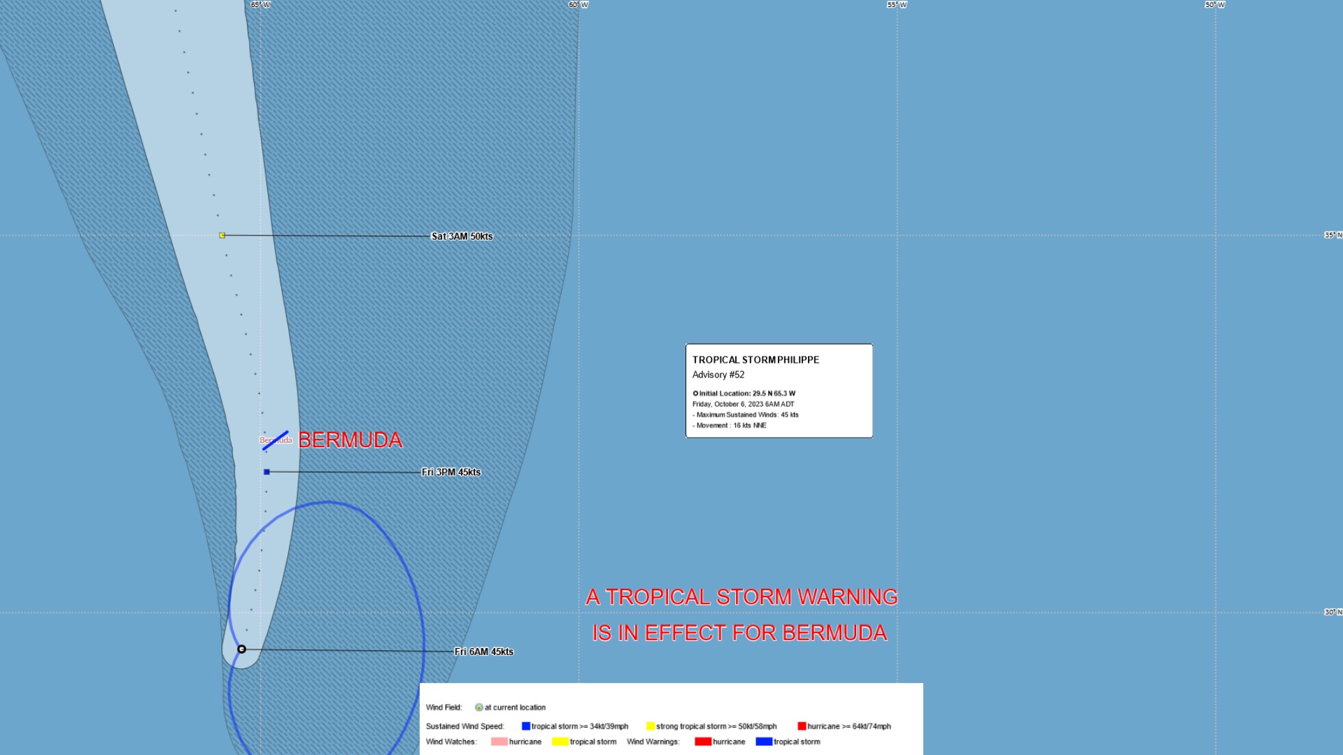
MINIMUM CENTRAL PRESSURE...1003 MB...29.62 INCHESForecast advisory with position:
https://www.nhc.noaa.gov/text/refresh/MIATCMAT2+shtml/061452.shtml?
POST-TROPICAL CYCLONE CENTER LOCATED NEAR 30.7N  64.6W AT 06/1500Z
POSITION ACCURATE WITHIN  45 NM

PRESENT MOVEMENT TOWARD THE NORTH-NORTHEAST OR  20 DEGREES AT  14 KT

ESTIMATED MINIMUM CENTRAL PRESSURE 1003 MB
MAX SUSTAINED WINDS  45 KT WITH GUSTS TO  55 KT.
34 KT.......180NE 150SE   0SW   0NW.
12 FT SEAS..210NE 210SE   0SW 150NW.
WINDS AND SEAS VARY GREATLY IN EACH QUADRANT.  RADII IN NAUTICAL
MILES ARE THE LARGEST RADII EXPECTED ANYWHERE IN THAT QUADRANT.
This position puts it about ~ 113 n. miles SSE of the national museum
Philippe is being declared a post-tropical cyclone.
The intensity remains 45 kt, mainly based on continuity.
Resolves YES if Philippe brings tropical-storm-level winds (>34 knots, >39 mph) to any part of Bermuda while maintaining tropical characteristics.
Declared at time of announcement or perhaps it had already transitioned to that in the last few hours?
@ChristopherRandles Given that the 34kt wind field for the storm was 150 NE (9 UTC) and is now 180NE (15 UTC), and given that the intermediate advisory had it just barely west of Bermuda at 12UTC (even though that the storm just now moved east of Bermuda during 12 to 15UTC), I think if going by storm wind fields you could make the case that the wind field expanded & the storm moved enough north in the interm after 9UTC (when it was only 165~ n miles away) when that 39 kt measurement came in at 10 UTC an hour later. It is close/marginal by that case, but it could be argued either way in this case.
If going by just spirit of the question as mentioned earlier by @SarkanyVar with the pressure measurements, and the many measurements of >=34 kt at the museum in the time beforehand when the pressure was still dropping and still not declared post-tropical, I think it resolves YES.
Latest BWS tropical update at local time 9 am. Closest approach is forecast to be 4 pm, about 6-7 hours from now.
BWS Public Forecast at 9:30 am:
Public Synopsis -
While most of the heavier rainfall has now passed, clusters of showers are still organizing into rain bands in advance of Tropical Storm Philippe, still approaching from our south, albeit at a slightly slower pace. Expect higher gusts in exposed or elevated areas as winds become tropical storm force at times; then winds ease while veering south after passing Philippe`s CPA. Dangerous swells and hazardous rip currents persist and will gradually abate through the weekend.
41.4 sorry wrong graph still 39.8 kts is that enough?
That was reported before, timed at ~6:56.
Recent is 36.5 at time of this edit.
Cautious wait expected.
For now I am leaning towards the available pieces of evidence, including the wind speed record at NMB you noted, are pointing to a YES resolution. The criteria for this market are direct duplicates of the previous Lee markets, and back then, the 2-min average wind speed at any weather stations in Bermuda during the approach, especially when tropical storm warning was active in Bermuda, was already sufficient for a YES resolution.
As I noted in the comments below, the spirit of these markets is to assess the wind impact by the approach of the cyclones. Unless we have convincing reasons that the recorded wind speed is not due to the tropical cyclone, even when tropical storm warning associated with said cyclone is active, a wind speed above 34 knots should be sufficient for the market to resolve YES.
There were some reasonable concerns that high winds recorded before the islands became enveloped by the wind fields noted in the updates and advisories might not originate from Philippe entirely, and I agree some caution is warranted in here.
But I think in general, if we are observing a drop of surface air pressure associated with wind speed increase as the cyclone approaches, and then these situations reverse as the cyclone departs, and that the highest winds congregate around the closest point of approach (not necessarily at the closest point of approach due to the possible irregular wind field of the cyclone), it is reasonable to conclude that wind speed records obtained within this period of time to be (at least partly) attributable to the cyclone itself.
Optimally, wind field data and wind history would lend support and confidence to the resolution, but I think it is not in the spirit of the market to resolve this as something other than YES, when there is a wind reading that satisfies the requirement when the cyclone is in the vicinity of Bermuda and necessitating an active tropical storm warning. While weather agencies might not give an explicit, very clear attribution, circumstantial evidence is still reasonably strong in this case, in my view.
Still, I welcome any comments and discussion regarding the resolution at this stage.
![[Image of cumulative wind history]](https://www.nhc.noaa.gov/storm_graphics/AT17/refresh/AL172023_wind_history+png/090048_wind_history.png)
@ChristopherRandles BWS expecting some westward turn ahead. But if it pass to Bermuda's east, the winds would likely be quite a bit weaker since the wind field is mostly to the east.
@SarkanyVar The latest Forecast Discussion from NHC says “Tropical storm conditions are beginning on Bermuda and expected to continue today”. But the next update should add clarity.
@SarkanyVar New NHC home page says “PHILIPPE BEGINNING EXTRATROPICAL TRANSITION... ...TROPICAL STORM CONDITIONS CONTINUE ON BERMUDA.”
doesn’t exactly add clarity 😂
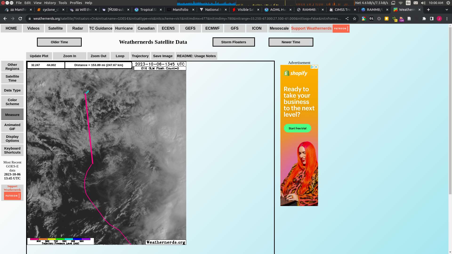
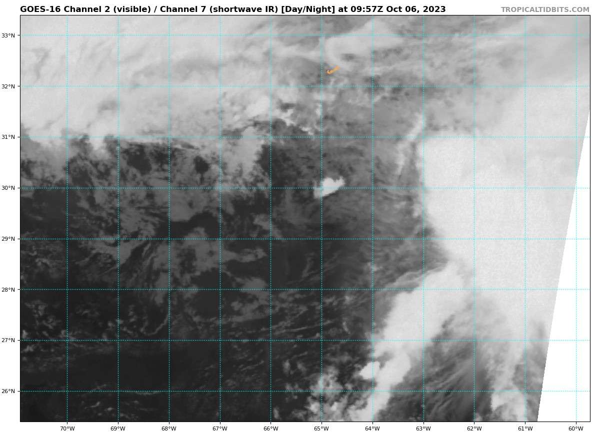
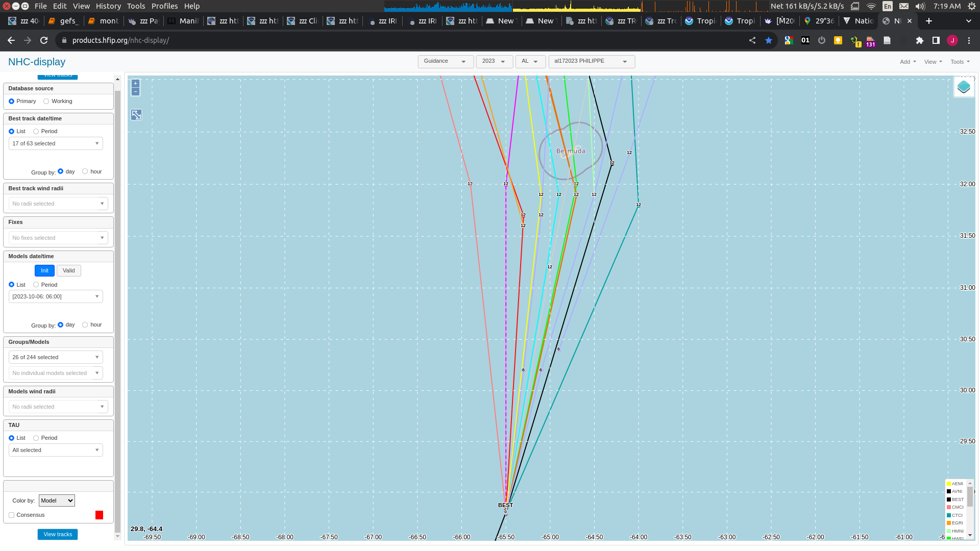
It's hard to identify the low level clouds but it it looks to be about ~ 29.9N 64.7E at 12UTC... in which case it is following closer to the CTCI track, which is the only (early) main model from 06Z having guidance going that far east.
GEFS had quite a range seemingly with 3 groups and the furthest East being more numerous than the other groups.

But this could be out of date.
NHC gave heading as 15 degrees but latest update says 20 degrees so trending more Easterly despite turn to North being forecast.
NHC has it at
29.9N 64.9W32.3078° N, 64.7505° W
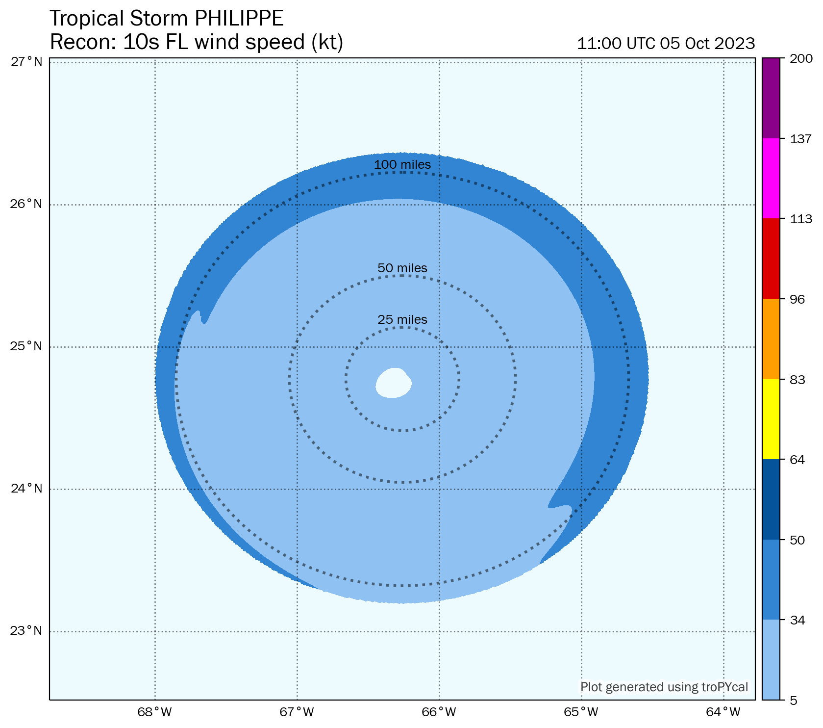
Very interesting looking wind speed composite map...
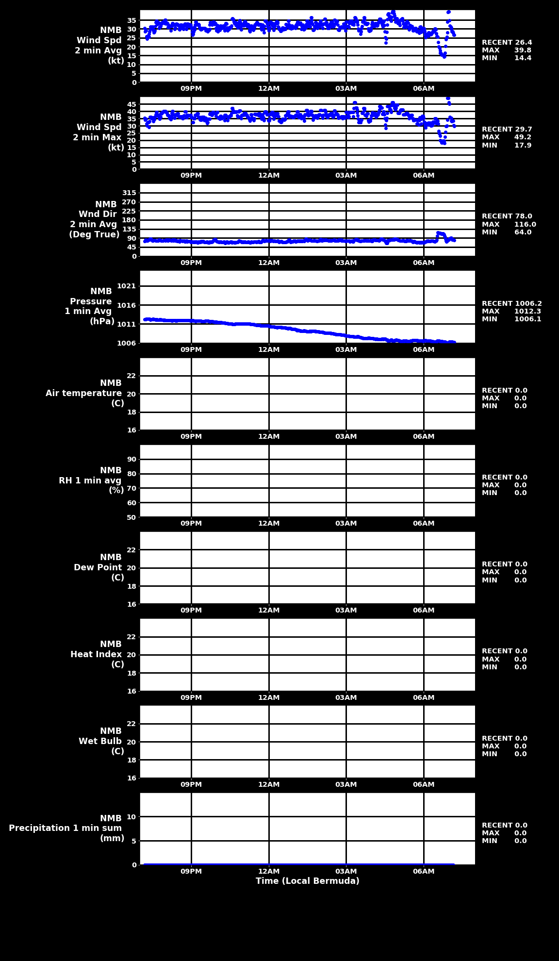
@SarkanyVar Any idea when that 39.8kt measurement was taken? The x axis is local Bermuda time but it's hard to tell exactly when other than between 6:30 AST and 7:30 AST....
@parhizj I opened it up in my image editor, and it seems that 3 hours ≈ 160 pixels. The point occurs at about the 50th pixel horizontally from the 6 am point, and thus corresponds to about 6:56 am Bermuda time.
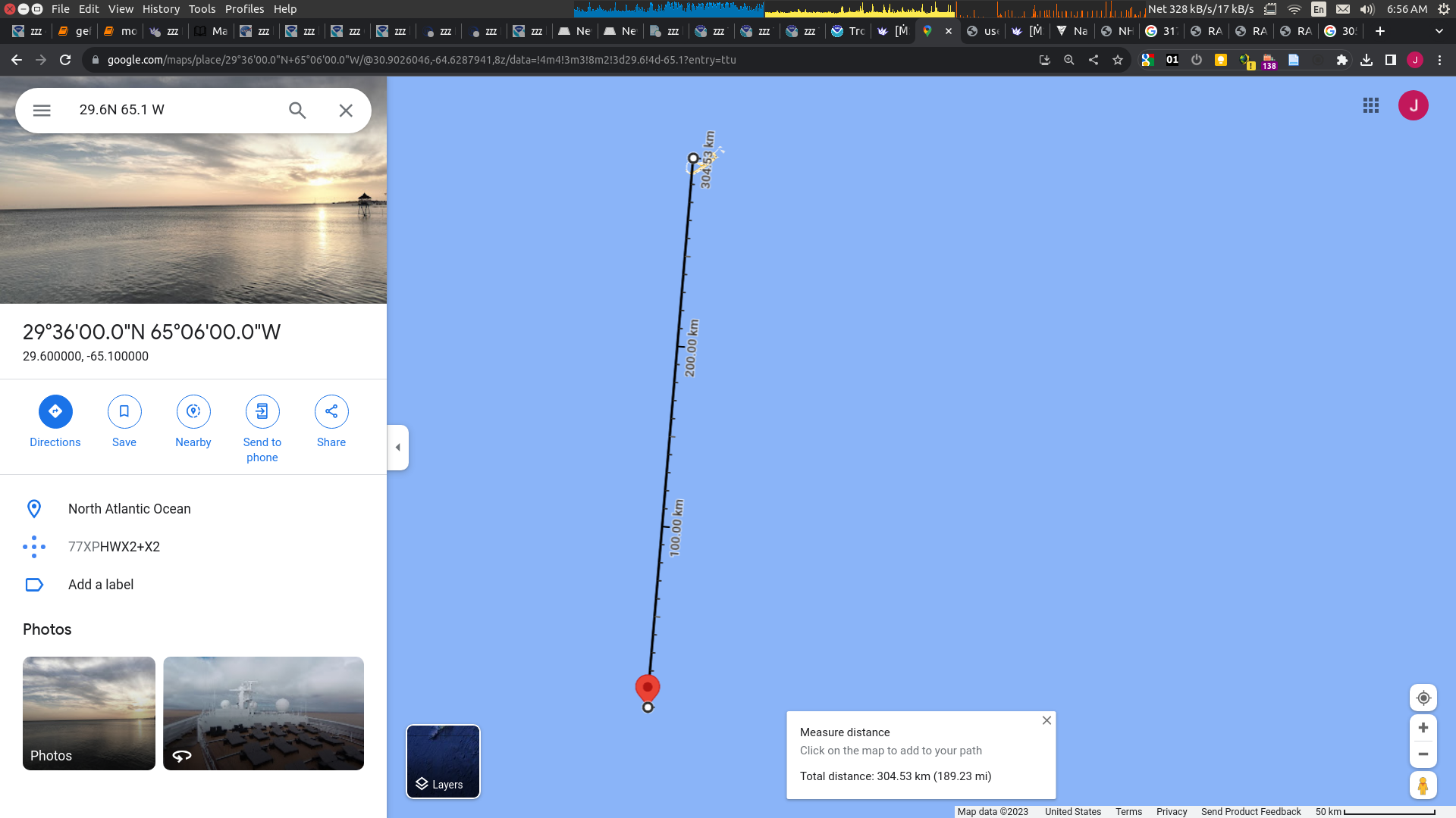
That is ~165 n. miles from the museum (~ 365 km ~= 165 nautical miles)
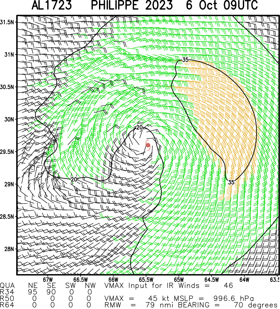
The estimated storm 34kt wind field is put at ~150 nautical miles ~one hour earlier (for the NHC 09 UTC advisory == 06 Bermuda Time)
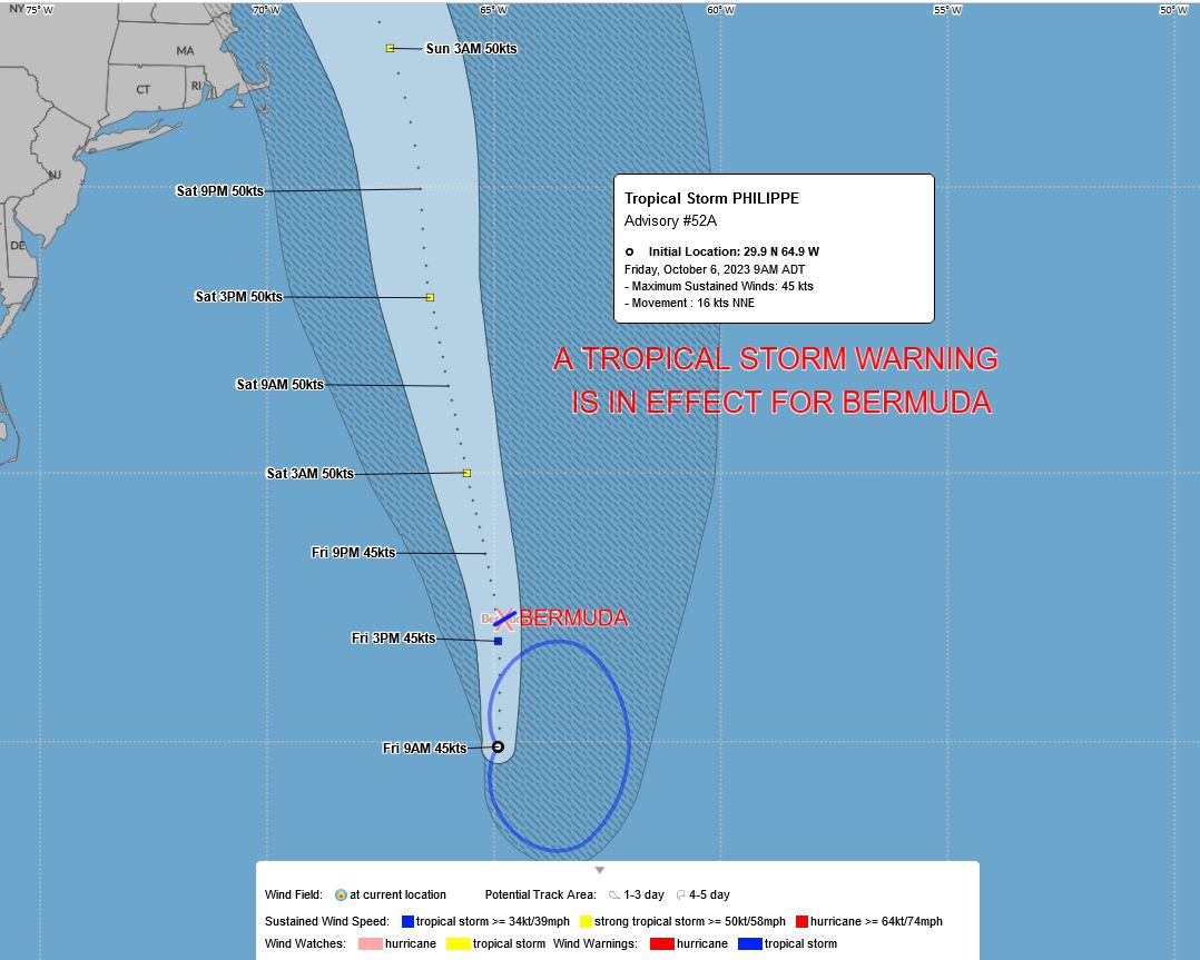
TROPICAL STORM CENTER LOCATED NEAR 29.5N  65.3W AT 06/0900Z
POSITION ACCURATE WITHIN  30 NM

PRESENT MOVEMENT TOWARD THE NORTH-NORTHEAST OR  15 DEGREES AT  16 KT

ESTIMATED MINIMUM CENTRAL PRESSURE 1003 MB
MAX SUSTAINED WINDS  45 KT WITH GUSTS TO  55 KT.
34 KT.......150NE 150SE   0SW   0NW.
12 FT SEAS..180NE 200SE   0SW  90NW.
WINDS AND SEAS VARY GREATLY IN EACH QUADRANT.  RADII IN NAUTICAL
MILES ARE THE LARGEST RADII EXPECTED ANYWHERE IN THAT QUADRANT.
This is a bit contrary to the CIRA (experimental) wind field from satellite analysis that extends much farther and which includes Bermuda:

Ironically, for the nature of this storm and the strongest winds far from the center and less to the SW for this TS, a direct or near direct hit with it continuing to move ~N might mean weaker storm winds for Bermuda...
https://www.nhc.noaa.gov/text/refresh/MIATCPAT2+shtml/060853.shtml?
The NHC advisory from earlier (09 UTC) did mention "TS-force-winds" reaching Bermuda already, which I think was from the measurement around/before 05 Bermuda time not the more recent one from 07:
" Tropical-storm-force winds extend outward up to 175 miles (280 km) from the center. In the last hour, an elevated surface observing station at National Museum of Bermuda reported a sustained wind of 46 mph (74 km/h), with gusts up to 53 mph (85 km/h). "
They don't explicitly say this is from the storm (I don't know how to take this as from the storm or not) and the distance is larger than the same wind field they provide for the storm's 34kt wind field in the forecast advisory for the same time.