
Background
Another Cabo Verde cyclone, Tropical Storm Philippe (formerly 90L and Tropical Depression Seventeen), has developed a well-defined center and deep convection and is now classified as a Tropical Storm. Does it have what it takes to reach hurricane strength?
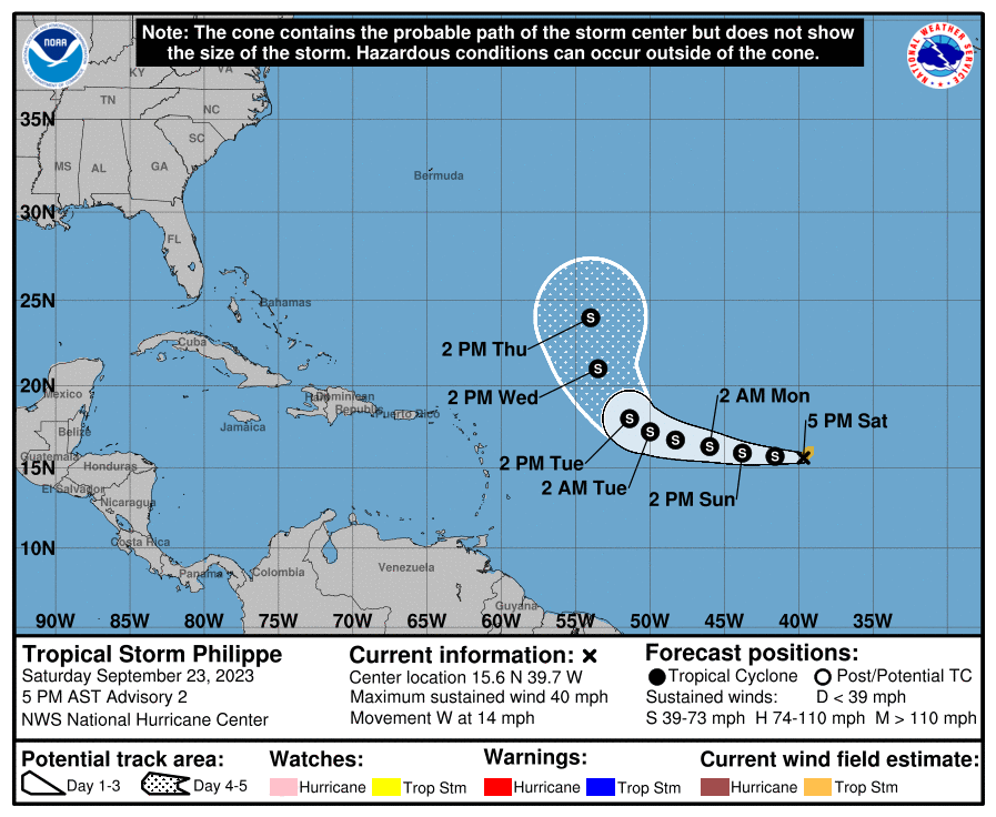
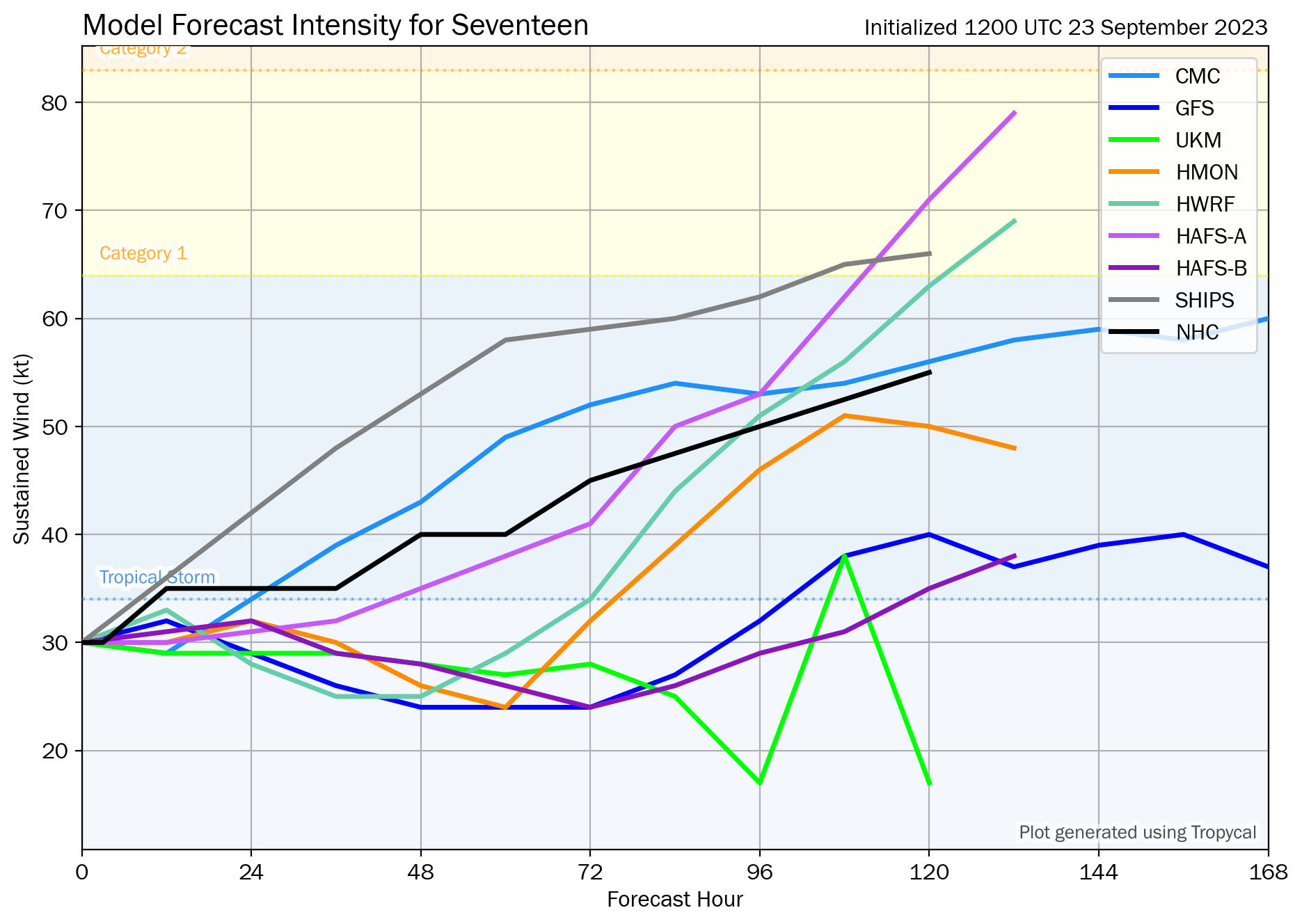
Most forecast models had predicted Tropical Depression Seventeen to at least reach Tropical Storm strength (which it did), but for now only a few predicted a peak Hurricane strength. Notably, HAFS-A, one of the newer-generation basin-focused regional models, predicted a Category 1 strength in 5 days.
Resolution Criteria
Resolves YES if Tropical Storm Philippe reaches Category 1 hurricane strength (33–42 m/s,; 64–82 kt; 119–153 km/h; 74–95 mph) during its lifetime as a tropical cyclone.
Resolves NO if the conditions for YES are not satisfied before the tropical cyclone dissipates or becomes extratropical.
Will resolve based on NHC advisories.
I will not bet on this market, but I will put Ṁ200 in as subsidy.
 1,000
1,000🏅 Top traders
| # | Trader | Total profit |
|---|---|---|
| 1 | Ṁ574 | |
| 2 | Ṁ281 | |
| 3 | Ṁ133 | |
| 4 | Ṁ104 | |
| 5 | Ṁ91 |
This market has been resolved to NO per the comment below. What a dynamic market it was! I wasn't expecting two peaks in the probability and Philippe was anything but predictable. Again, when I created this market, I did not see what happened afterwards coming. The cyclone at one point looked set for degeneration, but it not only survived but went on to impact the Leeward Islands, then Bermuda, and likely next the Eastern Seaboard as an extratropical low. For a cyclone thought to be for the fishies, it surely has accrued an impactful history by now.
Thank you very much for the participation and all the insightful comments by the traders below, they are greatly appreciated!
Philippe has become post-tropical per NHC Advisory 53, bringing an end to the tropical lifetime of this long-lived tropical storm. Since it has not reached hurricane status per NHC advisories, I am going to resolve this market as NO, shall there be no disagreement.
I am going to leave this market open for one more hour, and then I will resolve it as NO.
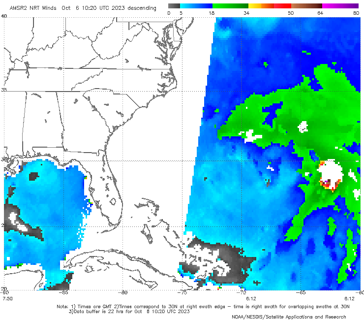
~180 n. miles east of the storm yesterday (06 UTC) there was an observation of hurricane force winds... but as this is a single data point and a day late (since it takes ~22 hours for the data to show up) they're not going to update their best track (which had it at 45 kt at the time) (it might have also been too far from the storm for attribution). I do wonder if they'll revise the best track later on this year to include this data point or not.
Philippe's structure this morning is consistent of a cyclone in the initial stages of extratropical transition. While the low-level circulation center appears better defined than yesterday at this time, most of the deep convection remains displaced well east of the center, a result likely caused by nearly 30 kt of SSW vertical wind shear. The intensity forecast presents its own challenges. Assuming that Philippe remains a distinct entity relative to the developing
non-tropical low to its west, the storm could intensify while it interacts with this upper-level trough to its west. However, its
unclear if this will prove to be a favorable trough interaction, or if this trough will ultimately just absorb the tropical cyclone
without much increase in the winds.
Regardless, after Philippe passes north of Bermuda, increasing baroclinicity will hasten its transition to an extratropical cyclone. However, FSU phase-space diagrams suggest the system could undergo a warm-seclusion-type transition, resulting in further deepening even after the system
becomes extratropical. The post-tropical cyclone is then expected to weaken once it moves inland over Maine and/or Atlantic Canada. The NHC intensity forecast continues to lie near the middle of the guidance envelope.
 48H  07/0600Z 36.7N  66.2W   50 KT  60 MPH
60H 07/1800Z 40.2N 66.7W 50 KT 60 MPH...POST-TROP/EXTRATROPLatest NHC OFCL has brought it down more.
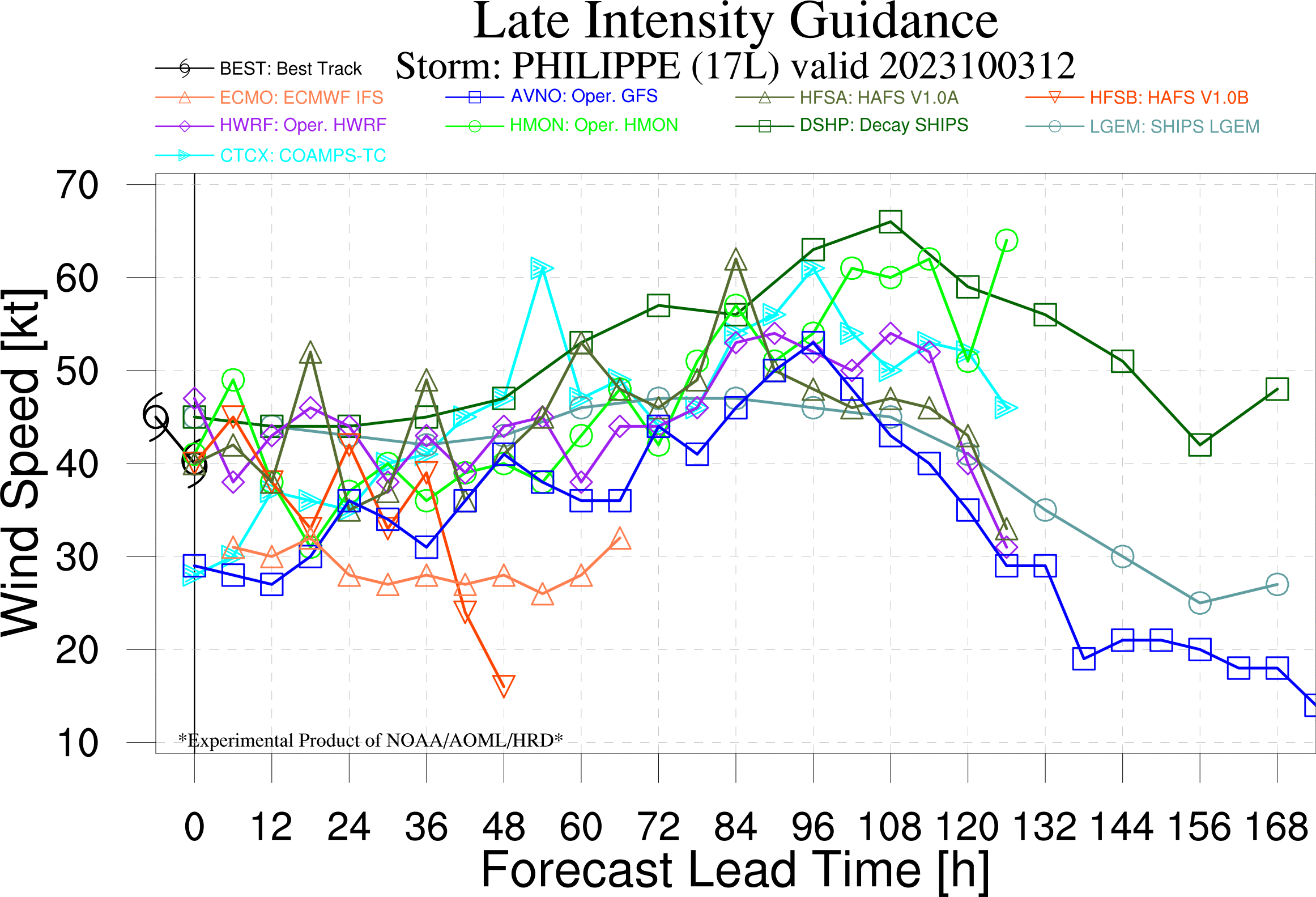
Even if there is ~ a 13% chance of the forecast being off by -20kt in 72h (when it is forecast to be 45kt), none of the models in late guidance show any possibilities greater than 65kt in this time frame to support that possibility (HMON shows winds above 60kt after 120H but phase plots show it might not be tropical at that time, as per the NHC forecast). Selling my YES shares for now, but 8% is still too low for me to buy too many NO shares.
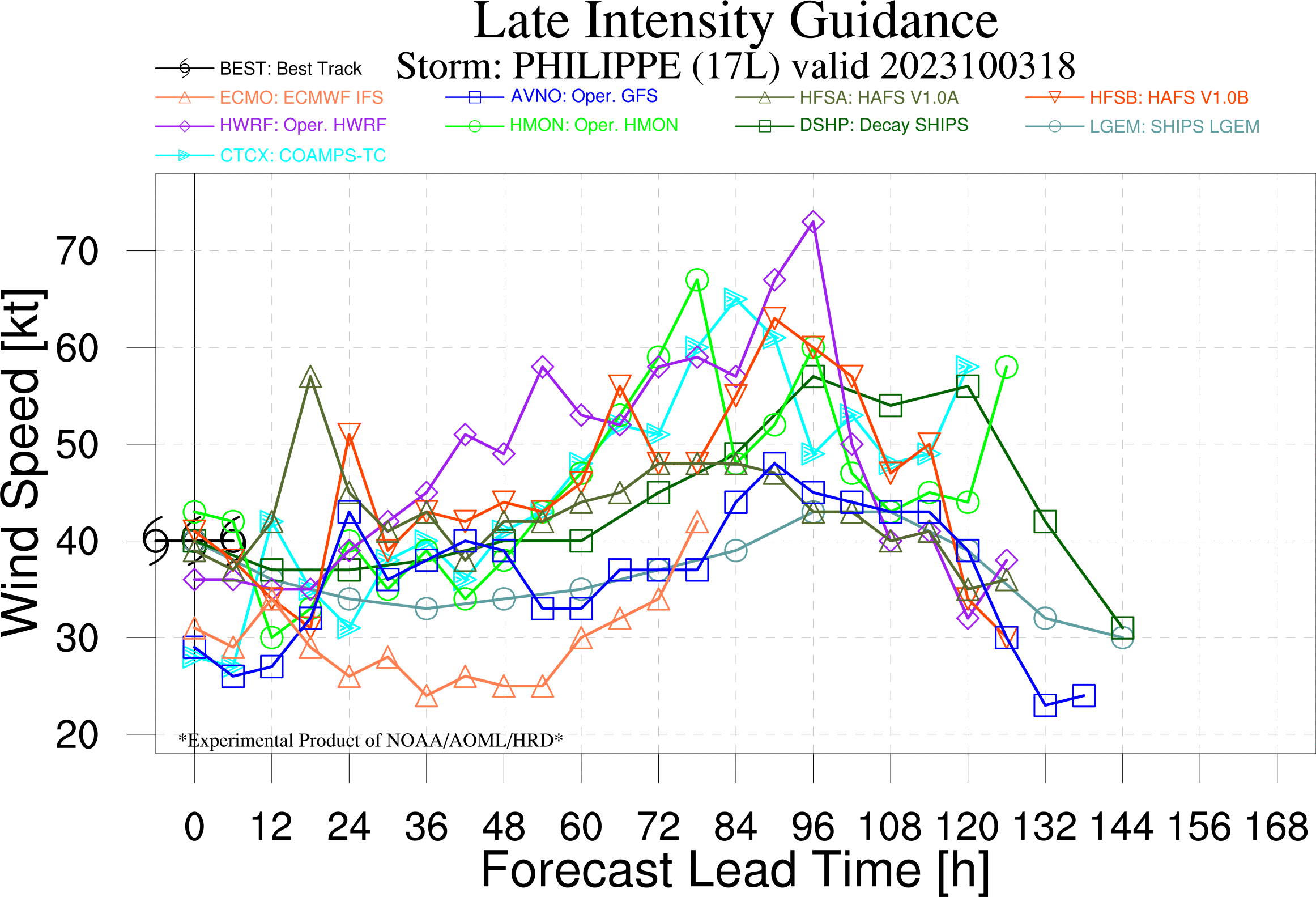
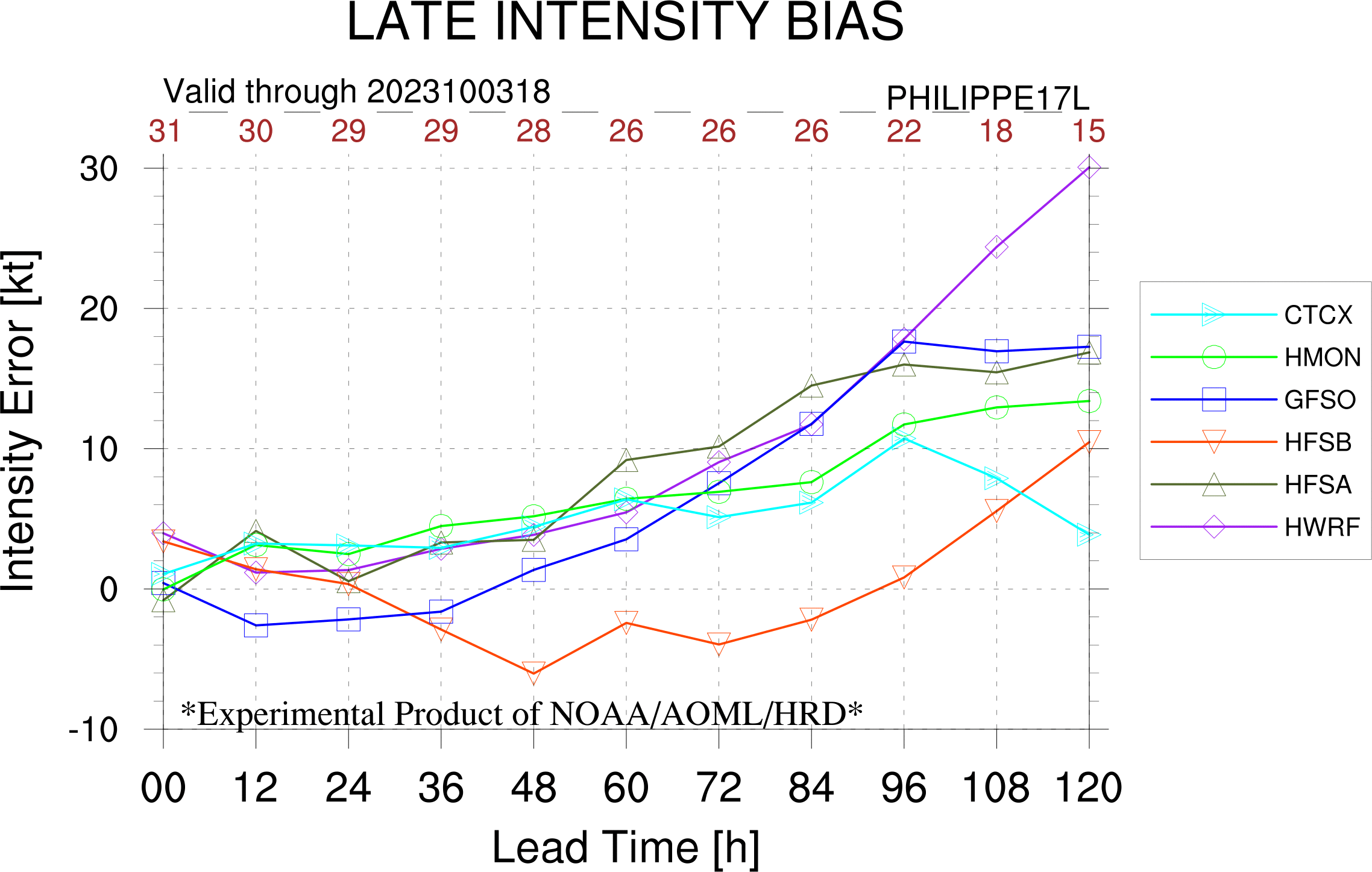
Late intensity bias shows the intensity models generally have been overestimating the intensity for this storm. Late guidance from 18Z Days 3-4 show a tight window of possibilities getting cat 1 strength, provided NHC doesn’t declare it extratropical (phase plots I looked at for that run for HMON,HWRF show it still with a symmetric warm core, but shallow). With intensity error of -15 kt for latest OFCL for 3 days out corresponds to a 18% chance historically (1989-2002) intensity will be 65kt. Reducing that uncertainty by a guess for the uncertainty about the classification of the storm as tropical or extratropical (reduce by 50% given the global models in the discussion leading to the official expectation of frontal characteristics). And reduce further by the intensity bias in the storm forecasts thus far, especially with the models mentioned, to put it below 9%.
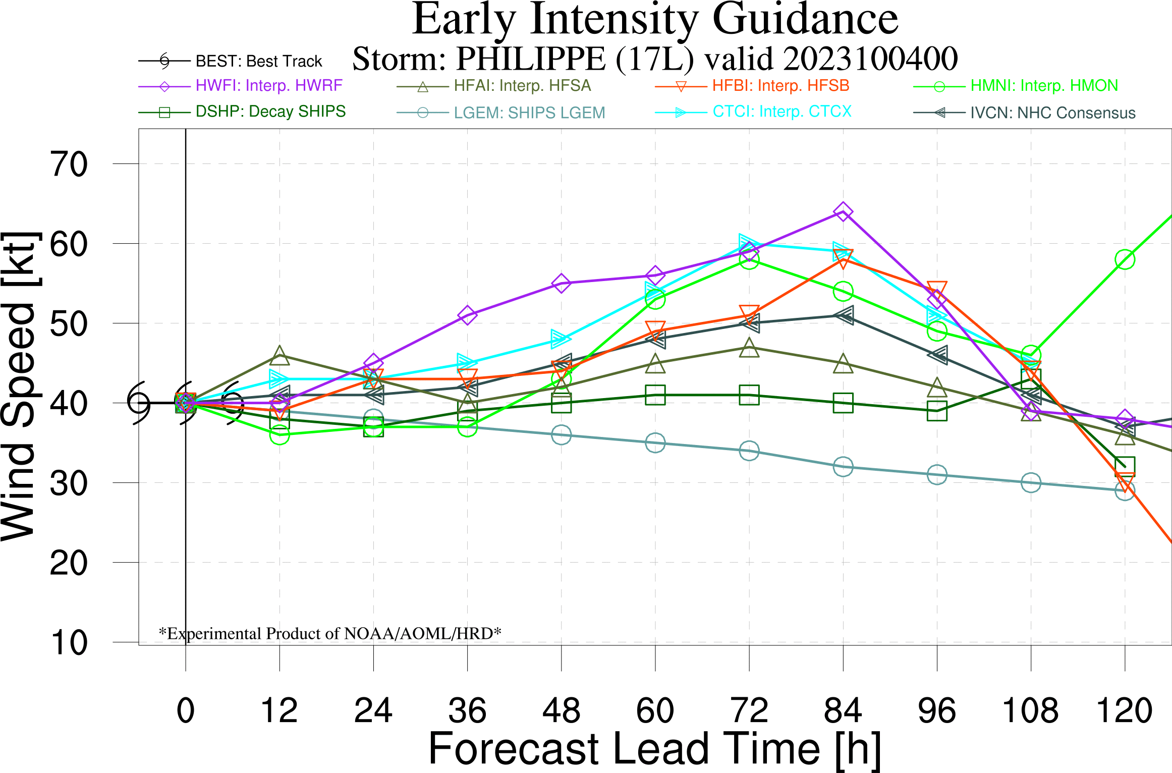
Early guidance 00z shows only HWFI barely coming near cat 1 range, with the other models (coamps and HWFI) showing more conservative numbers than the late guidance from 18z.
Little change in intensity is likely for the next couple of days while the storm remains in an environment of strong vertical wind
shear.  In 2 to 3 days, the global models suggest that Philippe could encounter a more favorable upper-tropospheric wind
environment, with more anticyclonic and diffluent upper-level winds evolving over the system.  Therefore, some strengthening is predicted in the latter half of the forecast period.  The official intensity forecast is near the high end of the model guidance, however.
FORECAST POSITIONS AND MAX WINDS

INIT  03/0300Z 17.8N  62.1W   45 KT  50 MPH
 12H  03/1200Z 18.4N  62.8W   45 KT  50 MPH
 24H  04/0000Z 19.7N  63.4W   45 KT  50 MPH
 36H  04/1200Z 21.3N  64.0W   45 KT  50 MPH
 48H  05/0000Z 23.0N  64.4W   45 KT  50 MPH
 60H  05/1200Z 24.8N  64.7W   50 KT  60 MPH
 72H  06/0000Z 26.9N  64.3W   55 KT  65 MPH
 96H  07/0000Z 31.6N  62.8W   60 KT  70 MPH
120H  08/0000Z 36.0N  60.0W   60 KT  70 MPH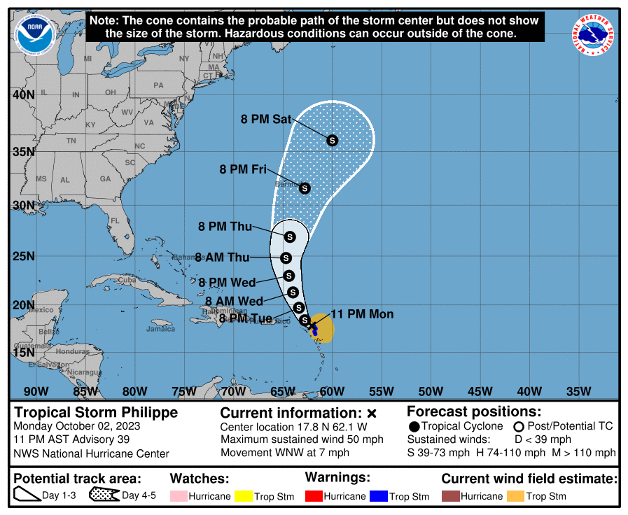
Strong northwesterly vertical wind shear is expected to prevent significant strengthening in the short term. Shear is
forecast to decrease a bit for a short period of time in the next 2 to 3 days and could allow for some strengthening.
However, almost all of the guidance is showing a less conducive environment, and
the NHC forecast reflects this trend, lying on the high end of model guidance but in line with HCCA. The uncertainty is extremely large at the end of the forecast period as some models are now showing an extratropical transition due to the mid-latitude trough, but a lot depends on how strong Philippe eventually becomes, which has clearly not been very predictable during this storm's lifetime.
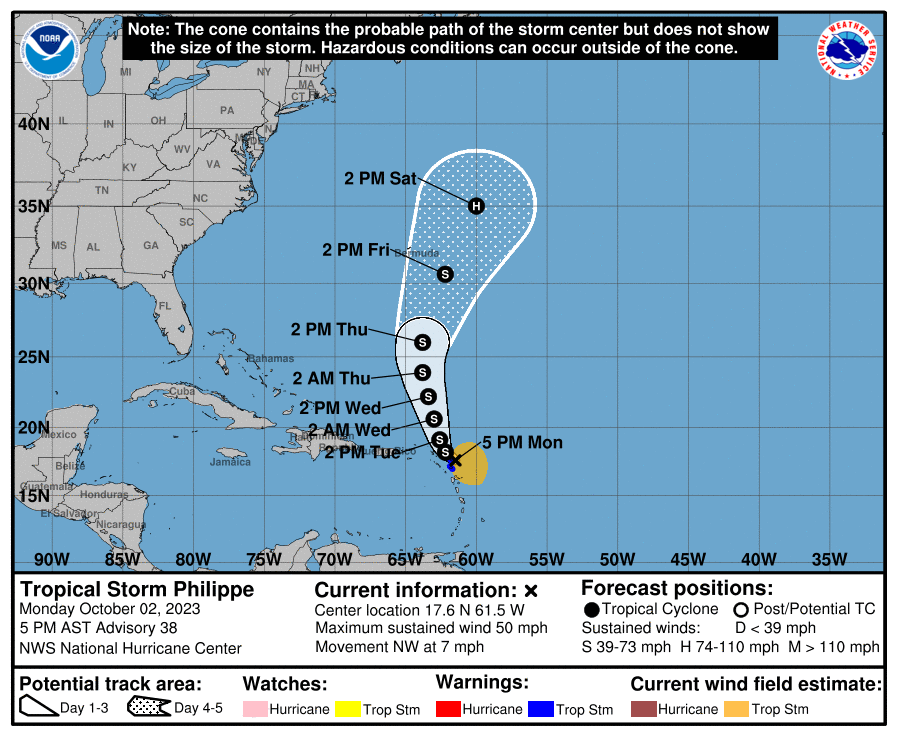
120H 07/1800Z 35.0N 60.0W 65 KT 75 MPH
@SarkanyVar Based on my old analysis of NHC OFCL errors (1989-2022) for this market it should be at least 45% using the 120H forecast where it is a hurricane (this is only using this one data point). The uncertainty is large so I set my deferral to 10%.
@parhizj 120H is already outdated, Tropical tidbits shows all models trending down in intensity forecast, I predict NHC will revise down on the next update at 11ET

NHC is still generally bullish for hurricane formation in 3-4 days.
"Strong westerly vertical wind shear is expected to prevent significant strengthening for about another 12-24 hours. After that time, Philippe is expected to encounter a more favorable upper-level wind pattern as it moves northward over the Atlantic. This should allow for steady strengthening, and much of the guidance predicts that Philippe will become a hurricane in 3 to 4 days. The NHC intensity forecast follows suit, and is a blend of the HFIP corrected consensus model and the multi-model (ICVN) intensity aid."
NHC has pushed back the time which Philippe would reach hurricane strength due to persistent west-northwesterly vertical shear...
96H 05/0600Z 25.5N 61.6W 65 KT 75 MPH
https://www.nhc.noaa.gov/archive/2023/al17/al172023.discus.032.shtml
And model forecast show that only a few models point at hurricane strength 3-4 days out.


"The atmosphere could become more favorable for strengthening after that time, and the NHC forecast now shows Philippe reaching hurricane intensity while it recurves toward the subtropical Atlantic. It's worth noting that this new forecast is still on the conservative side, and that many of the intensity models and consensus aids are at least 20 kt higher on days 4 and 5. Only the ECMWF and its SHIPS and LGEM derivatives remain on the weaker end of the scale and don't bring Philippe to hurricane strength."
60H 02/1800Z 19.2N 59.0W 65 KT 75 MPH
https://www.nhc.noaa.gov/archive/2023/al17/al172023.discus.028.shtml
