
Background
After a glut of typhoon activities during the middle of the 2023 Pacific typhoon season in August and early September, tropical cyclogenesis in the Northwestern Pacific Basin has calmed to a lull as of mid-September.
According to the Central Weather Administration of Taiwan, this is likely in part due to the ramping up of El Niño over the Pacific. However they noted that the combined effects of El Niño and warmer ocean temperatures on cyclogenesis remain uncertain.
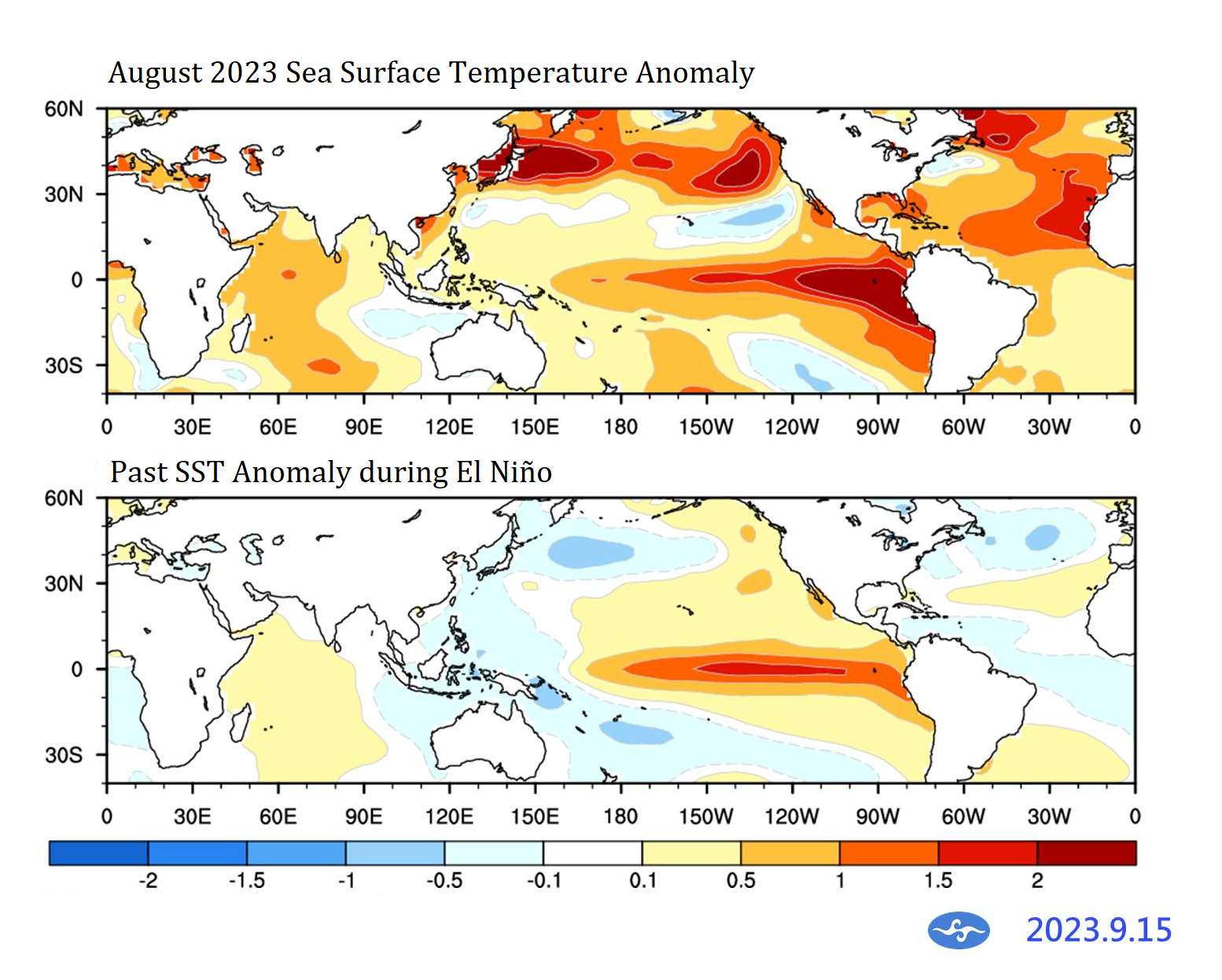
CWA still predicts the formation of tropical disturbances in the basin towards the last week of September, and does not preclude the possibility of some of these disturbances developing into tropical cyclones or typhoons.
Resolution Criteria
Resolves YES if a tropical disturbance forms in the Northwestern Pacific Basin and reaches typhoon strength (64–79 knots; 73–91 mph; 118–149 km/h) before the end of September 2023. Basin territory is defined as the area under the responsibility of the Typhoon Committee outlined by the World Meteorlogical Organisation.
Resolves NO if the conditions for YES are not satisfied by the end of September 2023.
Cross-basin tropical cyclones (e.g. Dora) do not count towards the satisfaction of the conditions for YES.
Will resolve based on JTWC data, supplemented with regional weather agencies such as CWA, CMA, HKO, JMA, KMA, etc.
I will not bet on this market, but I will put Ṁ200 in as subsidy.
 1,000
1,000🏅 Top traders
| # | Trader | Total profit |
|---|---|---|
| 1 | Ṁ516 | |
| 2 | Ṁ61 | |
| 3 | Ṁ40 | |
| 4 | Ṁ35 | |
| 5 | Ṁ29 |
People are also trading
Based on the latest JTWC wind speed reading at 55kt, as well as data from local time 8am from HKO and CWA, Koinu has not reached the required strength for YES. Therefore, the market is now resolved as NO.
Thank you very much for your participation, and especially for @parhizj for providing such informative, enriching and detailed analyses of potential candidates along the way!
The market has now closed. At 1500Z / GMT+8 11:00pm, JTWC still denotes Koinu as a Tropical Storm, thus not fulfilling the conditions for YES outlined in the description. Weather agencies in Taiwan and Hong Kong are still showing Koinu as a TS / TS-equivalent, though they are data from local time 8pm on the 30th.
As no objection to the original closing time has been noted so far, I am leaning towards keeping with the closing time as the original one, and treat the closing time as cut-off time for the criterion. I will seek data points nearest to this time for judgment, though so far the resolution is apparently going to be NO.
I am going to wait until morning on October 1 in the region (approximately 6-8 hours later) for the regional agencies report the next tick of data. Meanwhile, you are still welcome to give comments regarding the resolution.
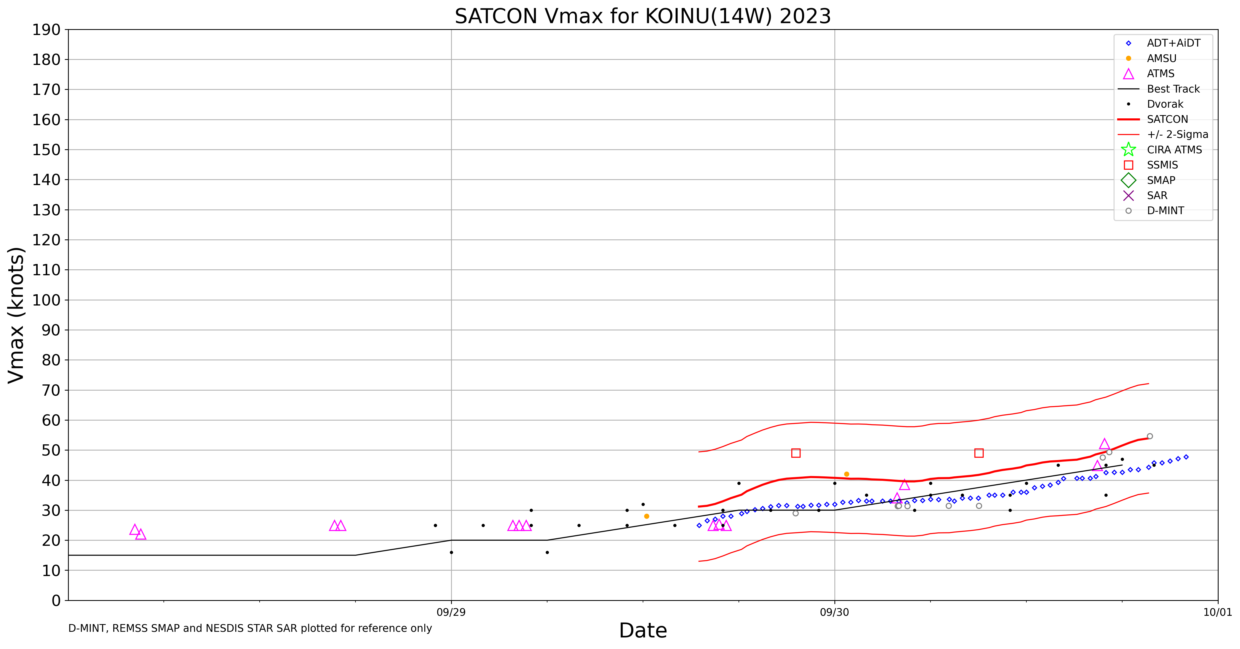
Last JTWC&JMA (21Z updates) have the most recent observed intensity as 45kt. I found a SMAP measurement of ~50kt earlier today. Looks like the wind speeds might be estimated as high as 50-60 kt range for 00Z, as SATCON has it at about ~55kt for the moment and it is trending upwards (multiplatform experimental CIRA has it at 50kt).
The next JTWC warning with intensity numbers is in ~4 hours (03Z).
@parhizj CWA and HKO at local times 8am are still reporting TS strength, but yes, I am going to wait for the next JTWC warning in about an hour for full clarity.
@SarkanyVar Its subject to change before the warning but it looks like it might be 55kt from the tcvitals
https://hurricanes.ral.ucar.edu/repository/data/bdecks_open/2023/bwp142023.dat
WP, 14, 2023100100, , BEST, 0, 174N, 1295E, 55, 991, XX, 34, NEQ, 75, 100, 95, 40, 1006, 330, 35, 0, 0, W, 0, X, 315, 8, KOINU, M, , , , , , , TCGP EXTRA DATA, WP142023, JTWC, NCEP_TCVITALS, @SarkanyVar It's out now: 55kt
https://www.metoc.navy.mil/jtwc/products/wp1423web.txt
Forecast to become a hurricane in 12 hours. 😅 Looks like that RI concern I had from earlier was pretty close and warranted if they are forecasting a typhoon in 12 hours:
WTPN31 PGTW 010300
MSGID/GENADMIN/JOINT TYPHOON WRNCEN PEARL HARBOR HI//
SUBJ/TROPICAL STORM 14W (KOINU) WARNING NR 007//
RMKS/
1. TROPICAL STORM 14W (KOINU) WARNING NR 007
   01 ACTIVE TROPICAL CYCLONE IN NORTHWESTPAC
   MAX SUSTAINED WINDS BASED ON ONE-MINUTE AVERAGE
   WIND RADII VALID OVER OPEN WATER ONLY
    ---
   WARNING POSITION:
   010000Z --- NEAR 17.4N 129.5E
     MOVEMENT PAST SIX HOURS - 320 DEGREES AT 08 KTS
     POSITION ACCURATE TO WITHIN 030 NM
     POSITION BASED ON CENTER LOCATED BY SATELLITE
   PRESENT WIND DISTRIBUTION:
   MAX SUSTAINED WINDS - 055 KT, GUSTS 070 KT
   WIND RADII VALID OVER OPEN WATER ONLY
   RADIUS OF 050 KT WINDS - 010 NM NORTHEAST QUADRANT
                            035 NM SOUTHEAST QUADRANT
                            020 NM SOUTHWEST QUADRANT
                            010 NM NORTHWEST QUADRANT
   RADIUS OF 034 KT WINDS - 075 NM NORTHEAST QUADRANT
                            100 NM SOUTHEAST QUADRANT
                            095 NM SOUTHWEST QUADRANT
                            040 NM NORTHWEST QUADRANT
   REPEAT POSIT: 17.4N 129.5E
    ---
   FORECASTS:
   12 HRS, VALID AT:
   011200Z --- 18.5N 128.7E
   MAX SUSTAINED WINDS - 065 KT, GUSTS 080 KT
   WIND RADII VALID OVER OPEN WATER ONLY
   RADIUS OF 064 KT WINDS - 000 NM NORTHEAST QUADRANT
                            010 NM SOUTHEAST QUADRANT
                            000 NM SOUTHWEST QUADRANT
                            000 NM NORTHWEST QUADRANT
   RADIUS OF 050 KT WINDS - 020 NM NORTHEAST QUADRANT
                            020 NM SOUTHEAST QUADRANT
                            040 NM SOUTHWEST QUADRANT
                            020 NM NORTHWEST QUADRANT
   RADIUS OF 034 KT WINDS - 060 NM NORTHEAST QUADRANT
                            120 NM SOUTHEAST QUADRANT
                            130 NM SOUTHWEST QUADRANT
                            040 NM NORTHWEST QUADRANT
   VECTOR TO 24 HR POSIT: 325 DEG/ 06 KTS
---@parhizj Koinu is a typhoon now at 09Z. So close!
TYPHOON 14W (KOINU) WARNING NR 008
   UPGRADED FROM TROPICAL STORM 14W
   01 ACTIVE TROPICAL CYCLONE IN NORTHWESTPAC
   MAX SUSTAINED WINDS BASED ON ONE-MINUTE AVERAGE
   WIND RADII VALID OVER OPEN WATER ONLY
    ---
   WARNING POSITION:
   010600Z --- NEAR 17.9N 129.0E
     MOVEMENT PAST SIX HOURS - 315 DEGREES AT 07 KTS
     POSITION ACCURATE TO WITHIN 015 NM
     POSITION BASED ON CENTER LOCATED BY A COMBINATION OF
     SATELLITE AND RADAR
   PRESENT WIND DISTRIBUTION:
MAX SUSTAINED WINDS - 065 KT, GUSTS 080 KTThere are still about 7 hours till the closing of this market. I originally set this to adhere to the end of October in the NW Pacific according to the GMT+8 timezone.
But due to the possible uncertainties with Koinu's development which can potentially affect the market resolution, I think there is a need to clarify whether the traders agree or disagree that:
1. The market trading should be closed according to the original closing time, or whether it should be extended until the end of October in every part of the world.
2. The cut-off time for the resolution criteria should be the same as the closing time, or whether it should be extended until the end of October in every part of the world.
Please kindly let me know in the comments what you think.
@SarkanyVar I don't predict the closing time offset will affect the resolution based on the current probabilities and forecast. I am still a bit confused about the closing time as it appears to other people... to me it appeared in my time zone (EDT) at midnight (+04 UTC). I think either the local timezone you mentioned (GMT+8) or UTC makes the most sense when creating the question but I am really ambivalent for this question for how you update the resolution time.
@parhizj To be honest, I never quite figured out the exact timezone specification on Manifold. A while ago for the sake of another market, I fiddled with the local settings, and I think for each individual it shows the time according to the timezone on your system, but the timezone used is not explicitly stated.
When someone sets the closing date of a market, the exact time used is most likely also set at the end of the day according to the system timezone. So if I wanted to set the market to end at Sep 30 23:59 at GMT+8, I would have to set my system to the +8 timezone first. A bit unwieldy, to be honest.
@SarkanyVar I searched the discord and it looks like it is always displayed/created according to the users time zone... so as the creator you could just add the hours to whatever your local timezone is.
For instance since my timezone is currently UTC-04 right now, if I wanted it to close at 00:00 UTC+08, I would set it at 12:00 my local time. I think I've done this for one of my own markets but I tend to forget these details. However, if you want it to resolve per a local time zone (and not just UTC offsets) then you have to be careful about things like daylight savings time.
JTWC and JMA updates still do not predict hurricane strength by resolution time, but there is a lot of uncertainty in both track and uncertainty due to the stage of development, complex scene, and uncertainty in the position and from the intensity of the storm winds.
The JTWC prognostic reasoning is interesting to read after looking at the complex scene from the imagery earlier today, quoting:
SATELLITE ANALYSIS, INITIAL POSITION AND INTENSITY DISCUSSION:
ANIMATED CIRA PROXY VISIBLE SATELLITE IMAGERY DEPICTS A COMPLEX SCENE
OF DEEP CONVECTION FRACTURED INTO TWO PRIMARY MASSES. BEST TRACKING
HAD BEEN ALONG THE SOUTHEASTERN MASS, HOWEVER IT HAS BEEN GRADUALLY
DECLINING WHILE THE CONVECTION TO THE NORTHWEST HAS BEEN IMPROVING IN
APPEARANCE. HOWEVER, BOTH APPEAR TO BE IN AN ENVELOPE OF A BROAD LOW
LEVEL CIRCULATION CENTER (LLCC). THE FOOTPRINTS OF THE MOST RECENT
ASCAT PASSES MISSED THE LLCC, BUT SUGGEST EITHER AN ELONGATED LLCC, OR
THE POSSIBILITY OF TWO DISTINCT LLCCS. NO OTHER RECENT MICROWAVE
IMAGERY IS AVAILABLE TO HELP REFINE THE INITIAL POSITION, WHICH WAS
ASSESSED WITH LOW CONFIDENCE BASED ON THE LARGER LOW LEVEL BANDING
OBSERVED IN THE PROXY VISIBLE IMAGERY, AND SERVES AS A CENTRAL POINT
OF THE SCENARIOS DESCRIBED ABOVE. THIS POSITION IS IN AGREEMENT WITH
THE GFS AND ECMWF ANALYZED CENTERS. ALTHOUGH THE ASCAT PASSES INDICATE
THE PRESENCE OF 35 KNOT WINDS, THESE ARE UNDER THE DEEP CONVECTION TO
THE NORTHWEST AND APPROXIMATELY 100 NM FROM THE ASSESSED CENTER. THE
INITIAL INTENSITY WAS ASSESSED AT 30 KNOTS GIVEN THE OVERALL POOR
ORGANIZATION OF THE LOW LEVEL VORTEX AND IN AGREEMENT WITH AGENCY
DVORAK FIXES FROM T1.5 TO T2.0, AS WELL AS AVAILABLE OBJECTIVE
INTENSITY ESTIMATES. CIMSS WIND SHEAR ESTIMATES ARE GENERALLY
FAVORABLE AT 10 TO 15 KNOTS. TD 14W IS TRACKING WESTWARD UNDER THE
INFLUENCE OF MID-LEVEL SUB-TROPICAL RIDGING (STR) TO THE NORTH, WITH
MODERATE EQUATORWARD OUTFLOW.
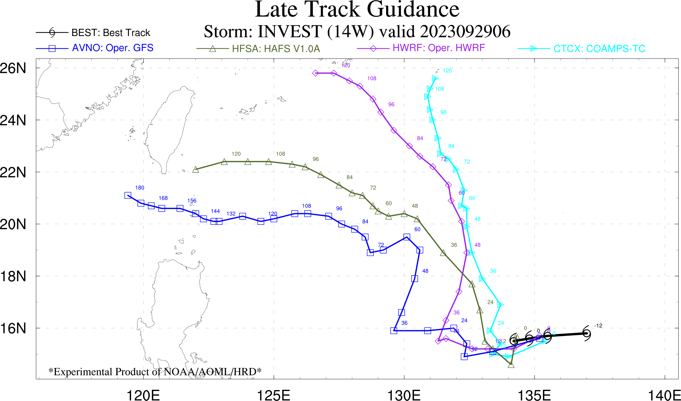
Updates to CWA, JMA, and JTWC forecasts show nothing warranting concern for this question
As mentioned, model guidance from 00z shows the increased agreement in the models and intensity below 60 kt by resolution time.

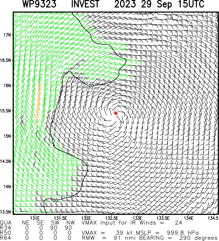
Edit: Looking at the late guidance from 06 it is roughly on schedule actually for TS intensity as some of the models do show speeds that high (the time resolution isn't that high). Timestamp for the measurement of ASCAT is 13:02 UTC and the models other than AVNO (GFS) do have it at TS intensity at around time...
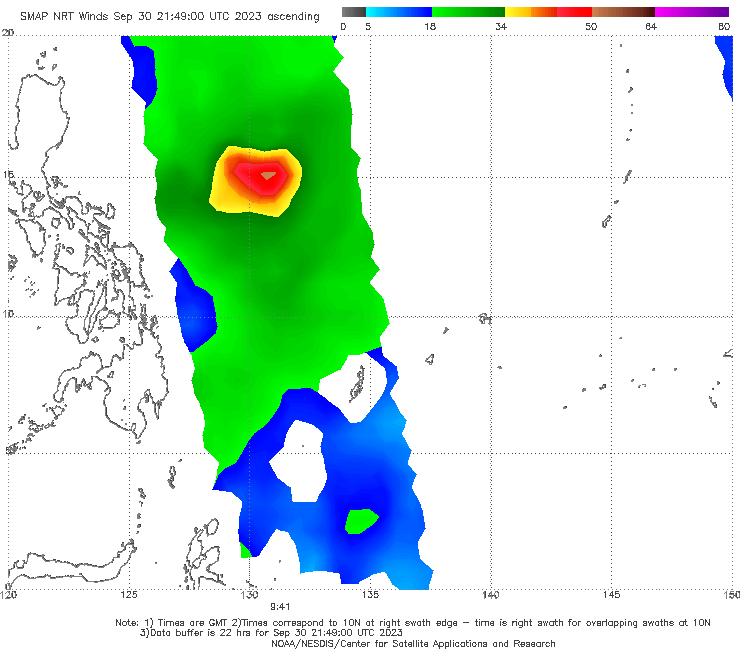
recent partial ASCAT shows some 35-40 kt winds
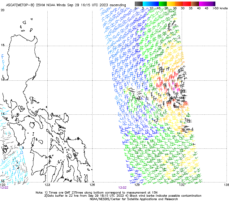
CIRA (experimental) satellite product puts it it at 39kt
CIMSS now has RI probabilities for 14W
https://tropic.ssec.wisc.edu/real-time/ai-ri/wp142023_history.html
4% for AI-RI, and 15% for AI-RI Consensus for RI-36H +45 kt (from 12UTC of 25kt to push it into 70kt by Oct. 1 00 UTC) (nothing more fine grained than that for now). This gives me some relief that the market probability isn't too far off as compared to the previous CIRA RI probabilities.
Per JMA, now TS Koinu (35 kt)
https://www.jma.go.jp/bosai/map.html#6/20.231/125.969/&typhoon=TC2316&contents=typhoon&lang=en
😦
Latest RIPA consensus (CIMSS) shows some slightly possibilities for resolving YES: 18UTC + 36 hours (Oct 1, 06 UTC). It is useful to reference the paper for RIPA in this case (https://journals.ametsoc.org/view/journals/wefo/33/3/waf-d-18-0012_1.xml), which says for the latest run of RIPA, 45kt RI, LRE has better reliability, and that in the verification, a forecast probability of 51% had an observed probability of ~30% (this is similar to the AI in RIPA consensus value of 28%). Hopefully, the next RI run for 00Z and models guidance 18Z should show the timeline clearer.
That the question closes at midnight EDT (which is Oct 1, 04 UTC) means this one data point is of concern for this question resolving YES...
Updated JMA/CWA/JTWC forecasts (18Z)... none of them show RI on this specific time frame to cat.1, so I would like to defer to them for the most likely scenario... however the JTWC has stated low confidence in the intensity forecast for the next 72 hours and forecasting RI is hard.

None of the official forecasts (JTWC, CWA, JMA) are forecasting RI, but interpreting latest RI suggests about a 30% chance of becoming a hurricane by Oct. 1, 12 UTC (using 40kt intensity RI25 and taking 30% (taking observed probability from verification bin) of predicted 57% LRE; RI-AI has it above 20%).
JTWC also just upgraded it to a TD and has forecast the intensity as a TS by Oct. 1.
https://www.metoc.navy.mil/jtwc/products/wp1423web.txt

@parhizj Intriguing punctuation to a very calm September in NW Pacific. If 14W becomes Koinu only in October (or never), it would be the least cyclonically active September in the region since CWA's records began in 1958.
@parhizj I believe so. Citing a CWA meteorologist below:
https://udn.com/news/story/7266/7473439

Rough translation:
Forecaster Lin Dingyi of CWA said that if the tropical disturbance develops into Typhoon Koinu, it is forecast to approach Taiwan or pass through the Bashi Channel next Monday and Tuesday. However, in the past, the paths of autumnal cyclones have been quite variable, and how close it is to Taiwan still depends on the strength of the Pacific high, therefore there is still great uncertainty.
Lin Dingyi also said that in previous years, there would be an average of 5 or 6 typhoons (see note) in September. So far there was only Typhoon Haikui (also see note) in early September, which is much lower than the average. If Koinu only develops in October, it means that there was only one typhoon in September this year, the lowest number since records began in 1958; if Typhoon Koinu forms within September, there would be a total of two typhoons, also the lowest number since 1986.
---
Note: CWA's terminology is a bit different from the other agencies. They call TSs 'mild typhoons' (輕度颱風), so sometimes TSs are also referred to as typhoons in Taiwan. I believe therefore the average number of 5 to 6 refer to named storms, including mild typhoons / TSs.
But here I do think within the context of records, they mean typhoons as in those reaching Cat-1 equivalent strength or above, because they seem to be discounting Yunyeung which also reached TS level. Haikui reached typhoon strength on Sep 1 so it counts as a September typhoon, just barely.
For interest, I also checked the ACE records of NW Pacific. September 2023 ACE thus far is (212.3 - 203.1) = 9.2. From historical ACE September records of NW Pacific from 1950-2021, the lowest September ACE is 5.3 in 1960, second lowest is 10.3 in 1973. So while to-be Koinu might add to the final ACE number, it still speaks to a September that is towards the very calm end of the spectrum.