Background
Tropical Storm Otis is a tropical cyclone that had formed in the Eastern Pacific south of Oaxaca, Mexico. It is forecast to become a hurricane shortly according to NHC advisories.
There has been some disagreement between models regarding the future path of Otis, with some forecasting a landfall, and the rest pointing towards a brush-by parallel to the coast. Strength forecast also varies somewhat as well between tropical storm and hurricane level winds.
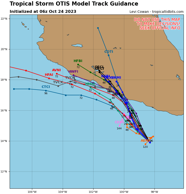
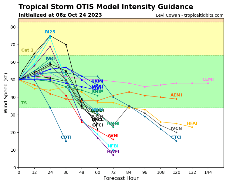
Will Otis make landfall in Mexico as a hurricane or stronger therefore, like how NHC has predicted?
Resolution Criteria
Resolves YES if Otis is deemed to have landed in any part of mainland Mexico by the Servicio Meteorológico Nacional (SMN) of Mexico, excluding all outlying islands, as a hurricane (Huracán categoría 1) or stronger. SMN's tropical storm warning page can be found here.
Resolves NO if no such information can be found from the SMN of Mexico before the dissipation, degeneration below tropical storm strength, or extratropical transition of Otis.
Will resolve based on SMN data, with supplemented data from NHC if necessary, such as if SMN has not provided an advisory on their page.
I will not bet on this market, but I will put Ṁ100 in as subsidy.
 1,000
1,000🏅 Top traders
| # | Trader | Total profit |
|---|---|---|
| 1 | Ṁ48 | |
| 2 | Ṁ31 | |
| 3 | Ṁ26 | |
| 4 | Ṁ23 | |
| 5 | Ṁ21 |
SMN declares landfall.
https://smn.conagua.gob.mx/en/pronosticos/avisos/aviso-de-ciclon-tropical-en-el-oceano-pacifico
Situación Actual:
Otis tocó tierra como huracán de categoría 5 en Acapulco, Gro a las 00:25 horas (tiempo del centro) del miércoles 25 de octubre.
Translation:
Current Situation:
Otis made landfall as a category 5 hurricane in Acapulco, Gro at 00:25 (centre time) on Wednesday, October 25.
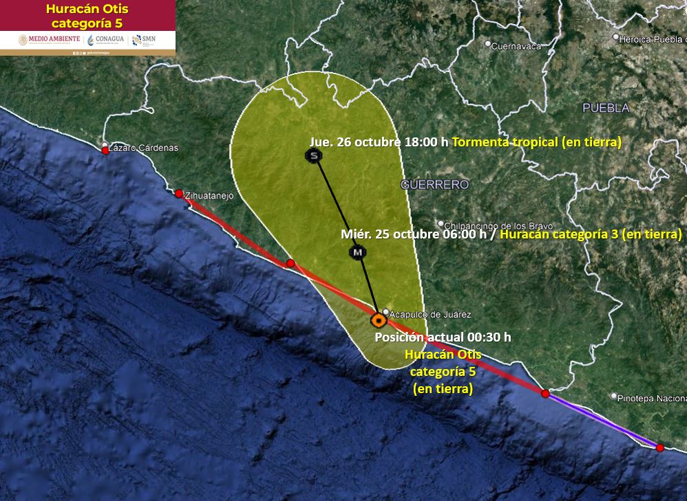
The condition for YES on this market has been reached. I will leave this market open for another hour for comments or objections. If there aren't any, I will resolve this as YES.
NHC declares landfall. First Category 5 landfall in Eastern Pacific ever recorded.
https://www.nhc.noaa.gov/text/refresh/MIATCUEP3+shtml/250626.shtml
WTPZ63 KNHC 250626
TCUEP3

Hurricane Otis Tropical Cyclone Update
NWS National Hurricane Center Miami FL       EP182023
125 AM CDT Wed Oct 25 2023

...CATEGORY 5 HURRICANE OTIS MAKES LANDFALL NEAR ACAPULCO MEXICO...

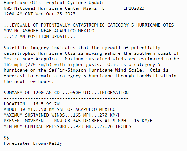
Satellite imagery indicates that Otis has made landfall near Acapulco, Mexico around 125 AM CDT (0625 UTC). The maximum sustained winds are estimated to be 165 mph (270 km/h), and the minimum central pressure is estimated at 923 mb (27.26 inches). Otis is a category 5 hurricane on the Saffir-Simpson Hurricane Wind Scale.

SUMMARY OF 125 AM CDT...0625 UTC...INFORMATION
-----------------------------------------------
LOCATION...16.8 99.9W
ABOUT 5 MI...10 KM S OF ACAPULCO MEXICO
MAXIMUM SUSTAINED WINDS...165 MPH...270 KM/H
PRESENT MOVEMENT...NNW OR 345 DEGREES AT 10 MPH...17 KM/H
MINIMUM CENTRAL PRESSURE...923 MB...27.26 INCHES

$$
Forecaster Brown/Kelly
@Eliza I am afraid not... Acapulco is a resort city with over a million people. However, from what I have been reading on Twitter in Spanish, many people simply didn't know what was coming. There was no evacuation order from the government.
Some soldiers were sent in and shelters were opened, but there simply wasn't time to evacuate, especially since the hurricane was quite compact - this means the situation would seem deceptively mild until it suddenly gets really, really bad (seems like the entire city lost electricity just now, with most webcams going offline). Also, it was midnight so many probably had gone to sleep.
Guerrero is also the second poorest state in Mexico and infrastructure is always lacking. It is built around a semicircular bay enclosed by mountainous terrain, so storm surge would be pronounced. It's a recipe for disaster.
For reference: intensity forecast from 24 hours ago vs. actual observed intensity.
https://twitter.com/burgwx/status/1716972676471021754
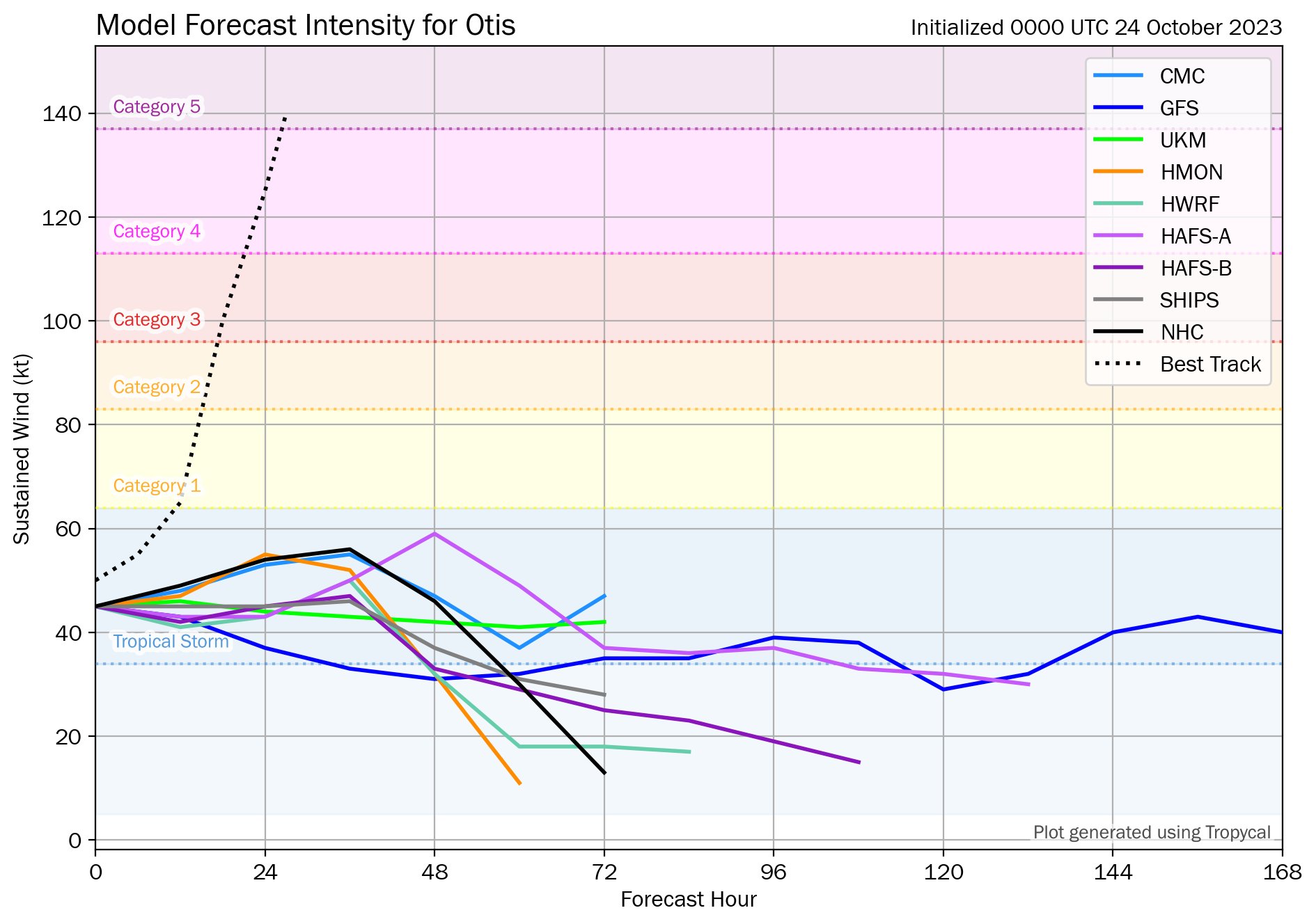
@Eliza We have made great strides in understanding rapid intensification in the recent decades, but evidently we still have a lot to do to come close to offering reliable forecast for such events.
Some possibilities include that the regional historical data are lacking (even though most models are physics-based and not statistically derived), and also regional weather observation might be less than adequate in less developed regions. For example, it might not be easy to send reconnaissance planes into the storm in a timely and frequent enough manner.
All these impact the initialisation of parameters in these forecast models and thus their accuracy. The global climatic background environment is shifting quickly and so it could lead to more uncertainties as well.
With that said, these existing forecasts are still much better than none, and they offer good forewarnings in many other cases.
https://twitter.com/philklotzbach/status/1716971756374708529
#Hurricane #Otis has intensified by 80 mph in the past 12 hours (from 65 mph to 145 mph). That's the fastest 12 hr intensification rate in the eastern North Pacific (to 180°) in the satellite era (since 1966), breaking the old record of 75 mph/12 hr set by Patricia in 2015.