
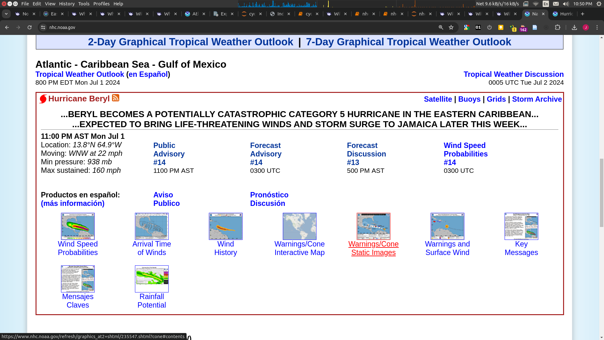
Hurricane Beryl is already category 4. Will it reach category 5?
 1,000
1,000🏅 Top traders
| # | Name | Total profit |
|---|---|---|
| 1 | Ṁ406 | |
| 2 | Ṁ290 | |
| 3 | Ṁ253 | |
| 4 | Ṁ96 | |
| 5 | Ṁ62 |
People are also trading
MAX SUSTAINED WINDS 140 KT WITH GUSTS TO 170 KT.@Gabrielle, Can resolve now per https://www.nhc.noaa.gov/text/refresh/MIATCMAT2+shtml/DDHHMM.shtml
Edit: From MSLP it's gotten weaker (941 estimated)
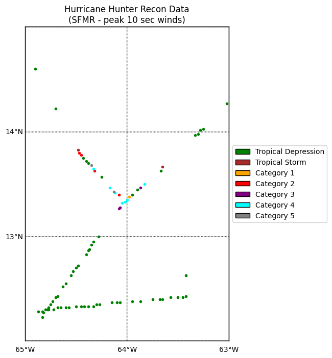
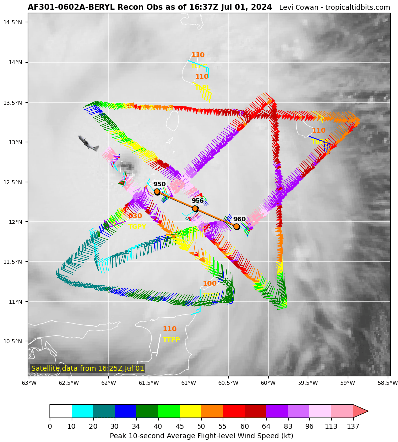
Not enough gray dots (cat 5) for 10sec winds from RECON either on SFMR or FLW:
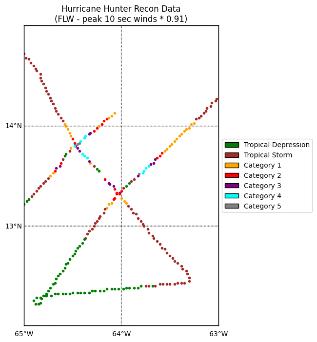
(I adjusted FLW down by standard factor of 0.91 for eyewall)
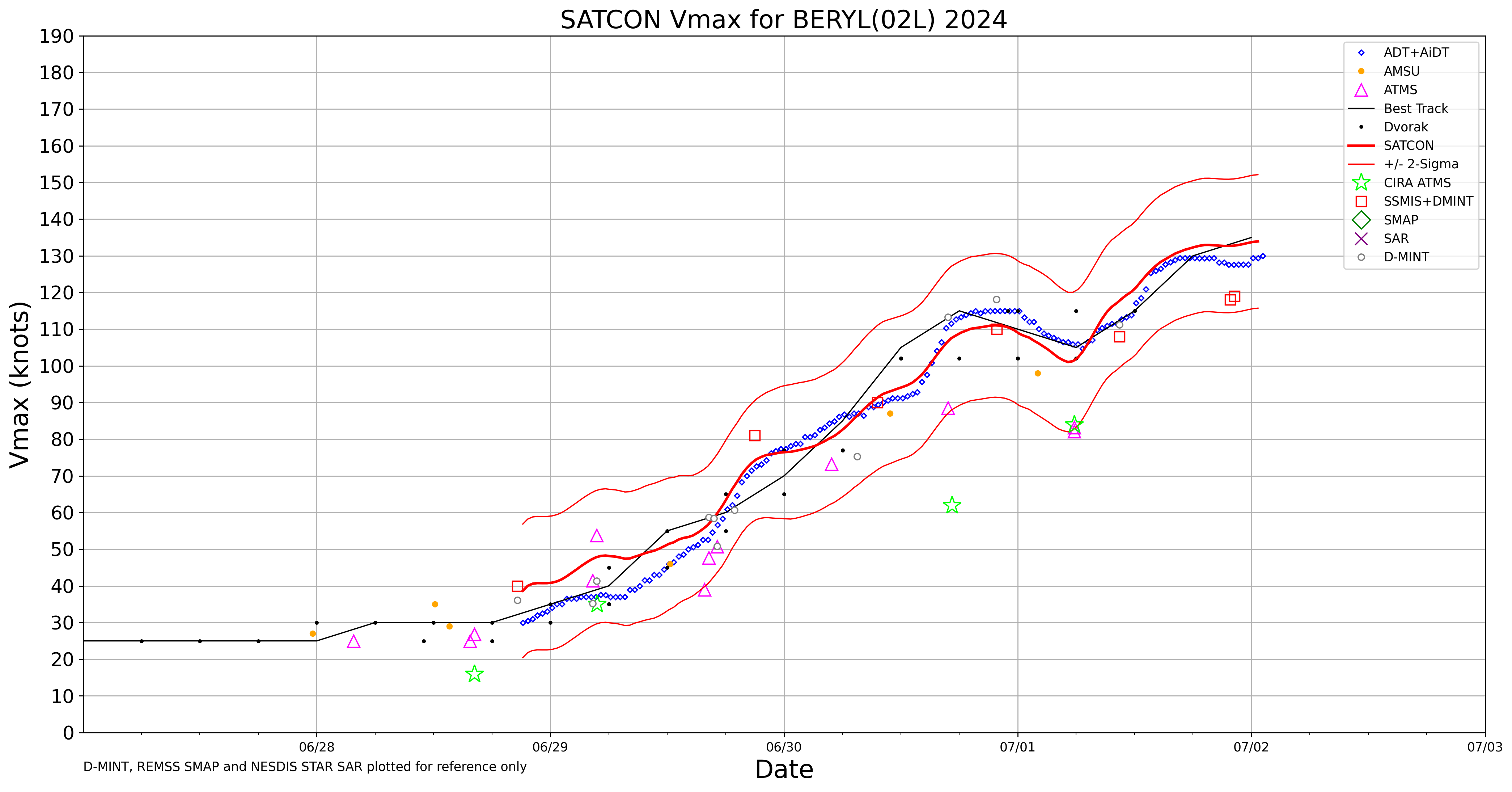
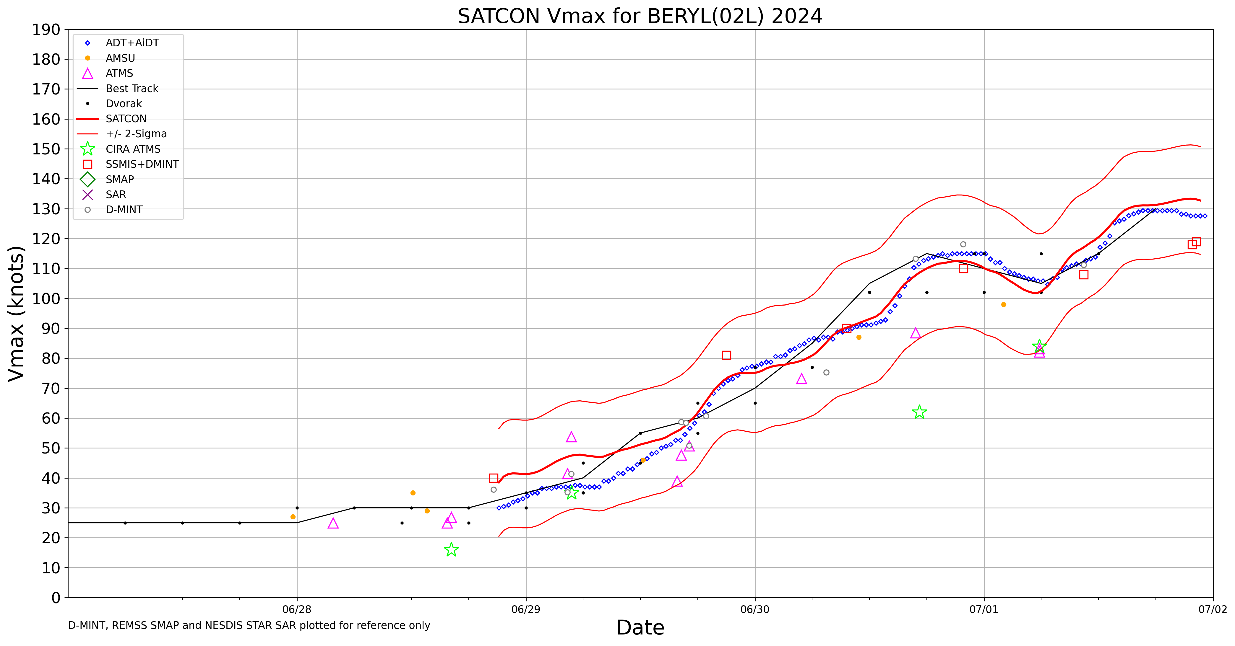
Satcon is right in the middle at 135kt:
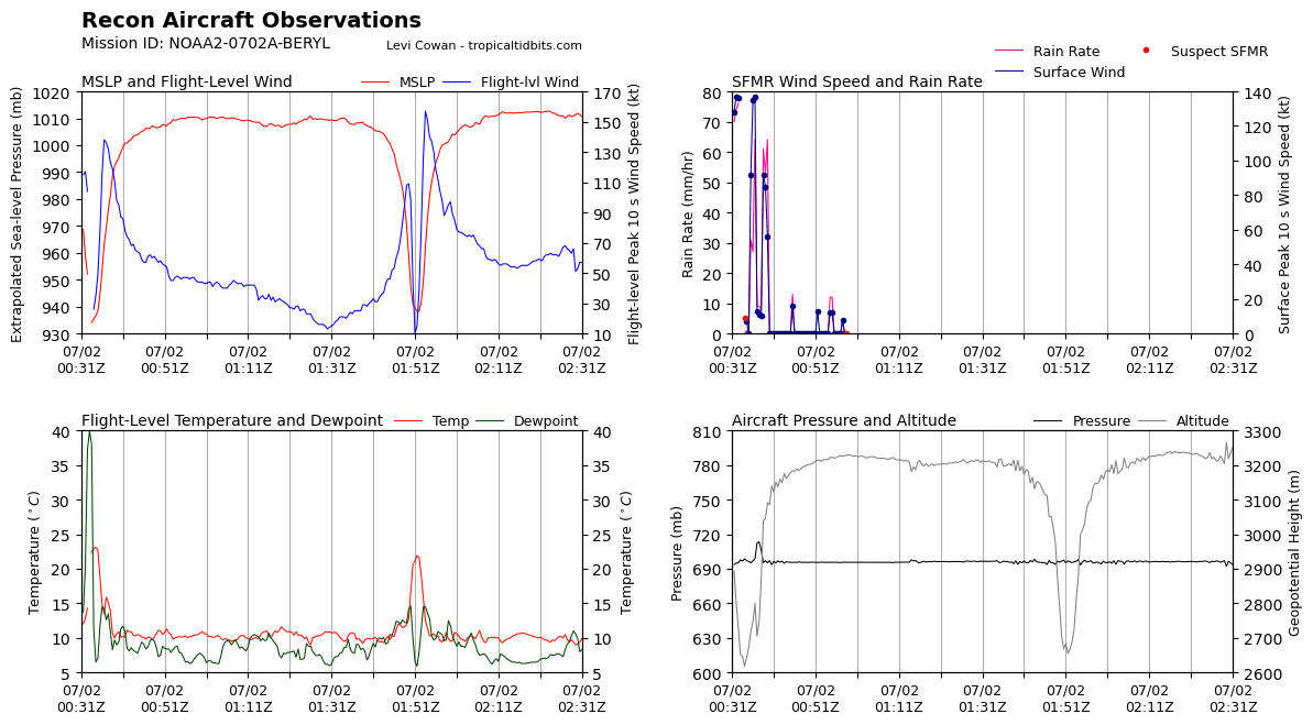
There are a few 10 sec peak winds that support it but not enough adding up for 1 minute. My charts completely filter out any suspect SFMR data only for SFMR though. (same for FLW)
Edit: the one field I don't have a notebook for is sustained 30 sec wind...
@SaviorofPlant Here is the SFMR winds > 34kt that aren't flagged:
36 kt: 17.3°, -64.42°
38 kt: 17.27°, -64.4°
37 kt: 17.25°, -64.38°
36 kt: 17.15°, -64.33°
37 kt: 17.12°, -64.32°
34 kt: 17.08°, -64.3°
34 kt: 16.73°, -64.12°
37 kt: 16.68°, -64.1°
40 kt: 16.65°, -64.07°
40 kt: 16.62°, -64.05°
40 kt: 16.58°, -64.03°
41 kt: 16.55°, -64.02°
39 kt: 16.52°, -64.0°
38 kt: 16.48°, -63.98°
37 kt: 16.43°, -63.97°
43 kt: 16.4°, -63.95°
45 kt: 16.37°, -63.92°
44 kt: 16.33°, -63.9°
38 kt: 16.3°, -63.88°
36 kt: 16.27°, -63.87°
35 kt: 16.23°, -63.85°
35 kt: 16.03°, -63.73°
38 kt: 16.0°, -63.7°
40 kt: 15.98°, -63.68°
40 kt: 15.97°, -63.65°
40 kt: 15.93°, -63.62°
43 kt: 15.92°, -63.58°
44 kt: 15.9°, -63.55°
43 kt: 15.88°, -63.53°
43 kt: 15.87°, -63.5°
39 kt: 15.87°, -63.47°
39 kt: 15.83°, -63.45°
40 kt: 15.82°, -63.42°
42 kt: 15.78°, -63.4°
50 kt: 15.77°, -63.38°
72 kt: 15.73°, -63.37°
93 kt: 15.7°, -63.35°
79 kt: 15.68°, -63.33°
56 kt: 15.65°, -63.32°
53 kt: 15.63°, -63.3°
53 kt: 15.6°, -63.28°
45 kt: 15.32°, -63.07°
44 kt: 15.28°, -63.05°
46 kt: 15.27°, -63.03°
39 kt: 13.67°, -63.65°
118 kt: 13.5°, -63.83°
98 kt: 13.47°, -63.87°
66 kt: 13.38°, -63.98°
120 kt: 13.35°, -64.0°
124 kt: 13.33°, -64.02°
117 kt: 13.32°, -64.05°
110 kt: 13.28°, -64.07°
99 kt: 13.27°, -64.08°
93 kt: 13.4°, -64.08°
128 kt: 13.42°, -64.12°
137 kt: 13.43°, -64.13°
136 kt: 13.47°, -64.17°
92 kt: 13.63°, -64.32°
135 kt: 13.65°, -64.33°
137 kt: 13.68°, -64.35°
92 kt: 13.78°, -64.45°
85 kt: 13.8°, -64.47°
56 kt: 13.83°, -64.48°
Maximum 10 sec peak SFMR wind speed: 137 knots
Location: 13.433333333333334°, -64.13333333333334°Looking into it more, I believe the rationale for the upgrade here is:
Since a hurricane's area of max winds can be relatively small, I think they don't require 60 second sustained winds - in that time the aircraft may move out of the radius of max winds
They will sometimes average SFMR and FLW estimates when they disagree. Peak SFMR is 137, peak FLW was 157 which gives a surface wind estimate of 143. That averages to 140 kt in this case
The references I read last year below (probably forgot some details) but what you said is plausible.
Edit: I forgot to mention that you can't take just FLW at 157. Got to multiply it by 0.91 for eyewall, would be 143.. But 143 averaged with 137 is 140kt. (Still only 10 sec winds though)
I just don't know their blending algorithms since it's in their head.
https://severeweather.wmo.int/TCFW/RAIV_Workshop2023/21_Analysis-Aircraft-Reconnaissance-Data_LisaBucci.pdf
https://www.nhc.noaa.gov/outreach/presentations/nhc2013_aircraftData.pdf
still an estimated MSLP of 938
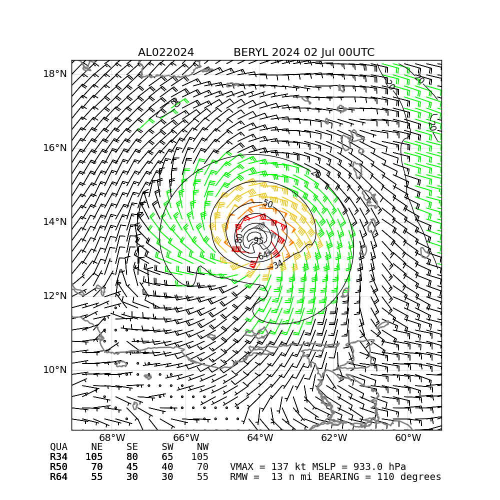
Read my comments below. It is very compact at RMW of 23 to 24km but I don’t think it’s likely cat 5 given the MSLP. The OSPO satellite wind analysis puts vmax at 137 kt.
00Z subjective dvorak from OSPO and objective dvorak place it lower. Blending it together don’t think you can go above 135 kt given the FLW.
https://www.nhc.noaa.gov/archive/2022/IAN.shtml
Ian is closest analog I could find MSLP wise in modern era… You can specifically look at Sept 28 advisories from 6am to 4 pm on Sept 28 when they strengthened it to 155 mph. They only reclassified it later when they did the reports as cat 5.
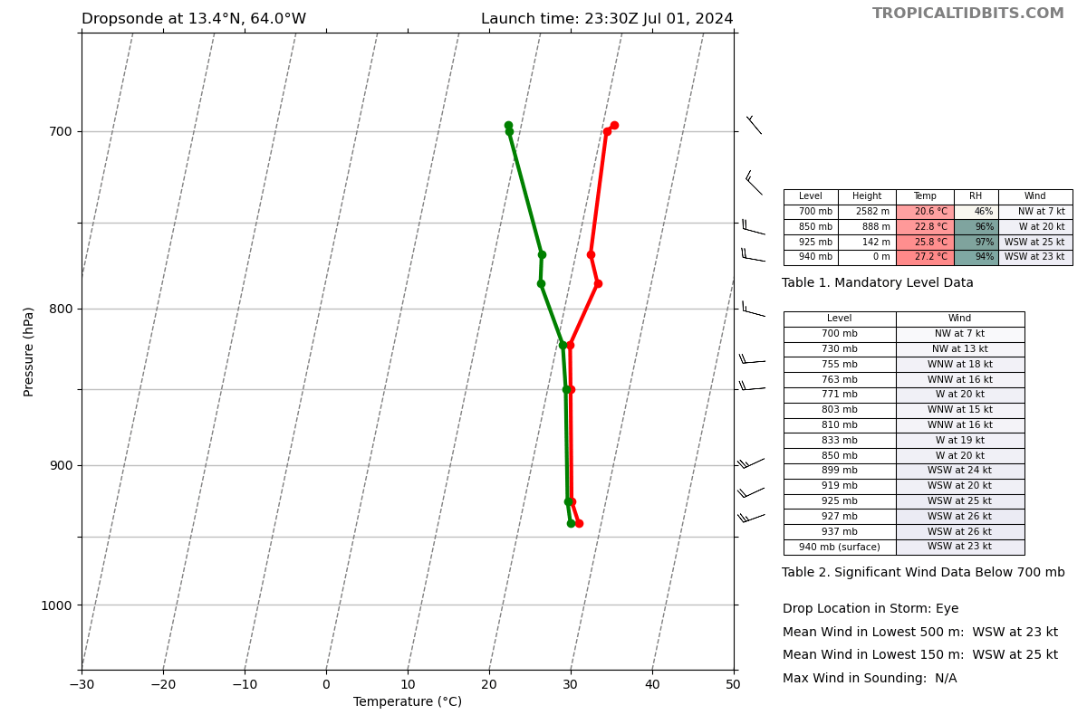
Edit They upgraded the intensity on the home page (com atcf also) to 135 kt. Their was a Dropsonde that showed 138 kt in average lower 150m but rest of Satcon blended together I dont think supports cat 5.
938 estimated MSLP by rule of thumb (940 - (23/10)) doesn’t seem strong enough for cat 5 either
Edit based on this:
https://en.m.wikipedia.org/wiki/List_of_Category_5_Atlantic_hurricanes
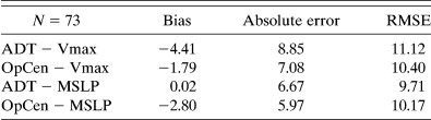
It would be in the about 5% percentile of storms of Cat 5 at MSLP of 938. This also matches the ADT estimate for MSLP
Looks like they fed 130kt into the models for the 18Z run:
AL, 02, 2024070118, 01, CARQ, 0, 128N, 623W, 130, 946, HU, 34, NEQ, 110, 100, 80, 100, 1012, 150, 10, 0, 0, L, 0, X, 290, 17, BERYL, D, Suggesting it is likely they'll raise it up to a strong cat 4 for the 5pm advisory:
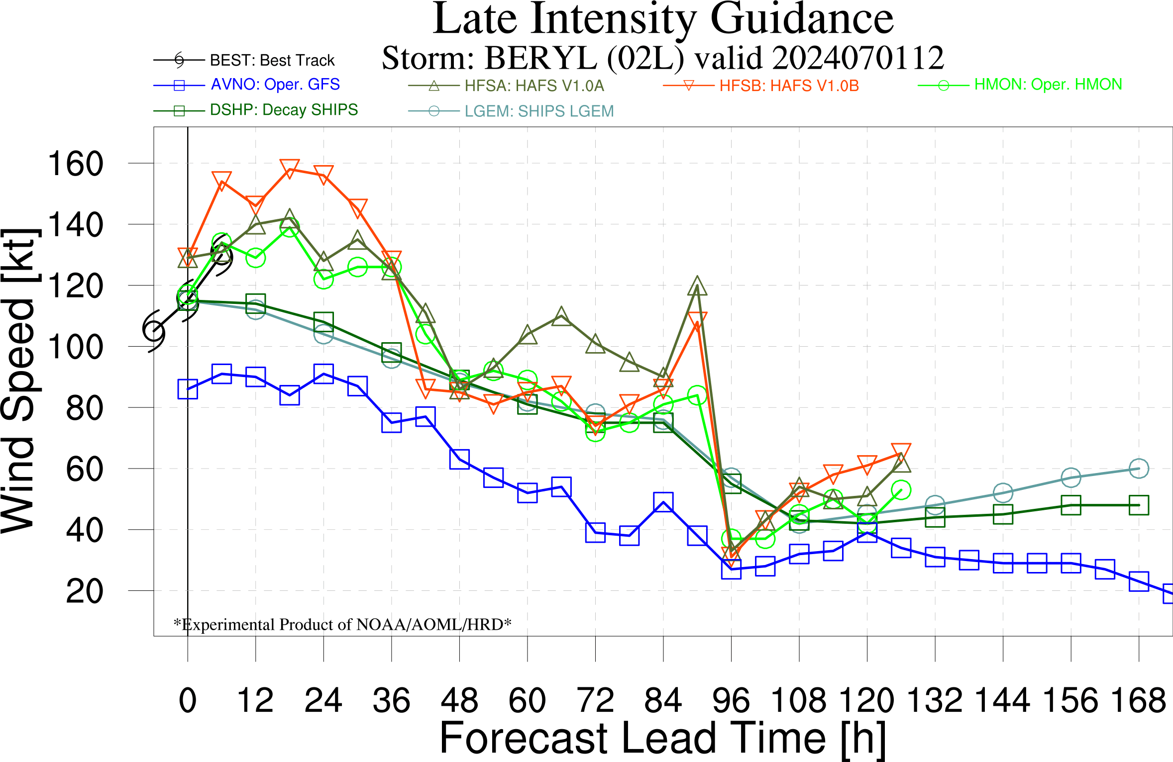
Both of the HAFS models do show extra strengthening but have been very aggressive. ADT only supports 130 kt though it does have a small negative bias:
@ScottSupak I think you betting it up to where it is, is probably just about right ....
@SaviorofPlant Don't know when the next SSMI pass is (last one was at ~10Z), but that (with DMINT) plus other objective measures like ADT provide enough objective evidence to support upgrading to cat 5 temporarily?
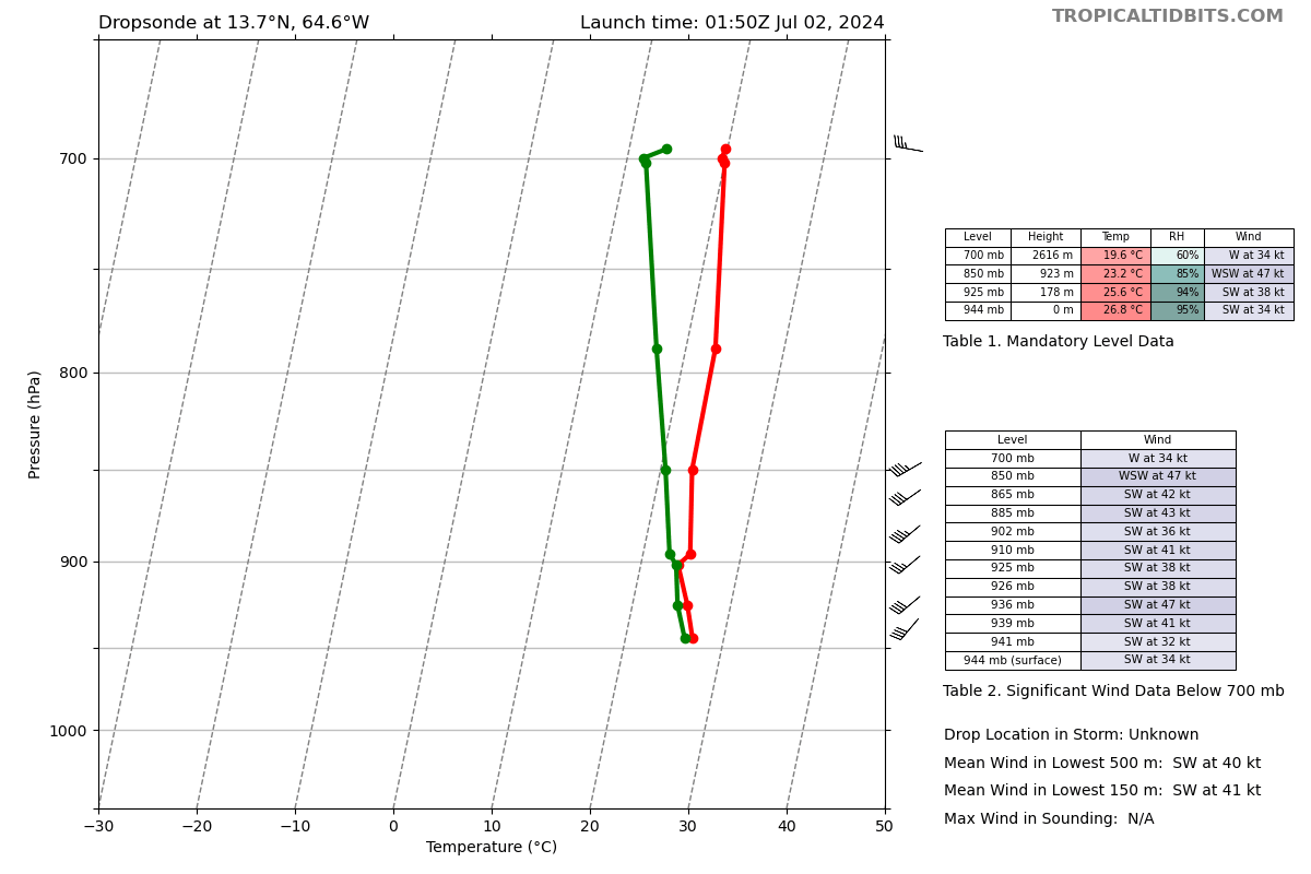
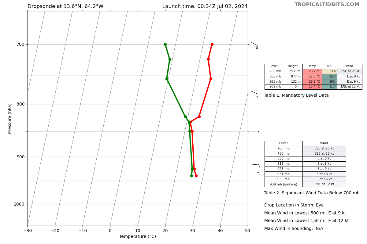
This dropsonde came in 10 mins before the 11AM advisory ... From the NHC discussion it is not obvious whether they saw it or not (since they only mention recon/intensity estimates from a couple hours prior). I'm assuming though they saw it and still kept the advisory somewhat conservatively since it is only one point in the wind field (might be cat 5 level gusts with the mean lower 500m at +140 kt):
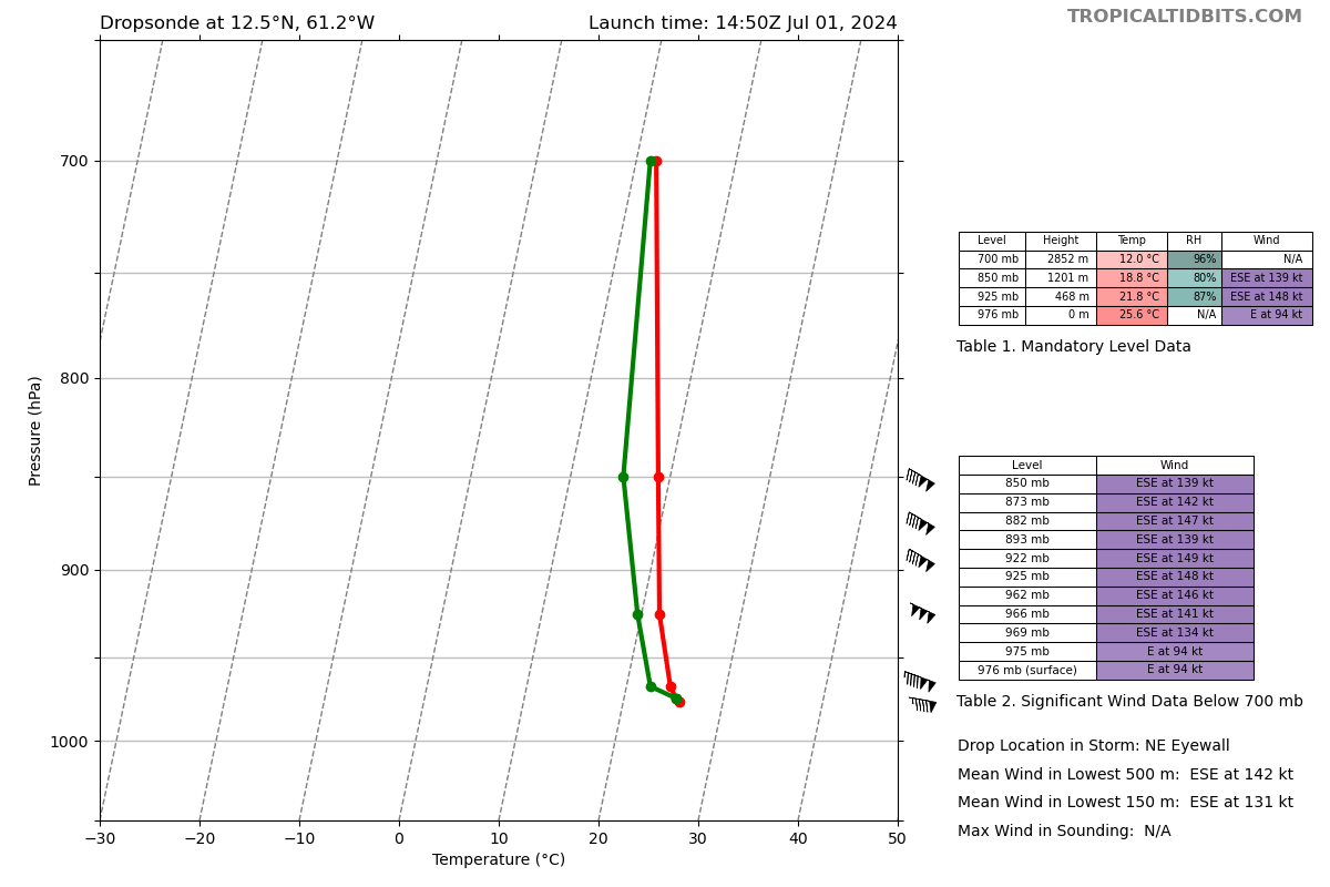
When it's available, NHC prefers using reconnaisance flights over satellite data for upgrading storms. That dropsonde alone doesn't support C5 intensity for the reasons you mentioned, and I believe most C5 upgrades in the past have required both flight-level winds around 150-160 kt and SFMR or dropsonde data supporting C5 winds at the surface.