Resolves YES per the NHC if there is a Cat III+ hurricane in the Atlantic by 09-10-2023 0z.
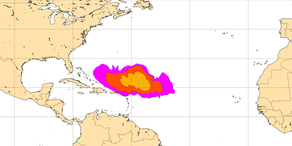
Graph shows the strike probability at 20230911 12z based on the number of ENS members (20230830 12z) that predict a hurricane (each member has equal weight). Strike probability = a hurricane will pass within a 300 km radius from a given location (purple = 5-10%, red = 10-20, organge = 20-30, yellow = 30-40) and within a time window of 48 hours of 20230911 12z.
 1,000
1,000🏅 Top traders
| # | Trader | Total profit |
|---|---|---|
| 1 | Ṁ419 | |
| 2 | Ṁ189 | |
| 3 | Ṁ131 | |
| 4 | Ṁ86 | |
| 5 | Ṁ82 |
People are also trading
Maximum sustained winds have rapidly increased to near 130 mph
(215 km/h) with higher gusts. Lee is a category 4 hurricane on the
Saffir-Simpson Hurricane Wind Scale. Additional strengthening is
expected tonight. Fluctuations in intensity are expected after
that, but Lee is forecast to remain a powerful major hurricane
well into next week.Why hello there Mr. Lee.... Let's hope this one is for the fishies, because it is one mean looking storm. ACE dump incoming. I think this has (so far) been one of the most bullish NHC forecasts ever, iirc...
It is becoming a question of when and not if rapid intensification (RI) occurs with Lee.  A well-defined outflow pattern has developed over the circulation, and there are some hints on a recent SSMI/S microwave pass that parts of an inner core are forming. There's still some notable northeasterly shear that could keep Lee in check for the next day or two, so the NHC intensity forecast will stay at a more moderate rate of intensification during that time.
All of the models decrease the shear by Friday, so RI is explicitly forecast at that time frame while Lee is moving over extremely warm waters.  The new forecast is adjusted higher than the last advisory, near the model consensus, but there's a notable contingent of guidance higher than this forecast.  There is increasing confidence on Lee becoming a very powerful hurricane by this weekend.

FORECAST POSITIONS AND MAX WINDS

INIT  05/2100Z 13.2N  41.8W   40 KT  45 MPH
 12H  06/0600Z 13.7N  43.7W   50 KT  60 MPH
 24H  06/1800Z 14.4N  46.2W   60 KT  70 MPH
 36H  07/0600Z 15.2N  48.5W   70 KT  80 MPH
 48H  07/1800Z 16.2N  51.0W   80 KT  90 MPH
 60H  08/0600Z 17.2N  53.6W   90 KT 105 MPH
 72H  08/1800Z 18.3N  56.0W  110 KT 125 MPH
 96H  09/1800Z 20.4N  60.5W  120 KT 140 MPH
120H 10/1800Z 22.2N 64.3W 125 KT 145 MPH@sarius For reference, today I learned where to find the e-deck files (https://ftp.nhc.noaa.gov/atcf/gpce/) and went back and looked at the RI intensity probabilities in experimental guidance for that bullish 5 PM forecast, and the highest probability I could find prior to it was 47%:
AL, 13, 2023090512, RI, DTOP, 72, , , 47, 65, 95, , 0, 72,
Reached 80%, 18 hours later:
AL, 13, 2023090606, RI, DTOP, 72, , , 80, 65, 120, , 0, 72,
And 93%, 18 hours after that:
AL, 13, 2023090700, RI, DTOP, 48, , , 93, 55, 125, , 0, 48,
FYI, the RI methods usually use SHIPS output (with the exception of DTOPS which uses model forecast intensities) and are described here:
https://repository.library.noaa.gov/view/noaa/47867/noaa_47867_DS1.pdf
"The guidance suite includes four models that use a subset of predictors from SHIPS to estimate the probability of rapid intensification in the next 12–72 h: the RI Operational Discriminate Analysis (RIOD), RI Operational Bayesian (RIOB), RI Operational Logistic Regression (RIOL), and the RI Operational Consensus (RIOC). A different approach is taken by the Deterministic to Probabilistic Statistical (DTOPS) model, which estimates RI probabilities using deterministic intensity model forecasts as input. These RI models are described in DeMaria et al. (2021)."
Video here: https://ams.confex.com/ams/34HURR/meetingapp.cgi/Paper/373073
The environment around the depression appears to be conducive for strengthening.  The only obvious hindering factor is light-to-moderate northeasterly shear, which should keep the intensification rate in check in the short term.  However, in two to three days, this shear is forecast to relax with an upper-level ridge building near the cyclone, and the system should be moving over record-warm waters of near 30 deg C east of the Lesser Antilles (that would look more in place in the Gulf of Mexico). These factors could support rapid intensification by the end of the week, although it too early to determine exactly when this might occur until a better-defined inner core forms.  The NHC intensity forecast is extremely bullish for a first forecast, but remarkably lies below the intensity consensus.  All indications are that the depression will become a strong hurricane by the end of the forecast period.

FORECAST POSITIONS AND MAX WINDS

INIT  05/1500Z 12.5N  40.2W   30 KT  35 MPH
 12H  06/0000Z 12.8N  42.1W   40 KT  45 MPH
 24H  06/1200Z 13.6N  44.7W   50 KT  60 MPH
 36H  07/0000Z 14.4N  47.2W   60 KT  70 MPH
 48H  07/1200Z 15.3N  49.7W   70 KT  80 MPH
 60H  08/0000Z 16.2N  52.2W   80 KT  90 MPH
 72H  08/1200Z 17.3N  54.7W   95 KT 110 MPH
 96H  09/1200Z 19.4N  59.1W  115 KT 130 MPH
120H  10/1200Z 21.5N  63.5W  120 KT 140 MPH
Note that this market ends at 10/0000z. I will use the closest NHC advisory issued before and after this time to track the storm's strength. I will also be tracking the storm myself and keep this market updated as we draw closer to market close.
@sarius Now TS Lee
https://www.nhc.noaa.gov/text/refresh/MIATCMAT3+shtml/052049.shtml?
OUTLOOK VALID 09/1800Z 20.4N 60.5W
MAX WIND 120 KT...GUSTS 145 KT.
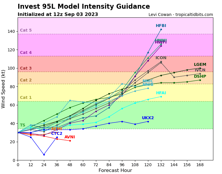
Going by the intensity forecast alone, 96 hours out the error would have to be 25kt to make it less than a cat 3:
The market should be about 85% by that alone. As there are not a lot of other major variables that I’m aware of, such as going over land (all the tracks now show it not hitting the leeward islands), I understand it should be higher than that but I don’t know how I could put it at 90% ( have no model for incorporating that info)
According to the last advisory, since in ~72h it is forecast at 130kt, the margin of error is ~35 kt, so the probability is ~95% according to the above chart, matching the market probability nicely.
@CollectedOverSpread yep, I should have probably put "Will there be a major hurricane in the Atlantic between 08-31-223 and 09-10-2023?" instead.