Activity is tracked in terms of https://en.wikipedia.org/wiki/Accumulated_cyclone_energy. This Wikipedia page has a list of previous North Atlantic hurricane seasons by ACE.
If the value is 10 or more ACE away from one of the cutoff values, this market resolves in January 2025 to whatever value is listed on Wikipedia. If it is close to a cutoff, the market resolves after the reanalysis of all storms is completed (usually in April) to account for postseason adjustments in ACE.
North Atlantic sea surface temperature anomalies, which are correlated with tropical cyclone activity, are currently (as of February 20) extremely high and can be tracked here: https://www.tropicaltidbits.com/analysis/ocean/cdas-sflux_ssta_atl_1.png
The last ten years had the following activity:
Below normal: 2014, 2015
Near normal: 2022
Above normal: 2016, 2018, 2019, 2021, 2023
Hyperactive: 2017, 2020
The least active season in recorded history was 1914, while the most active season was 1933.
See also my El Nino / La Nina market for hurricane season: https://manifold.markets/SaviorofPlant/will-it-be-el-nino-la-nina-or-neith. El Niño tends to suppress Atlantic tropical cyclone activity, while La Niña tends to enhance it.
Possible clarification from creator (AI generated): The market will resolve based on reanalysis in spring 2025 if the ACE value is close to the hyperactive cutoff.
🏅 Top traders
| # | Name | Total profit |
|---|---|---|
| 1 | Ṁ878 | |
| 2 | Ṁ284 | |
| 3 | Ṁ134 | |
| 4 | Ṁ119 | |
| 5 | Ṁ67 |
People are also trading
Current year's market is up: https://manifold.markets/SaviorofPlant/how-active-will-the-2025-atlantic-h?play=true
@SaviorofPlant You can resolve now.
Milton TCR was done today completing the season.
I have 168.28 ACE from my calculations.
Edit2: referencing colostate's ACE values this was a historically fairly large post-season upgrade in ACE for the season (168.28 - 161.7 ~= 6.6 ACE upgrade) -- perhaps 2nd largest that I have data for if my earlier calculations are correct (largest in 50 years)

Helene TCR was finished (upgraded by ~1 ACE) so only Milton is left now.
Now at a total of 143.31 ACE without Milton (which prior was 23.5).
@ChristopherRandles See description, we're close enough to the hyperactive cutoff that resolution will be based on reanalysis next spring

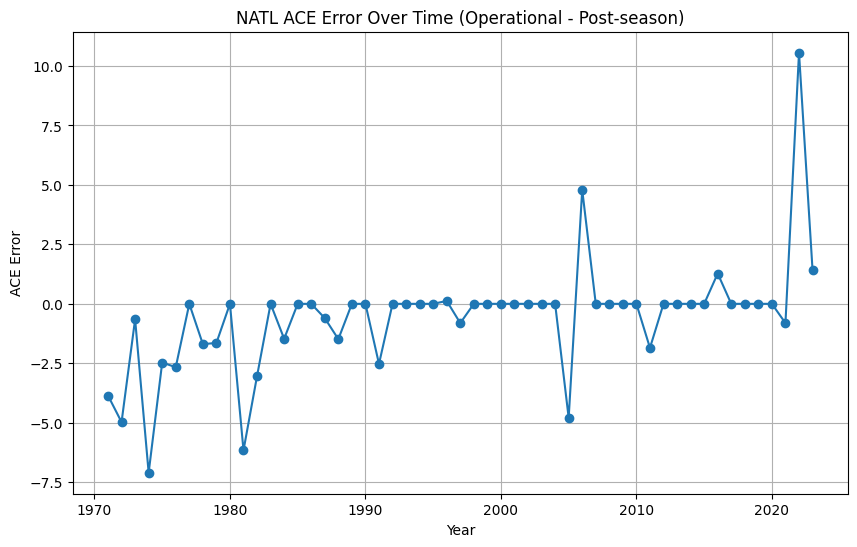
I've excluded 1970 as that is an extreme outlier (-40 ACE adjustment); some statistics on above:
Mean: -0.57
Median: 0.00
RMSE: 2.51
Standard Deviation: 2.44
Minimum: -7.10
Maximum: 10.56
Looks like post-season downgrades (with respect to ACE) are indeed rare (positive values in graph), with only 2 years out of 50+ years having significant enough downgrades. (Implying a probability of 2-5%)
Given Sara is very likely at this point (and expects to add ~ 6 ACE (or more) from EPS/00Z at this point), this further justifies me selling the remaining amount in Above Normal bin even if it ends up going to post-season (not pushing over the 10 ACE required).
@NicoDelon Why post yesterday? Today is 159.8 (now that Rafael is done…)
https://tropical.atmos.colostate.edu/Realtime/
Anyway this will go to post season (next year) most likely still at this point per resolution details…
Since I wrote that yesterday, the NHC has twice upgraded the advisory forecast for Rafael; additionally, NHC is now favoring a track more along the ECMWF models (more westerly tracks) ; these westerly tracks in EPS favor possibilities of a longer duration spent traversing the GoM instead of making landfall early on.
Unfortunately this will keep this market a virtual coin toss for the next ~ 5 days (unless the RI amount/duration is significantly off in the latest NHC forecast).
The latest advisory brings my estimate using OFCL (interpolating VMax linearly) for Rafael's storm lifetime to ~12 ACE, which would put the season ACE (barring any Sara) at 159.3.
At this point, such an estimate is going to be crude in predicting the result as it will be sensitive to even slight changes in the forecast length, intensity, as well as a result of the interpolation (during the landfall over Cuba).
Back to a potential Sara (as mentioned in the TWO in the SW Atlantic)... if I recall GEFS/12Z was a bit more aggressive in predicting a TS (40%?) than EPS/GEPS which I believe were about half that or lower (yielding an comprehensible 30% in the TWO). It's development does not seem particularly likely to me and the tracks that do develop showed a minimal TS; at this point it seems moot until genesis is nearly certain as the uncertainty in Rafael's ACE should swamp it's contributions, if any, given it looks to be a rather weak system with dim prospects from the genesis tracks. If it does have end up getting higher chances of development, then even some small contributions could tip the amount of ACE if it ends up close.
Based on last couple of advisories Rafael now looks like it will add (roughly) 14 ACE over its lifetime (or higher if it lasts a bit longer in the GoM), which puts it in a fairly exclusive club as far as November storms...
Relevant discussion from last advisory:
"The apparent beginning of an eyewall replacement cycle could ease the recent rate of rapid intensification, but it appears very likely that Rafael will become a major hurricane before it makes landfall in western Cuba later today. Some weakening is forecast when the storm crosses Cuba, but Rafael is likely to remain a hurricane over the southeastern and southern Gulf of Mexico during the next few days. After that time, increasing southwesterly shear and significantly drier air are likely to result in weakening, however a more southerly track over the Gulf could result in less hostile conditions, and there is larger-than-normal uncertainty regarding Rafael's intensity later in the forecast period. "
@parhizj If we end up finishing slightly over the cutoff, hyperactive is still not a lock. Per the market description I'll wait for reanalysis to resolve, and that could potentially cut down the ACE total a little bit if storms are adjusted down.
@SaviorofPlant Based on what I remember so far in the season, I think it's likely there will only be more ACE added not less, but this is just a guess.
More than expected (rapid) weakening in the last day for Rafael has brought down the expected life-time ACE to ~12.7 ACE, which should bring the total to ~160 now.
This again makes it a near coin toss for the (operational) total ACE given the rapid weakening; Barring a Hurricane Sara, it seems it will end up going to the post season but there is still some weeks left for a disturbance to form in the Caribbean and SSTs remain very high in the area.
My guess is to believe it will only increase; the guess of mine is that NHC is rather conservative in its operational upgrades of intensity and classifications, and such cases are going to contribute more as compared to rapid weakening (by frequency and accuracy), or so my reasoning goes.
To get an empirical idea for initial estimate of the uncertainty of the operational vs. post-season distributions I would have to compare operational b-decks against the post-season best tracks to get a starting idea (I expect the the spread would likely be larger and correlated with such an active season as this one though). If I have time I'll try to do so before the market closes.
@ScottSupak I missed all the drama with Oscar intensifying into a hurricane.
Future contributions (up until 2024-10-23 18:00:00) of cyclone ACE values in AL basin (including INVESTs)
    from latest forecast using OFCL (excluding 00h) by interpolating intensities
  ACE(future) for AL15 = 0.28
  ACE(future) for AL16 = 6.88
  Total ACE(future): 7.16

Real-time ACE: 141.9
Total ACE (real-time + forecast) up until 2024-10-23 18:00:00: 149.06
It's a bit iffy to interpolate on OFCL since it's points are 12 hours apart and the intensity is very uncertain but I don't think any of the other models are going to be close to getting Oscar's ACE right. (I was expecting only 2 ACE earlier from the first NHC forecast).
Looks like we'll only need 1 more moderately lived hurricane or a strong, longer-lived tropical storm to push it up into hyperactive, which might come as early as end of the month. As ECMWF extended range seems to be predicting an outsized amount of ACE for ~ early November from such storms I've increased my bet per my climatology notebook that it won't be quiet early November.
My climatology notebook says its likely now. RMSE is about 14 however for the first (exp) model (middle value of 162 (151 - 174)). Simple seasonal calculation conditioning on above past ACE from current real time (15 samples) yields a median of ~176, mean of 181 ACE. Weighting the seasonal higher I get only a 21% chance of it being above normal now.
Will have to substantially revise downwards if the NHC forecast for Oscar does not roughly verify though.
Future contributions (up until 2024-10-13 18:00:00) of cyclone ACE values in AL basin (including INVESTs)
    from latest forecast using IVCN (excluding 00h) by interpolating intensities
  ACE(future) for AL12 = 1.01
  ACE(future) for AL13 = 9.1
  ACE(future) for AL14 = 19.23
  Total ACE(future): 29.34

Real-time ACE: 107.3
Total ACE (real-time + forecast) up until 2024-10-13 18:00:00: 136.64
(Approximate) as they may revise Milton upwards even further...
@parhizj Still an unlikely scenario, but given the very high October activity so far, hyperactive isn't looking impossible anymore.
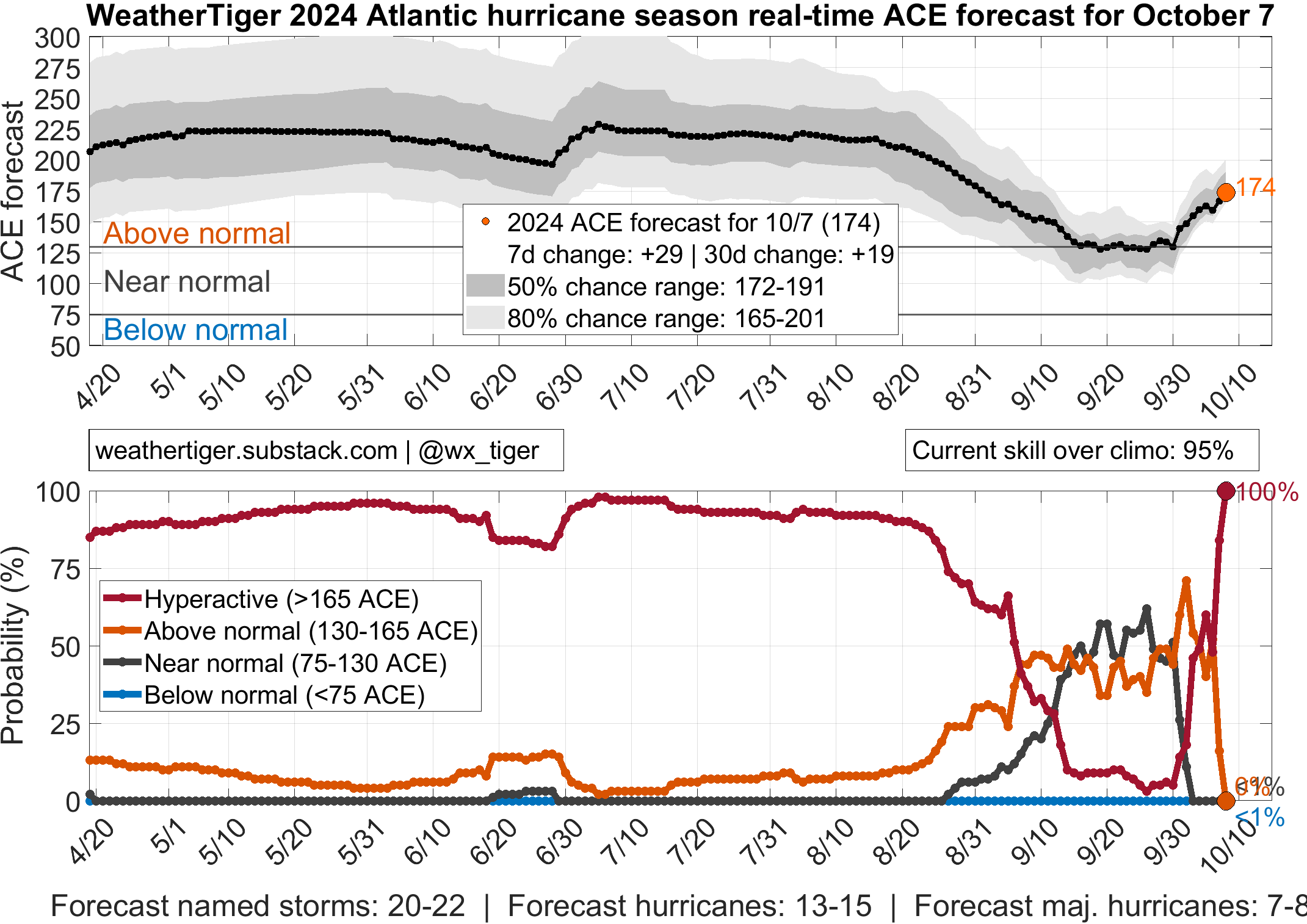
@SaviorofPlant Of the two predictions I ran I get (139 (exp., with RMSE of 15 to 20), and 152). Weathertiger is slightly above. Given it's supposed to be relatively normal (quiet) for the next month this seems less likely... This is in part the reason I created the Nadine market:

Uhh I have no clue how he gets 100% but this seems wrong... we should be in the neighborhood of ~ 138 ACE in ~ 3 days (when they are forecast to become post/tropical) if the forecasts for Leslie and Milton hold. (Milton adding a whopping ~25 ACE).
Unfortunately for me the higher the ACE the less robust my model gets as it is based on climatology (+ forecast ACE for current storms) and the samples that are useful are starting to dwindle...
