
Beginning June 12, 2024, the NHC tracked an area of low pressure (archived) in the southwestern Gulf of Mexico. If this particular disturbance strengthens and forms a named system (such as Tropical Storm Alberto), the market resolves YES. Resolves NO if the disturbance dissipates before that point.
 1,000
1,000🏅 Top traders
| # | Trader | Total profit |
|---|---|---|
| 1 | Ṁ3,889 | |
| 2 | Ṁ720 | |
| 3 | Ṁ162 | |
| 4 | Ṁ133 | |
| 5 | Ṁ111 |
People are also trading
This site shows 2-day and 7-day outlooks; switch between them using the “View …” button under the map.
A new outlook is issued every 6 hours: 2 am, 8 am, 2 pm, and 8 pm, Eastern time (UTC-4). All recent outlooks are archived and you can view them using the “Archived Outlooks” button above the map.
How does this market resolve if it's later determined that the official WMO protocol for naming tropical storms was violated?
Tropical cyclones will be given a name in the first advisory after intensifying to 34 knots or greater.
The advisory in which the NHC added the name showed no increase in intensity compared to the prior advisory. Additionally, their discussion carefully avoids mentioning observed wind speeds, and their public Dvorak method doesn't exceed 33 kt wind speeds:
https://www.nhc.noaa.gov/archive/2024/al01/al012024.discus.008.shtml
https://www.ssd.noaa.gov/PS/TROP/DATA/2024/adt/text/01L-list.txt
Aircraft and surface observations suggest the maximum winds remain about 35 kt, but the central pressure has dropped to about 995 mb according to the dropsonde data.
There's absolutely no reason to phrase it like that unless the dropsonde data recorded wind speeds under 34 kt. Otherwise you'd just attribute everything to the dropsonde. It's not possible to get surface wind speeds from an aircraft last I checked, so does anyone have any idea why they are giving vague values like "about 35 kt" from unspecified surface observations instead of exact values from a verifiable source?
Meanwhile, the NOAA site doesn't think there is an active storm:
Early or late classifications happen all the time and are often corrected post-season. If you're resolving according to NHC advisories, I would expect this not to matter
"It's not possible to get surface wind speeds from an aircraft last I checked, so does anyone have any idea why they are giving vague values like "about 35 kt" from unspecified surface observations" - This storm has a massive windfield, so it's plausible a boat or a buoy picked this up
I would also expect it not to matter, but it's isn't clear that this does resolve according to NHC advisories. "If this particular disturbance strengthens and forms a named system" could refer to being named by the NHC, or could refer to the storm being verified as strong enough to constitute a named system according to the WMO protocol. I expected the latter interpretation, since otherwise "strengthens and" could have been left out entirely, but I suppose the description also could have been specifying two distinct requirements rather than clarifying what was meant by "forms a named system". Although it would have been bizarre for the NHC to name the disturbance without it strengthening I suppose it would have been possible. Alternatively the description was just being redundant. That's why I'm asking for clarification.
It's plausible a buoy measured surface wind speeds and that's what they're relying on, but then I'd expect them to phrase it as "surface observations confirm maximum sustained winds..."
Why use language like "suggest" and slip up by saying "maximum winds" which could mean wind gusts instead of "maximum sustained winds"?
This is especially odd since the report goes on to confuse matters further with:
Some of the dropsonde and oil rig data in the northwestern Gulf indicate that stronger winds are located not too far above the ocean surface, but the environment appears too stable for sustained winds of that magnitude to mix efficiently down to the surface.
Why would they even mention this? Unless this is also their surface wind speed observations, but then why do they specify in the northwestern Gulf? This is a ridiculous amount of detail for this kind of report without giving any actual hard numbers. It sounds like exactly what I'd expect someone to write if they were rationalizing the classification of the cyclone as a tropical storm. Which, if this market is intended to resolve YES in such circumstances then that's fine, but I'd still like clarification.
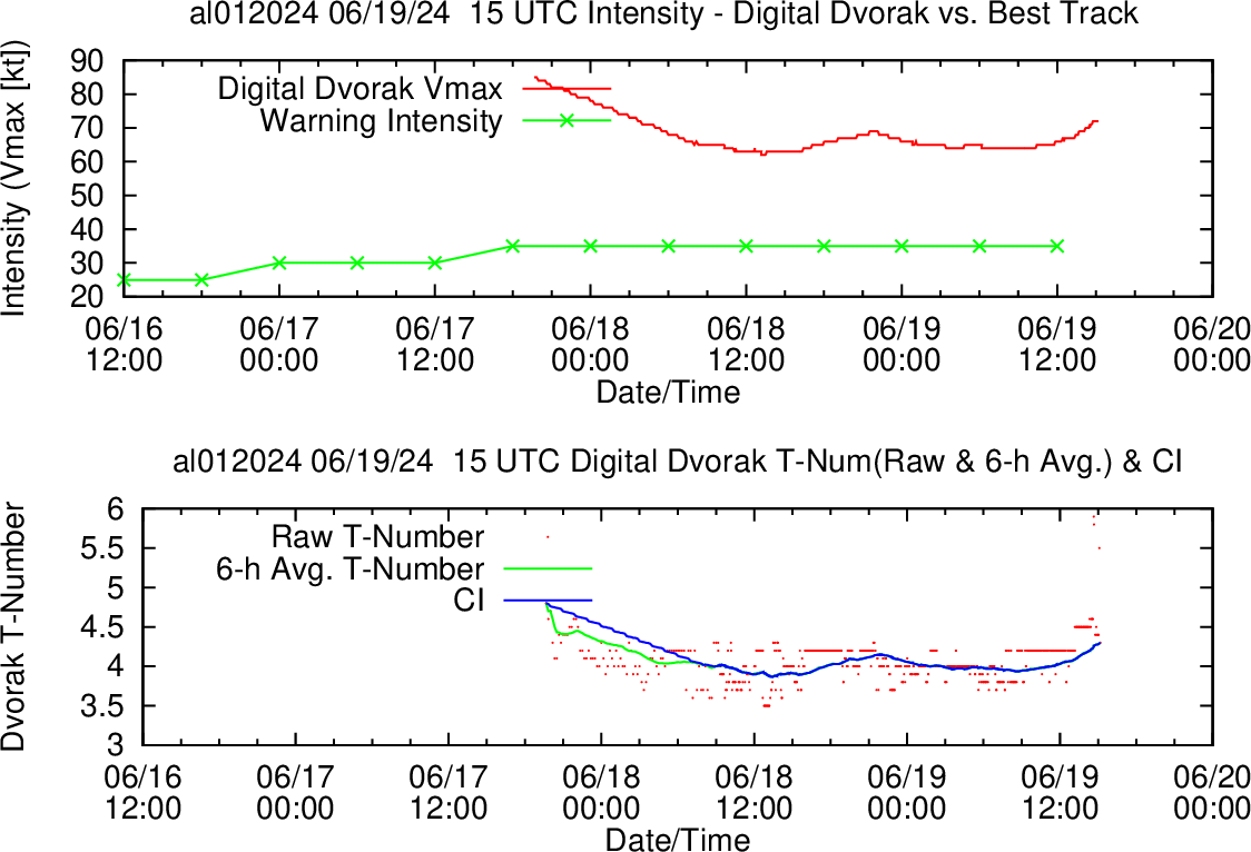
"It's not possible to get surface wind speeds from an aircraft last I checked" - it's estimated using SFMR. Recon aircraft readings about an hour after the advisory reported 38 kt SFMR, so even if they jumped the gun a little, there's likely support now for TS winds.
https://www.tropicaltidbits.com/recon/recon_AF308-0401A-SURVEY_timeseries.png
I believe SFMR is often used for classification (particularly upgrading depressions to storms), although not exclusively
AFIK NHC officially relies mainly on TAFB, not OSPO/SSD, for subjective Dvorak analysis (but I’ve seen them cite many different types of sources).
TAFB recorded 2.0/2.0 earlier this afternoon, and their latest fix has it as a TS (2.5/2.5) even if it is after the fact that it was named https://ftp.nhc.noaa.gov/atcf/fix/fal012024.dat
It is interesting since around when it became clear in visible satellite imager 12-13Z TAFB reported an analysis at 12Z (without FT/CI values) and then 13Z they did another where they gave it 2.0/2.0.
Only at 18Z did they raise it to 2.5/2.5.
Given that is what it is reported as a fix and the resolution criteria further more, I think it is moot regarding this market resolution.
Thanks for the source. That SFMR data looks far too unreliable for a classification to me: You can practically see the cyclical nature of the error bars in the graph. It looks like it's averaging maybe 34 kt for maybe half an hour. The dropsondes 10 minutes before and after the 15:29Z one were both 34 kt or less, as were all the others. I'd assume that one just got unlucky and got hit by a wind gust.
Yes, NHC might rely on TAFB when providing advisories, but the WMO protocol for naming very clearly relies on OSPO/SSD.
What's interesting is that the TAFB seems to still be uploading fixes: https://ftp.nhc.noaa.gov/atcf/fix/fal922024.dat
[EDIT: nvm, I'm an idiot. This is for the other disturbance in the same area, based on their file naming convention.]
I'm also not seeing 2.5 anywhere in that fix file you linked; am I just blind?
AL, 01, 202406191800, 10, DVTS, CI, , 2220N, 9510W, , 2, 35, 2, 1005, 2, DVRK, , , , , , , , , , , , , , L, TAFB, NR, V, 3, 2525 /////, , , GOES16, CSC, T, 2.5 is represented as 25. So above is:
V = Visible imagery referenced
2525 corresponds to FT=2.5, CI=2.5
CSC = cloud system center (center type and what was used for technique).
T = tropical
See doc under DVTS section: https://www.nrlmry.navy.mil/atcf_web/docs/database/new/newfdeck.txt
Thank you, I wasn't expecting it so late in the format, so late in the file, or to be formatted so strangely. They really should have those as multiple columns.
I was especially thrown off because it seems like they don't usually use DVTS to estimate storm intensity. Only the two most recent DVTS entries were used for that, so the rest don't have the corresponding data. Now I'm curious how they got 2.5 using the same data that SSD used to get 2.3 (2.4 now). Do they just round to the nearest .5?
I suppose the market was resolved, which indirectly answers my original question regardless.
ADT reports numbers like 2.4 and such.. only subjective Dvorak reports numbers in p.5 increments
Some educational material on subjective Dvorak: https://severeweather.wmo.int/TCFW/RAIV_Workshop2016/08_DvorakTechnique_JackBeven.pdf
OSPO does often post their own subjective Dvorak but for some reason they have not done so for Alberto:
https://www.ospo.noaa.gov/Products/ocean/tropical/bulletins.html
Ah, my bad for assuming they referred to the same method.
Do they really use a method with an error on the scale of 5-10 kt for classification? They've got more accurate direct measurements of wind speed than that!
Every other region under the WMO has to take into account conversion factors of 0.84-0.93 for wind speed averaging conversions. No way could they ever use something so loose.
Now I'm really hoping this cyclone picks up, or I might never trust the NHC directly again.
@thepurplebull Resolves YES: https://x.com/NHC_Atlantic/status/1803439610481221875
Bet on the intensity here! https://manifold.markets/SaviorofPlant/what-will-be-the-maximum-strength-o
Dvorak for Alberto should come online shortly: https://tropic.ssec.wisc.edu/real-time/adt/odt01L.html
ADT can specify what ever it wants for initial T values
I think only when it has a chance of imminent risk they’ll classify it as a TC without waiting for analysis ( to get around the subjective constraints ) as long as it has enough characteristics. It did plainly look like a TC around 12Z but even TAFB didn’t assign it even T1.0 at the time.
Might be a case where TC formation is imminent and they jumped the gun on classification to get people to take it more seriously, as you said
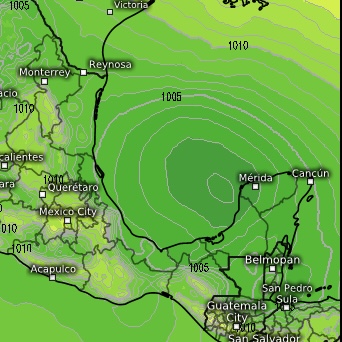
Latest guidance from 12Z has it moving faster west (putting landfall around 20/06Z) as the most recent fixes have made a roughly clearer circulation that is further west. NHC official forecast track (per discussion) has had it moving slower, yet the updated models gives it an earlier for landfall.
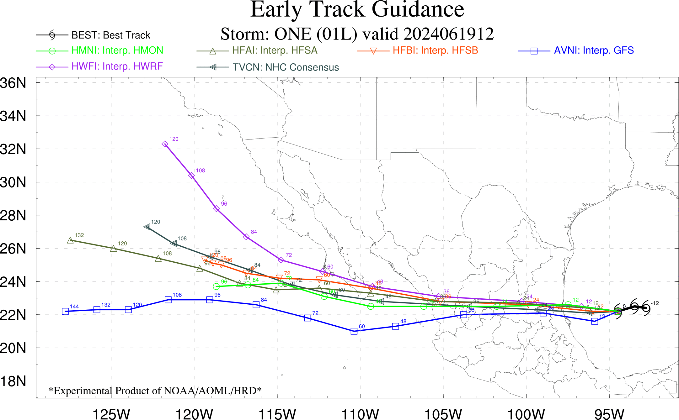
Most recent fix (12Z) from TAFB has it west of 95W:
AL, 01, 202406191200, 10, DVTS, C, , 2310N, 9530W, , 3, , , , , DVRK, , , , , , , , , , , , , , L, TAFB, NR, VI, 5, , , , GOES16, CSC, While OFCL has it slightly further east (as in the chart above):
AL, 01, 2024061912, , BEST, 0, 227N, 943W, 35, 997, DB, 34, NEQ, 360, 0, 0, 360, 1006, 360, 300, 0, 0, L, 0, , 0, 0, ONE, S, 0, , 0, 0, 0, 0, genesis-num, 003, Latest vis:
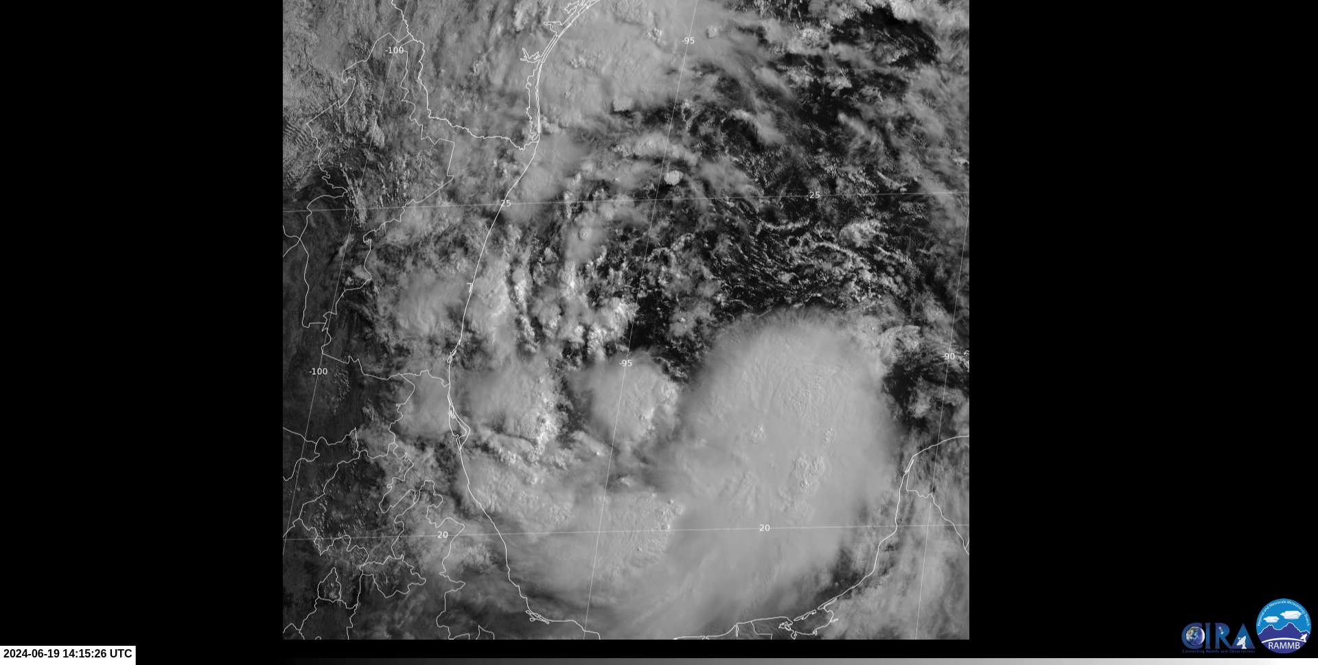
Plenty of convection in a primary band this morning, including some convection over what appears to be the low level center.
Haven't seen it organize in a positive direction today and the window for which to get it classified as a tropical storm seems to have decreased.
NHC discussion remains hedgy despite giving it 80% chance of development still:
The model trackers appear to be too fast relative to the model
fields themselves. As a result, the NHC official track forecast is
slower than deterministic and consensus trackers, and brings the
center of the system to the coast of Mexico in about 36 hours.
This could still be a little fast since the global models have the
center just offshore of Mexico at that time.
Global model fields suggest that the circulation will gradually
consolidate over the next 24 hours, and the center could be well
defined enough by then to designate the system as a tropical
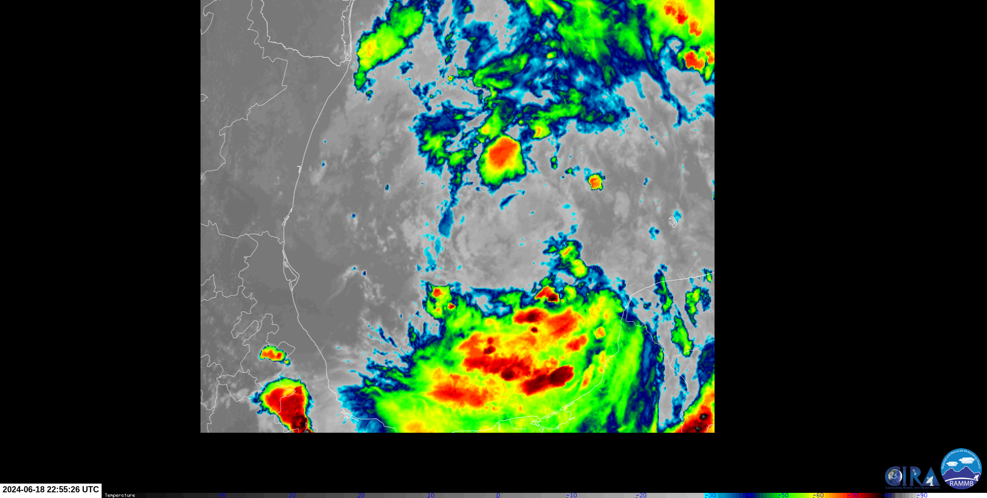
cyclone.Structure (CIRA analysis) looks worse to me in the afternoon than this morning:
Latest subjective dvorak (18Z) from TAFB still has it without a well-defined center of circulation:
AL, 01, 202406181800, 10, DVTS, C, , 2210N, 9330W, , 3, , , , , DVRK, , , , , , , , , , , , , , L, TAFB, ERA, VI, , , , , GOES16, CSC,
NHC discussion from seems to consider it might going to consolidate well enough in 36 hours with enough margin to classify as a TS, but the advisories over time have also shrunk the expected time that is expected to remain as a TS:
https://www.nhc.noaa.gov/archive/2024/al01/al012024.fstadv.001.shtml had it from 19/00Z to 20/00Z as a TS (~24 hours as a TS), and from the most recent two advisories it looks like only 19/12Z to 20/00Z (~12 hours as a TS).
There is more updated information but the chances of it getting classified seem to have shrunk to me. I understand the forecasters are flexible on how long the analysis period is needed for it to classify as a TS but it seems to me the chances are shrinking.
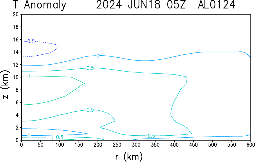
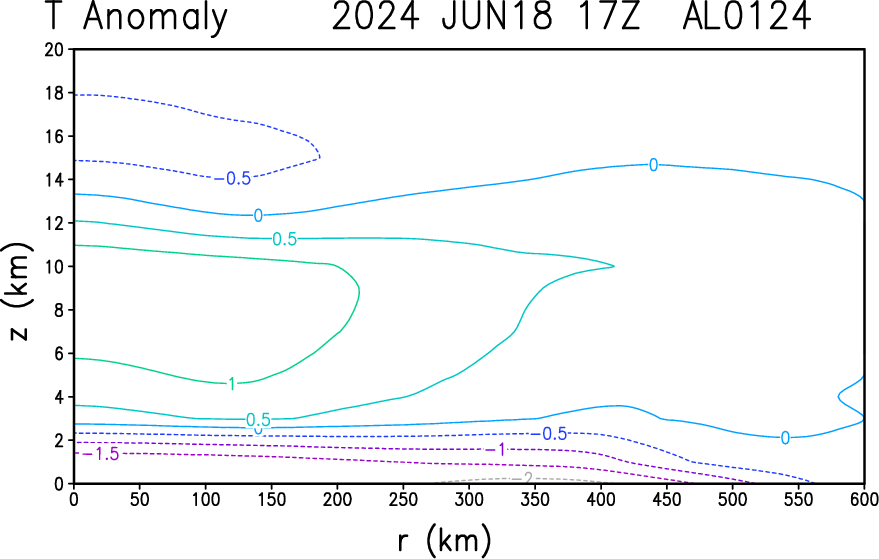
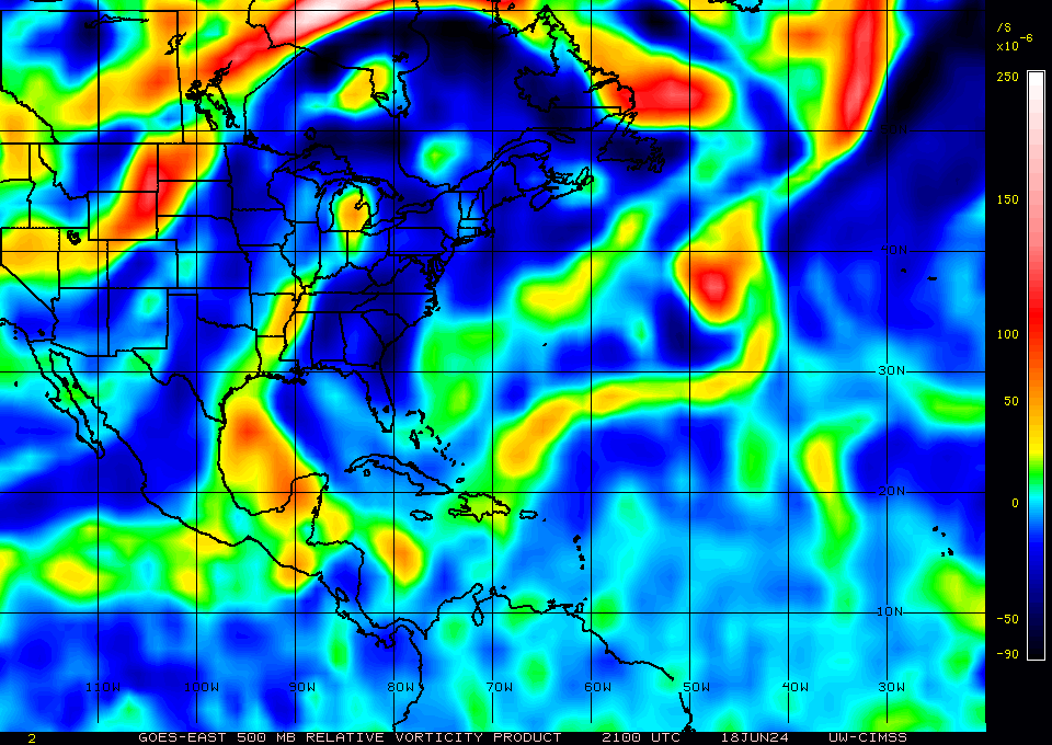
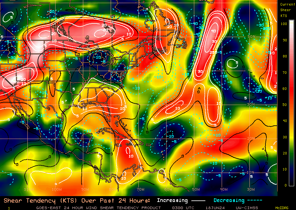
500mb Vorticity analysis (CIMSS) from 21Z shows it is still a very large circulation:
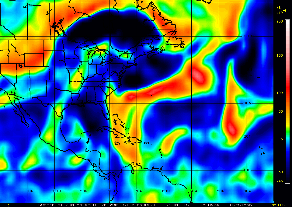
And 200mb Vorticity still shows barely positive spin:
Microwave Imagery (NRL) appears to show it is still disorganized:
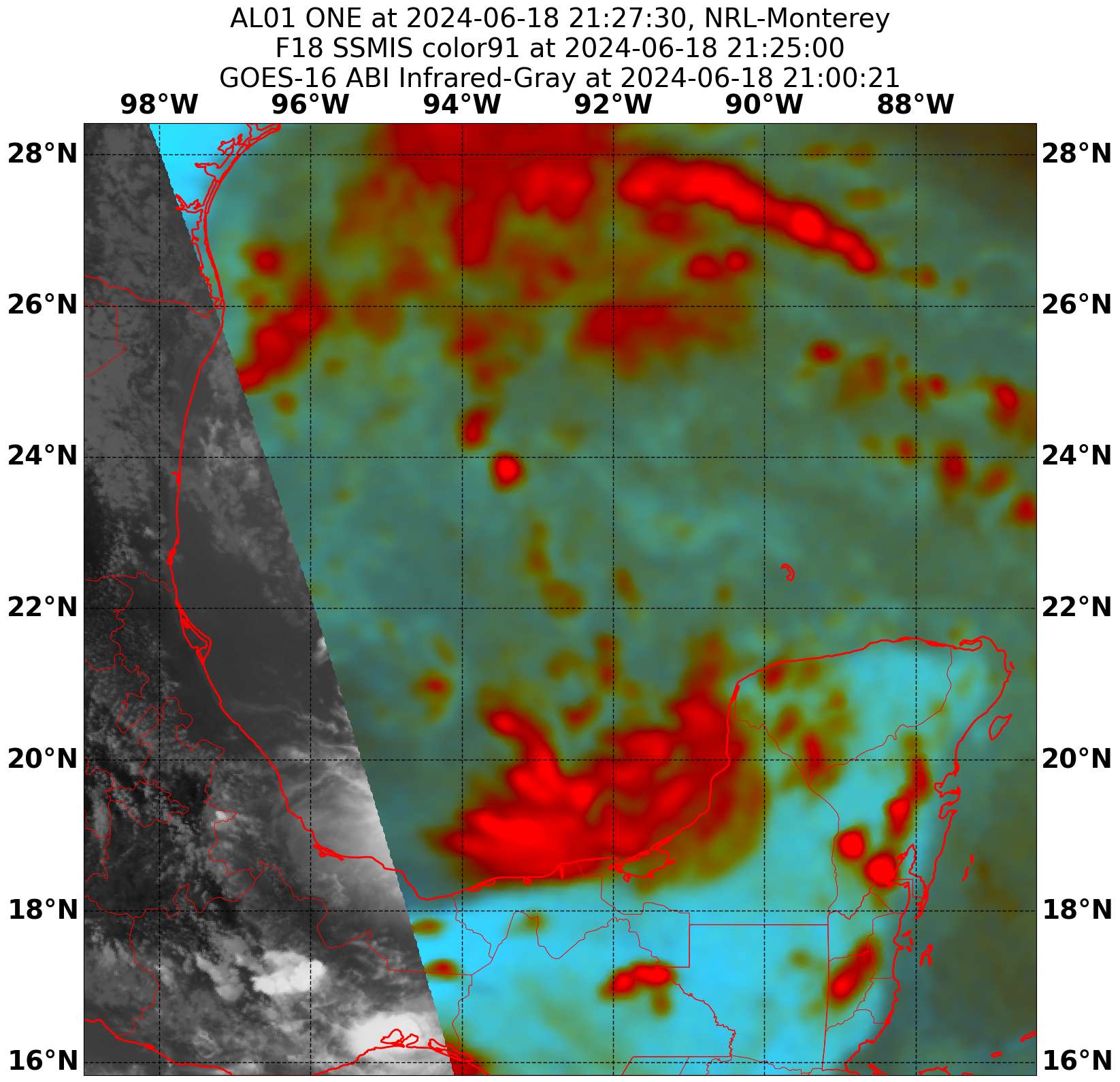
As does recent satellite imagery (CIRA/GOES-16) from the afternoon

@traders I acknowledge that there’s been some ambiguity in how this market should play out, given the disturbance this market refers to was originally unnamed.
In the spirit of this market, I believe it is reasonable to track the movement of the center of low pressure currently strengthening in the Bay of Campeche as was forecast last week. NOAA now terms the low Potential Tropical Cyclone One (PTC1).
NOAA is forecasting another low to form around the same area later this week. This was too far in the future to be forecast when this market was made, and won’t be continuous with PTC1 (which is now moving toward Tamaulipas). For these reasons, only PTC1’s development will be relevant for this market.
A couple clarifications as this develops:
PTC1 is not to be considered a named system in itself, only a possible precursor to a named system.
A “tropical depression” is not to be considered a named system. This market will only resolve YES if PTC1 strengthens into a tropical storm or hurricane, whereupon a name is assigned using the NHC list.