Will Vanuatu record winds (METAR) from TC Lola of at least 90 kt in October 2023?
This question will reference observations reported through METAR only.
Any other observations will not be considered to contribute to the resolution of the question.
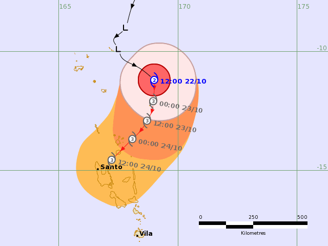
TC Lola is forecast to impact Vanuatu soon (before the end of October), per Fiji's Meteorological Service http://www.met.gov.fj/index.php?page=threadmap:
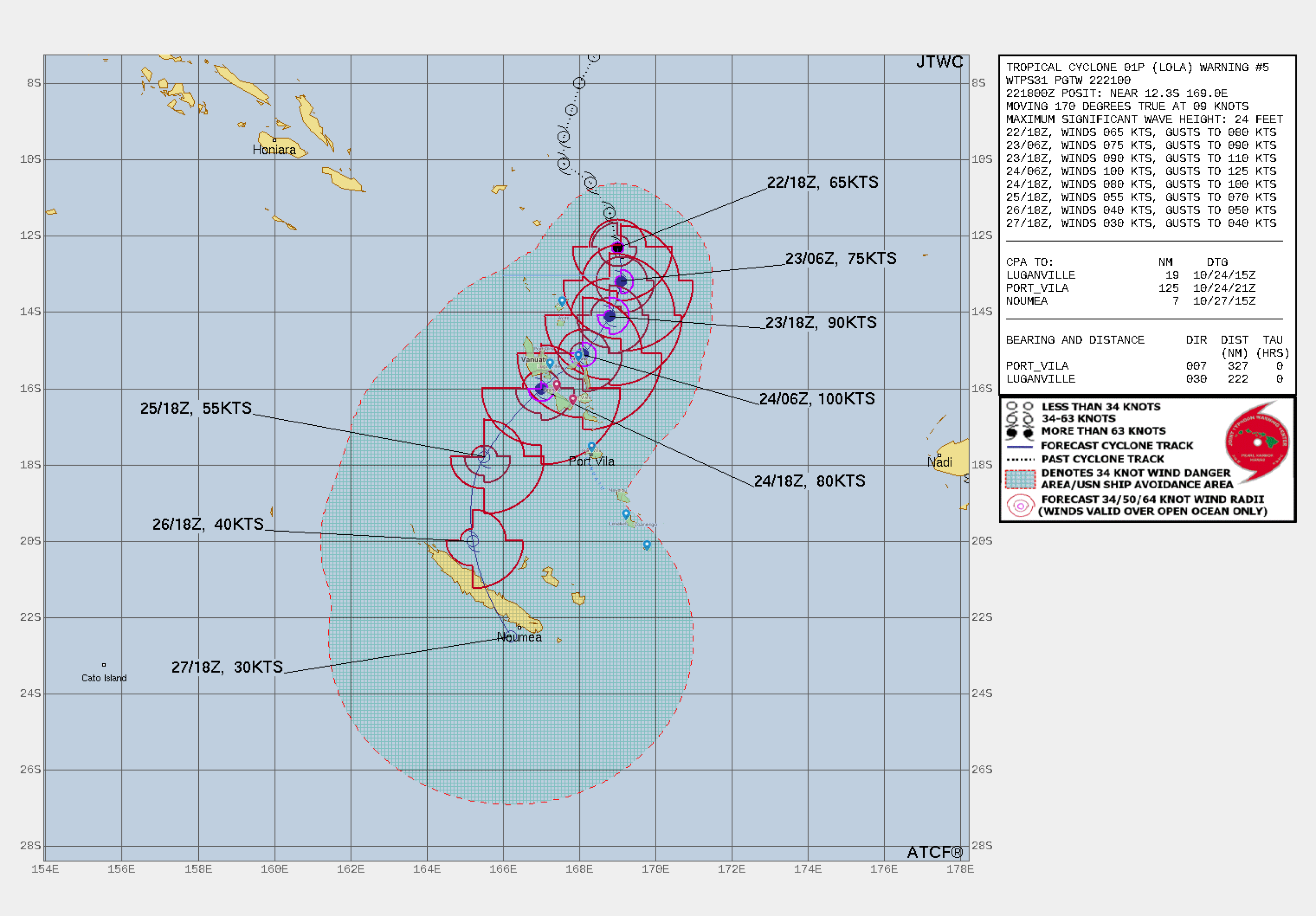
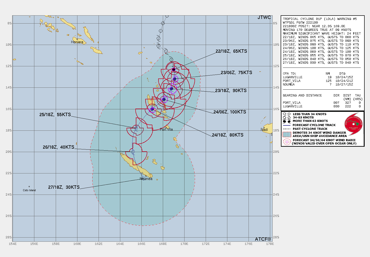
JTWC's warning advisory shows higher winds:
You can see general information about the METAR here:
http://www.vmgd.gov.vu/vmgd/index.php/forecast-division/aviation-forecast/metar
Resolution criteria, methodology, timing:
This question will reference observations reported through METAR only.
Any other observations will not be considered to contribute to the resolution of the question.
I must be able to observe (from the METAR list below) a wind speed of 90 kt or higher from any one of these METAR stations after October 22, 2023 00Z and before November 1, 2023, 00Z for this to resolve YES.
METAR list: NVSC NVSG NVSL NVSP NVSS NVVA NVVV NVVW
Note:
This question will resolve ahead of resolution time only if Lola dissipates per the Fiji Meteorological Service (RSMC Nadi).
I'll be using metar-go (https://github.com/esperlu/metar) which pulls data from aviationweather.gov:
go run metar.go -n 70 -m NVSC NVSG NVSL NVSP NVSS NVVA NVVV NVVW
and check for wind speeds at or above 90 kt.
I'll try checking this a few times a day up until resolution time.
Notes on metar-go and METAR stations in Vanuatu:
From metar-go, these are names of the METAR stations belonging to Vanuatu (the first four characters),
metar-go -la VU:
Vanuatu (OC)
NVSC SLH VU Sola Airport (Sola)
NVSG LOD VU Longana Airport (Longana)
NVSL LPM VU Lamap Airport (Lamap)
NVSP NUS VU Norsup Airport (Norsup)
NVSS SON VU Santo Pekoa International Airport (Luganville)
NVVA AUY VU Aneityum Airport (Anatom Island)
NVVV VLI VU Bauerfield International Airport (Port Vila)
NVVW TAH VU Tanna Airport
As far as I can tell NVSL and NVSP (Lamap and Norsup) have not been operational for some time (referencing the METAR database from ogimet.com), but I will include them since it is in the list.
I'll be referencing metar-go since it uses aviation-weather.gov which has the METAR history, but you can also see the latest ones here http://www.vmgd.gov.vu/vmgd/index.php/forecast-division/aviation-forecast/metar
 1,000
1,000🏅 Top traders
| # | Trader | Total profit |
|---|---|---|
| 1 | Ṁ76 | |
| 2 | Ṁ21 |
People are also trading
This resolves NO:
METAR with the highest wind speed (not gust):
NVSG 240800Z 16030G40KT 9999 -SHRA BKN018 OVC100 26/25 Q0999 [26 26 94%]
Highest wind speed: 30 KT
That was also Longana Airport's last METAR report. I waited until resolution time to see if that or another automated system would end up filling a backlog (perhaps due to communications outages) but apparently that was not case.
I don't think I will be repeating these types of observatory based markets in the future with respect to extreme weather as there are too many reasons for them to resolve NO (including the possibility of communications outages or the operator removing the equipment to protect it).
@parhizj yeah i pretty much knew this was not going to resolve yes from the get go, even if lola did bring 90 kt winds to vanuatu... i'm not sure i've ever seen a metar report a 90 knot sustained wind anywhere ever
Ohhhh my... I don't think I have ever seen an October Cat V in the South Pacific. That is waaaay early. Super-charged ENSO things?
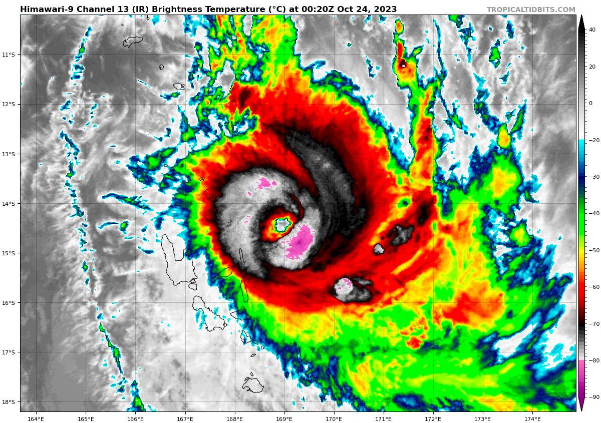
Yeah, seeing this kind of storm in October is wild. If you showed the IR Sat and told me "Oh this is an early Cat V in the South Pacific. Can you tell me the month?" I'd probably say something like late December/early January.
I wonder how 23/24 will compare to 02/03, given that it's off to this kind of start.
https://www.vmgd.gov.vu/vmgd/index.php/forecast-division/tropical-cyclone/warning
The central pressure of the system is estimated at 914 hPa.  Winds close to the centre
are estimated at 215 KM/HR (115 knots), gusting up to 189KM/HR (102KTS)within 16 Nautical miles
from the center of the system and expected to affect the Islands of TORBA, SANMA, PENAMA &
MALAMPA in the next 24 hours. Severe Tropical Cyclone LOLA (CAT 5) is forecasted to be at
 14.9 degrees South 168.7 degrees East within the next 06 to 12 hours.

Destructive hurricane force winds of 165KM/HR (90KTS)are expected to affect
TORBA, SANMA, PENAMA & MALAMPA in the next 24hrs.I overlaid the airport locations onto the JTWC forecast map for a direct reference of the locations (drop pins). Red drop pins are Lamap and Norsup that are not operational.
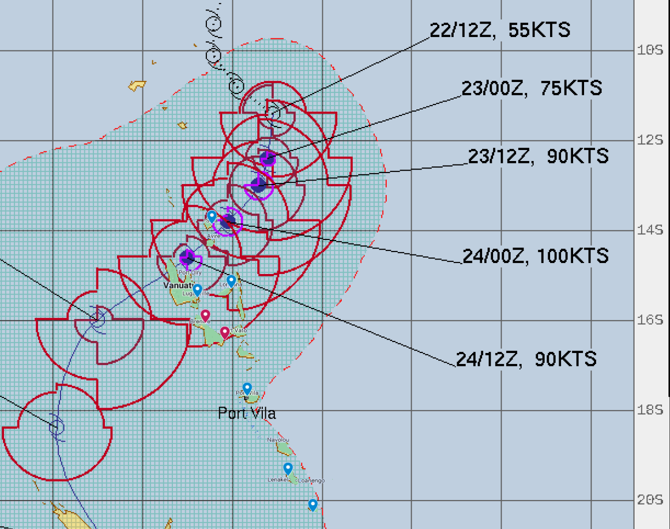
Sola appears to be the closest to the forecast path where Lola will be at its peak strength according to JTWC, followed by Santo-Pekoa and Longana.
@parhizj Cheers. I input the locations of the airports into My Google Maps, took a screenshot and then overlaid it on the map with Clip Studio after removing the colour of the sea.
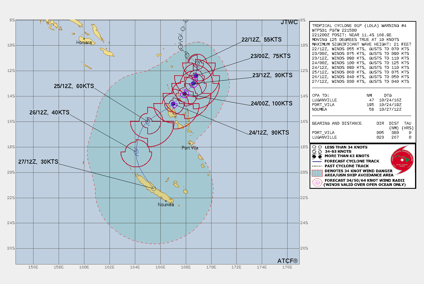
@parhizj Updated map. Applied some transparency for clarity. This time Longana seems to be closest, well within the 64 kt wind radius and almost right on the path.