
 1,000
1,000🏅 Top traders
| # | Trader | Total profit |
|---|---|---|
| 1 | Ṁ1,837 | |
| 2 | Ṁ643 | |
| 3 | Ṁ317 | |
| 4 | Ṁ123 | |
| 5 | Ṁ114 |
https://manifold.markets/SaviorofPlant/what-will-be-the-minimum-central-pr?play=true
Follow up market that doesn't close early
For bettors, not much time left to close.
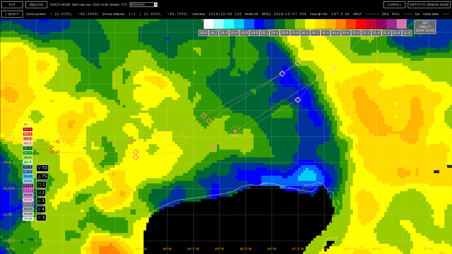
Below, zoom of the SST temps (note it is Night and Day combined from (scale is narrow to show fine differences): https://coastwatch.noaa.gov/pub/socd2/coastwatch/sst_blended/sst5km/daynight/ghrsst_ospo/2024/)
With the regional model tracks
Per https://www.nhc.noaa.gov/text/MIAREPRPD.shtml, there should be 3 planes doing recon at the model time where HAFS-A is showing a cat 5:
Not mentioned in the NHC discussion is the drop in the extreme RI probabilities from SHIPS (DTOPS doesn't even report values) as I suppose the intensification has been steady and even (~40 kt for Oct 6 previously, and now again forecast for Oct. 7).
5 PM relevant discussion:
The intensity forecast appears straightforward at first, with rapid
intensification likely while the small hurricane remains within
light shear and over very deep warm waters.  Intensity guidance is
about as bullish as I've seen in this part of the basin, with
almost everything showing a peak intensity of category 4 or 5 in
the southern Gulf of Mexico in a day or two.  The NHC forecast is
raised from the previous one and lies near the intensity consensus
model and still could be too low.  Later on, vertical wind shear is
forecast to markedly increase as Milton approaches Florida, and
some weakening is anticipated.  However, the regional hurricane
models are showing the system growing even if it weakens, and we are
expecting Milton to be a large hurricane at landfall, with very
dangerous impacts spread out over a big area. There is increasing
confidence that a powerful hurricane with life- threatening hazards
will be affecting portions of the Florida west coast around the
middle of this week. Residents there should closely monitor this
system and listen to local officials.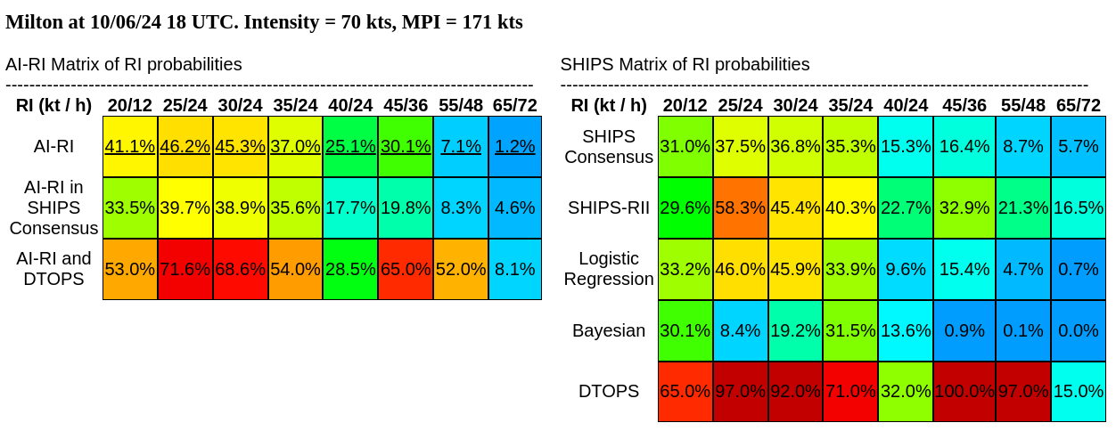
@ScottSupak You called it.
---
Milton erupts into Category 1 hurricane as Southeast reels from Helene aftermath
https://ground.news/article/ron-desantis-urges-floridians-to-prepare-for-a-major-hurricane-again-and-hold-steady_07403f?utm_source=mobile-app&utm_medium=newsroom-share

NHC now forecasting a major hurricane:
FORECAST POSITIONS AND MAX WINDS
INIT 05/2100Z 22.7N 95.5W 35 KT 40 MPH
12H 06/0600Z 22.9N 95.0W 45 KT 50 MPH
24H 06/1800Z 23.0N 94.1W 55 KT 65 MPH
36H 07/0600Z 23.0N 92.8W 70 KT 80 MPH
48H 07/1800Z 23.1N 91.2W 80 KT 90 MPH
60H 08/0600Z 23.8N 89.3W 90 KT 105 MPH
72H 08/1800Z 24.8N 87.2W 100 KT 115 MPH