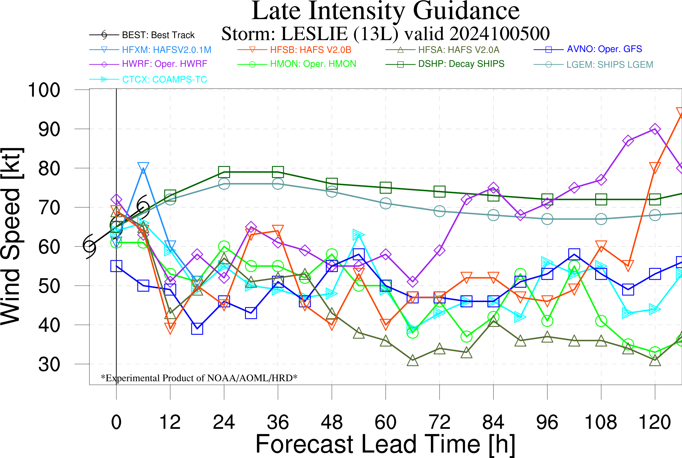
Resolves according to operational intensity, ignoring post-season adjustments.
Since this is a Basic market, you'll need to place limit orders and have someone fill them to make a significant profit on this market.
🏅 Top traders
| # | Trader | Total profit |
|---|---|---|
| 1 | Ṁ257 | |
| 2 | Ṁ21 | |
| 3 | Ṁ11 | |
| 4 | Ṁ9 |
People are also trading
@SaviorofPlant Leslie is done.
https://www.nhc.noaa.gov/text/refresh/MIATCDAT3+shtml/121442.shtml
Remnants Of Leslie Discussion Number  41
NWS National Hurricane Center Miami FL       AL132024
300 PM GMT Sat Oct 12 2024

ASCAT-B data valid near 1300 UTC indicated that Leslie's fast
forward motion has caused it to open into a trough. Therefore, this
will be the last NHC advisory on Leslie. The ASCAT data indicated
that winds of 40-45 kt are still present on the east side of
Leslie's remnants, where it continues to produce limited deep
convection.

A mid-latitude frontal system is nearing the remnants of Leslie, and
the two systems are expected to merge within the next 12 h or so,
marking Leslie's full transition to a post-tropical cyclone. It is
possible that Leslie will redevelop a closed circulation as a
non-tropical low at that point. The cyclone is expected to turn
eastward on Sunday, bringing it very near or over the Azores late
Sunday and through early Monday. By Monday afternoon, Leslie's
center is expected to become poorly defined again as it interacts
with another weaker mid-latitude cyclone to the east of the Azores.
Hurricane Leslie Discussion Number  32
NWS National Hurricane Center Miami FL       AL132024
500 AM AST Thu Oct 10 2024

The satellite presentation of Leslie has degraded since the previous
advisory.  Based on geostationary satellite imagery, the eye feature
has filled, deep convection have shifted to the southern side of the
circulation, and the outflow appears to be impinged in the northwest
quadrant.  Subjective and objective Dvorak intensity estimates have
plateaued, with final-T numbers coming down.  The initial intensity
is held at a possibly generous 90 kt, in agreement with the latest
TAFB and SAB estimates.

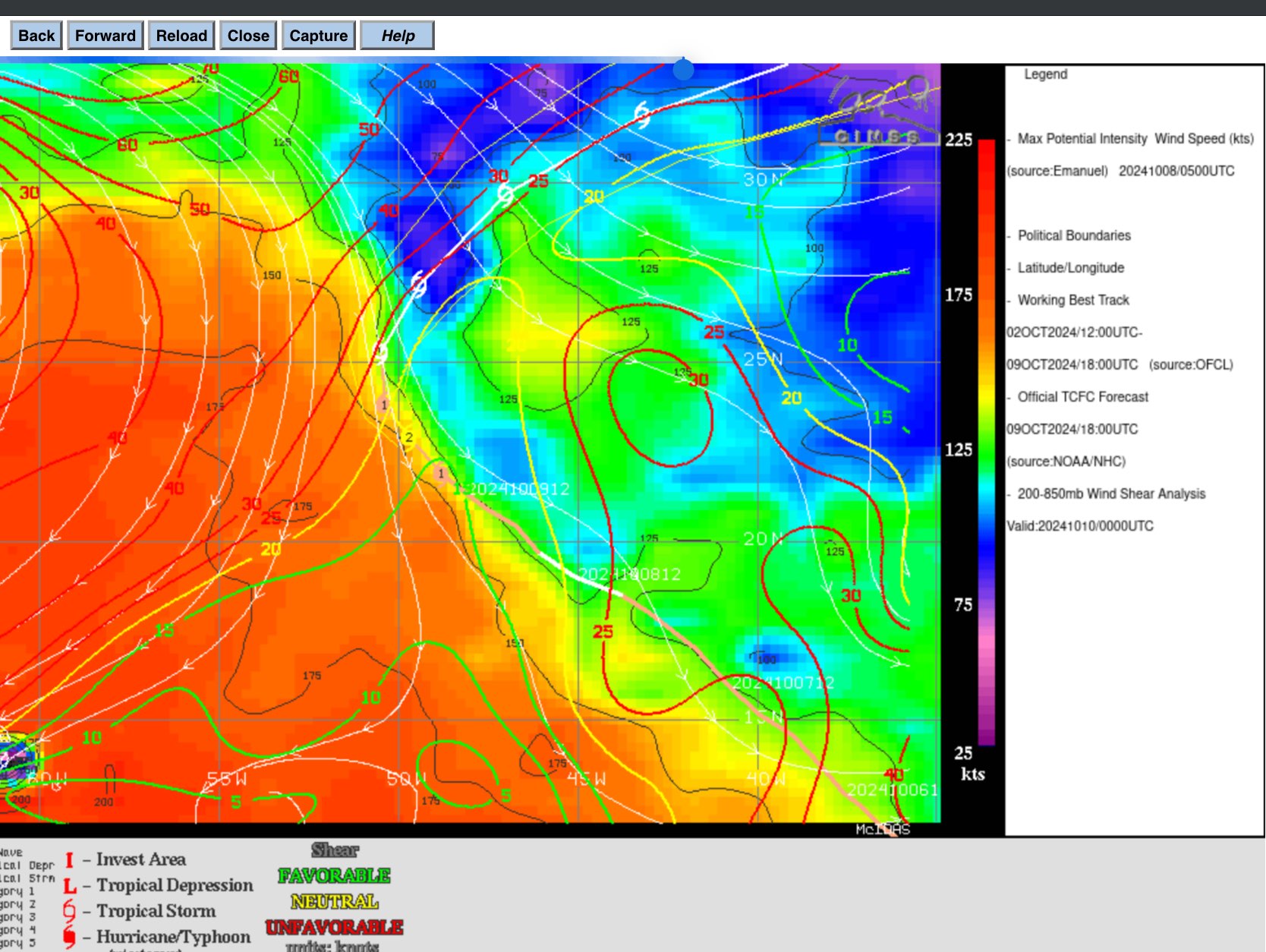
The window for intensification seems to have closed.  Vertical wind
shear appears to be strengthening significantly over Leslie.  Global
models insist the strong upper-level winds will strip away deep
convection and force in the surrounding dry mid-level humidities
into the circulation quickly.  Given the relatively small size of
the hurricane, rapid weakening is expected over the next few days.
Leslie is now forecast to become a post-tropical cyclone by Sunday
and open into a trough by early next week.

Leslie is moving northwestward at about 5 kt.  This motion should
continue through today as Leslie moves around the southwestern
periphery of a subtropical ridge over the eastern Atlantic.  On
Friday, the hurricane should speed up and turn to the north and
north-northeast, followed by a turn northeastward and
east-northeastward as it accelerates further over the weekend.
There have been only minor changes to the latest NHC track forecast,
which lies essentially on top of the previous prediction and between
the various consensus aids.
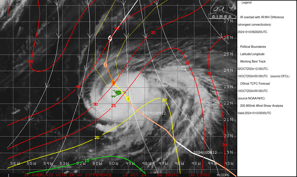
Shear came earlier than expected... Outflow from (Milton & 93L ? per last NHC discussion) are visible from imagery -- DVTS from both TAFB/OSPO have kept the CI but the Final-T are lower, so it looks like it will remain a category 2.
(I guess this is what the EPS from 12Z yesterday was hinting at was this -- regional models couldn't pick this up as their parent isn't big enough to cover Milton so far away)
Betting was too confident last 24 hours... (and maybe still.. but I don't see how it could possibly strengthen again with this shear...)
The late regional models now all have points reaching cat 4..
edit: tcvitals puts it at 90 kt sitll... I read off Milton's line by accident.. =(
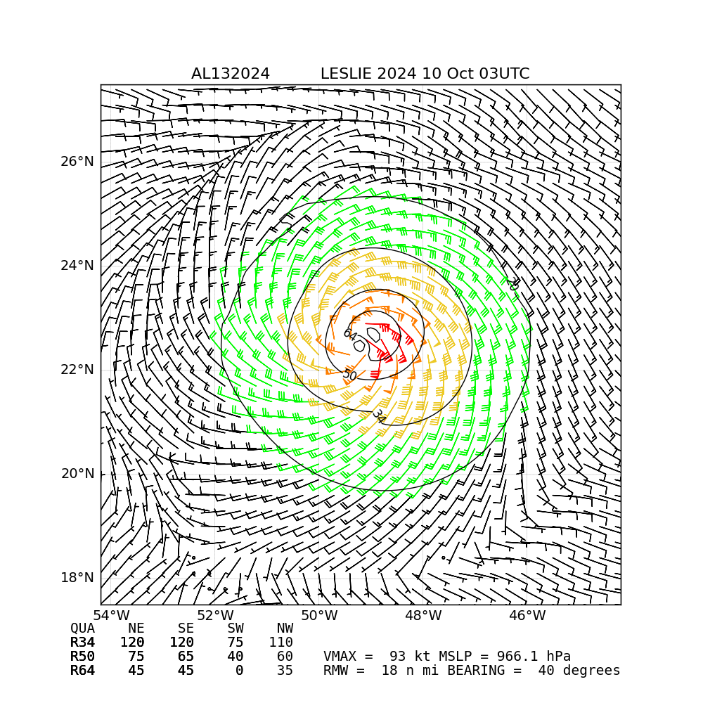
https://www.nhc.noaa.gov/text/refresh/MIATCMAT3+shtml/100241.shtml
NHC now forecasting 100 kt
relevant discussion
As noted previously, another saildrone (SD-1040) indicated that
sea-surface temperatures near Leslie are warmer than expected, near
29 C. At the same time, the hurricane is in a very narrow region of
low vertical wind shear that should persist for another 6-12 h.
While the interpolated intensity guidance is a bit lower, the raw
model output of all four of the hurricane-regional models (HAFS-A/B,
HMON, HWRF) show Leslie briefly becoming a major hurricane in 12 h.
Because the raw model output from these intensity aids has been
outperforming the interpolated guidance over the past day, the NHC
intensity forecast will now show a 100 kt peak tomorrow morning.
However, this peak is likely to be short-lived, as strong
upper-level northerly flow, via outflow from Milton and Invest 93L,
will soon overtake the hurricane, likely leading to rapid weakening. @parhizj I put 600 mana into Cat 3 a week ago, but I was not expecting the path there to look like this LOL
the partial regional 00Z models (hmon, hafsa, hafsb until next 12 hours) show it reaching cat 4 or peak cat3 … it’s less likely that this will coincide with the subjective Dvorak and further with an advisory though…
ships I think is based off a track that’s not reality… thus its low RI probabilities as I think it is actually slightly west again of forecast track.. (image below)
2024OCT10 035020 4.8 973.3 84.8 4.5 5.0 5.4 0.5T/hour ON OFF OFF OFF -20.36 -62.12 EYE -Raw Data t supports cat 3 now that an eye has cleared up on IR
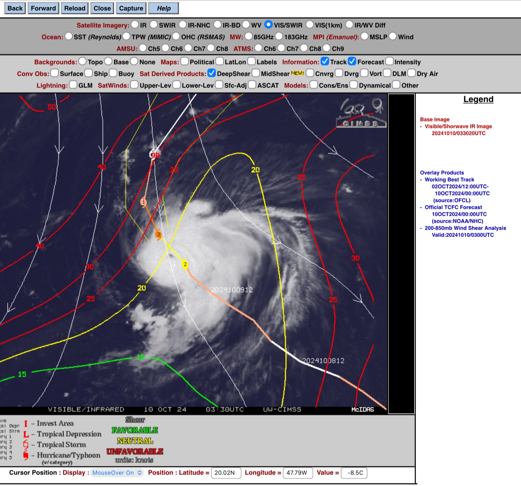
Waiting on only hwrf…
Already a cat 2 per best track
Based on the 18Z models that got the intensity right the last couple synoptic hours (despite some lower objective estimates) I’m increasing my bet in cat. 3 to more likely.. it’s a narrrow window, so only 5 am or 11 am advisory is possible.. likely will be kept near 90 kt for 11pm advisory (TAFB/OSPO were between 5.0, 5.5)
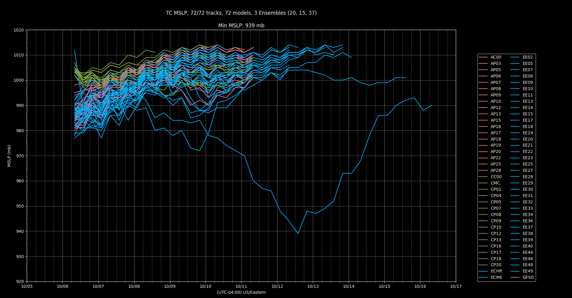
AL, 13, 2024101000, , BEST, 0, 223N, 490W, 90, 972, HU, 34, NEQ, 60, 60, 60, 60, 1014, 130, 10, 110, 0, L, 0, , 0, 0, LESLIE, D, 0, , 0, 0, 0, 0, genesis-num, 030, From NHC advisory error I'd be very confident it would not restrengthen. However that small signal of restrengthening from EPS is slightly higher now (depending on how you treat the EPS members). The EPS/00Z members are initialized on a much wider array of pressures that could be contributing. I don't really know what the estimated MSLP error range is but pruning loosely by +- 5 MSLP and position on NHC advisory for 09Z I still get a chunk of members showing some possibilities...
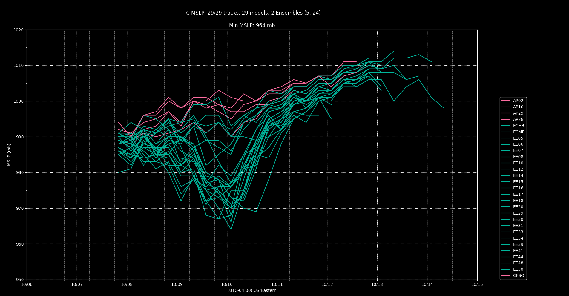
Pruned members (by position 0.75 degrees tolerance, and +- 5 MSLP):
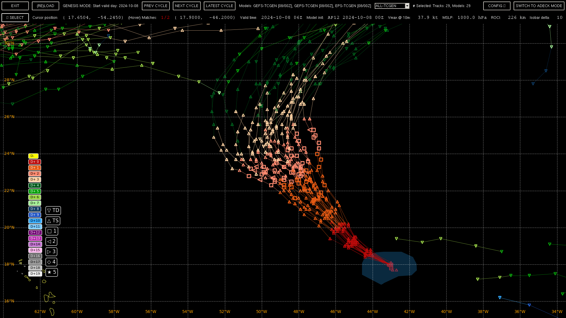
Unpruned: (much more western track variation appears)
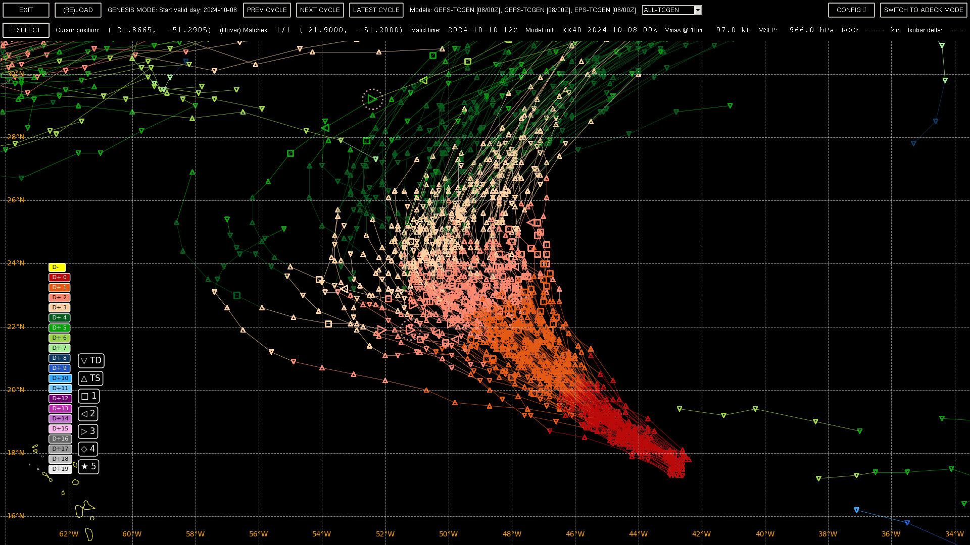
@SaviorofPlant Thanks! I neglected to see if they would change the forecast... It's now a Hurricane though again.
Leslie appears to have made a bit of a comeback today.  A couple of
fortuitous microwave images from the past few hours show a closed
eyewall.  The latest subjective Dvorak classifications from TAFB and
SAB range from 55-77 kt, and recent objective estimates range from
65-74 kt.  The microwave passes, the objective intensity estimates,
and the TAFB current intensity number all suggest that Leslie is a
hurricane.  Therefore, the initial intensity is bumped back up to
65 kt.
They put the pressure though at 992 hPa though for a hurricane (fairly high), in the 25-30% range suggesting that this might possibly be a conservative estimate for the pressure (POUTER is 1012 per TCVITALS)
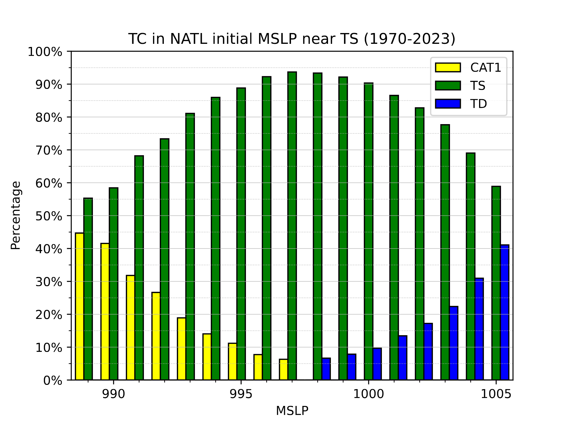
CIMSS AND OSPO ADT:
2024OCT08 211020 4.5 978.3 77.0 4.5 4.5 3.3 MW ON OFF OFF OFF OFF -74.56 -61.48 UNIFRM N/A 41.6 20.02 46.42 FCST GOES16 40.1 2024OCT08 211020 4.5 978.3 77.0 4.5 4.5 3.3 MW ON OFF OFF OFF OFF -74.56 -61.48 UNIFRM N/A 41.6 20.02 46.42 FCST GOES16 40.1 AiDT implies around 983 hPa from its wind speed
SATCON: MSLP = 989 hPa MSW = 75 knots
Given the range in intensities and pressures from ADT, I think it would be better to just use this range to constrain the ensemble members that fit 21Z... (978.3 to 994) however if the MSLP is close to one end or another it will end up being generous for the other side's probabiltiies..
So using 978.3 to 994 as a constraint for 21Z:
(973 being the ~50% for a cat 2, so we take half of the 22% to get about 11 %)
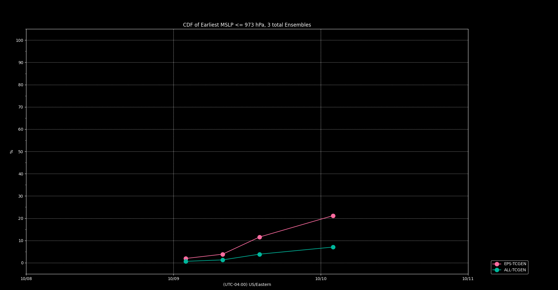
This is a weaker signal than yesterday's analysis from 12Z... To make sure its more robust we compare a mid range cat 2 at 968 hPa, which is a stronger storm to get 8%, so the 11% seems reasonable considering EPS alone. It is important to note that these probabitlies are normalized on the ensemble member count (not on the total leftover after pruning), so they are also under-estimates in this additional sense.
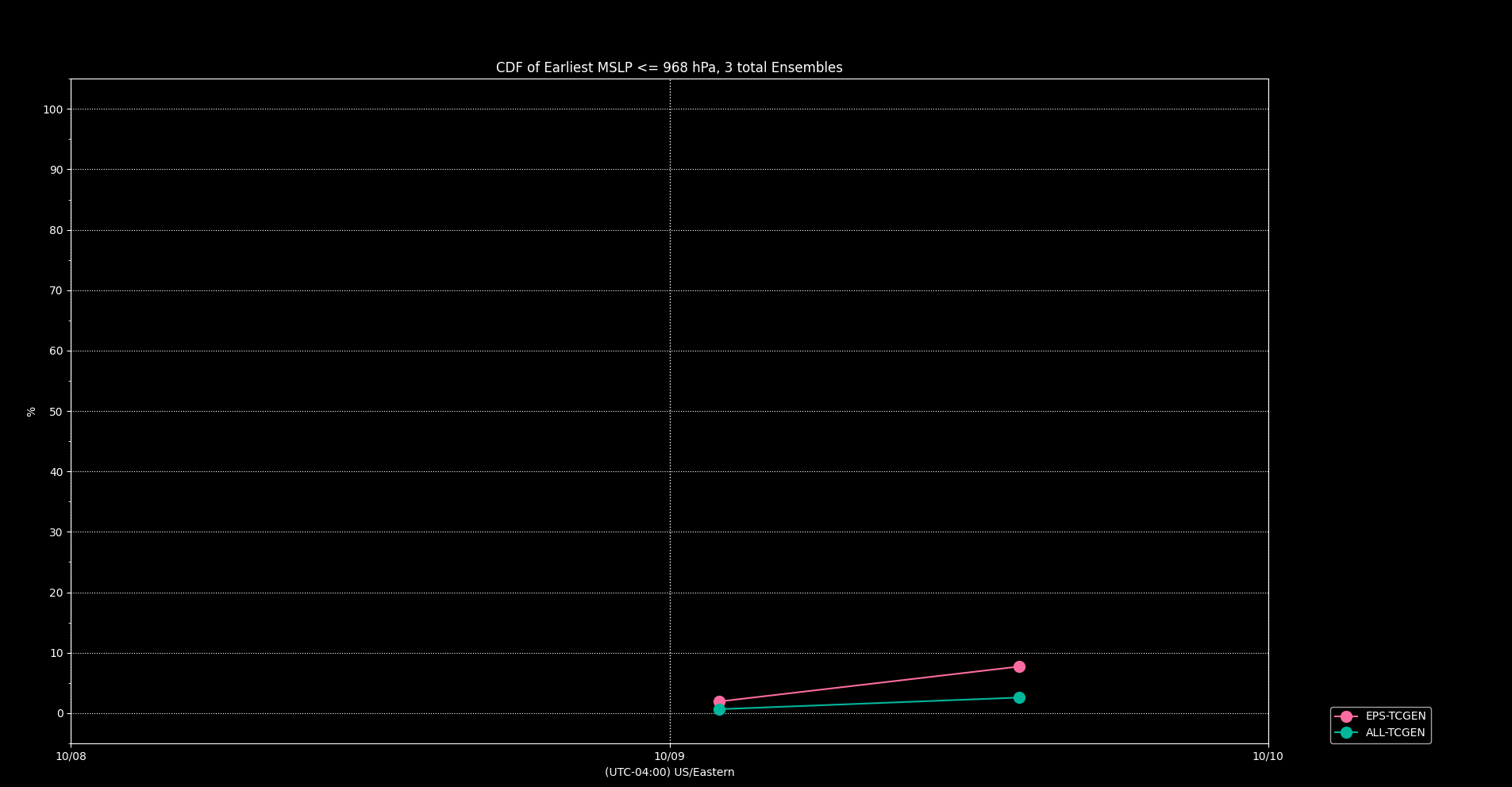
These global models tend to underestimate the pressure for hurricanes so it is not unreasonable to only consider EPS by itself (and entirely neglect the super-ensemble probabilities at all since they tend to be even greater underestimates); ie. : in the filter for 21Z none of the GEPS made it, and only 12/22 of the GEFS made it (including GFSO), showing its probabilties are likely undercounts by nearly half. Similarly, but less so for EPS at 41/52
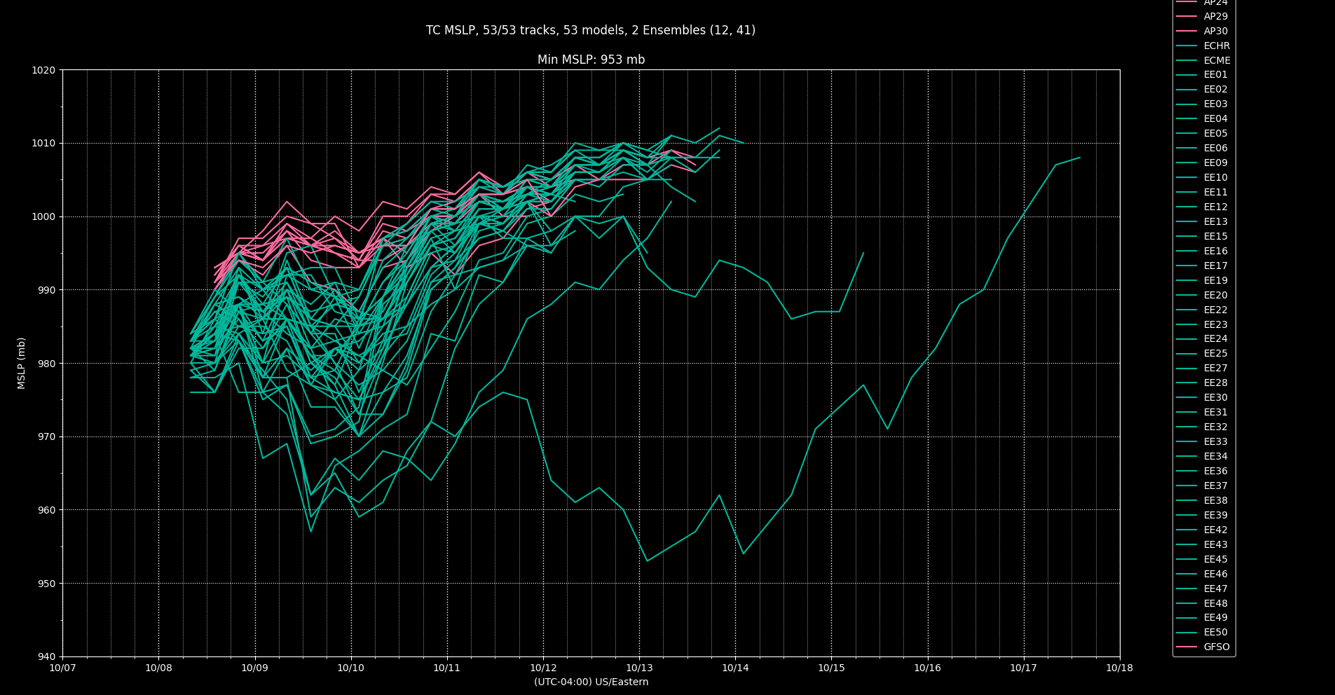
If we are speculative and "normalize" by these counts EPS (52/41) * 0.11 ~= 0.14. This is about as generous an objective probabilty as I can establish for EPS. Still less than yesterday, so I will sell some shares...
For reference the advisory error % I get from my notebook puts it at 10% (this is an overestimate as I use a much larger time range and forecasting error has decreased substantially).
I neglected to look at the regional models...
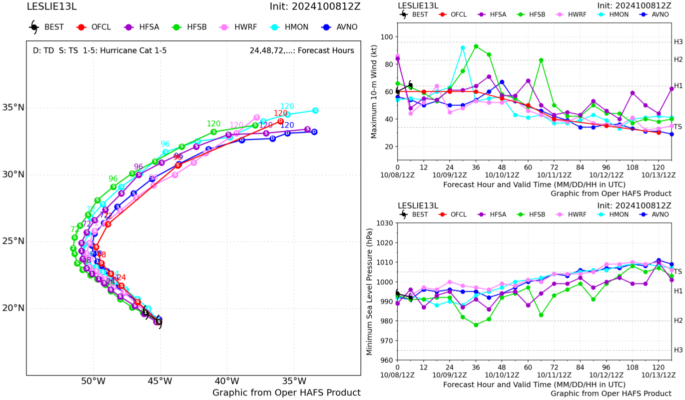
Both HAFS/12Z show it becomnig a CAT 2 and were initialized in a reasonable intensity range -- given this I'm going to go back and increase my bet again.... Notably they show a more western track. The pruned super ensemble shows similar possibilities but this is west of the mean track (thick solid line)
Edit:
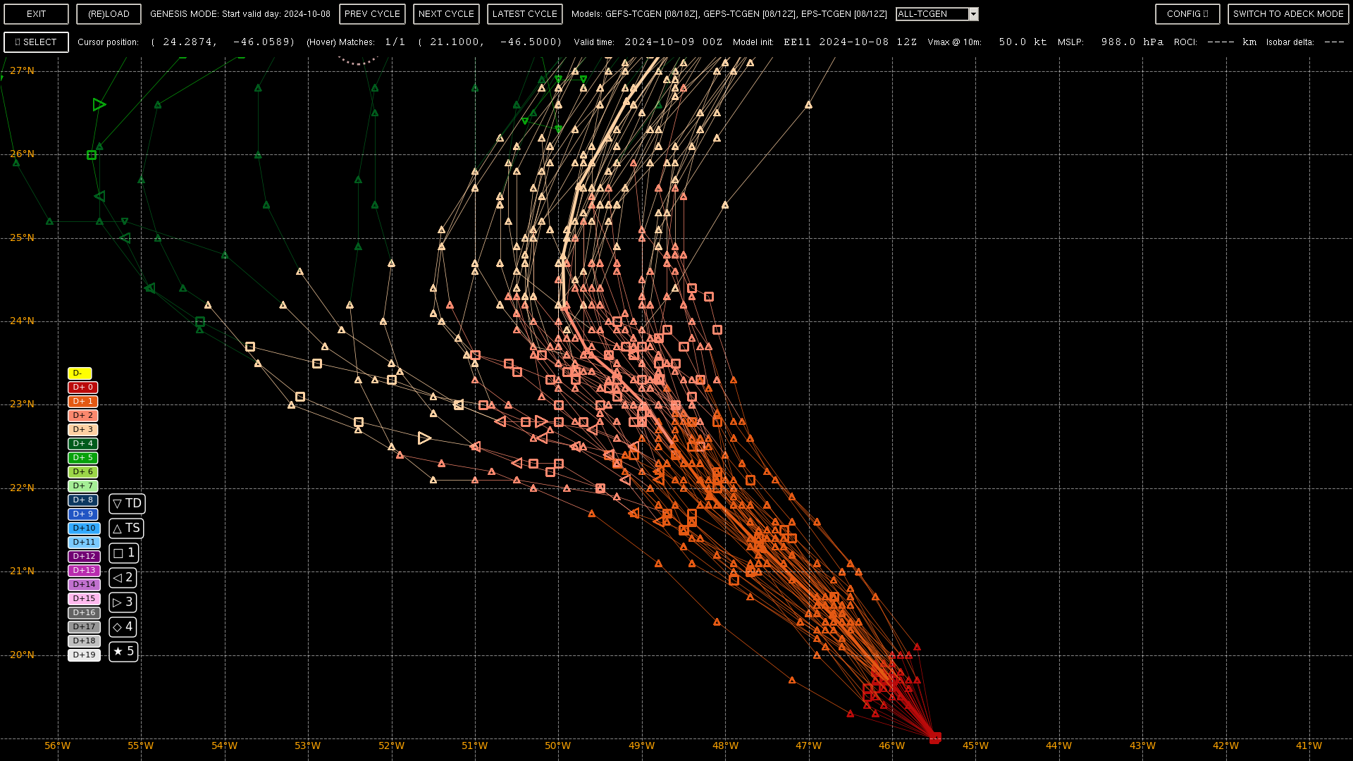
Given it's about to peak in these members in around 36 hours (+- 12); the pruned super ensemble cross track error is about 25 n.miles for this time which seems acceptable for HAFSA,B 12Z.
Checked 18Z, only one of them show it reaching cat. 2, so there doesn't seem to be much reason to bet it up more other than they might be on the lower end considering ADT numbers...
Latest advisory from NHC pushes peak up to 80 kt..... relevant discussion starts with noting a 'touch' west shift in the forecast...
The NHC
track continues to be in good agreement with the track guidance, and
is just a touch west compared to the prior forecast.

Leslie's intensity prospects in the short-term have undergone a
reversal from yesterday. The shear that had been affecting the
hurricane has subsided, and SHIPS guidance now shows deep-layer
shear reaming under 10 kt for at least the next 24 hours. Even
though Leslie has been traveling over a cooler ocean left behind
from Kirk last week, the sea-surface temperatures still appear to be
warm enough (27-28 C) to promote intensification, as evidence of its
continued deep convective bursts which have helped reform its inner
core. The intensity guidance has responded to these changes by now
showing more intensification. In fact, the raw 18 UTC HAFS-A/B runs
now show intensification up to 80-85 kt in 36 hours. In addition,
the latest ECMWF run, not usually known for being at the upper-end
of the intensity guidance, shows significant deepening in the
short-term, with a forecast pressure down to 969 mb by early
Thursday morning. Based on these signals, the intensity guidance was
raised upward significantly in the short term, and now shows Leslie
peaking as an 80 kt hurricane in 24-36 hours. After that time, a
large upper-level anticyclone approaching from the northwest
(partially related to outflow from both AL93 and Milton) should lead
to an abrupt increase in northerly shear. Thus, rapid weakening is
still anticipated beyond that time, and Leslie still appears likely
to become a post-tropical cyclone in about 3 days, as its convection
is stripped away by the shear. The intensity forecast is on the
upper-end of the guidance over the first 36 h, but falls back to the
guidance mean by the end of the forecast period.@parhizj C2 now explicitly forecast:
FORECAST POSITIONS AND MAX WINDS
INIT 09/1500Z 21.7N 48.4W 75 KT 85 MPH
12H 10/0000Z 22.5N 49.2W 85 KT 100 MPH
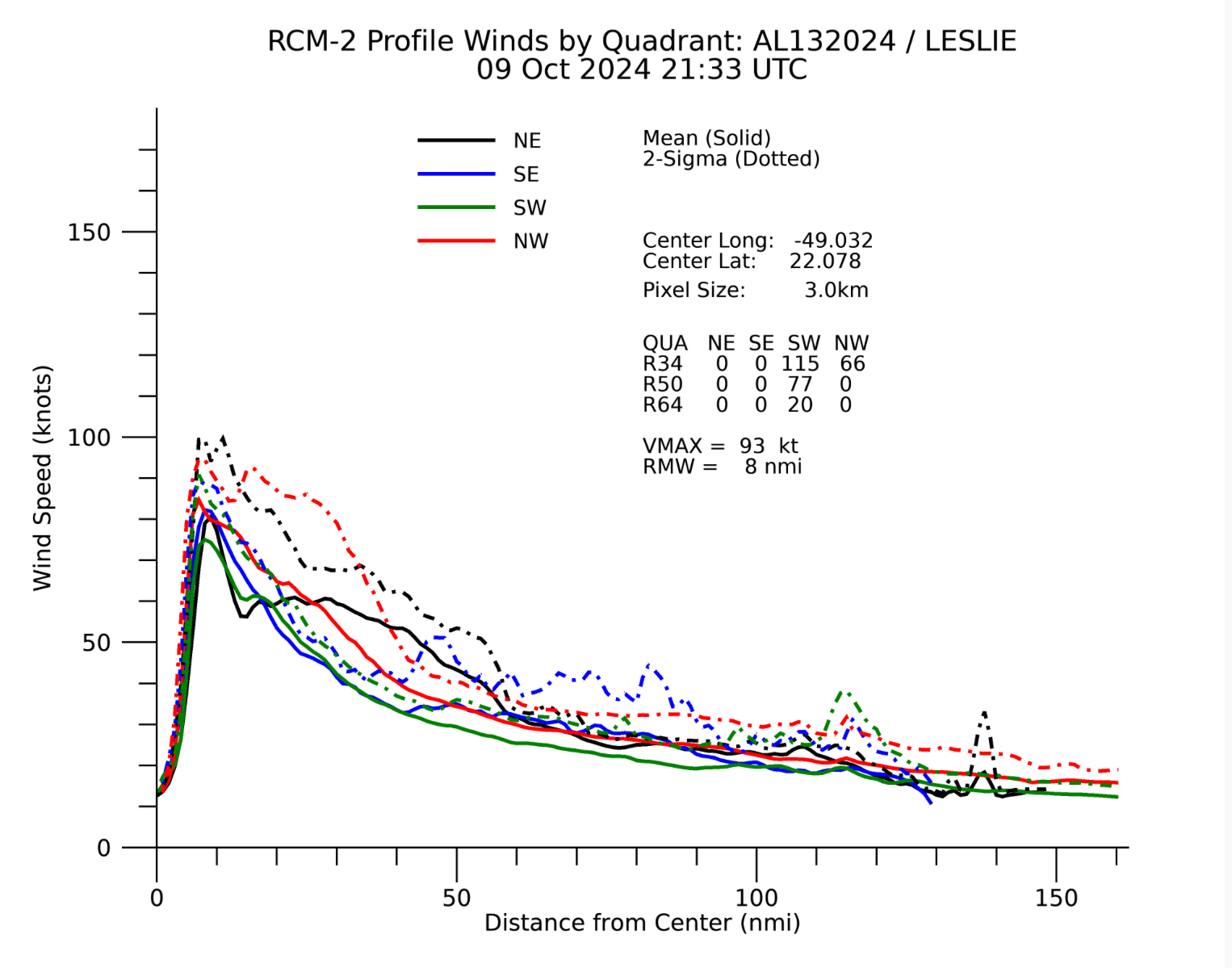
Storm looks intense on satellite, there are frames where you can see the eye starting to clear:
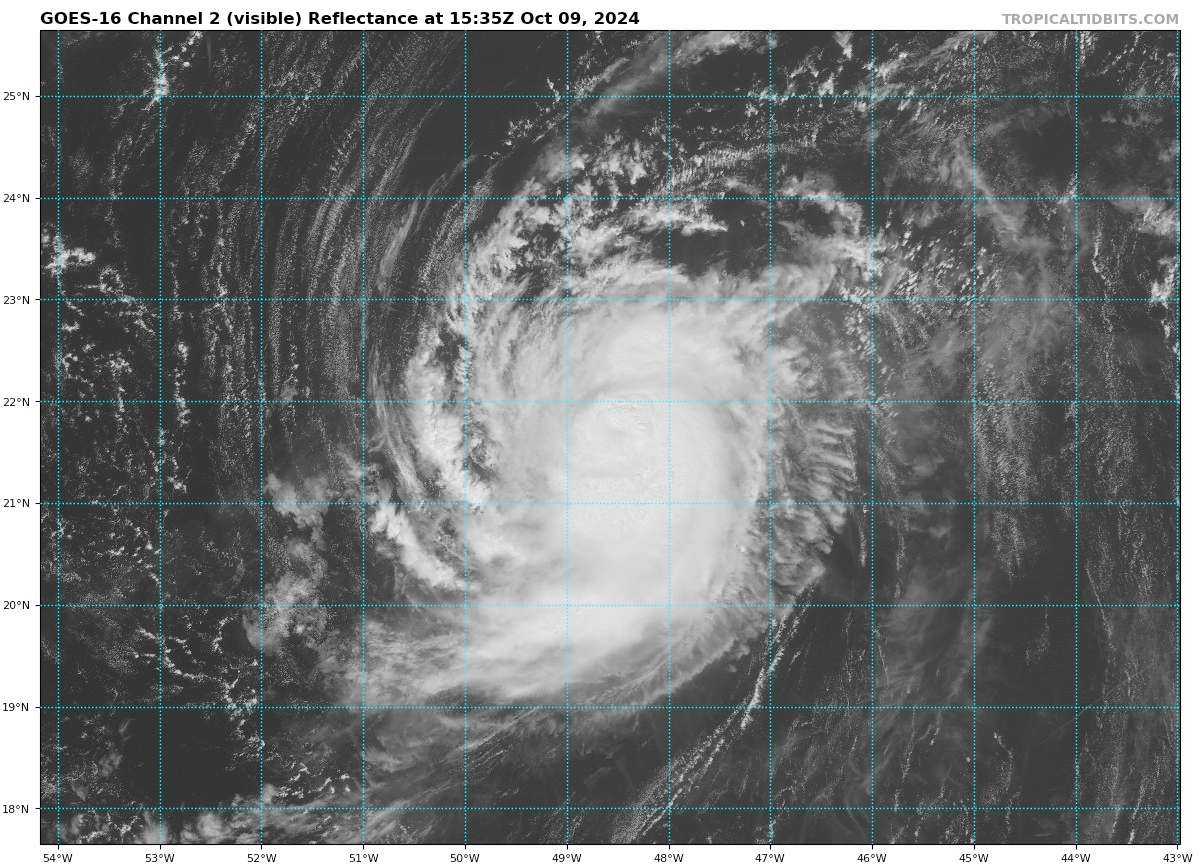
@SaviorofPlant wrote this between 4:30-4:50 and the NHC advisory came out early...
Mean track from ensembles has shifted so it will travel 1 degree further west now. (to 51W); less spread now among the ensemble.
Looks like it will be kept at 80kt for the 5pm advisory (which we are < 30 minutes from) from fixes I've looked at... (ranging from 72-85 kt).
SATCON (85 kt) is above all the individual member estimates though which go up to 82 kt.
Edit: NHC kept it at 80 kt.
EPS/12Z does indicate some strengthening in the next 12 hours is likely:
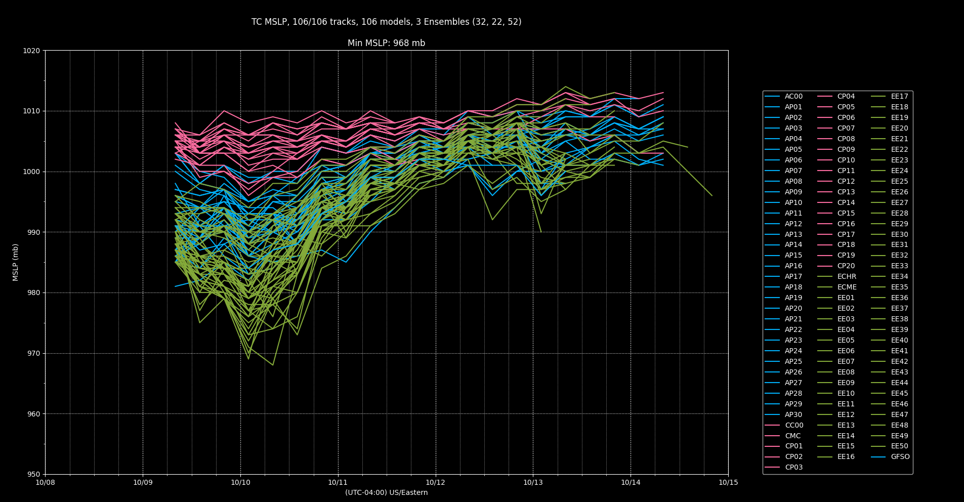
However the chances of it reaching CAT2 (by pressure) have actually decreased ... However, I'm going to base the assumptions about it reaching CAT2 based on the trend rather than the specific intensity at this time since its a 12-24 hours forecast essentially..
The regional models are much more bullish (the exception being HAFS-A) based on this I'm significantly more confident that it will become a cat. 2.
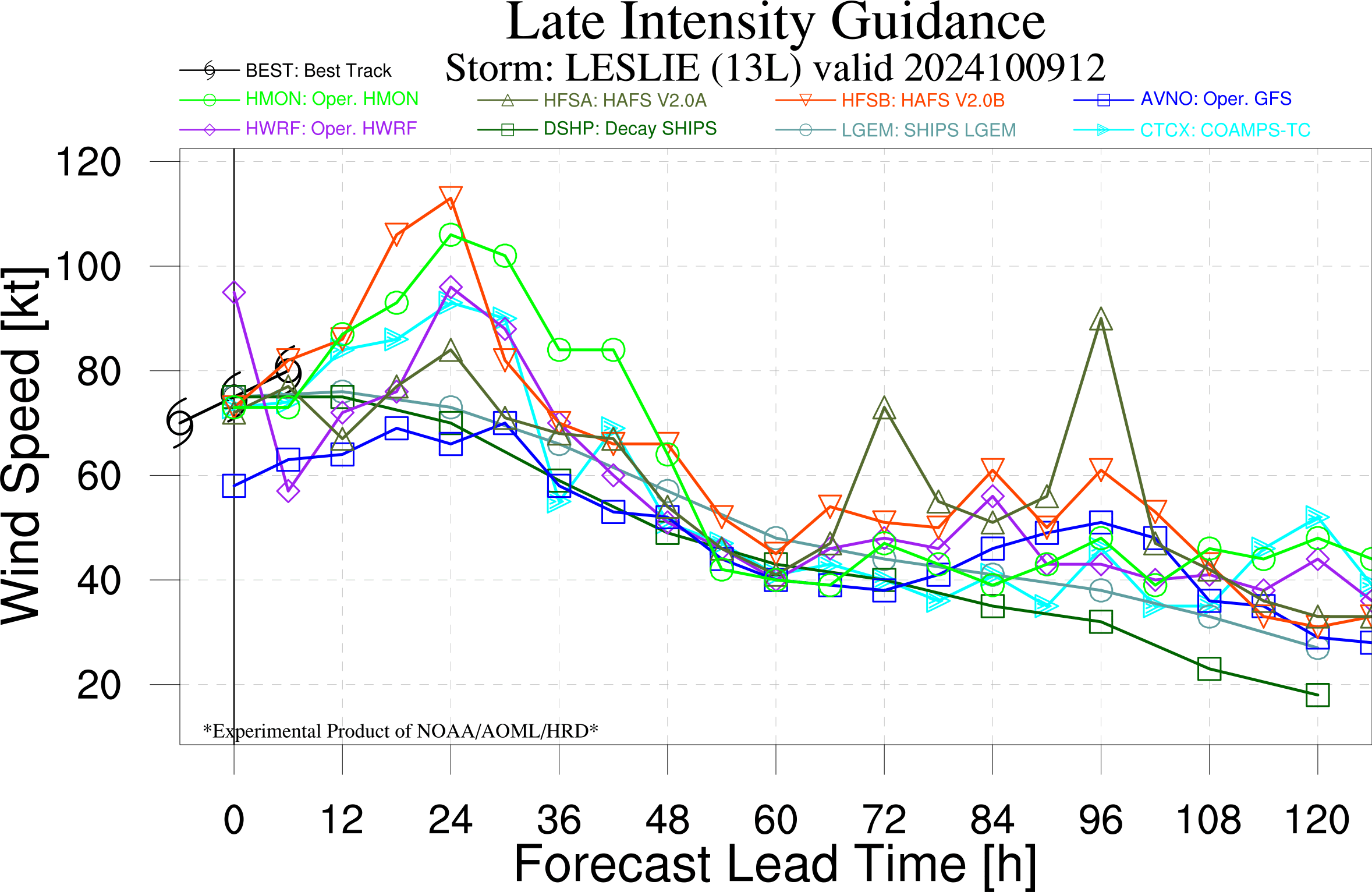
Given the NHC advisory that their will be less shear for the next 12 hours, I speculate that the subjective dvoraks should improve and be less conservative (especially if a clear eye forms...)
The objective ADT shows a recent strengthening trend as well.
This gives a window of about 12 hours where it is likely to reach cat. 2 (the 11 pm tonight and the 5am advisory tomorrow -- this is a narrow window, otherwise I'd bet it up more.
First, NHC, relevant 5AM discussion:
The intensity forecast is the most challenging part of this
advisory.  Deep-layer shear is relatively low at the moment and
should remain so for the next 24 hours or so.  This is the period
where the NHC forecast shows additional strengthening, and is close
to the statistical-dynamical models near the top end of the
guidance.  Increased shear, combined with Leslie potentially moving
over Kirk's cold wake, could cause some weakening after 24 hours.
All of the intensity models support this scenario, however they
differ significantly in how much weakening will occur.  The NHC
forecast continues to show Leslie maintaining hurricane status
through day 5, mainly following the SHIPS model.  However, the IVCN
and HCCA consensus aids, as well as several of the hurricane
regional models, suggest that Leslie could weaken below hurricane
intensity by 48 hours.  Downward adjustments to the intensity
forecast may be required in future advisories if this trend
continues.
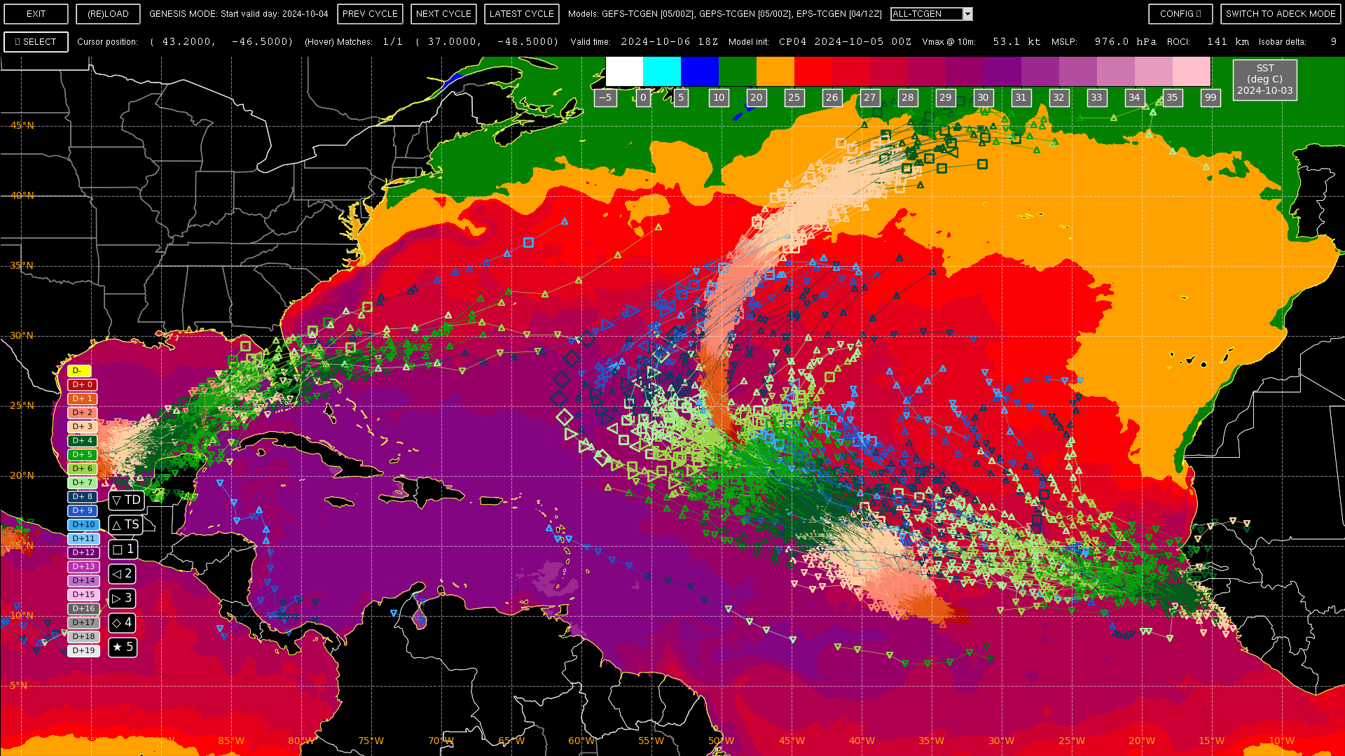
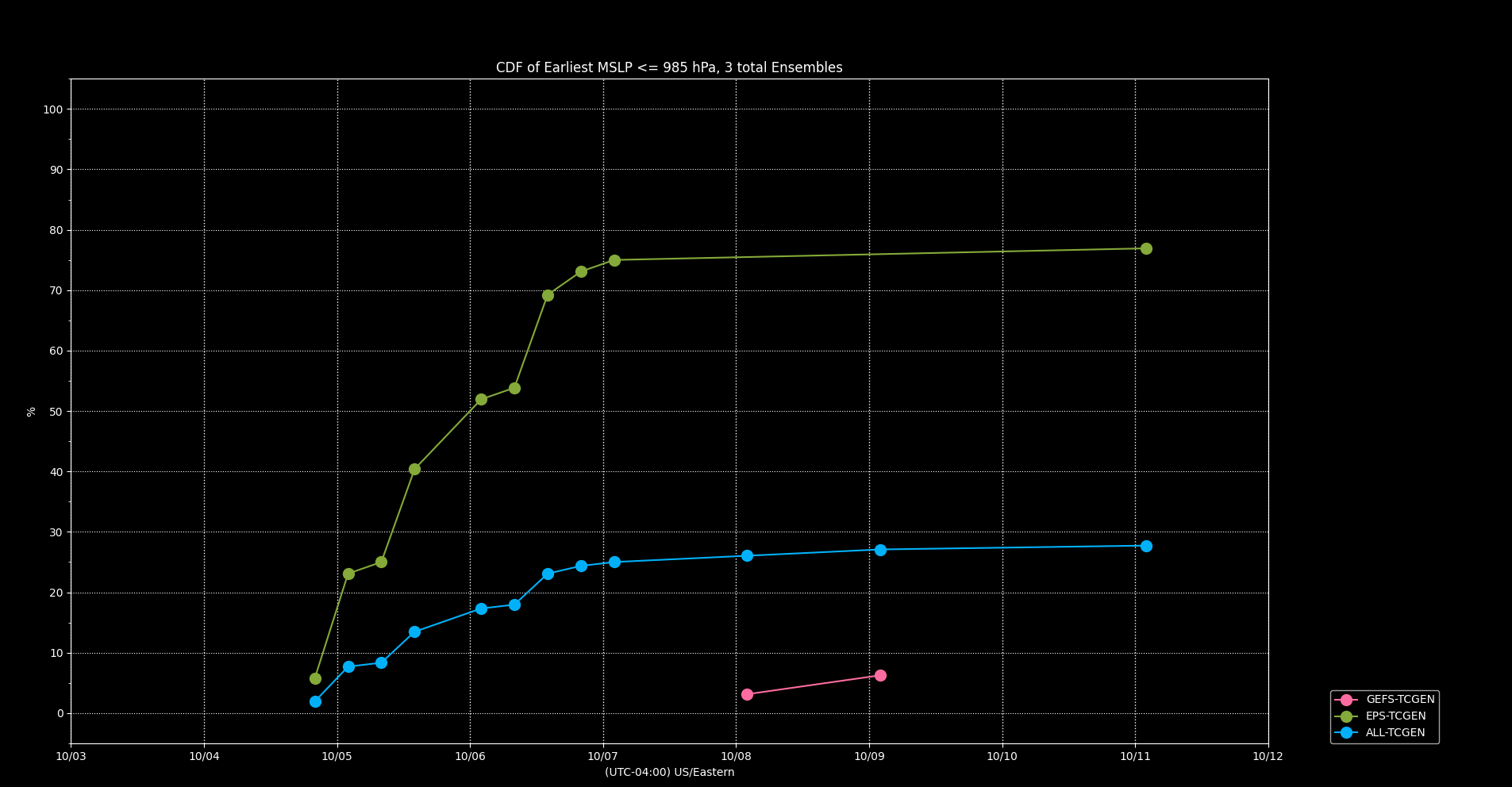
There is more agreement now going out 7 days from the 00Z ensembles (and now seems to roughly or nearly cover the peak intensity), but as I checked EPS against the 5am advisory pressure I noticed that the ensemble is far from a good fit for the current NHC intensity estimate (only ~ 25% of the models at 5 AM (EDT) reach a pressure of 985 hPa by that hour (it would be great if I could prune members that roughly don't fit -- for future work...) ... The lower resolution GEFS/GEPS are nowhere near the pressure as well, which is not surprising....
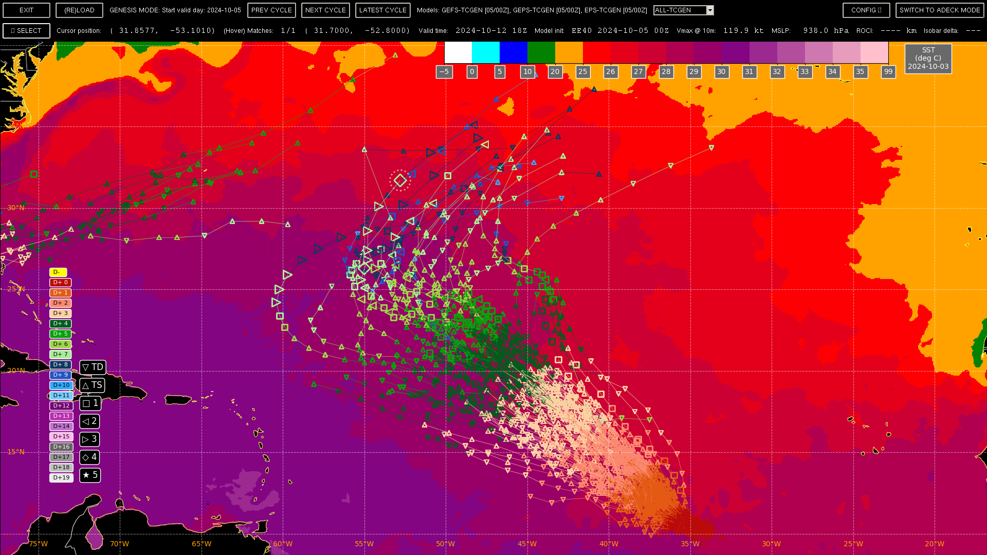
(Above: after removing Kirk's tracks and the disturbance in the East Atlantic. Below: zoomed out with the tracks). Ensemble agree it will mostly follow in Kirk's wake but perhaps recurve slightly more west...
