Hurricane Hilary is currently projected to impact California. Will it make landfall on the coast?
A tropical storm making landfall in California is exceptionally rare. The only recorded instance of this was in Long Beach, 1939.
https://en.wikipedia.org/wiki/1939_California_tropical_storm
The only known hurricane to directly impact California was the 1858 San Diego Hurricane. It is thought that it never made landfall, skimming the coast of the California Bight.
https://en.wikipedia.org/wiki/1858_San_Diego_hurricane
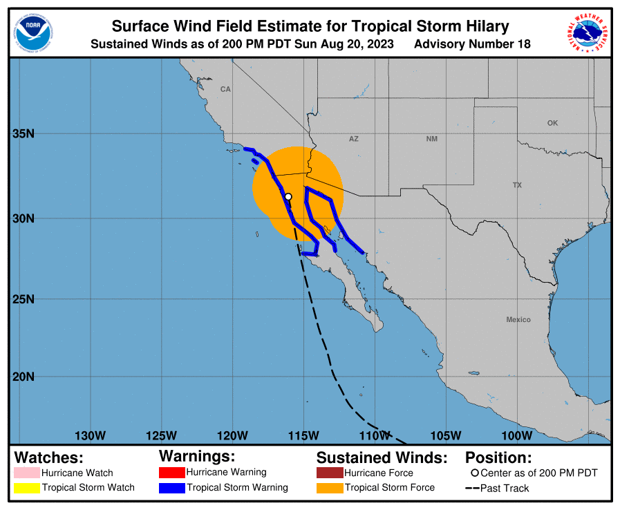
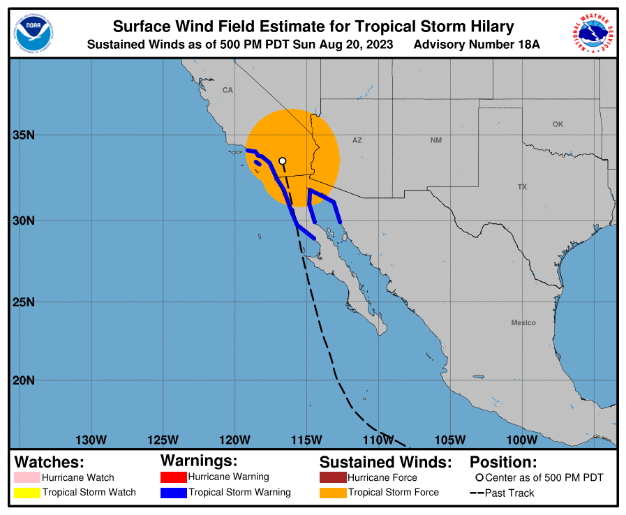
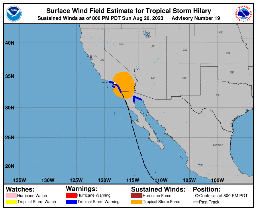
National Hurricane Center definition of landfall: "The intersection of the surface center of a tropical cyclone with a coastline." (For this, we'll also count the center of a subtropical storm making landfall on the California coast.)
Will resolve by the end of Monday, 8/21
EDIT: Due to the very close call and NHC's difficulty tracking the center of the storm, this will resolve sometime in early September when the NHC's best track analysis is released.
 1,000
1,000🏅 Top traders
| # | Trader | Total profit |
|---|---|---|
| 1 | Ṁ808 | |
| 2 | Ṁ453 | |
| 3 | Ṁ245 | |
| 4 | Ṁ217 | |
| 5 | Ṁ157 |
People are also trading
Best track is out. By my reading this can finally resolve NO now:
https://www.nhc.noaa.gov/data/tcr/EP092023_Hilary.pdf
“Although the center of Hilary did not move into the United States “ (bottom of pg6)
Also was considered post tropical when it was over Mexico (middle of pg.4).
They do note and discuss about the low off of San Diego that was commented on during the time this market became uncertain whether it would make landfall in California whether it was Hilary or not, but in the best track re analysis it was already considered remnants by the time it degenerated into a low and the remnants reabsorbed by the low off of San Diego Fig.6).
@parhizj I could message her on twitter but I don't think she cares enough about "wanting to do it herself" that it's needed/ So I will just resolve it
@Rachell Can you please resolve this question?
According to the Wikipedia article, it made landfall in Baja California, not California
@bohaska if you read the comments and the description, question creator will wait until best track. This will take time ... (months?)
@Rachell I'm not gonna complain either way, since it's technically in doubt and I've gotten used to eating cat food. If you do resolve NO and later it seems it should have been YES, I will donate 2k mana to a good cause, like maybe the Longhopes Donkey Shelter in Bennett, Colorado (I would donate to a Burro charity but there has been some bad blood between us since one bit my sister a couple of years ago)
Only Tropical depression 4E listed at
https://www.nhc.noaa.gov/data/tcr/index.php?season=2023&basin=epac
My impression is it could be months before they get around to it if current forecasting keeps them busy. (Just because page says updated monthly doesn't mean that all of the storms and hurricanes in the last month will be updated. But there could easily be better info on timing of updates that I am not aware of.)
This is why I'm reluctant to resolve. Images are from NHC's preliminary best track GIS, line drawn by me. This preliminary track has 0000 and 1800 UTC data points and NHC's best track product (which releases in early September) uses 0000 and 1200 UTC. Also the "best track" may shift. Considering the westward slide that occurred during NHC's forecast track on Sunday, I think some sort of shift may be in the cards.


@Rachell I fully understand that the storm didn't move in a straight line from point to point, but it was pretty clear that NHC had some difficulty tracking the center as the storm became less organized. Here's where they slid the storm's center from the middle of the wind field to the western edge of the wind field. I'm going to try to reach out to a forecaster at the NHC for some more clarity. Will try to keep the "people are gambling donation-fungible fake dollars" aspect out the convo.
@Rachell Worst case, we wait until next year, when the re-analysis data is entered into the database. There it shows for each observation whether it crossed the coastline (they put an L after each entry):
https://www.nhc.noaa.gov/data/hurdat/hurdat2-format-nencpac-1949-2021.pdf
Actually, it looks like the PDF's out next month for the final best track will answer that question. (Should be in the stage column) https://www.nhc.noaa.gov/data/tcr/index.php?season=2023&basin=epac
@Rachell here is a recap citing NHC saying NO: "While Hilary did not make landfall in southern California, it did make landfall over the northern Baja California Peninsula in Mexico as a tropical storm on Sunday according to the NHC" https://www.climate.gov/news-features/event-tracker/former-hurricane-hilary-brought-southern-california-its-first-ever
@AlQuinn I think that is pretty definitive.
@Rachell see my comment below: https://manifold.markets/Rachell/will-hurricane-hilary-make-landfall#zGTblgxN0GbUzRrF2NlX
@Rachell so far, the only hits for CA landfall are MSM articles that are clearly ignorant of the NHC definition of that term. I'm not sure if the wind field map from NHC is stylized in any way or if it even purports to track the actual storm center versus their products that are intended to specifically do so.
@Rachell also not sure if you saw this other Hilary market on Rain > 3" in downtown LA. Rain total was 2.99" lol https://manifold.markets/DocTobogganMD/will-downtown-los-angeles-get-more?r=QWxRdWlubg

@Rachell You can always wait for the final track in a month or so but I have a feeling they won’t change their mind about it making landfall.
So this resolves to yes, right?
https://www.npr.org/2023/08/20/1194908447/tropical-storm-hilary-southern-california

@parhizj So are you only basing it on where the center of a few hundred miles in diameter storm lands? Because by the time it makes landfall in Mexico the US has been hit by the outer rain bands for hours.
@DavidSchwartz I haven’t been able to keep up with all the updates and comments, been a busy weekend. But I’ve felt the original question didn’t 100% jive with the description. The question said to me, “Will Hilary still be tropical storm strength when it makes landfall in California?” And not, “Will Hilary make landfall on the California coast before anywhere else in the region?”
I’ll let it resolve with the caveat emptor, I guess. Should have known with its high likelihood of plowing through Baja California that the landfall would have been long past by the time it hit US territory.
Landfall is a widely used technical term which clearly defined. It means the strongest winds the storm coming on to land from sea/ocean.
Landfall: The intersection of the surface center of a tropical cyclone with a coastline. Because the strongest winds in a tropical cyclone are not located precisely at the center, it is possible for a cyclone's strongest winds to be experienced over land even if landfall does not occur.
https://www.nhc.noaa.gov/aboutgloss.shtml#:~:text=Landfall%3A,if%20landfall%20does%20not%20occur.
"Coastline" is clearly a requirement.
@ChristopherRandles Fair, though I have seen some very specific perspectives on terms here to ensure questions resolve one way or another.
Hilary made landfall over the northern Baja California Peninsula a
few hours ago with maximum winds estimated to be around 55 kt.
https://www.nhc.noaa.gov/archive/2023/ep09/ep092023.discus.018.shtml?
"Baja California Peninsula" is Mexico not California
The Baja California peninsula is a peninsula in northwestern Mexico.
@DavidSchwartz The issue is where are you going to get data for the center of the storm per the definition of the question. The NHC goes by minimum surface pressure/wind to estimate the vertical axis of the storm, and the only authoritative estimates I have seen come from the public advisories from the NHC which were every 3 hours ( the estimates for position AFAIK are themselves done by the Miami branch of the NHC - TAFB : https://twitter.com/NHC_TAFB). Unfortunately they don’t make their position data public so we have to rely on NHC advisories. None of the advisories AFAIK show it crossing the coastline ( if you interpolate between advisories).
Yesterday I thought there was a chance of it blipping westward in time to cross the coastline for the 5pm PST advisory, but it didn’t do so. It did blip later on 3 hours later in the 8pm PST advisory https://www.nhc.noaa.gov/refresh/graphics_ep4+shtml/084954.shtml?gm_track#contents where it came very close to the California shore (less than the margin of error) but as it was already inland prior I don’t think you can make the case that this was a (second) landfall as in interpolating between them it didn’t cross the shore.
@DavidSchwartz Thanks for that link.
The (preliminary) best track for Hillary unfortunately is only every 6 hours. I believe the same will be the case for the final versions in a month or so after looking at one of them. The intermediate advisories had position data in between these times so I find that is more useful.
Edit deleted
I added the NHC advisories only for the same period (as octagons on the map) 1800 and 0000 utc so you can see the difference between the two data sets (the red hurricane symbols are the preliminary best track)
Even though it looks like on the preliminary best track it is crossing the California coast barely I think this is more an artifact of the low time resolution (6hrs between samples.) I would defer to authoritative summaries in this case.
Edit : purple line I’ve added