As of July 1, 2023, the eastern Pacific Ocean, whose season officially began on May 15, 2023, has spawned two named storms: Adrian and Beatriz.
The Atlantic Ocean thus far has spawned three: Arlene, Bret, and Cindy.
This market will not count anything but names. No depressions, no extra points for achieving hurricane strength. A man desires only names.
Typhoons in the western Pacific Ocean will not count towards Pacific Ocean total.
All tropical cyclones named prior to the official season end will count for totals.
Tracking link: https://www.nhc.noaa.gov
 1,000
1,000🏅 Top traders
| # | Trader | Total profit |
|---|---|---|
| 1 | Ṁ80 | |
| 2 | Ṁ42 | |
| 3 | Ṁ30 | |
| 4 | Ṁ7 | |
| 5 | Ṁ0 |
People are also trading
Listening to the NOAA press conference:
NOAA Aug. 10 update:
14-21 named storms.
6-11 Hurricanes
2-5 Major Hurricanes
Less wind shear in some of the models now.
https://www.noaa.gov/news-release/noaa-forecasters-increase-atlantic-hurricane-season-prediction-to-above-normal
https://www.nhc.noaa.gov/climo/
It is now July 14.
Comparing now to the average:
Atlantic: 4 storms now: ~1 month ahead for an avg. 14 storm season. Don (named July 14) versus August 15 avg.
Pacific: 3 storms now: ~1 week behind for an avg. 15 storm season. Calvin (named July 12) versus July 6 avg.
Bet notes: 200 days spanning the two seasons. (updating daily: 100 M bankroll, updating equally daily: =0.5 Mana bet daily * 61.5 days passed = 31 M; bet 20 already: 31-20 = 10M bet)
It is now Aug 3.
Atlantic:
CSU update has forecasted 17 named storms in the Atlantic ( they include an unnamed one in their total of 18). I mentioned before 18 but it is actually 17 since they counted an unnamed one in their total.
Haven’t had a named storm since last update but it is still 12 days ahead for a 14 storm season.
Pacific:
With only 4 storms so far and Dora forming Aug. 1, it is 17 days behind from a 15 storm season. (There should be 6 storms by now for a 15 storm season)
A bit dated ( 2 says ago, before Dora):
https://www.nhc.noaa.gov/text/MIATWSEP.shtml
In terms of Accumulated Cyclone Energy (ACE), which measures the
combined strength and duration of tropical storms and hurricanes,
2023 is well below the long-term (1991-2020) average.@parhizj
Eastern Pacific Update: Eugene forms (August 5)
Now with 5 storms so far, it is 13 days behind an average 15 storm season.
@parhizj
https://www.nhc.noaa.gov/archive/2023/ep07/ep072023.public.002.shtml
Eastern Pacific Update:
Fernanda formed yesterday (Aug. 12)
Now with 6 storms so far it is now 9 days behind an average 15 storm season. (There should be 7 storms by Aug. 11 for a 15 storm season).
The count for Eastern Pacific has closed the gap a bit with the Atlantic. The Atlantic has a low chance of forming it's fifth named storm in the next 7 days to be on track for a 14 storm season (20% chance from 7 day outlook).
Based on this I've decided to place a small bet on a tie for now.
@parhizj
Eastern Pacific:
https://www.nhc.noaa.gov/archive/2023/ep09/ep092023.public.001.shtml?
Hilary formed a couple days ago (Aug. 16). That puts its ahead now of a 15 storm season.
Atlantic:
The fifth named storm has still not formed, although there are 4 places of interest in the current outlook: https://www.nhc.noaa.gov/?atlc One with a 60% chance of forming in 48 hours and 70% chance of forming in 7 days. Presently the Atlantic has fallen behind a bit now and is currently on track for a 14 storm season now. Even if it takes a week for the next named storm to develop it will be behind a 14 storm season.
Based on this I will update to buy more Atlantic & Tie shares.
Atlantic update:
Emily formed today Aug. 20 (#5) making it 2 days ahead of a 14 storm season. There is a disturbance in the Eastern Caribbean that NHC gives (Edit) 90% chance of developing). ECMWF puts the disturbance of having TS winds at 50% by Saturday Aug. 26 (that would keep it roughly in the same schedule if it does develop Saturday or soon after):
Edit: Pacific:
Nothing likely for development in either 7day NHC or 12day ECMWF forecast for development . If nothing develops that would put it back behind schedule for a 15 storm season (by about 7 or so days or by 1 storm)
Atlantic update (again)
Franklin ALSO formed today Aug. 20 (#6) making it 9 days ahead of a 14 storm season.
There is also a second disturbance east of Emily: NHC 70% chance of development in 7 days, with ECMWF having it more specifically at 30-40% of becoming a TS (it may only become a TD)
Atlantic update:
Gert formed today (#8) Aug. 21 (midnight last night)
https://www.nhc.noaa.gov/archive/2023/al06/al062023.public.007.shtml
That puts it 14 days ahead of schedule of a 14 storm season (where we would normally see it on average on Sep. 3).
A disturbance east of Emily NHC puts at 70% of becoming a TD over 7 days. (still 30-40% for TS on ECMWF). There is a disturbance in the Gulf of Mexico that is forecast to become a TD (but ECMWF puts the chances of a TS at < 10%)
Atlantic update:
Harold formed this morning (#9) on Aug 22, in the Gulf of Mexico. https://www.nhc.noaa.gov/archive/2023/al09/al092023.public_a.003.shtml?
I realized this question considers only the hurricane season so I (probably?) shouldn't include the unnamed Atlantic storm I suppose in the named storms even though CSU does that. (That makes the counts earlier off by 1 -- too much work to go back and change all the previous numbers).:
Pacific update:
Irwin formed today (#9) August 27 putting it roughly on track for a 15 storm season
Atlantic update:
Idalia also formed today (#9) August 27, putting it roughly 20 days ahead for a 14 storm season (where we would normally have about 7 storms by now).
Atlantic update:
Lee formed today (#12) September 5, putting it so far ahead … I don’t know if I should keep doing these updates . Edit: ok, I will keep doing them… Lee is 36 days ahead of an average 14 storm season.
@parhizj I’m following. I like the ping because it helps remind me I’ll have to resolve come November. Hate that I’m not participating but I try not to in the markets I create
Atlantic update:
Margot formed today (#13) September 7, putting it 48 days ahead of an average 14 storm season.
Atlantic update:
Ophelia formed today (#15) September 22. It is now definitively an above average season (relative 1990-2020).
With 69 days still left until the end of both the hurricane seasons it is Atlantic 15 vs Eastern Pacific 11. NHC forecasts TC genesis in both basins in the next 7 days.
@NicoDelon EP had 5 named storms in October (normal would be 3) so it was able to catch up quite a bit late in the season
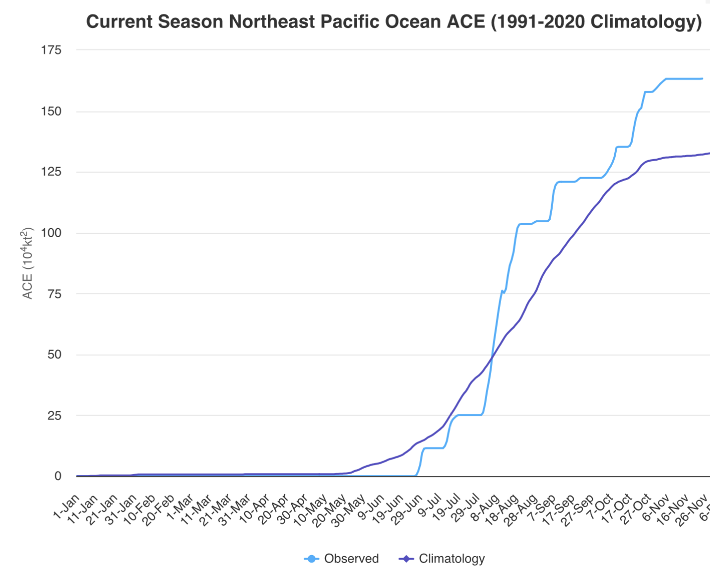
ACE From CSU (https://tropical.atmos.colostate.edu/Realtime/index.php?loc=northeastpacific)
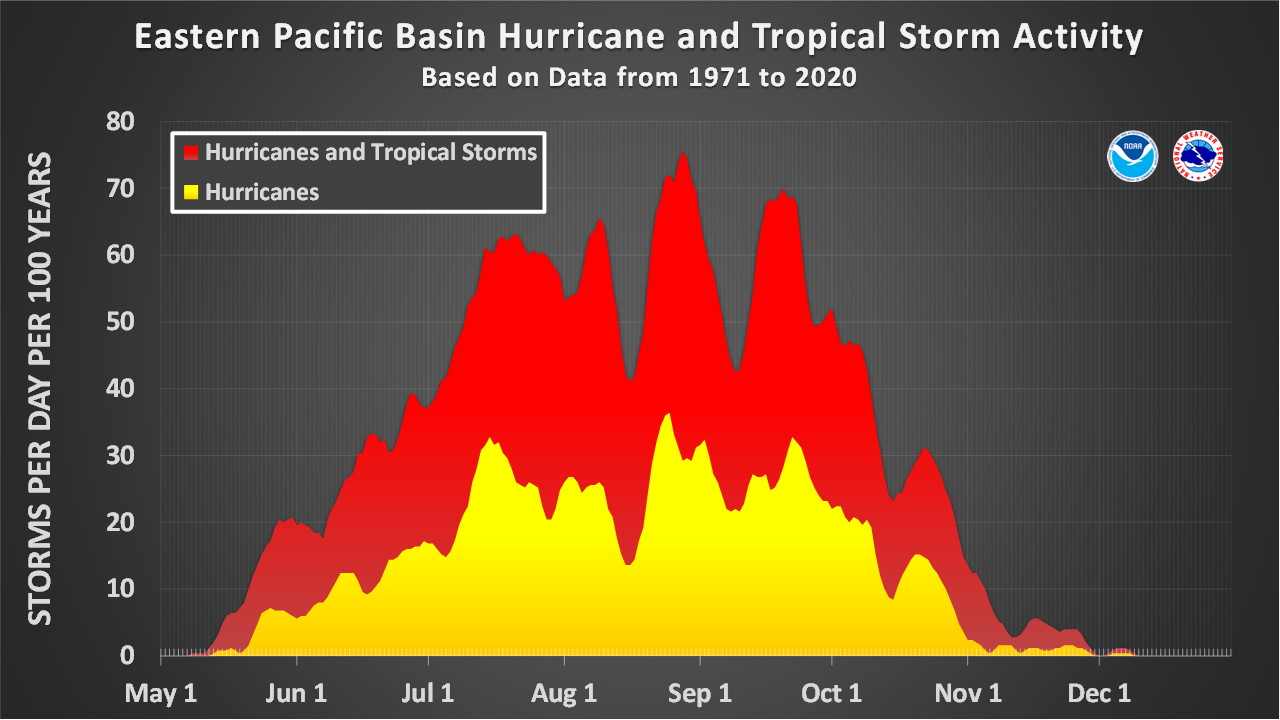
Named storm days climatology from NOAA:
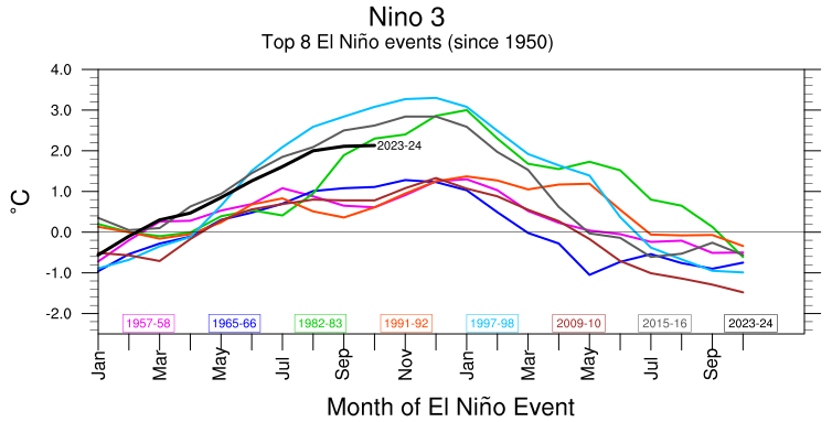
and I would bet El Niño surely contributed (putting October in top 4 for Niño 3 index in last ~70 years)