Resolves YES if at any point Tropical Storm Idalia reaches Cat. III strength as defined by the National Hurricane Center.
 1,000
1,000🏅 Top traders
| # | Name | Total profit |
|---|---|---|
| 1 | Ṁ501 | |
| 2 | Ṁ186 | |
| 3 | Ṁ130 | |
| 4 | Ṁ105 | |
| 5 | Ṁ84 |
People are also trading
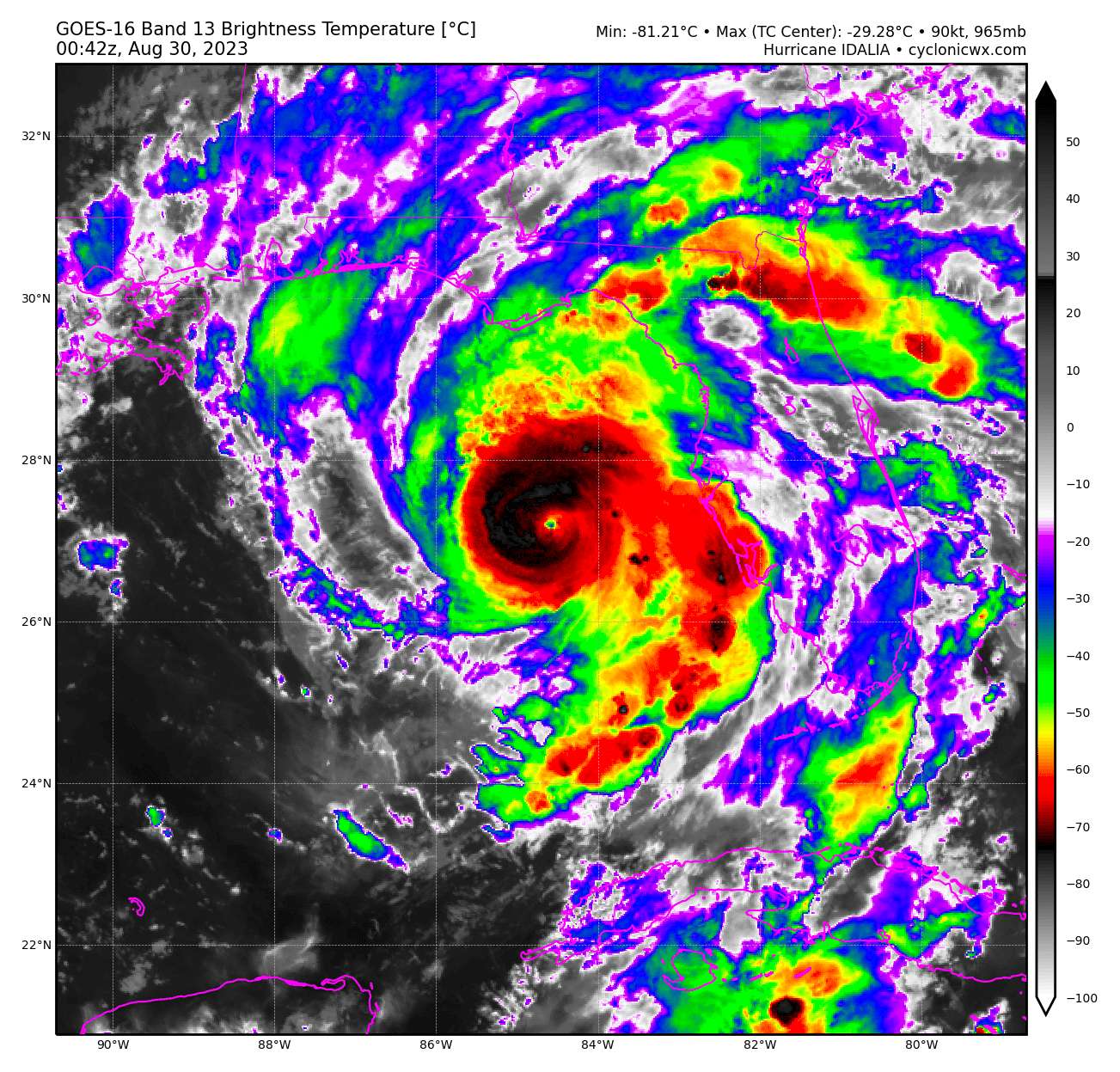
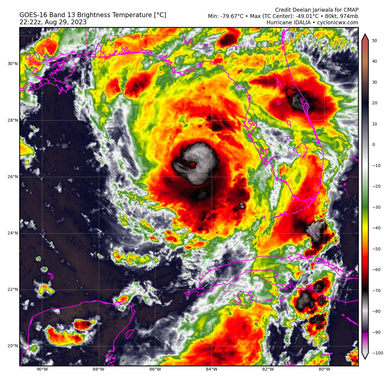
Hurricane Hunter aircraft data indicate that maximum sustained winds have increased to near 120 mph (195 km/h) with higher gusts. Idalia is a category 3 hurricane on the Saffir-Simpson Hurricane Scale. Additional strengthening is forecast, and Idalia is forecast to become a category 4 hurricane before it reaches the Big Bend coast of Florida this morning. Idalia is likely to still be a hurricane while moving across southern Georgia, and possibly when it reaches the coast of Georgia or southern South Carolina late today. From here.
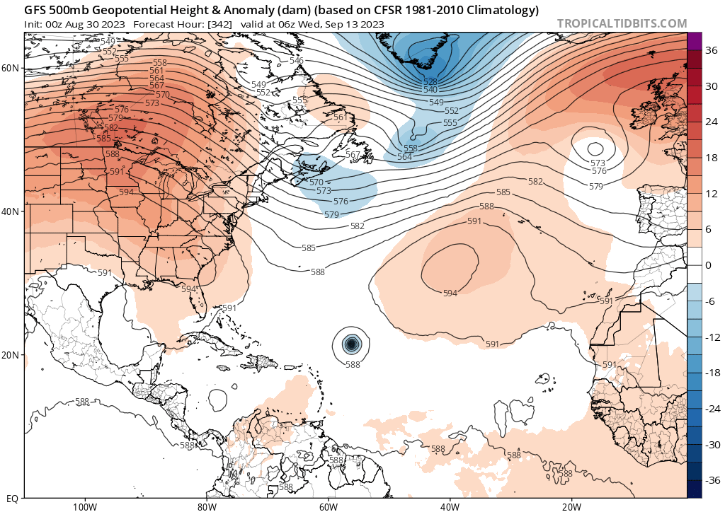
@parhizj Thanks for the tip! I think we did a pretty good job with this storm. Let's hope the 2023 season is already out of steam... I'm not so sure, though. Genesis forecasts are usually pretty meh (<30% verify when 5 days out) but the models (Euro Ensembles, CMC & GFS deterministic) are already picking up some signals, just as waves are coming off Cape Verde... Peak season is around the corner and the MDR might pop off. Don't think these will be a big risk to the U.S. for now - but definitely worth keeping an eye on.


@sarius New advisory: winds at cat 4 (115 kt)
https://www.nhc.noaa.gov/text/refresh/MIATCMAT5+shtml/300856.shtml
Is there a difference between Idalia becoming a Cat III and it hitting Florida as a Cat III? Like is it because the hurricane slows down as it hits land?
@PC I am reading that the warm waters of the Gulf of Mexico helps with the intensification. The measurement of the hurricane hitting land is when "the major hurricane's surface center meeting the coastline", I imagine as hits land, the hurricane slows down and might downgrade?
nvm
nvm
@PC The ECMWF has had the worst performance for intensity for Idalia…. As I know from losing 1k of mana on it already 😭
@PC The ECMWF (Euro) provides forecasts at specific time intervals, while reconnaissance data provides a snapshot of the current conditions at the time of measurement (live from NOAA and Air Force planes, available here). Deviations from the actual data are especially likely with the Euro's poor track record on Idalia and its steady underestimating of its intensity...
Global dynamic models like the Euro rely on a lot of (global) initial atmospheric conditions/assumptions. Small errors in the model physics or initial conditions (like getting wind shear direction slightly wrong) then lead to big discrepancies between model forecasts and real-time observations.
Though, a lot of their seeming incompetence this is due to tropical cyclones simply being too small for to the model resolution to predict properly. Eyewall replacement, rapid intensification/weakening, intrusion of dry air and land interaction are also just really hard to forecast and regional-dynamical models usually have a per-point compute/resolution advantage. They are also, because of that, generally just not quite that good at intensity forecasts. The NHC doesn't actually consider them for its intensity forecasts iirc.
They are much better (sometimes even best in class) when it comes to track forecasts, though!
New intermediate advisory 105 mph
BULLETIN
Hurricane Idalia Intermediate Advisory Number 13A
NWS National Hurricane Center Miami FL       AL102023
800 PM EDT Tue Aug 29 2023

...IDALIA CONTINUES TO STRENGTHEN...
...LIKELY TO BECOME A MAJOR HURRICANE SOON...


SUMMARY OF 800 PM EDT...0000 UTC...INFORMATION
----------------------------------------------
LOCATION...26.9N 84.7W
ABOUT 155 MI...250 KM WSW OF TAMPA FLORIDA
ABOUT 245 MI...390 KM S OF TALLAHASSEE FLORIDA
MAXIMUM SUSTAINED WINDS...105 MPH...165 KM/H
PRESENT MOVEMENT...N OR 10 DEGREES AT 16 MPH...26 KM/H
MINIMUM CENTRAL PRESSURE...965 MB...28.50 INCHES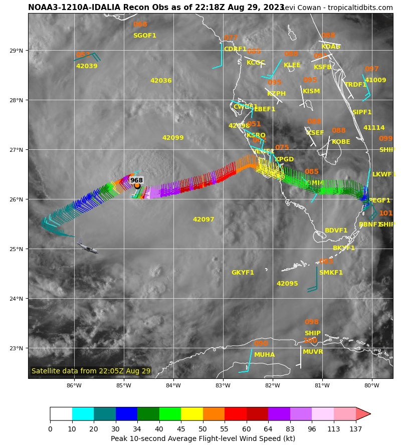


@nmehndir rn around 33% - but I am rather uncertain about that. Might just make it to Cat IV right before land fall. Intensification seems set to keep up. Low-end Cat IV might be hardish to distinguish from a Cat III too - so IDK...
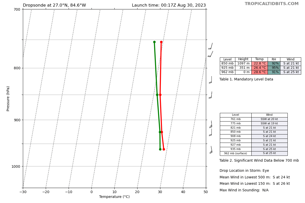
@PC yeah, surface level pressure inside of the eye is what we want. This one apparently didn't hit the surface while taking in wind data. Other drops will have usually have a surface + winds reading.
@sarius that's odd. You could consider creating a Cat IV market. I would put it at 30% too, but I don't know which models are most accurate
@PC I’d rather see a question for Saola hitting Hong Kong as a major Hurricane… Going to sleep
@sarius Intensification is indeed keeping up, probably until or very close to landfall. More likely a Cat IV than a Cat III now... :///
@sarius Just FYI - you have been updating faster than Kalshi, which is why I was confused. It is up at 70% now https://kalshi.com/markets/hurcat/hurricane-category#hurcat-idalia