Will Tropical Storm Iona form in 2025? (CP)
4
Ṁ1kṀ771resolved Jul 28
Resolved
YES1H
6H
1D
1W
1M
ALL
Will Tropical Storm Iona form in 2025? (CP)
Resolution source: https://www.nhc.noaa.gov/archive/2025/
Subtropical storm also counts.
Resolves to advisory text time, UTC.
N/A if does not form in 2025.
This question is managed and resolved by Manifold.
Market context
Get  1,000 to start trading!
1,000🏅 Top traders
| # | Trader | Total profit |
|---|---|---|
| 1 | Ṁ211 | |
| 2 | Ṁ48 | |
| 3 | Ṁ0 |
Sort by:
WTPA31 PHFO 280230
TCPCP1
BULLETIN
Tropical Storm Iona Advisory Number 4
NWS Central Pacific Hurricane Center Honolulu HI CP012025
Issued by NWS National Hurricane Center Miami FL
500 PM HST Sun Jul 27 2025
...IONA BECOMES THE FIRST NAMED STORM OF THE SEASON IN THE CENTRAL
PACIFIC...
SUMMARY OF 500 PM HST...0300 UTC...INFORMATION
----------------------------------------------
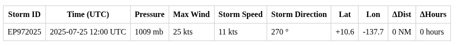
LOCATION...10.9N 148.3W
ABOUT 960 MI...1545 KM SE OF HONOLULU HAWAII
MAXIMUM SUSTAINED WINDS...40 MPH...65 KM/H
PRESENT MOVEMENT...W OR 270 DEGREES AT 10 MPH...17 KM/H
MINIMUM CENTRAL PRESSURE...1005 MB...29.68 INCHES
WATCHES AND WARNINGS
--------------------
There are no coastal watches or warnings in effect.
DISCUSSION AND OUTLOOK
----------------------
At 500 PM HST (0300 UTC), the center of Tropical Storm Iona was
located near latitude 10.9 North, longitude 148.3 West. Iona is
moving toward the west near 10 mph (17 km/h). This motion is
expected to continue for the next few days, with Iona remaining
well to the south of the Hawaiian Islands.
Maximum sustained winds are near 40 mph (65 km/h) with higher gusts.
Steady strengthening is forecast during the next couple of days.
Tropical-storm-force winds extend outward up to 35 miles (55 km)
from the center.
The estimated minimum central pressure is 1005 mb (29.68 inches).
HAZARDS AFFECTING LAND
----------------------
None.
NEXT ADVISORY
-------------
Next complete advisory at 1100 PM HST.
$$
Forecaster Jelsema (CPHC)ACPN50 PHFO 251149
TWOCP
Tropical Weather Outlook
NWS Central Pacific Hurricane Center Honolulu HI
Issued by NWS National Hurricane Center Miami FL
200 AM HST Fri Jul 25 2025
For the central North Pacific...between 140W and 180W:
Well Southeast of the Hawaiian Islands:
An area of low pressure located well southeast of the Hawaiian
Islands is producing a large area of showers and thunderstorms.
Some gradual development of this system is possible, and a tropical
depression could form late this weekend or early next week as it
moves generally westward at 10 to 15 mph across the far western
portion of the eastern Pacific and into the Central Pacific basin.
* Formation chance through 48 hours...low...20 percent.
* Formation chance through 7 days...medium...50 percent.Could form in the EPAC first (in which case this system won't be named Iona) or could not form at all.
Now an invest (EP97) for it.
Edit:
Now CP90:
CP90 has become a tropical depression:
BULLETIN
Tropical Depression One-C Advisory Number 1
NWS Central Pacific Hurricane Center Honolulu HI CP012025
Issued by NWS National Hurricane Center Miami FL
1100 PM HST Sat Jul 26 2025
...TROPICAL DEPRESSION ONE-C FORMS WELL TO THE SOUTHEAST OF THE
HAWAIIAN ISLANDS...
SUMMARY OF 1100 PM HST...0900 UTC...INFORMATION
-----------------------------------------------
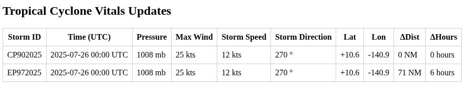
LOCATION...10.9N 145.6W
ABOUT 1085 MI...1745 KM SE OF HONOLULU HAWAII
MAXIMUM SUSTAINED WINDS...35 MPH...55 KM/H
PRESENT MOVEMENT...W OR 270 DEGREES AT 12 MPH...19 KM/H
MINIMUM CENTRAL PRESSURE...1009 MB...29.80 INCHES
WATCHES AND WARNINGS
--------------------
There are no coastal watches or warnings in effect.
DISCUSSION AND OUTLOOK
----------------------
At 1100 PM HST (0900 UTC), the center of Tropical Depression One-C
was located near latitude 10.9 North, longitude 145.6 West. The
depression is moving toward the west near 12 mph (19 km/h) and this
general motion is expected to continue for the next couple of
days.
Maximum sustained winds are near 35 mph (55 km/h) with higher gusts.
Some strengthening is forecast during the next couple of days,
and Tropical Depression One-C will likely become a Tropical Storm
later today.
The estimated minimum central pressure is 1009 mb (29.80 inches).
HAZARDS AFFECTING LAND
----------------------
None.
NEXT ADVISORY
-------------
Next complete advisory at 500 AM HST.
$$
Forecaster Jelsema (CPHC)