Resolution source: https://www.nhc.noaa.gov/archive/2025/
Subtropical storm also counts.
Resolves to the UTC time written in the advisory text.
N/A if does not form in 2025.
 1,000
1,000🏅 Top traders
| # | Trader | Total profit |
|---|---|---|
| 1 | Ṁ585 | |
| 2 | Ṁ266 | |
| 3 | Ṁ34 | |
| 4 | Ṁ14 |
Edit: With the 18Z intermediate advisory (oops) TS Raymond forms..
WTPZ32 KNHC 091749
TCPEP2

BULLETIN
Tropical Storm Raymond Intermediate Advisory Number 1A
NWS National Hurricane Center Miami FL       EP172025
1200 PM CST Thu Oct 09 2025

...RAYMOND FORMS OFF THE COAST OF SOUTHWESTERN MEXICO...


SUMMARY OF 1200 PM CST...1800 UTC...INFORMATION
-----------------------------------------------
LOCATION...16.1N 101.0W
ABOUT 115 MI...190 KM SSE OF ZIHUATANEJO MEXICO
ABOUT 745 MI...1200 KM SE OF THE SOUTHERN TIP OF BAJA CALIFORNIA
MAXIMUM SUSTAINED WINDS...45 MPH...75 KM/H
PRESENT MOVEMENT...WNW OR 285 DEGREES AT 14 MPH...22 KM/H
MINIMUM CENTRAL PRESSURE...1002 MB...29.59 INCHES


WATCHES AND WARNINGS
--------------------
CHANGES WITH THIS ADVISORY:

The government of Mexico has issued a Tropical Storm Watch from
Zihuatanejo to Cabo Corrientes, Mexico.

SUMMARY OF WATCHES AND WARNINGS IN EFFECT:

A Tropical Storm Watch is in effect for...
* Zihuatanejo to Cabo Corrientes, Mexico

A Tropical Storm Watch means that tropical storm conditions are
possible within the watch area, in this case within the next 36
hours.

Interests in southern Baja California Sur should monitor the
progress of this system.

For storm information specific to your area, please monitor
products issued by your national meteorological service.


DISCUSSION AND OUTLOOK
----------------------
At 1200 PM CST (1800 UTC), the center of Tropical Storm Raymond was
located near latitude 16.1 North, longitude 101.0 West. Raymond is
moving toward the west-northwest near 14 mph (22 km/h) and this
general motion is expected to continue through early Friday.  A turn
toward the northwest is expected by late Friday, followed by a
northward turn by early Sunday.  On the forecast track, the center
of the storm is expected to move parallel to the southwestern
coast of Mexico through Friday and then be near southern Baja
California Sur Saturday and Sunday.

Maximum sustained winds have increased to near 45 mph (75 km/h)
based on satellite derived winds with higher gusts. Some
strengthening is forecast through Friday, but weakening is likely
over the weekend.

Tropical-storm-force winds extend outward up to 50 miles (95 km)
from the center.

The estimated minimum central pressure is 1002 mb (29.59 inches).


HAZARDS AFFECTING LAND
----------------------
WIND:  Tropical storm conditions are possible within the eastern
part of the watch area later today and could spread westward across
the remainder of the area through late Friday.

RAINFALL: Outer bands from the tropical storm will bring heavy
rain to portions of southwestern Mexico through Saturday.  Across
coastal portions of Oaxaca, Guerrero, Michoacán, Colima, and
Jalisco, rainfall amounts of 2 to 4 inches are expected, with local
amounts of 6 inches or more in Guerrero and Michoacán. This rainfall
will bring a risk of flash flooding, especially in areas of higher
terrain.  Moisture from the tropical storm will bring the
potential for additional heavy rainfall over portions of the
Southwest U.S. early next week.

For a complete depiction of forecast rainfall and flash flooding
associated with the storm, please see the National Weather
Service Storm Total Rainfall Graphic, available at
hurricanes.gov/graphics_ep2.shtml?rainqpf

SURF:  Swells generated by the storm are expected to spread
westward along the southwestern coast of Mexico through Friday and
reach southern Baja California Sur on Saturday.  Please consult
products from your local weather office.


NEXT ADVISORY
-------------
Next complete advisory at 300 PM CST.

$$
Forecaster Kelly
~
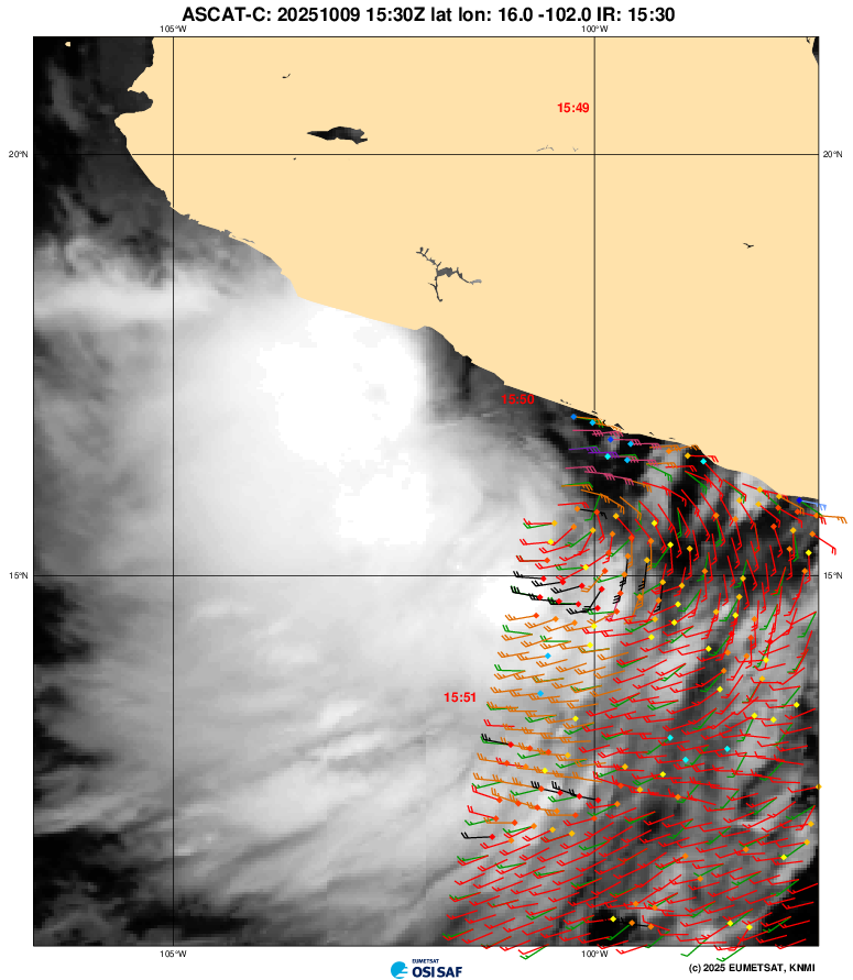
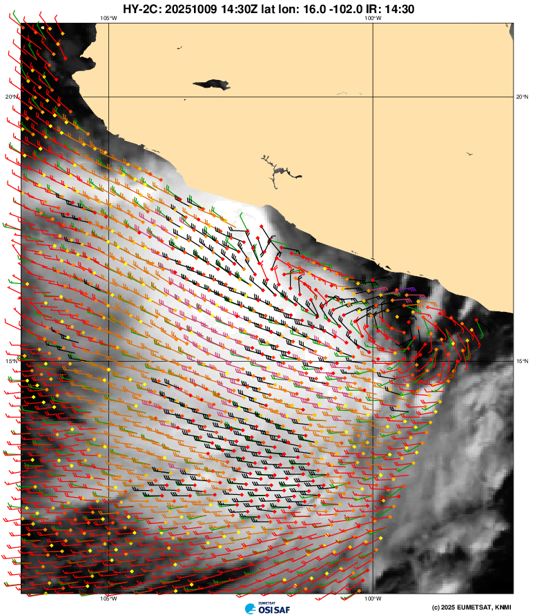
Got a partial ASCAT and an earlier HY-2C pass with some not-rainflagged gale-force vectors...
Edit: With the 18Z intermediate advisory (oops) TS Raymond forms..
WTPZ32 KNHC 091749
TCPEP2

BULLETIN
Tropical Storm Raymond Intermediate Advisory Number 1A
NWS National Hurricane Center Miami FL       EP172025
1200 PM CST Thu Oct 09 2025

...RAYMOND FORMS OFF THE COAST OF SOUTHWESTERN MEXICO...


SUMMARY OF 1200 PM CST...1800 UTC...INFORMATION
-----------------------------------------------
LOCATION...16.1N 101.0W
ABOUT 115 MI...190 KM SSE OF ZIHUATANEJO MEXICO
ABOUT 745 MI...1200 KM SE OF THE SOUTHERN TIP OF BAJA CALIFORNIA
MAXIMUM SUSTAINED WINDS...45 MPH...75 KM/H
PRESENT MOVEMENT...WNW OR 285 DEGREES AT 14 MPH...22 KM/H
MINIMUM CENTRAL PRESSURE...1002 MB...29.59 INCHES


WATCHES AND WARNINGS
--------------------
CHANGES WITH THIS ADVISORY:

The government of Mexico has issued a Tropical Storm Watch from
Zihuatanejo to Cabo Corrientes, Mexico.

SUMMARY OF WATCHES AND WARNINGS IN EFFECT:

A Tropical Storm Watch is in effect for...
* Zihuatanejo to Cabo Corrientes, Mexico

A Tropical Storm Watch means that tropical storm conditions are
possible within the watch area, in this case within the next 36
hours.

Interests in southern Baja California Sur should monitor the
progress of this system.

For storm information specific to your area, please monitor
products issued by your national meteorological service.


DISCUSSION AND OUTLOOK
----------------------
At 1200 PM CST (1800 UTC), the center of Tropical Storm Raymond was
located near latitude 16.1 North, longitude 101.0 West. Raymond is
moving toward the west-northwest near 14 mph (22 km/h) and this
general motion is expected to continue through early Friday.  A turn
toward the northwest is expected by late Friday, followed by a
northward turn by early Sunday.  On the forecast track, the center
of the storm is expected to move parallel to the southwestern
coast of Mexico through Friday and then be near southern Baja
California Sur Saturday and Sunday.

Maximum sustained winds have increased to near 45 mph (75 km/h)
based on satellite derived winds with higher gusts. Some
strengthening is forecast through Friday, but weakening is likely
over the weekend.

Tropical-storm-force winds extend outward up to 50 miles (95 km)
from the center.

The estimated minimum central pressure is 1002 mb (29.59 inches).


HAZARDS AFFECTING LAND
----------------------
WIND:  Tropical storm conditions are possible within the eastern
part of the watch area later today and could spread westward across
the remainder of the area through late Friday.

RAINFALL: Outer bands from the tropical storm will bring heavy
rain to portions of southwestern Mexico through Saturday.  Across
coastal portions of Oaxaca, Guerrero, Michoacán, Colima, and
Jalisco, rainfall amounts of 2 to 4 inches are expected, with local
amounts of 6 inches or more in Guerrero and Michoacán. This rainfall
will bring a risk of flash flooding, especially in areas of higher
terrain.  Moisture from the tropical storm will bring the
potential for additional heavy rainfall over portions of the
Southwest U.S. early next week.

For a complete depiction of forecast rainfall and flash flooding
associated with the storm, please see the National Weather
Service Storm Total Rainfall Graphic, available at
hurricanes.gov/graphics_ep2.shtml?rainqpf

SURF:  Swells generated by the storm are expected to spread
westward along the southwestern coast of Mexico through Friday and
reach southern Baja California Sur on Saturday.  Please consult
products from your local weather office.


NEXT ADVISORY
-------------
Next complete advisory at 300 PM CST.

$$
Forecaster Kelly
~
Got a partial ASCAT and an earlier HY-2C pass with some not-rainflagged gale-force vectors...
Last tcvitals from 06Z was at 25kt. 12Z tcvitals should come out any time now....
~
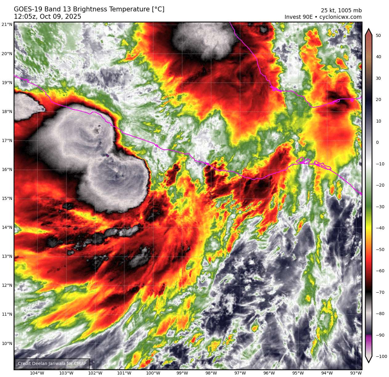
Looking healthier today on shortwave IR
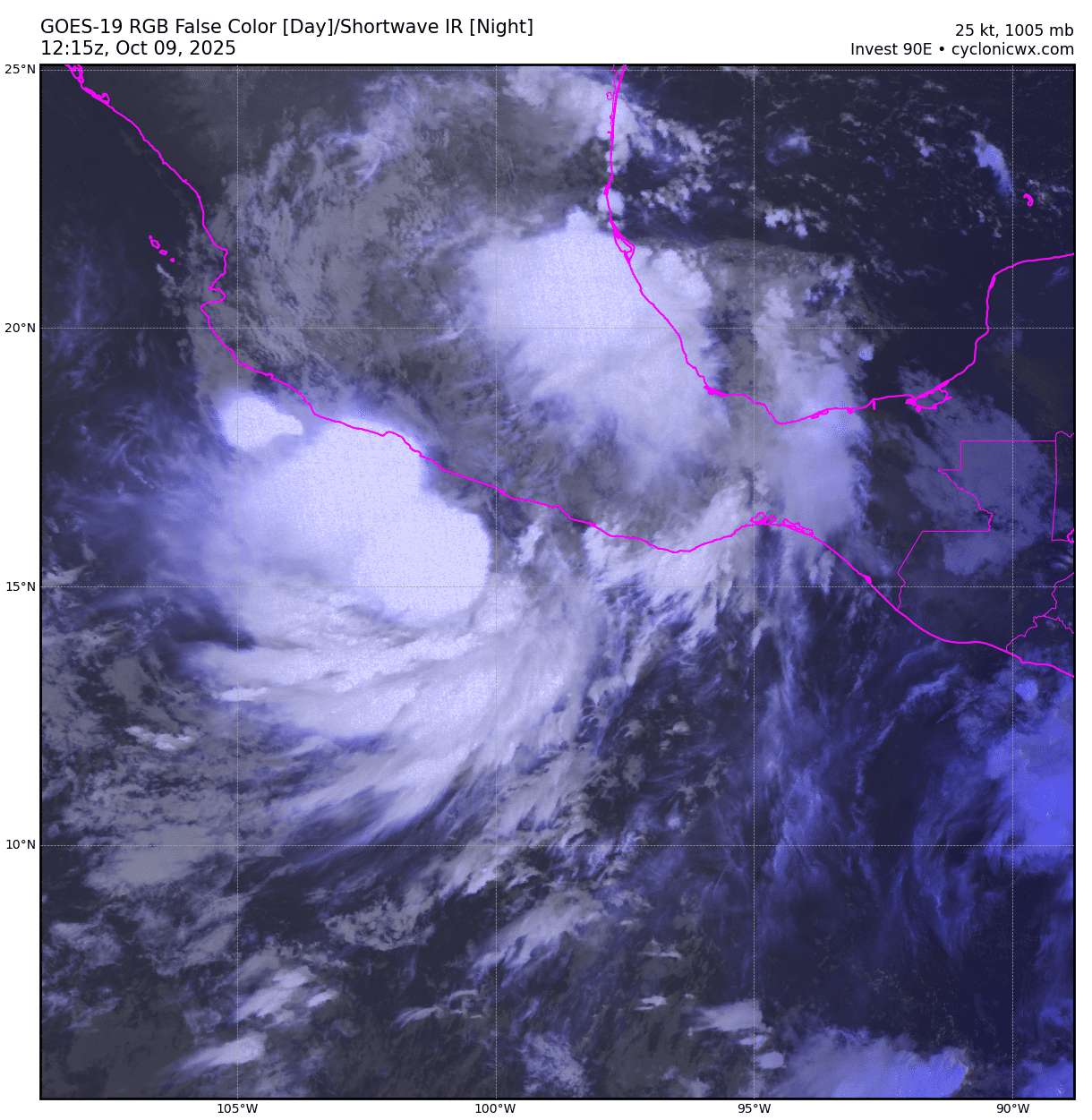
A -90C burst on recent IR:
Most recent scatterometer from earlier at 07Z shows a possible slightly elongated surface circulation close to the coast (plenty of rain-flagged gale-force wind vectors):
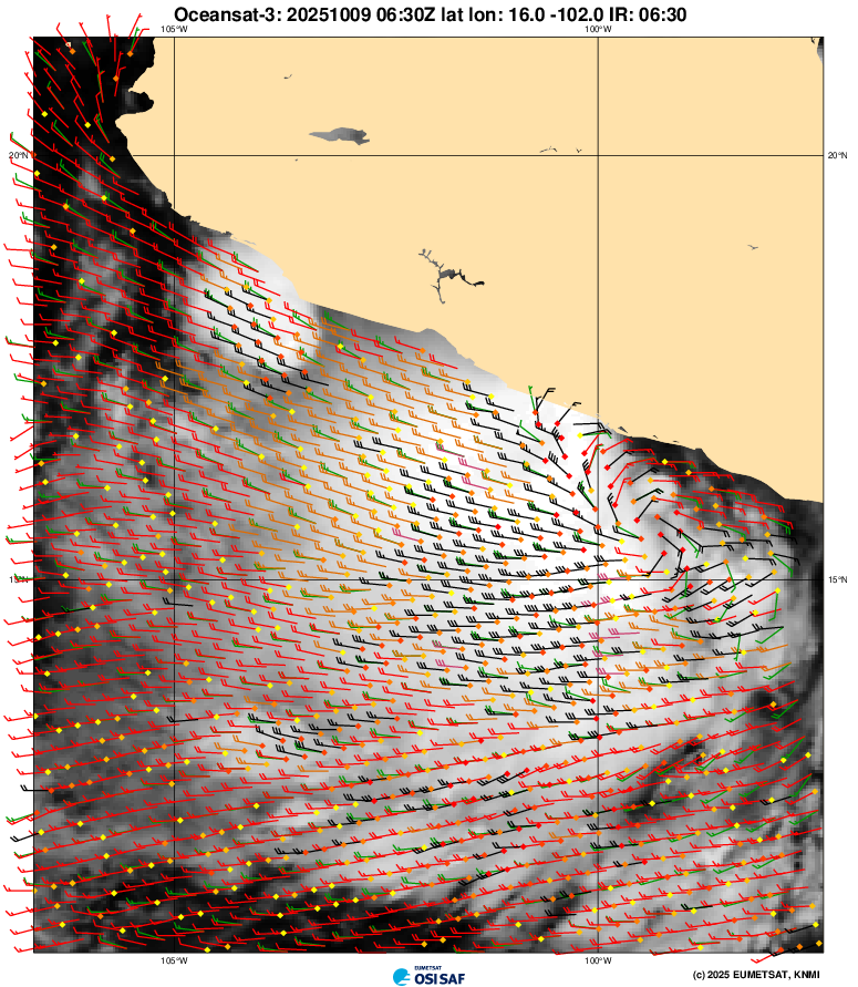
Other satellite estimates over last 6 hours, CIMSS D-PRINT from 33-41 kt, and MTCSWA 28-33 kt.
Somewhat dated DVTS from SAB at 06Z is only 1.0/1.0.
Looks a bit disorganized from the various CIMSS vorticity levels given the unfavorable vertical shear.
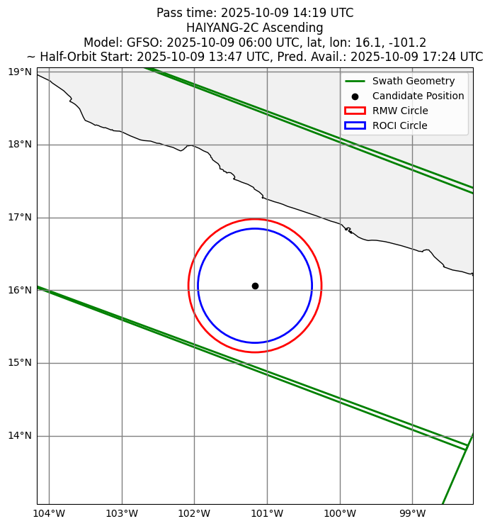
Should be a solid HY-2C pass later (if it's not late) available before the 21Z advisory (perhaps around ~17:30Z)
Posting the full discussion now that we have TD17
WTPZ42 KNHC 091440
TCDEP2
Tropical Depression Seventeen-E Discussion Number 1
NWS National Hurricane Center Miami FL EP172025
900 AM CST Thu Oct 09 2025
The large area of disturbed weather located near the southwestern
coast of Mexico (Invest 90E) has continued to gain organization.
Convective banding has become more evident in the southern and
western part of the circulation, and the latest Dvorak estimates
from TAFB and SAB are T2.0 and T1.5, respectively. The convective
pattern does suggest that the circulation might still be a bit
elongated, but hourly observations from a cruise ship, the
Norwegian Joy (C6CX3), helped to locate the main center of
circulation, pressure minimum, and estimated winds. The
circulation and convection are now organized enough to classify the
system as a tropical depression.
The center we're now tracking is somewhat discontinuous from a
feature we were tracking yesterday farther to the east, and the
initial motion is a rough estimate of west-northwestward, or 285/12
kt. Strong mid-level ridging over northern Mexico and the
south-central U.S. is expected to steer the depression on a quick
west-northwestward to northwestward track during the next 48 hours,
with the center paralleling the southwestern coast of Mexico through
late Friday. The system is then likely to round the western
periphery of the high and move toward the Baja California peninsula
in 2-3 days. The model guidance is in fairly good agreement for
this first forecast, and the NHC track is close to a blend of the
TVCE and HCCA consensus aids.
The depression is being affected by strong easterly shear which is
likely to continue for the next 24 hours. However, the system is
also over very warm waters (29-30 degrees Celsius), in an
environment of strong upper-level divergence, and moving
quickly, which should all allow for some modest strengthening
during that time. The NHC forecast is near the top end of
the guidance and close to the HCCA aid in the short term. Although
the shear is forecast to decrease some after 24 hours, the
mid-level environment is expected to become drier and more stable
while the upper-level winds become more convergent. Those changes
should induce weakening while the system is approaching the southern
Baja California peninsula. Although a remnant low point is
provided over northwestern Mexico on day 4, it is likely that the
system will dissipate before that time.
KEY MESSAGES:
1. Tropical storm conditions are possible along portions of the
coast of southwestern Mexico through late Friday. Interests in
southern Baja California Sur should monitor the progress of the
system.
2. Heavy rainfall associated with the tropical depression will
impact coastal sections of southwestern Mexico through Saturday,
which could result in flash flooding, particularly in areas of
higher terrain.
FORECAST POSITIONS AND MAX WINDS
INIT  09/1500Z 16.2N 100.8W   30 KT  35 MPH
 12H  10/0000Z 16.8N 102.6W   40 KT  45 MPH
 24H  10/1200Z 18.1N 105.1W   45 KT  50 MPH
36H 11/0000Z 19.8N 107.8W 40 KT 45 MPH
48H 11/1200Z 21.4N 109.9W 35 KT 40 MPH
60H 12/0000Z 23.3N 111.0W 30 KT 35 MPH
72H 12/1200Z 25.5N 111.2W 30 KT 35 MPH
96H 13/1200Z 29.2N 110.7W 15 KT 15 MPH...POST-TROP/REMNT LOW
120H 14/1200Z...DISSIPATED
$$
Forecaster Berg