When will Tropical Storm Genevieve form? (EP)
0
Ṁ1kresolved Jul 24
100%20%
July 24
20%
July 23
20%
July 25
20%
July 26
20%Other
Resolution source: https://www.nhc.noaa.gov/archive/2026/
Subtropical storm also counts.
Resolves to the UTC time written in the advisory text.
N/A if does not form in 2026.
Will add days to the answers as needed.
This question is managed and resolved by Manifold.
Market context
Get  1,000 to start trading!
1,000Sort by:
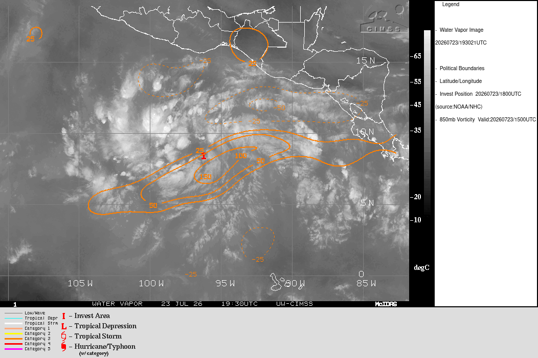
Now a TD, expected to become a TS today/tomorrow from the forecast, and forecast to become a major hurricane.
WTPZ42 KNHC 241437
TCDEP2

Tropical Depression Seven-E Discussion Number   1
NWS National Hurricane Center Miami FL       EP072026
900 AM CST Fri Jul 24 2026

Showers and thunderstorms have become better organized with the area
of low pressure that the NHC has been monitoring well offshore of
southern Mexico. In addition, 0807 UTC AMSR-2 passive microwave
images indicate the system has a closed low-level circulation with
good definition. The current satellite presentation suggests it
could be dealing with some northeasterly shear, with deep convection
mostly west and southwest of the estimated center position. Since
this system meets tropical cyclone criteria, we are initiating
advisories on Tropical Depression Seven-E with an initial intensity
of 30 kt based on a T2.0 Dvorak classification from TAFB. Some
scatterometer data expected later today should help refine the
center position and intensity estimates.

The estimated initial motion is west-northwestward (285/10 kt), but
this is somewhat uncertain since the depression just formed. The
system should maintain a west-northwestward or northwestward heading
during the next several days with a ridge entrenched to its north
and northeast. Overall, the track model guidance is tightly
clustered with limited cross-track spread. There are more
differences in the along-track direction, with the Google Deep Mind
ensemble mean significantly faster than the rest of the models. The
first NHC track forecast uses a consensus approach and generally
falls between the simple (IVCN) and corrected (HCCA) consensus aids.

Generally weak deep-layer vertical wind shear, very warm SSTs around
30C, and a strongly divergent upper-level environment are likely to
support steady to rapid intensification (RI) during the next few
days. The bulk of the intensity guidance is very aggressive with
strengthening, particularly in the 24-72 h window when the shear
falls below 10 kt. The DTOPS shows a 76 percent chance of a 65-kt
increase in 72 h, and more than 60 percent of the Google Deep Mind
ensemble members show the system becoming a major hurricane. The
NHC intensity forecast explicitly shows RI between 36-72 h and has
it reaching major hurricane status early next week, in agreement
with the simple consensus (IVCN) and slightly below the HCCA aid.


FORECAST POSITIONS AND MAX WINDS

INIT  24/1500Z  9.0N 100.5W   30 KT  35 MPH
 12H  25/0000Z  9.3N 101.7W   40 KT  45 MPH
 24H  25/1200Z 10.5N 103.7W   45 KT  50 MPH
 36H  26/0000Z 11.7N 106.2W   55 KT  65 MPH
 48H  26/1200Z 12.9N 108.5W   70 KT  80 MPH
 60H  27/0000Z 14.0N 110.5W   85 KT 100 MPH
 72H  27/1200Z 15.3N 112.3W  100 KT 115 MPH
 96H  28/1200Z 17.2N 115.0W  100 KT 115 MPH
120H  29/1200Z 19.0N 118.0W   90 KT 105 MPH

$$
Forecaster Reinhart
TS Genevieve formed with the July 24/21Z advisory:
WTPZ42 KNHC 242037
TCDEP2

Tropical Storm Genevieve Discussion Number   2
NWS National Hurricane Center Miami FL       EP072026
300 PM CST Fri Jul 24 2026

GOES-18 RGB composite imagery and a 1606 UTC METOP-B scatterometer
overpass indicate that the cloud pattern has become better
organized and the surface circulation is better defined.  Deep
convective coverage continues to expand, and a developing curved
band wraps halfway around the center.  The ASCAT data (which showed
35-38 kt believable surface vector winds) and the TAFB Dvorak
satellite intensity estimate of T2.5 support 35-40 kt. However,
Dvorak rules prevent a reasonable T3.0 (45 kt) classification. Based
on these data, the depression has been upgraded to a 40-kt Tropical
Storm Genevieve.

The global model forecast soundings indicate modest
west-northwesterly shear is undercutting the lighter diffluent flow
above 250 mb, and appears to be impinging on the northeast quadrant
of the convective mass.  The SHIPS and the global model fields
suggest, however, that the shear will diminish during the next 12
hours.  The latest NOAA AOML ocean analysis indicates that
Genevieve will be traversing a region of very high tropical cyclone
ocean heat potential within the next 36 hrs or so.  As a result,
various rapid intensification techniques and the Google DeepMind
(GDM) ensemble continue to predict a high probability that
Genevieve will undergo a period of rapid intensification (RI) by
mid-period.  Accordingly, the official intensity forecast continues
to reflect RI between 24 and 48 hours and Genevieve becoming a major
hurricane early next week, using a blend of the HFIP HCCA corrected
consensus and the GDM.

Genevieve's initial motion is estimated to be west-northwestward,
or 290/11 kt while being steered by mid-tropospheric high pressure
anchored over northwestern Mexico. The bulk of the models remain in
good agreement with a continued west-northwest heading through the
period, and the NHC forecast follows suit, while lying closely to
the HCCA consensus and the GDM ensemble mean.


FORECAST POSITIONS AND MAX WINDS

INIT  24/2100Z  9.2N 101.9W   40 KT  45 MPH
 12H  25/0600Z  9.9N 103.4W   45 KT  50 MPH
 24H  25/1800Z 11.2N 105.7W   55 KT  65 MPH
 36H  26/0600Z 12.4N 108.1W   75 KT  85 MPH
 48H  26/1800Z 13.5N 110.4W   90 KT 105 MPH
 60H  27/0600Z 14.8N 112.3W  100 KT 115 MPH
 72H  27/1800Z 16.1N 113.9W  110 KT 125 MPH
 96H  28/1800Z 17.9N 116.7W  110 KT 125 MPH
120H  29/1800Z 19.4N 119.5W   95 KT 110 MPH

$$
Forecaster Roberts