Will a Very Severe Cyclonic Storm be reported in the North Indian Ocean in the next two weeks?
Resolution criteria:
If RSMC New Delhi reports a Very Severe Cyclonic Storm (or higher intensity) in the North Indian Ocean before December 11 00Z, 2023 (and after November 27 00Z, 2023) this question resolves YES immediately. Otherwise, it will resolve NO after closing.
Note: VSSC is >=64kt (3 minute average).
Note: the two weeks in the question title is approximate.
Note: I mention the cyclone genesis forecast in the Bay of Bengal, but if it happens in the Arabian Sea (or anywhere in the North Indian Ocean), it will resolve YES.
If I can find no such report on RMSC New Delhi's website before before December 12 00Z this resolves NO (this question covers from November 27 00Z, 2023 up until just before December 11 00Z, 2023).
Resolution time:
Will resolve immediately only if YES criteria is met, otherwise, will resolve soon after question closing time.
References & Motivation:
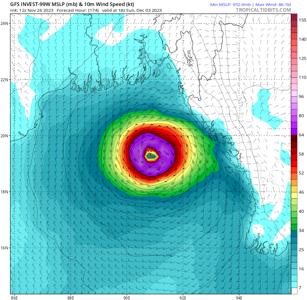
RSMC outlook is forecasting a TC with high likelihood in the Bay of Bengal:
"A CYCLONIC CIRCULATION LAY OVER SOUTH THAILAND AND ADJOINING SOUTH ANDAMAN SEA IN THE EARLY MORNING (0000 UTC) OF TODAY, THE 26TH NOVEMBER, 2023. IT LAY OVER SOUTH ANDAMAN SEA AND ADJOINING SOUTH THAILAND AT 0300 UTC EXTENDING UPTO 5.8 KM ABOVE MEAN SEA LEVEL. UNDER ITS INFLUENCE, A LOW-PRESSURE AREA IS LIKELY TO FORM OVER SOUTH ANDAMAN SEA & ADJOINING SOUTHEAST BAY OF BENGAL AROUND 27TH NOVEMBER. IT IS LIKELY TO MOVE WEST-NORTHWESTWARDS AND INTENSIFY INTO A DEPRESSION OVER SOUTH-EAST BAY OF BENGAL AROUND 29TH NOVEMBER 2023."
Extended outlook with more reasoning:
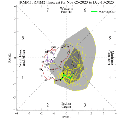
NCEP MJO forecast (GEFSBC) https://www.cpc.ncep.noaa.gov/products/precip/CWlink/MJO/foregfs.shtml:
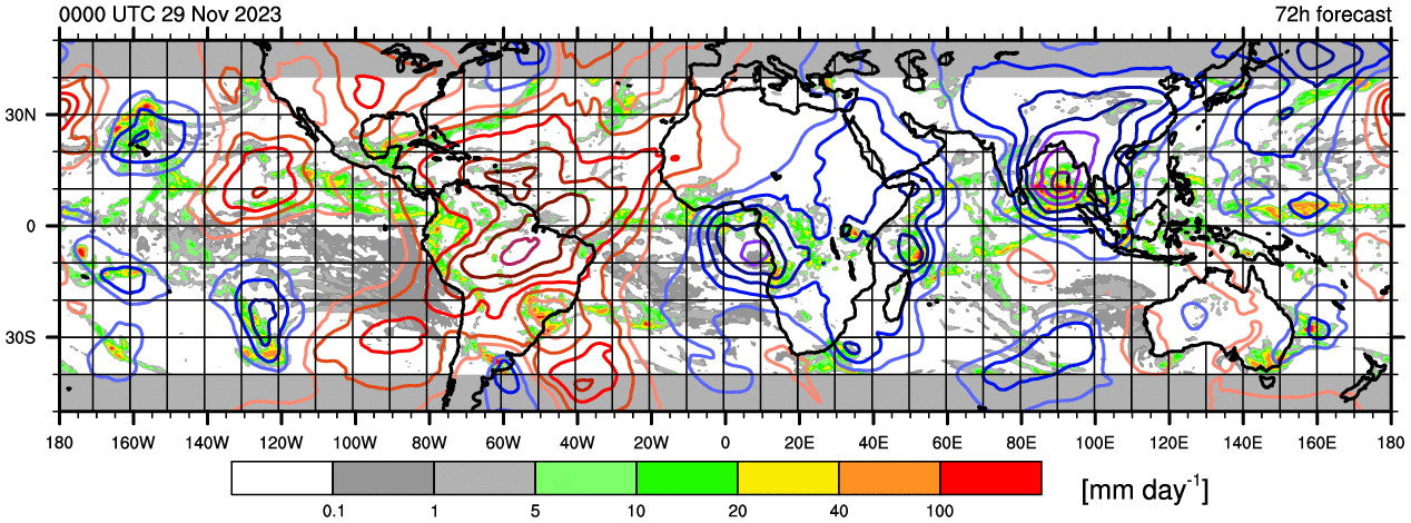
200 hPa velocity potential, GFS forecast (https://www.atmos.albany.edu/student/ventrice/real_time/maps/velocity_pot/anom/global_forecast.html):
 1,000
1,000🏅 Top traders
| # | Trader | Total profit |
|---|---|---|
| 1 | Ṁ95 | |
| 2 | Ṁ37 | |
| 3 | Ṁ18 | |
| 4 | Ṁ2 | |
| 5 | Ṁ0 |
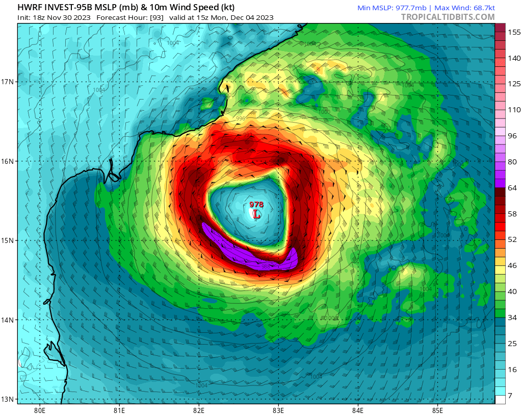
Betting mostly just to keep track. Conditions right now look broadly favorable for development by next weekend. Too far out to know anything for sure - but the 12z GFS run was rather funky today, though it seems to havea backtracked a lot with the 18z.