Resolves UTC, subtropical storms also count for the purpose of this market
For a tropical storm to be named Gabrielle, a different tropical storm must be named Fernand first
 1,000
1,000🏅 Top traders
| # | Trader | Total profit |
|---|---|---|
| 1 | Ṁ229 | |
| 2 | Ṁ146 | |
| 3 | Ṁ137 | |
| 4 | Ṁ21 | |
| 5 | Ṁ19 |
https://manifold.markets/SaviorofPlant/what-will-be-the-maximum-intensity-ItPNltQPZp?r=U2F2aW9yb2ZQbGFudA
I have created an intensity market for this storm.
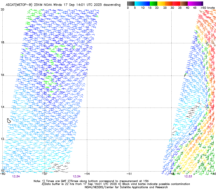
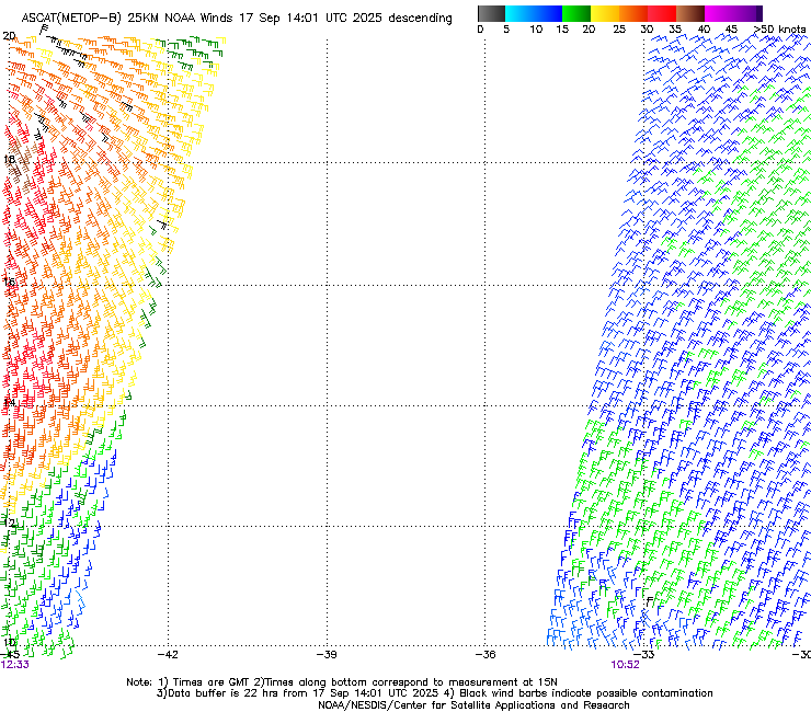
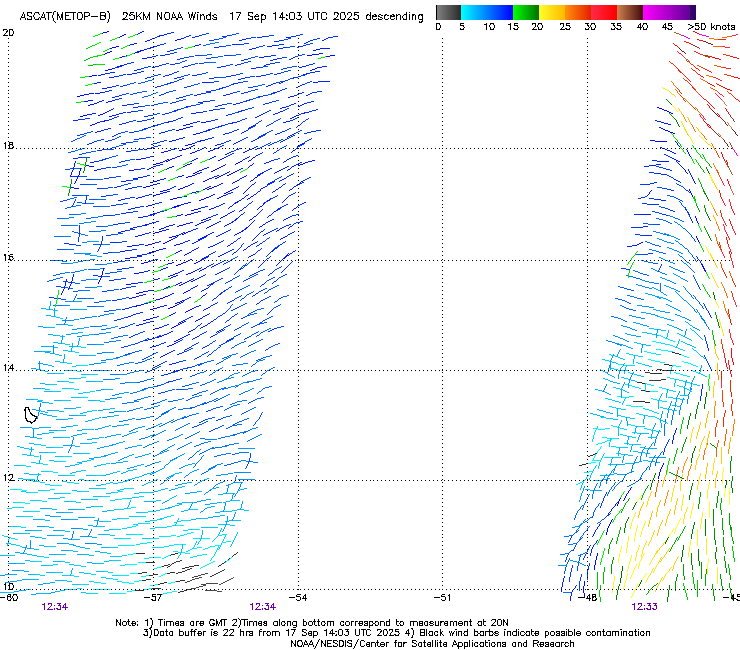
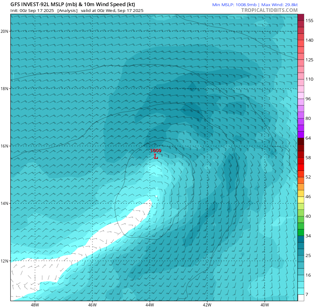
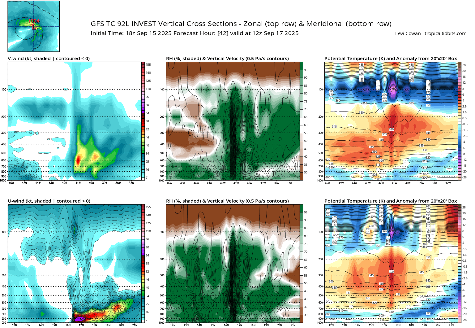
The 12:33Z Metop-B pass was a hit over the center with enough gale force wind vectors...
They are going to name it for the 15Z advisory.
It's ambiguous to me from the ascat data alone though whether there actually is still a closed center or whether it is trough like ...
The vis imagery around then and after continue to show the exposed LLCC though... (even if its not completely closed from the surface center given the lack of convection now, the strong vorticity from the rest of the lower levels would fill in the rest of the circulation)
Special Message from NHCWed, 17 Sep 2025 08:06:57 +0000
NHC will initiate advisories on Tropical Depression Seven, located over the central tropical Atlantic, at 500 AM EDT (0900 UTC).
~
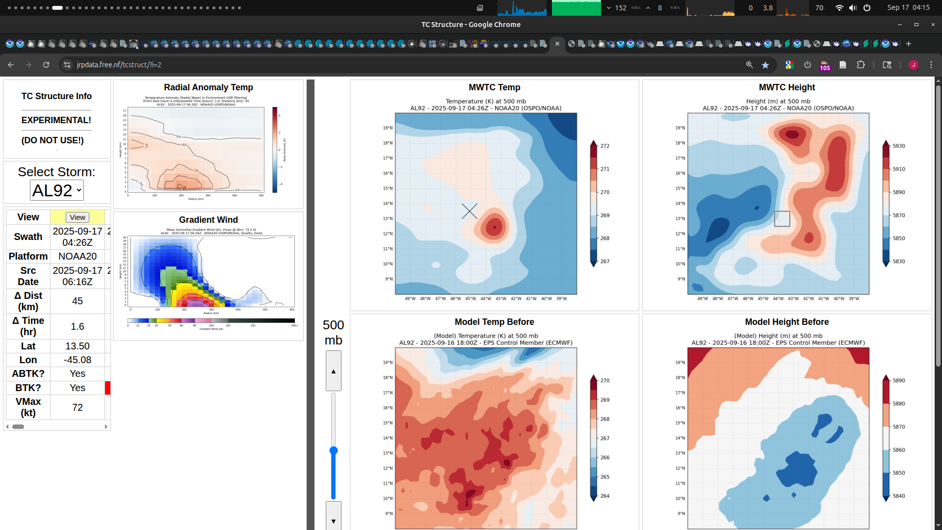
A 0426Z, NOAA20 sounding (towards the period of sustained heavy convection mentioned below ), shows less ventilation at 500mb than previously (but not any apparent deepening in the height data provided)
I don't know what they saw to establish the closed surface circulation...
TD7 has formed, NHC forecasting a TS before the day is over...
000
WTNT42 KNHC 170835
TCDAT2

Tropical Depression Seven Discussion Number   1
NWS National Hurricane Center Miami FL       AL072025
500 AM AST Wed Sep 17 2025

Satellite data indicate that Invest 92L over the central tropical
Atlantic has now developed into a tropical depression.  ASCAT data
from around 00Z showed that the circulation of the system had
improved, and although it was not well defined at the time of the
pass, the system was only lacking some northerly winds on its west
side.  Since deep convection has been persisting and consolidating
near the center, it appears to now meet the convective and
circulation criteria needed to be considered a tropical cyclone.
However, it should be noted that the system is quite large and there
is still considerable north-south elongation in the low-level
structure. The initial intensity is set at 30 kt based on a blend of
the ASCAT data and the latest Dvorak estimate from TAFB.  The
development of this system breaks a nearly 3-week streak of no
tropical cyclones in the Atlantic basin during the peak of the
hurricane season.

The depression is well away from land and roughly midway between the
Cabo Verde Islands and the Windward Islands.  The system is
estimated to be moving westward at 11 kt, but this is of low
confidence since the center has only recently formed.  A turn to the
northwest, perhaps influenced by a center formation, is expected to
occur soon as the depression moves toward a weakness in the Atlantic
subtropical ridge caused by a mid- to upper-level low to its north.
The models show this low weakening in a day or two, which will
likely cause the cyclone to turn back to the west-northwest late
this week.  However, the system should reach the western periphery
of the ridge this weekend, resulting in a turn to the northwest or
north.  The NHC track forecast is a little to the right of the
consensus aids, giving more weight to the ECMWF and Google Deep Mind
predictions, which are faster and on the right side of the guidance.
Based on the steering pattern, and deterministic and ensemble model
solutions, there is high confidence that this system should pass
well east of the Windward and Leeward Islands.  Interests in Bermuda
should monitor forecasts of the depression over the next several
days.

Only modest strengthening is expected over the next day or two as
the depression continues to battle moderate shear from the
aforementioned low aloft and intrusions of dry air.  However, more
notable strengthening seems likely by the weekend when the system
moves into more conducive environmental conditions.  The NHC
intensity forecast shows the system reaching hurricane strength
toward the end of the period, but it should be noted that the spread
in the models at that time is significant and ranges from solutions
showing a weak low to a major hurricane.  This prediction is
generally in line with the IVCN aid.


FORECAST POSITIONS AND MAX WINDS

INIT  17/0900Z 13.7N  45.9W   30 KT  35 MPH
 12H  17/1800Z 15.8N  47.4W   35 KT  40 MPH
 24H  18/0600Z 17.6N  49.6W   40 KT  45 MPH
 36H  18/1800Z 19.0N  51.9W   40 KT  45 MPH
 48H  19/0600Z 19.7N  54.0W   45 KT  50 MPH
 60H  19/1800Z 20.4N  55.9W   50 KT  60 MPH
 72H  20/0600Z 21.6N  57.6W   55 KT  65 MPH
 96H  21/0600Z 24.0N  60.0W   65 KT  75 MPH
120H  22/0600Z 26.9N  63.0W   75 KT  85 MPH

$$
Forecaster Cangialosi
~
Going to need a clean scatterometer pass showing no closed surface circulation for this not to happen given they've already classified it as a TD, as based on the last few days of looking at models the trend is for 10 kt of strengthening over the entire day, and given we have half a day left 5 kt of strengthening seems about right... (given the scatterometer data I've seen 35 kt actually seems like it is too conservative from the blending of the subjective data, and 40 kt actually seems like a more realistic target if they don't blend...)
Some service notes for ascat scatterometer data today that may affect passes over 92L..
1) Metop-C has been data has been unavailable since last night due to an instrument anomaly.
Edit: oops I was a bit sleepy and that Metop-B pass was for tomorrow
The last pair of ASCAT passes from earlier failed to show a clearly defined circulation. With less convection and moisture lately in satellite imagery, it now looks unlikely to be declared a TS in the next 4 hours.
@SaviorofPlant ?? What do you see that you like for development today?
This doesn't look good for today...
@parhizj It's not me lol, random traders bet up September 16. This market has been open so long that it has way more activity than a normal TS formation market
Yesterday I was thinking the system off North Carolina had a small chance to become a subtropical storm but I only put 7 mana in and that didn't materialize
@SaviorofPlant Yeah those are always wildcards that don't show up in the outlook until the NHC has a much higher confidence it will break away from the front.
The real problem for me is for a < 1 day length storm it won't show up in my tracker as that would just completely filtered other short lived storms the day of (needs 24 hours of points).
Edit: Vorticity analysis shows much higher spin and GEFS/12Z has 100% of its members reaching TS strength by tomorrow.
I've bet up Other against the current objective guidance:
But subjectively given my little experience: the amount of twisting it seems to be experiencing between the different levels, and the lack of deep convection and lightning with high deep wind shear, I won't be surprised if this degenerates for the short term and possibly not develop at all...
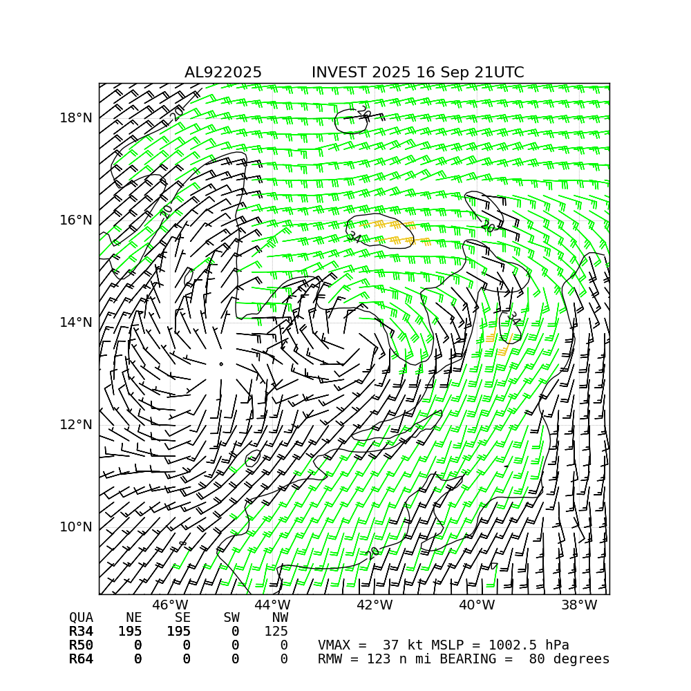
Pass predictions for select satellites for the 17th (until 21Z) based on mean of google 18Z ensemble:
ASCAT-B has just been acquired so products should be coming in next 10-15 mins...
Closeup of Expected swaths:
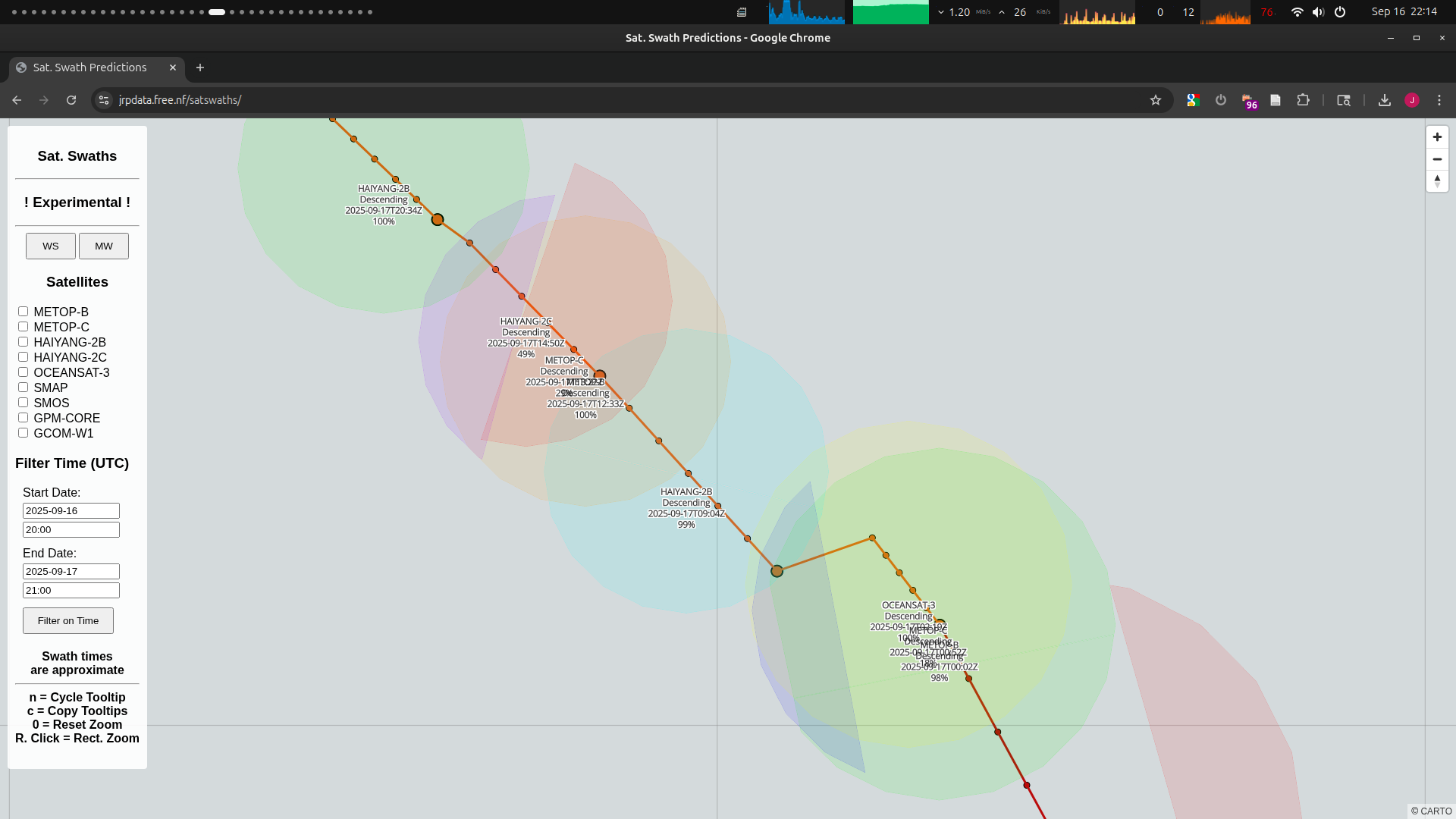
Pass Predictions for Microwave:
SMAP
Descending
2025-09-16T20:26Z
78%
SMOS
Descending
2025-09-16T21:25Z
23%
GCOM-W1
Descending
2025-09-17T16:21Z
100%
~~
Pass Predictions for Scatterometer:
HAIYANG-2B
Descending
2025-09-16T20:10Z
20%
METOP-B
Descending
2025-09-17T00:02Z
98%
METOP-C
Descending
2025-09-17T00:52Z
18%
OCEANSAT-3
Descending
2025-09-17T02:19Z
100%
HAIYANG-2B
Descending
2025-09-17T09:04Z
99%
METOP-B
Descending
2025-09-17T12:33Z
100%
METOP-C
Descending
2025-09-17T13:22Z
29%
HAIYANG-2C
Descending
2025-09-17T14:50Z
49%
HAIYANG-2B
Descending
2025-09-17T20:34Z
100%
Latest TWO kept at 90%/90%.
ABNT20 KNHC 170506
TWOAT

Tropical Weather Outlook
NWS National Hurricane Center Miami FL
200 AM EDT Wed Sep 17 2025

For the North Atlantic...Caribbean Sea and the Gulf of America:

Central Tropical Atlantic (AL92):
Satellite wind data indicate that the low pressure system located
about midway between the Windward Islands and the Cabo Verde Islands
is gradually becoming better defined.  In addition, the associated
shower and thunderstorm activity has become a little more
concentrated during the past several hours.  If these trends
continue, advisories could be initiated on a tropical depression
later today.  The system is expected to move generally northwestward
at 10 to 15 mph over the central tropical and subtropical Atlantic
during the next several days.  Additional information on this
system, including gale warnings, can be found in High Seas Forecasts
issued by the National Weather Service.
* Formation chance through 48 hours...high...90 percent.
* Formation chance through 7 days...high...90 percent.

Eastern Tropical Atlantic:
A tropical wave located a couple of hundred miles east-southeast of
the Cabo Verde Islands is producing an area of disorganized showers
and thunderstorms.  Environmental conditions are only marginally
conducive, and any development of this system should be slow to
occur while it moves westward at 15 to 20 mph across the eastern and
central portion of the tropical Atlantic.  Regardless of
development, this system will likely bring areas of heavy rain
across the Cabo Verde Islands later today and Thursday.
* Formation chance through 48 hours...low...10 percent.
* Formation chance through 7 days...low...20 percent.

&&

High Seas Forecasts issued by the National Weather Service
can be found under AWIPS header NFDHSFAT1, WMO header FZNT01
KWBC, and online at ocean.weather.gov/shtml/NFDHSFAT1.php

$$
Forecaster Cangialosi
~
Given the above comments, and some other possible hints that they expect to classify it, I am not willing to discount it too heavily it will still be classified a TS today given. But I think based on the below and previous analysis I did over the last couple days there is a decent chance 92L doesn't get named today, so I will continue to hedge more in that direction ..
~ very long thread
Subjectively given the 06Z downgrade below for now, I don't think we will get a 09Z advisory naming it.... but its only ~ an hour away (especially since its still considered a low in the best track and the oceansat pass was a partial so we dont have evidence of a well defined LLCC).
I have not spent any time looking at the relatively fresh AEW as it seems less urgent than 92L from the ensembles.
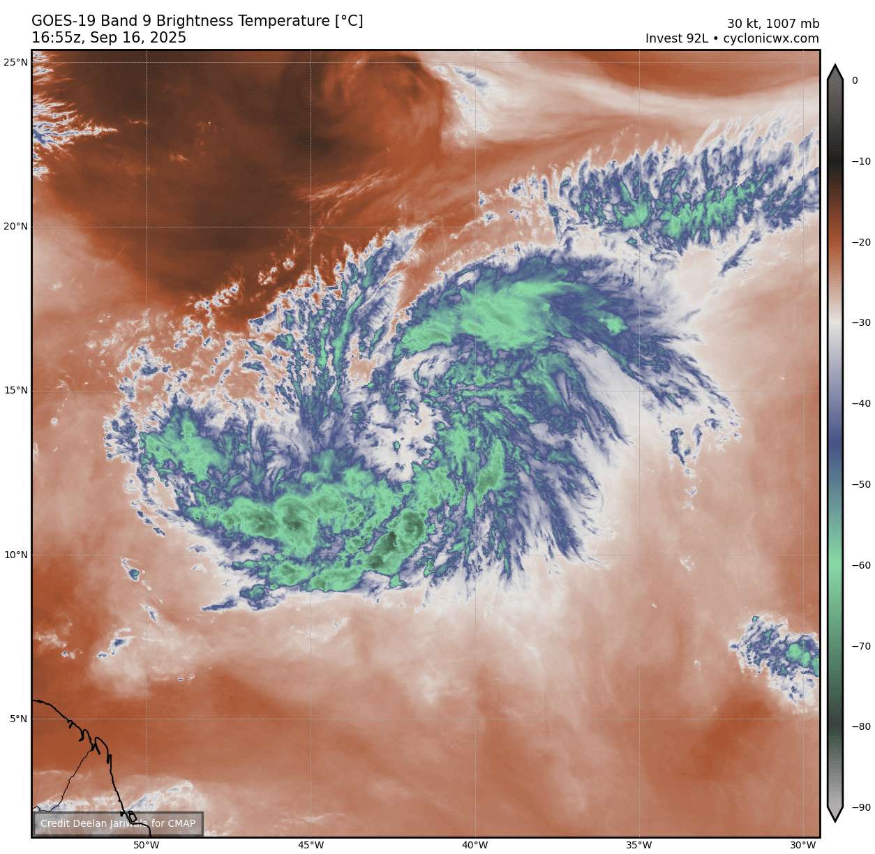
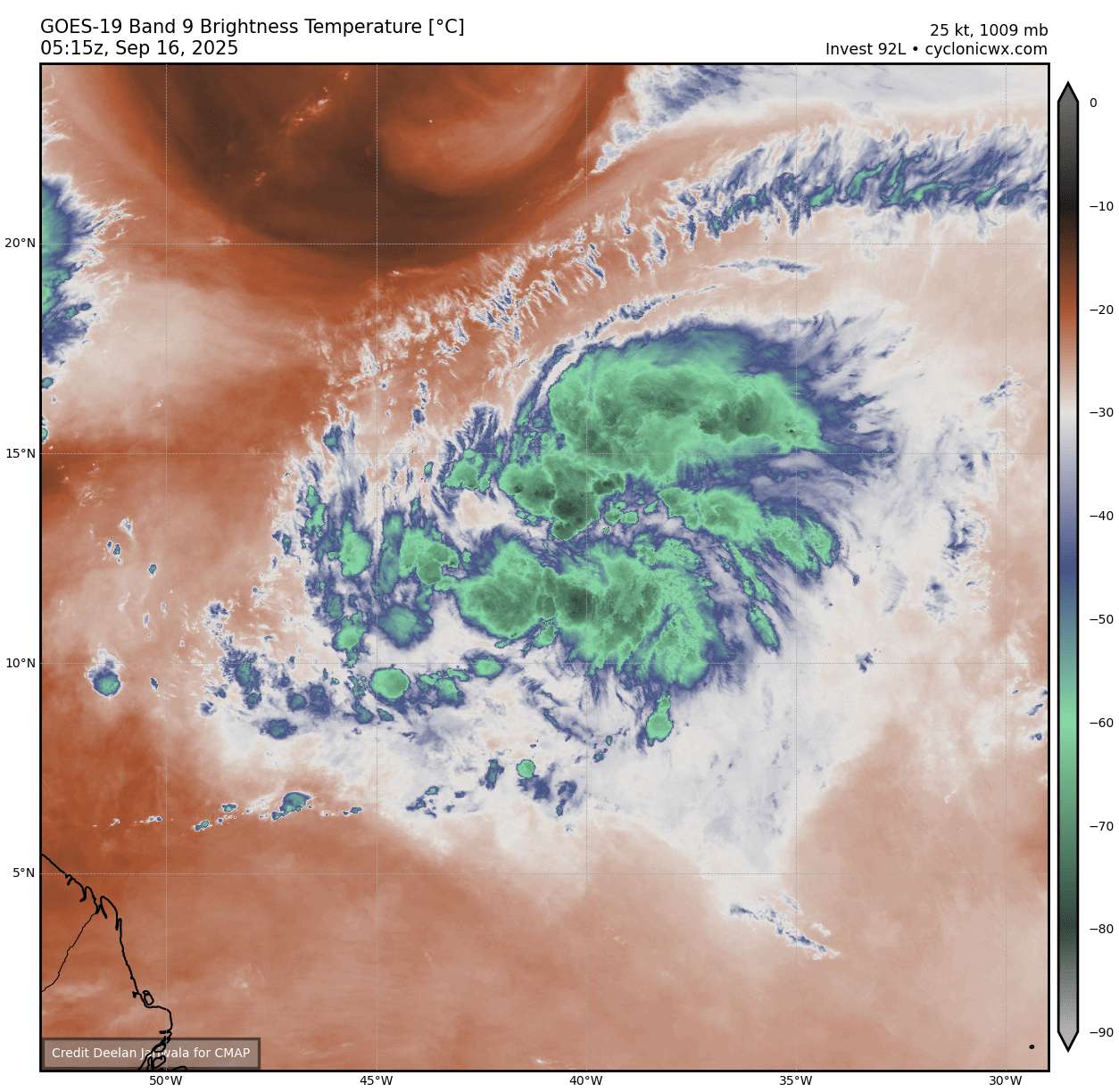
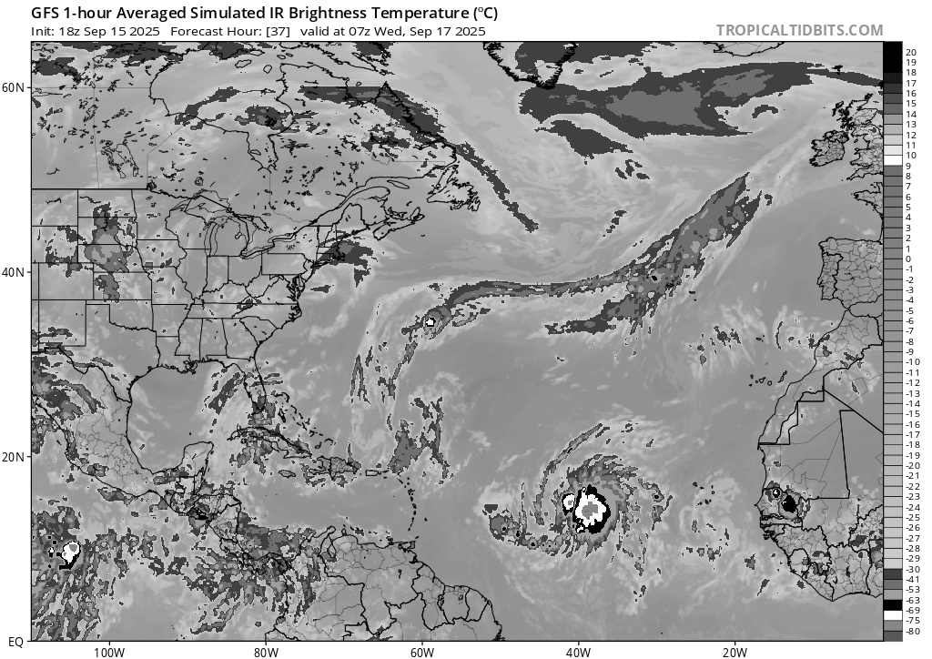
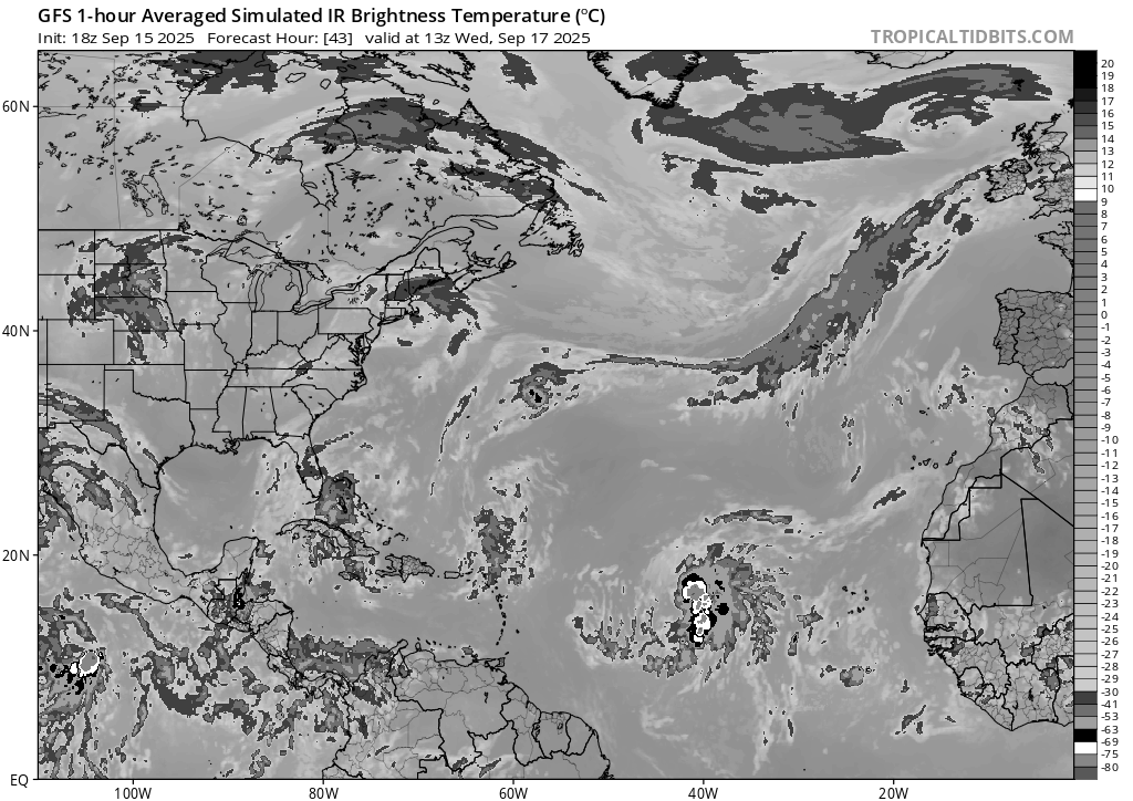
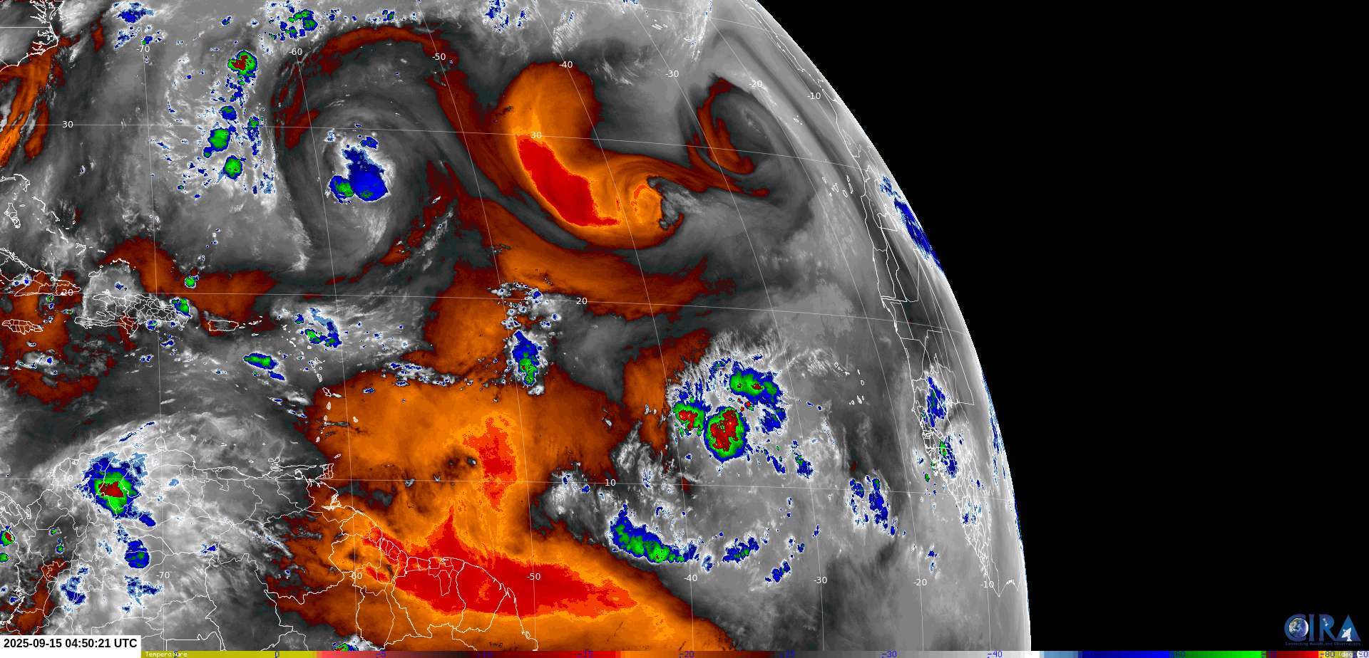
Recent WV from cyclonicwx:
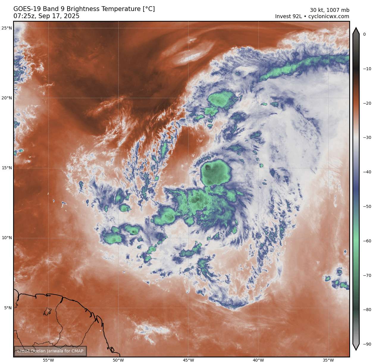
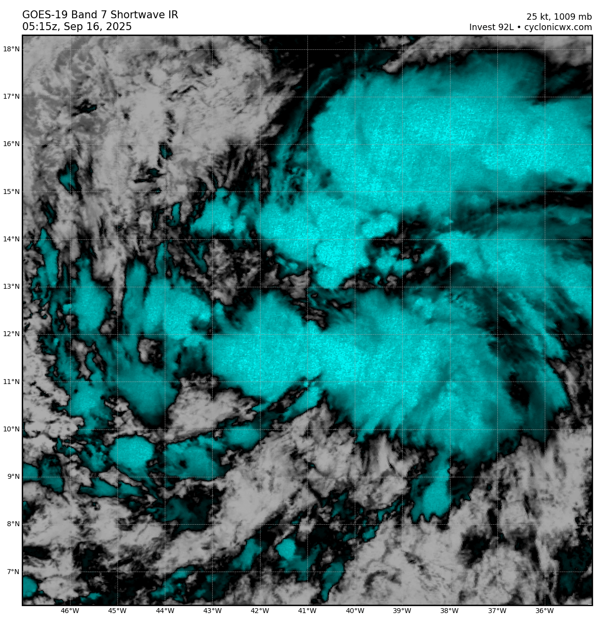
Notably, there was a sustained cell of renewed deep-convection from ~ 21Z last night through 05Z where then a new burst of covection has started a bit more poleward.
Earlier IR (dvorak) from then:
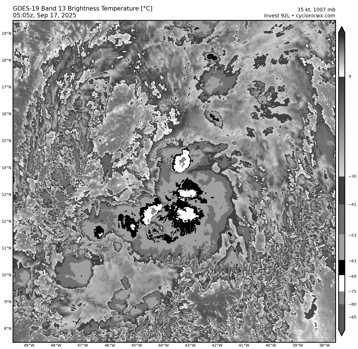
Seems likely to me this will be recurring throughout the day as a combination of dry air and very strong spin disrupt sustained convection.
~
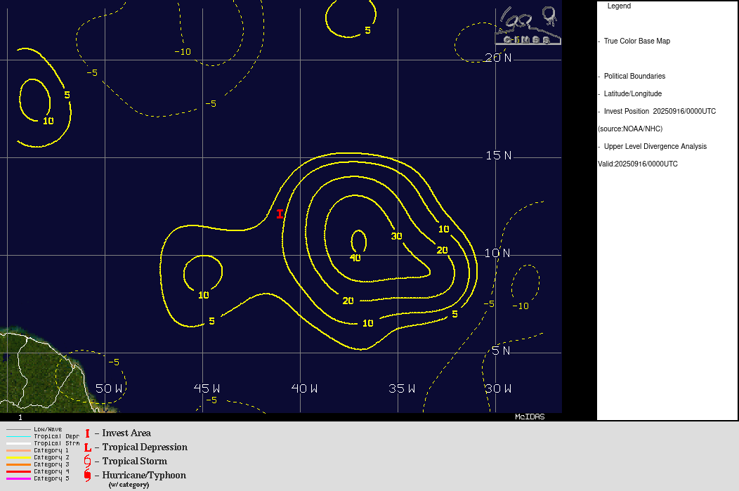
The best track for 00Z has been upgraded to a low with 35 kt winds (ROCI kept the same at 220 NM)
While the 06Z just came in reducing it again to 30kt winds (but narrowing the ROCI and RMW)
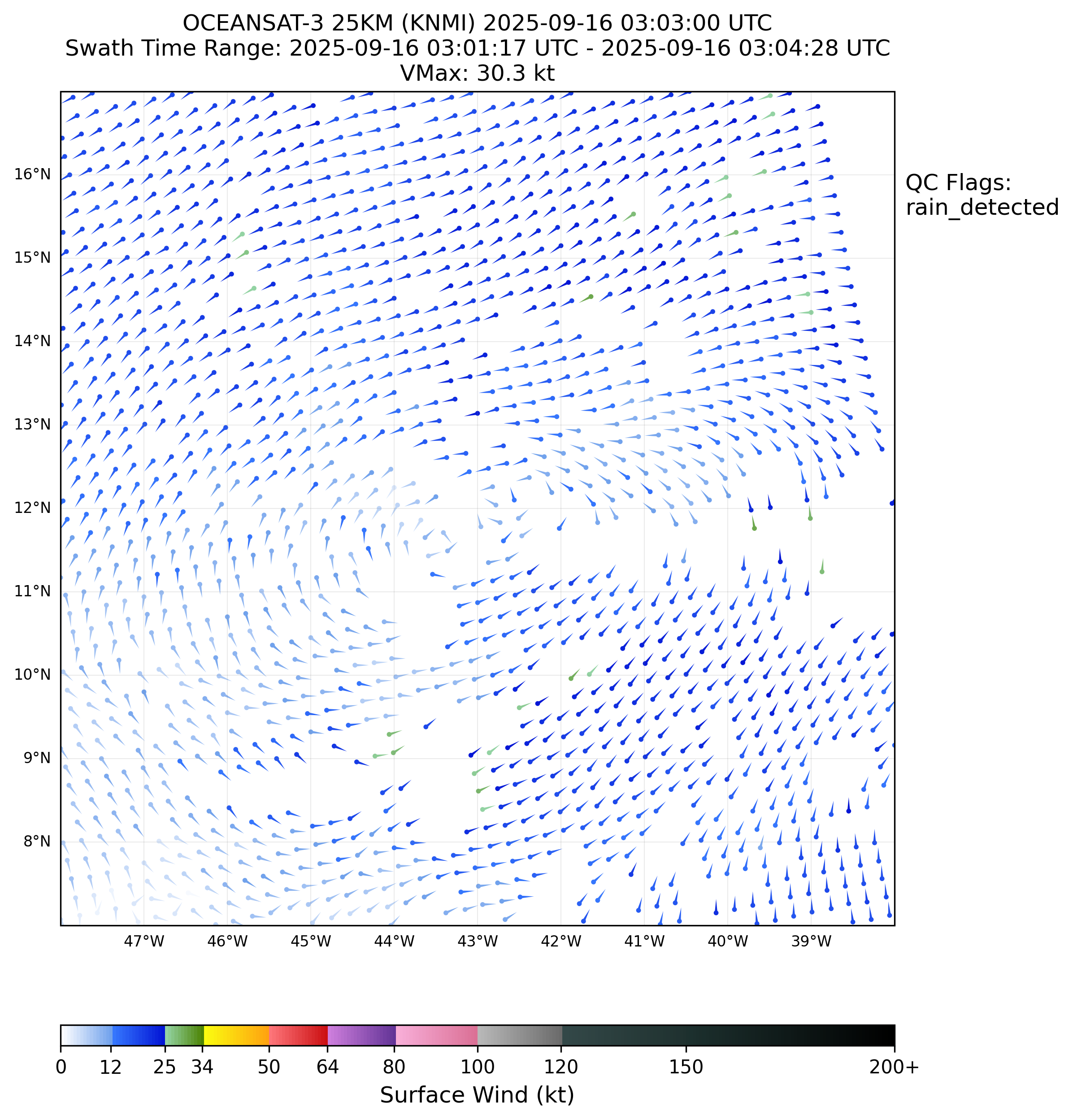
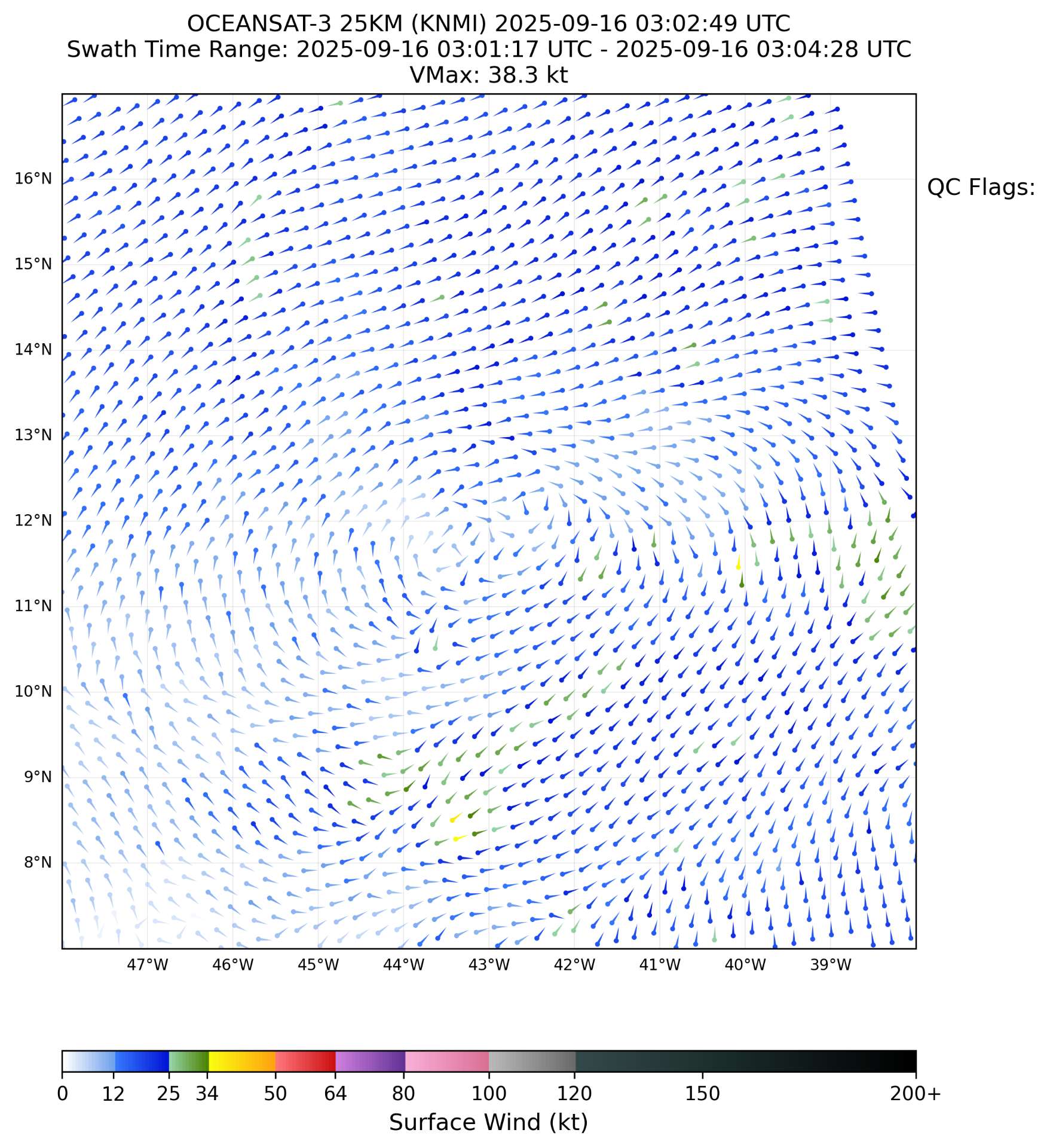
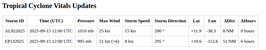
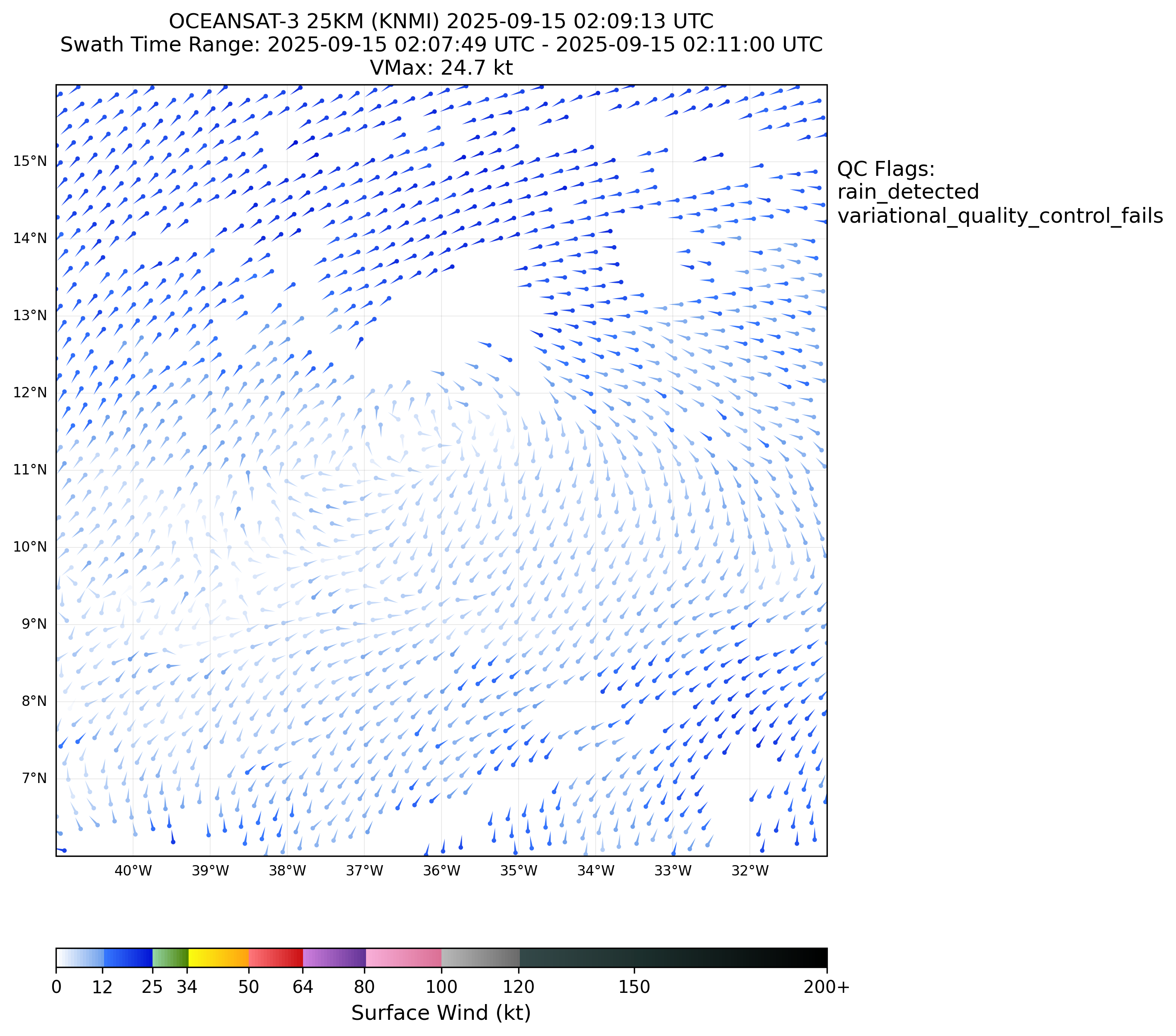
AL, 92, 2025091706, , BEST, 0, 135N, 455W, 30, 1007, LO, 34, NEQ, 0, 0, 0, 0, 1011, 200, 70, 40, 0, L, 0, , 0, 0, INVEST, S, 0, , 0, 0, 0, 0, genesis-num, 023, The recent 02:18Z Oceansat-3 pass continues to show gale force winds at a few points (1 in the QC version, and 3 in the non-QC version):
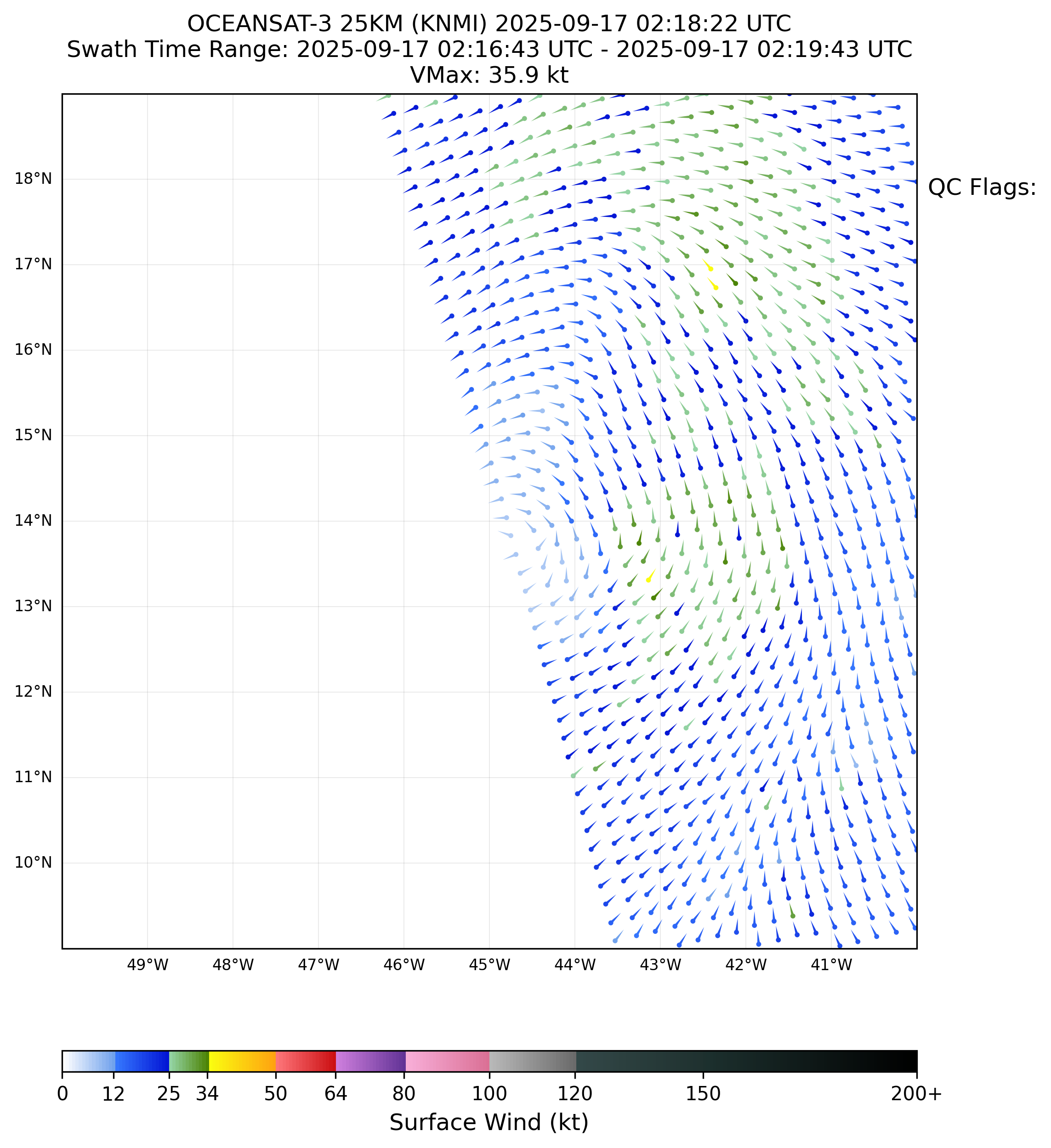
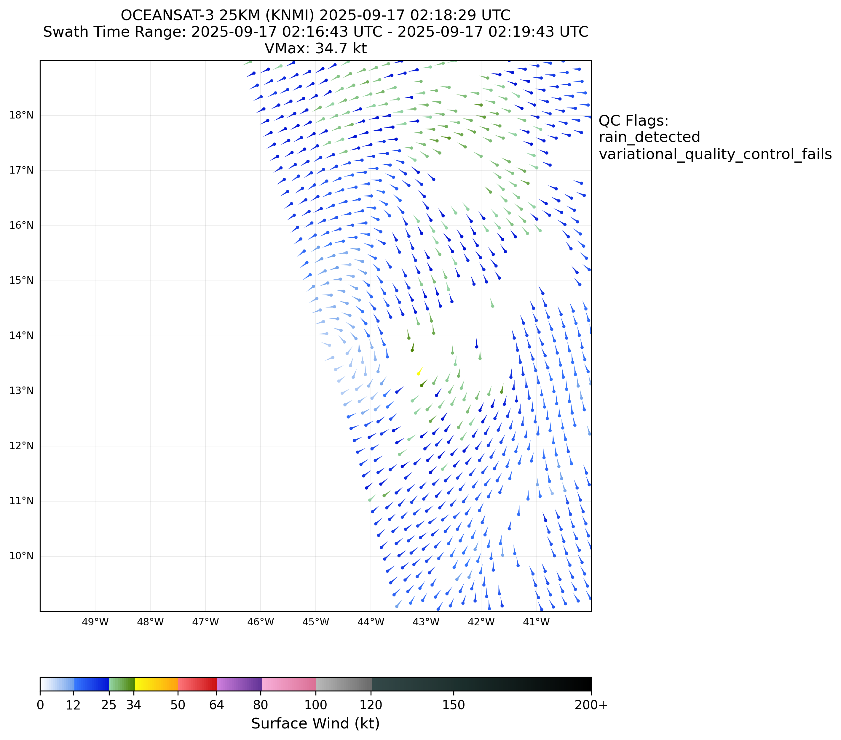
I don't know if they haven't updated or evaluated it yet or whether they have considered some other estimates in blending it...so I expect its possible them revise their 06Z estimate if the former...
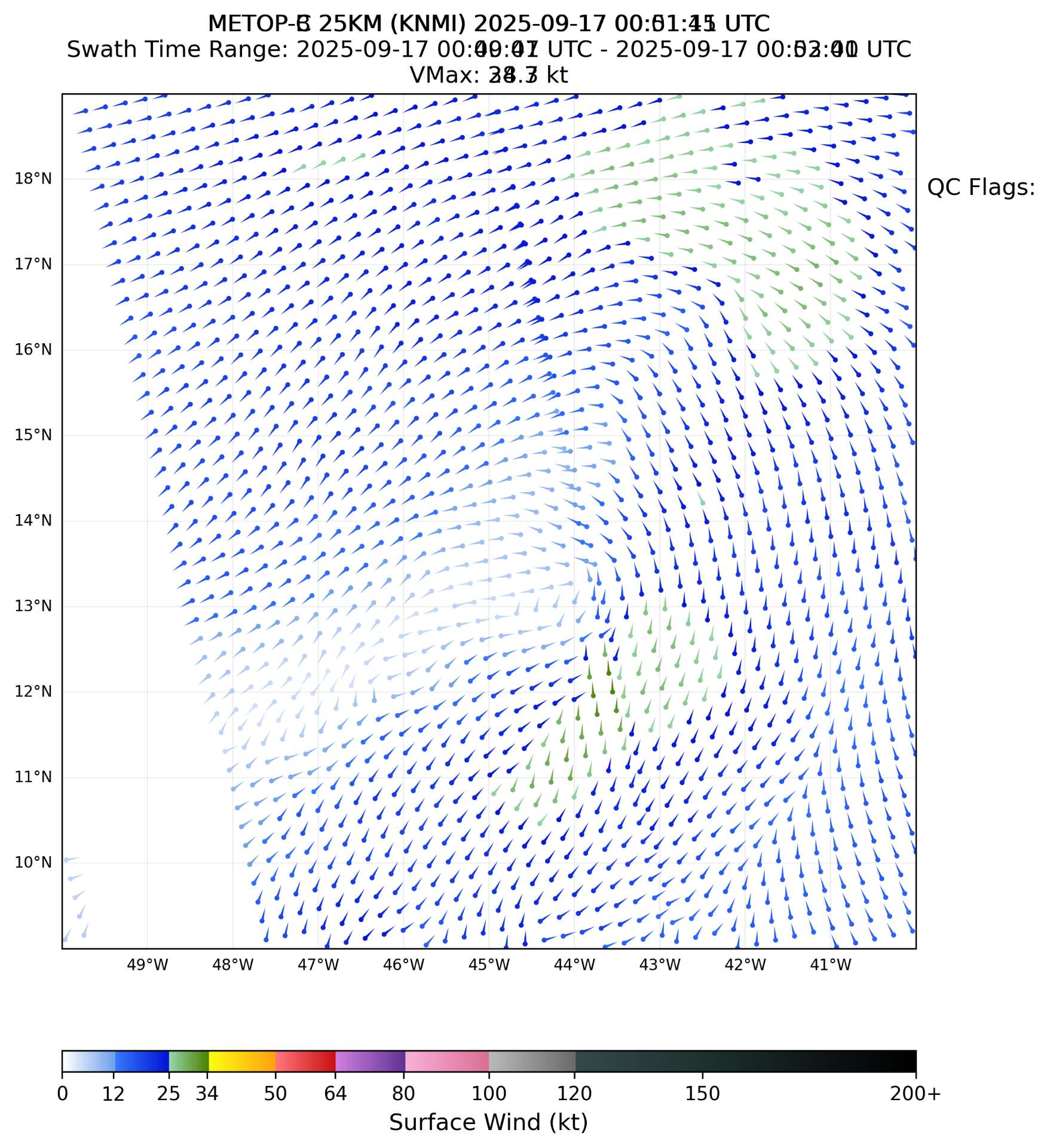
~ the 00Z upgrade is likely from the ASCAT-C pass especially (which had more, higher wind speed vectors
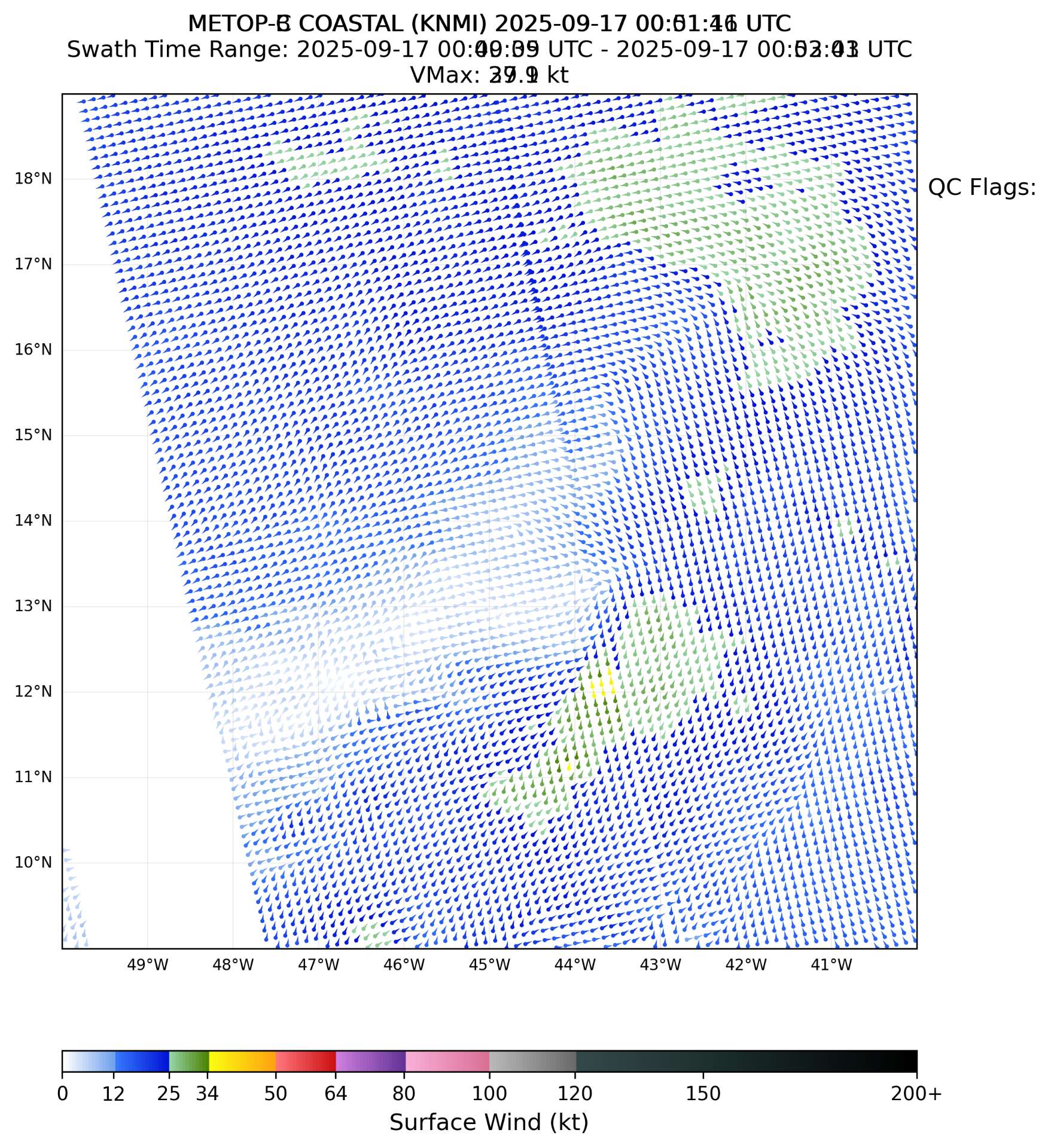
Below is the overlaid images (coastal and 25km) from the pair of METOP-C and METOP-B passes earlier (KNMI wind vectors). No closed circulation is evident. (Metop-C is the left swath) ; there were gale force winds even in the QC'd version (not shown)
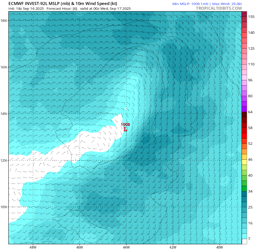
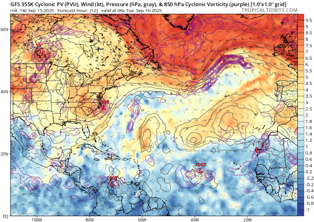
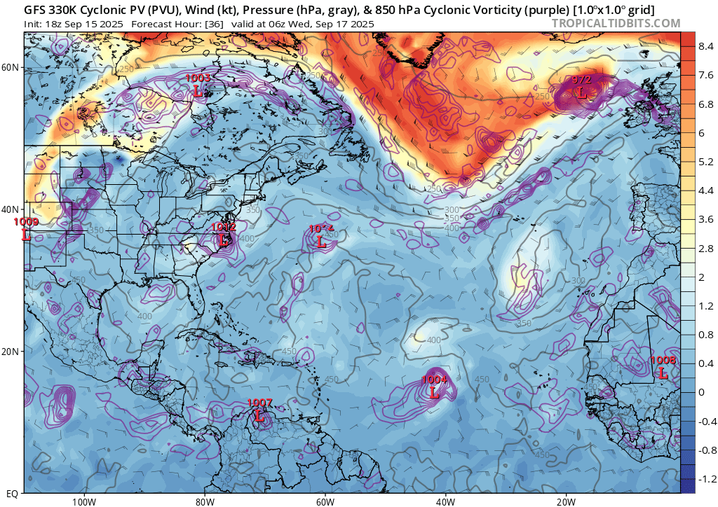
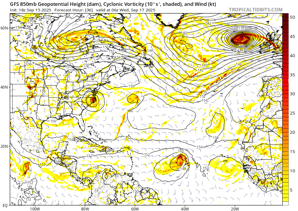
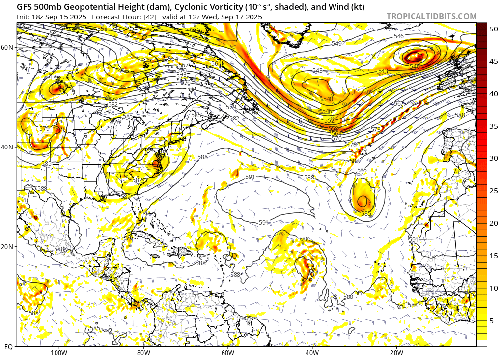
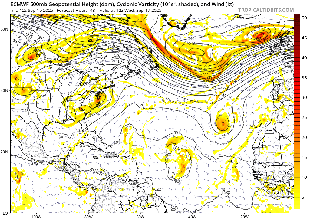
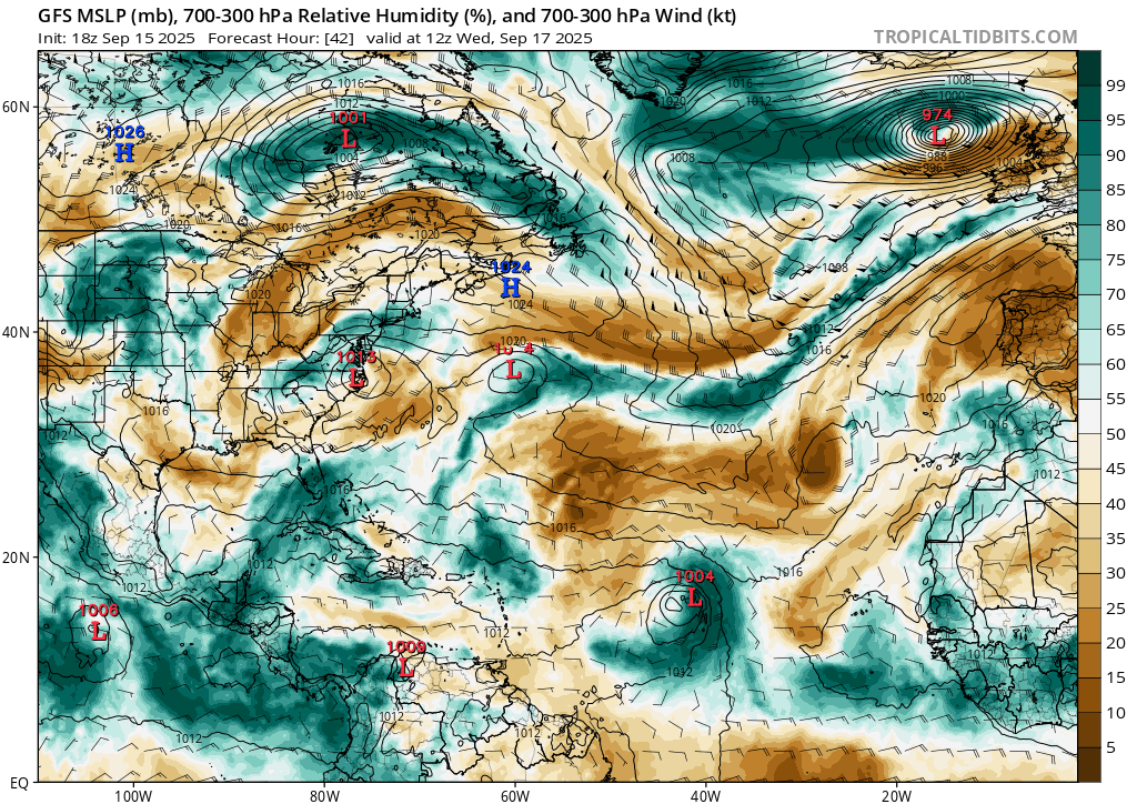
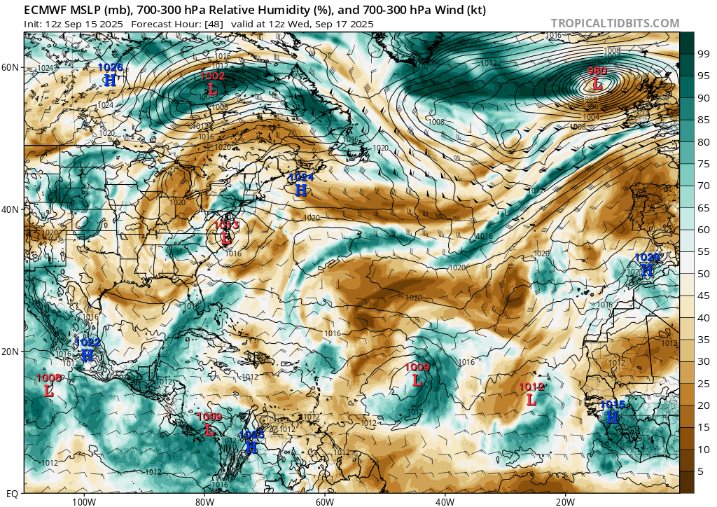
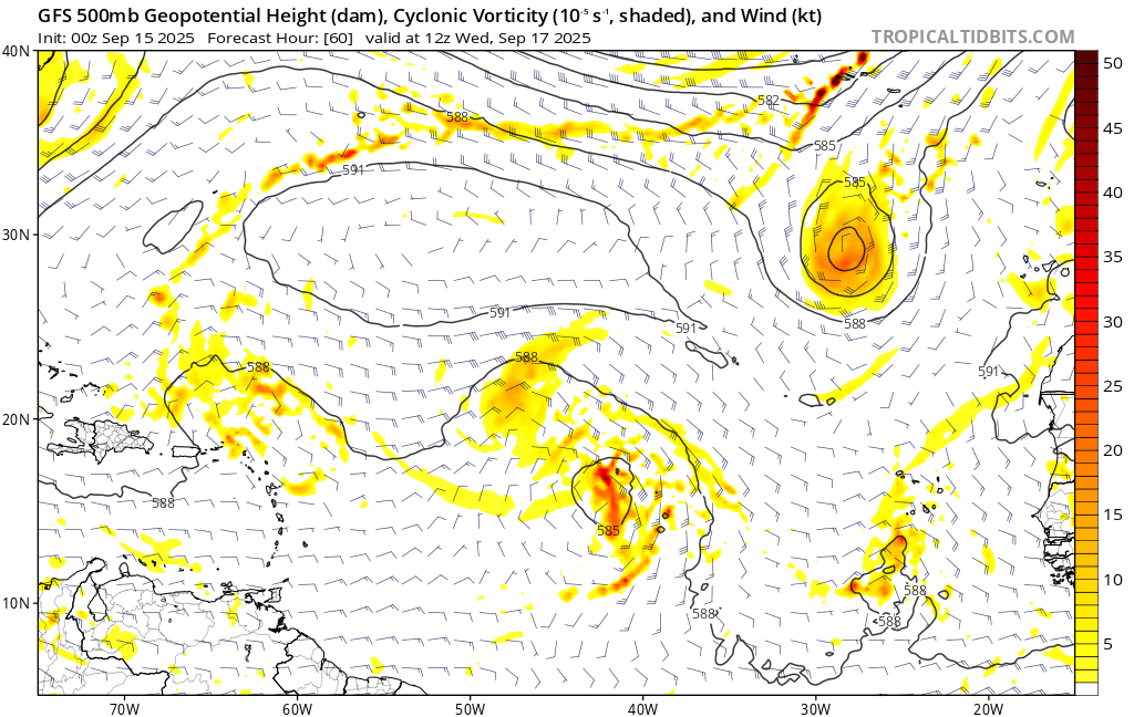
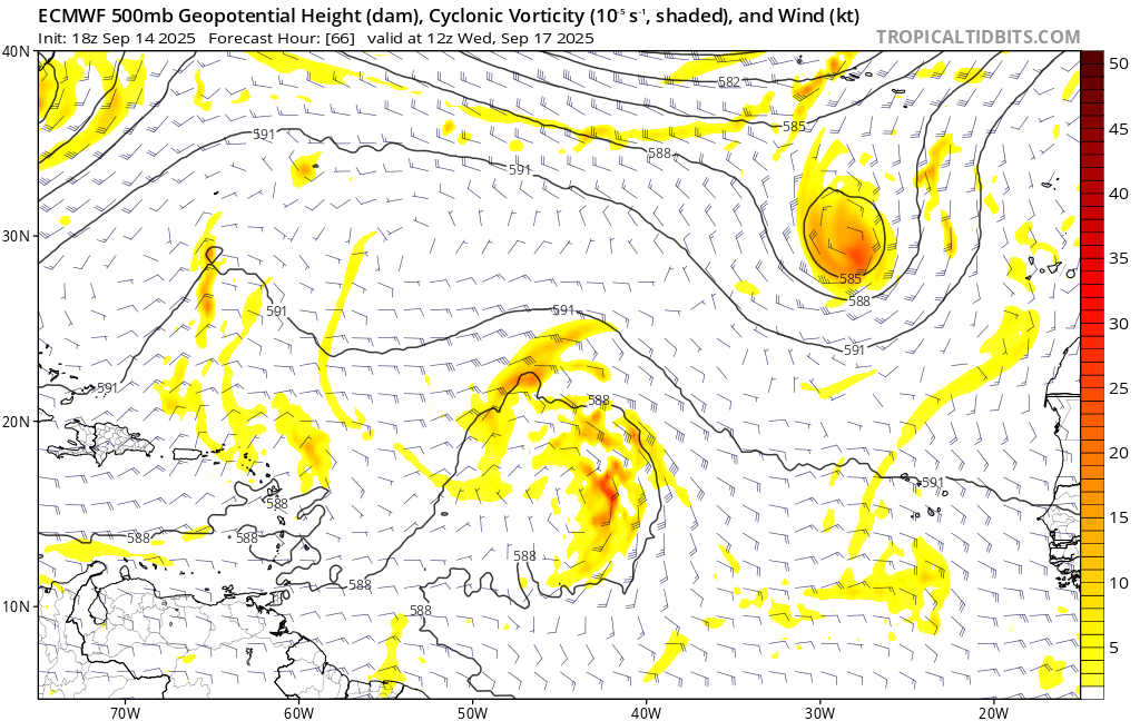
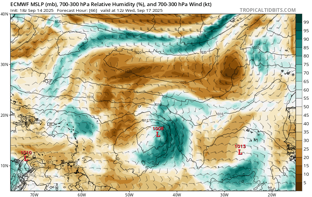
Referencing the charts on tropicaltidbits below, the surface wind field above most closely seems to match the ECMWF 18Z forecast and the GFS analysis (IMO the ECMWF/12 model appears a closer match):
The various other models appear to disagree on when the surface circulation will be closed off (and some vacillate between closed or not during the day). HAFS-A notably closes it off fairly early (06Z) with a large plume of convection at the time from satellite IR.
However since ECMWF 18Z looks the best considering the above, using that as a proxy It does not seem it will close it off until after 12Z (i.e. 12Z-15Z range)...
Referencing the scatterometer pass predictions above (which as we can see are a bit off since the center positions are also off and we don't have a well defined center); IMO, retrospectively all the models have been all initialized a bit too far east (especially yesterday's 12Z runs) since the 15/15:23Z oceansat-3 pass yesterday where my position estimate was more than 200 NM WSW (with a good deal of uncertainty) of the NHC best track near 15/12Z (as far as I am aware GFS/ECMWF don't ingest its data either).
This uncertainty in the center was noticeable in the OSPO MTCWSA products later on that shows two centers...
And also various lower quality experimental sounder products I referenced were more ambiguous as well. (Some more better position estimates from microwave or scatterometer products would have helped greatly but they seemed to be quite sparse after the oceansat-3 pass).
Given that issue since yesterday its hard to say how far even a few hours into the future whether we will get this closed low or not as the interactions with the TUTT bring more and more dry air into system, and the mid to upper level circulation are continuing to stretch poleward.
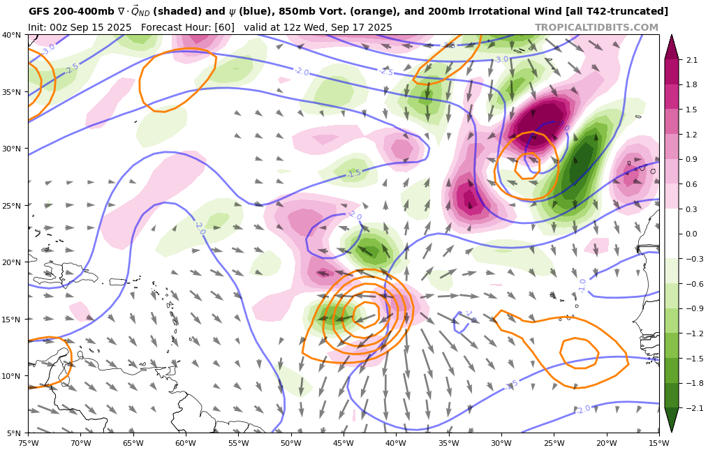
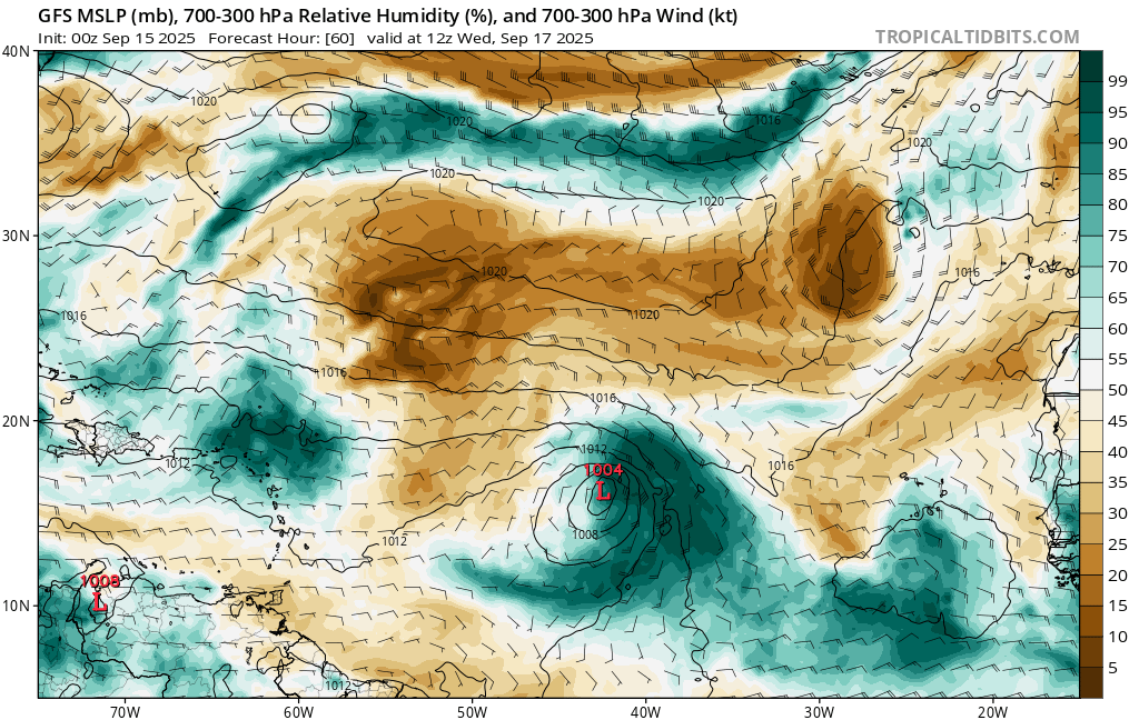
As I have been thinking for the last few days, it seems precarious of its chances of being classified a TS today with how narrow the window seems, given the interaction with the TUTT and whether it will maintain TC characteristics long enough to satisfy the NHC forecasters to classify it given the limited window of opportunity for today (deep wind shear increases and dry intrusions after 12Z will likely create an even more less symmetric / more elongated satellite appearance from looking at simulated IR satellite from the last few days of models (evident also in the 300-700mb humidity products from tropicaltidbits)
~
Perhaps the NHC follow the same pattern as TS Fernand, as given they have already met the wind criteria today for TS level winds, so long as it meets structurally the other TC characteristics it could still become a TS today but it seems very chancy to do so given the other possibilities.
Unfortunately the phase space parameters (FSU) from the ensemble data have been less helpful at forecasting for this question for this system since by those criteria the models and ensembles think its already a TC, but various analysis I reviewed show that isnt the case (soundings and model analysis make the lower levels look more and more TC like, but the upper level gets ventilated too much from the strong interaction with the TUTT to the north and takes on a more elongated characteristic like a trough).
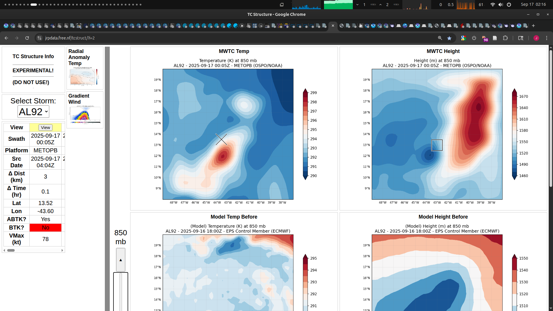
Sounding related data (Own charts) from the METOP-B 00Z pass (data from OSPO)
850 mb where it looks TC like albeit elongated:
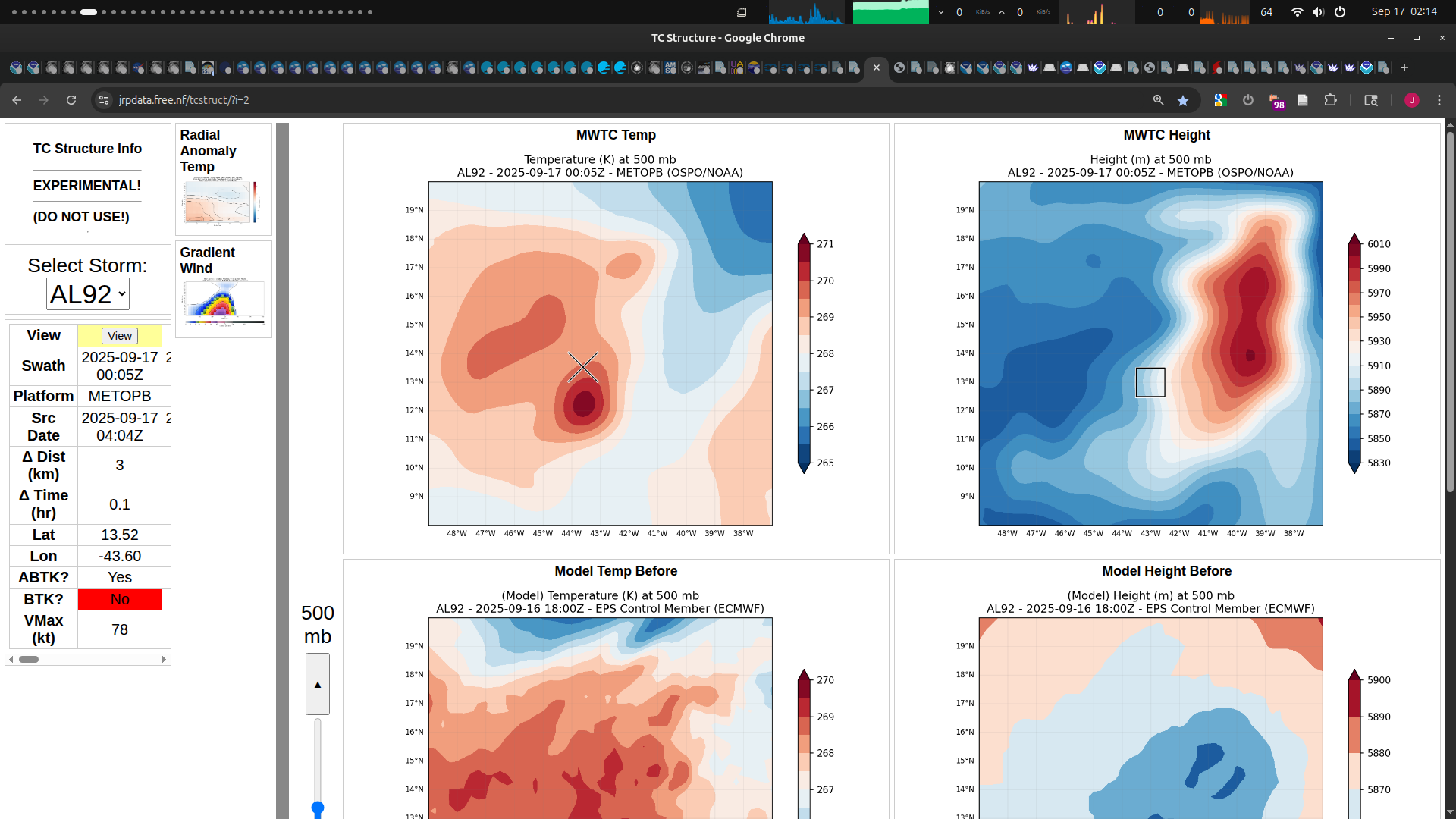
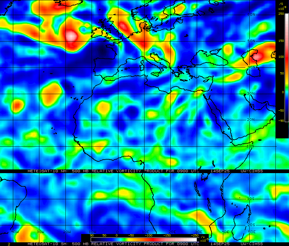
500mb, where the ventilation is strong enough to lose quite a bit of deepening:
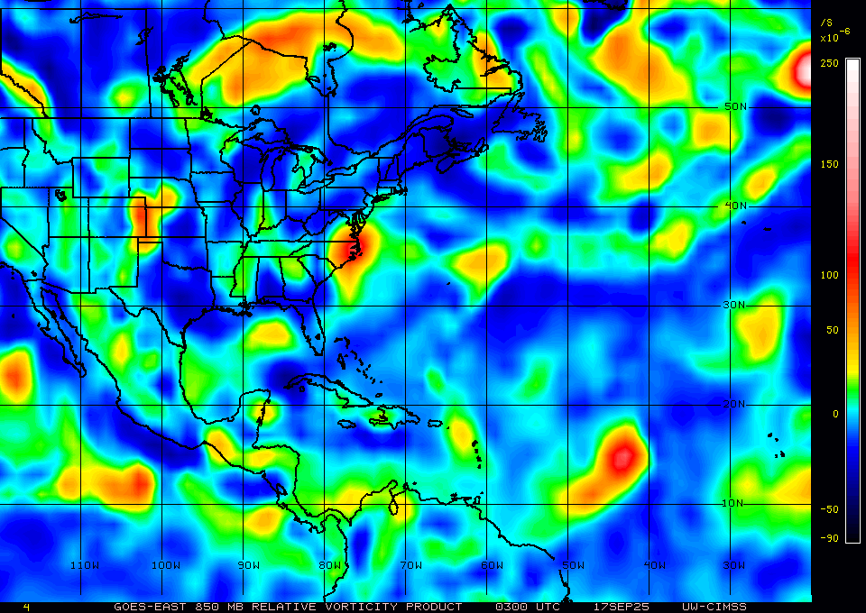
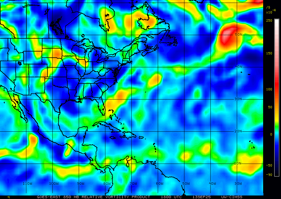
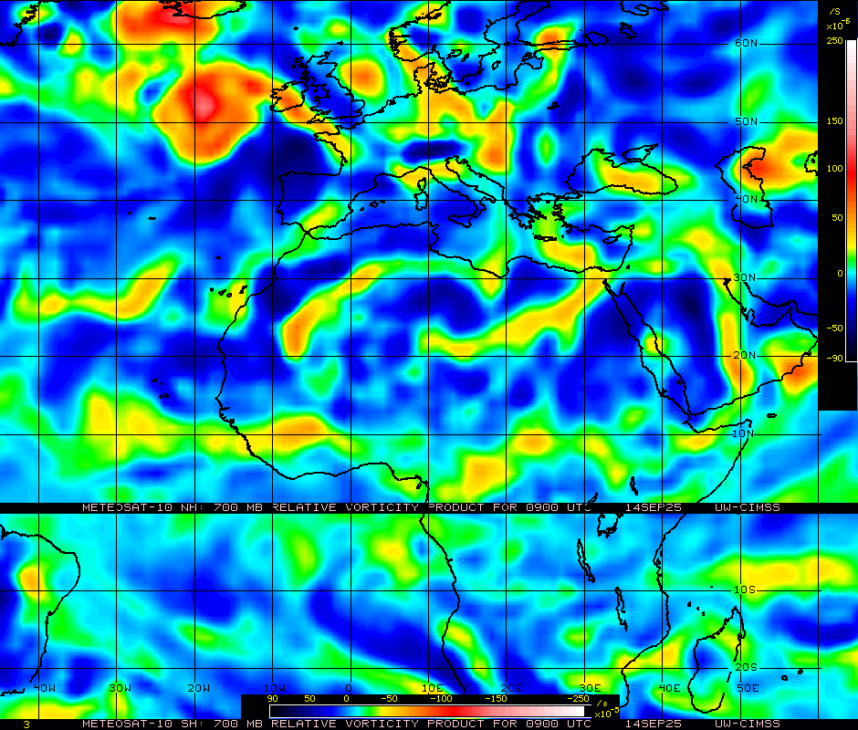
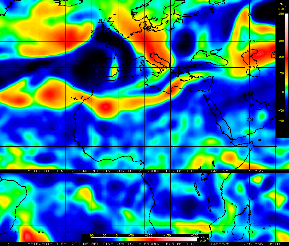
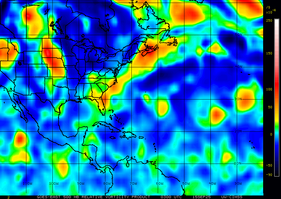
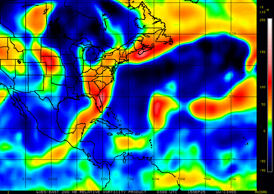
CIMSS vorticity analysis or 03Z for reference for above (not sure why 00Z is not avail).
500mb:
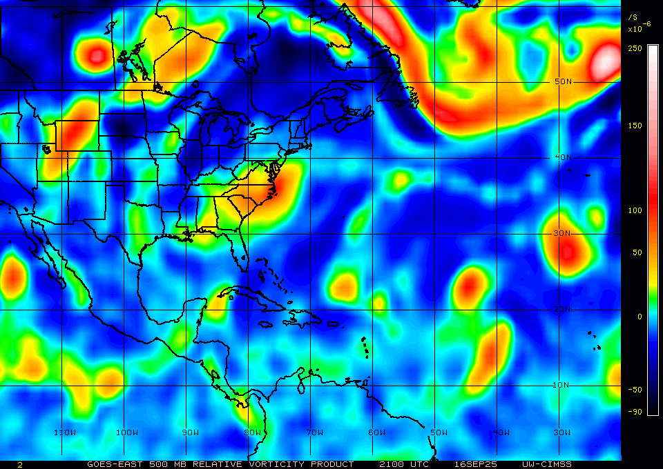
850mb:
~
As I previously believed the subjective apperance will likely continue to get worse... although its possible there will be a period of very intense convection depending on some of the models that will temporarily give it a more robust apperance.
The last subjective dvorak from SAB 15/18Z was classified it as too weak to classify, but thereafter some hours later deep convection did restart agai... The last public fix from TAFB was also 15/18Z (1.5/1.5) but so we will have to wait to see if more come later ..
I don't know if they will rely on those measures for intensity or given the earlier 00Z scatterometer pass that will be sufficient to already meet the criteria (given the model and ensemble trends its unlikely to me that the surface wind speeds will decrease today, especially given the strong and large circulation in the lower levels).
It's possible it even gets classified on the 18th if there is a long enough period of robust convection to at least temporarily give it some TC characteristics enough reason to temporarily upgrade.. but conditions seem less favorable to me despite some models and ensembles showing a strengthening trend during this time (wind shear and recovering from the dry air).
~
Most importantly, regardless of the GOES imagery there is also a GCOM-W1 pass for later today that should have full coverage given the earlier pass prediction that might be used to support classifying it as a TC if there is a clear ring structure (assuming the track isnt way off later on today, which it may be as the METOP-B 100% pass was already a 50% partial when it should have been 100%); the latest 06Z position though I think is closer than the previous ones being more west and so its possible the error for the rest of the pass predictions coverage will go down (i.e. in some of the much earlier subsetted ensembles I recall it showed the model center moving roughly almost straight north at one point).
~
I don't have pass predictions for the other SSMIS satellites and the new WSF-M though so those might be wildcards as well...
06Z NHC outlook upgraded to 80%/90% for 92L and now includes an AEW that might develop later on....
For the North Atlantic...Caribbean Sea and the Gulf of America:

Central Tropical Atlantic (AL92):
A large area of showers and thunderstorms continues to show signs of
organization with a broad area of low pressure located about midway
between the Windward Islands and the coast of west Africa.
Environmental conditions are conducive for further development, and
a tropical depression or storm is likely to form in the next day or
two as the system moves west-northwestward or northwestward at 10 to
15 mph over the central tropical Atlantic.
* Formation chance through 48 hours...high...80 percent.
* Formation chance through 7 days...high...90 percent.

Eastern Tropical Atlantic:
A tropical wave emerging off the west coast of Africa is producing
an area of disorganized showers and thunderstorms. Some slow
development of this system is possible towards the mid to latter
part of this week as it moves westward at 15 to 20 mph, moving from
the eastern to central portion of the tropical Atlantic.
* Formation chance through 48 hours...low...near 0 percent.
* Formation chance through 7 days...low...20 percent.
~~~~
~~~~
Based on the below I think there is enough reason to slightly discount the objective probabilities from the overall ensembles (the complexity of the TUTT interaction, the two internal vorticity centers, and the surviorship analysis) to think today is less likely than indicated overall.
And overall possibly less likely than the ensembles suggest for the 17th as well, so I will hedge a bit more conservatively on Other than indicated by the ensembles given (and accordingly suggested by the latest NHC outlook which is as aggressive as the ensembles).
~~~
When it became an invest yesterday, the presentation at the time appeared to show a very healthy system with good banding (based possibly on the current favorable outflow, and I suspect that might be a theme recurring now as it looks much more symmetric for the moment, however its possible it is still hiding an elongated structure in the lower levels per the last CIMSS 700mb RVOR...
The system also seems to have a relative narrow window to develop into a TS for the current market dates (which is just 16/17 and Other now...)
~ Very, very, long thread:
I've finally written a commentary too long for a manifold post, so the analysis goes in pastebin:
~~~~
Earlier today:
~~~
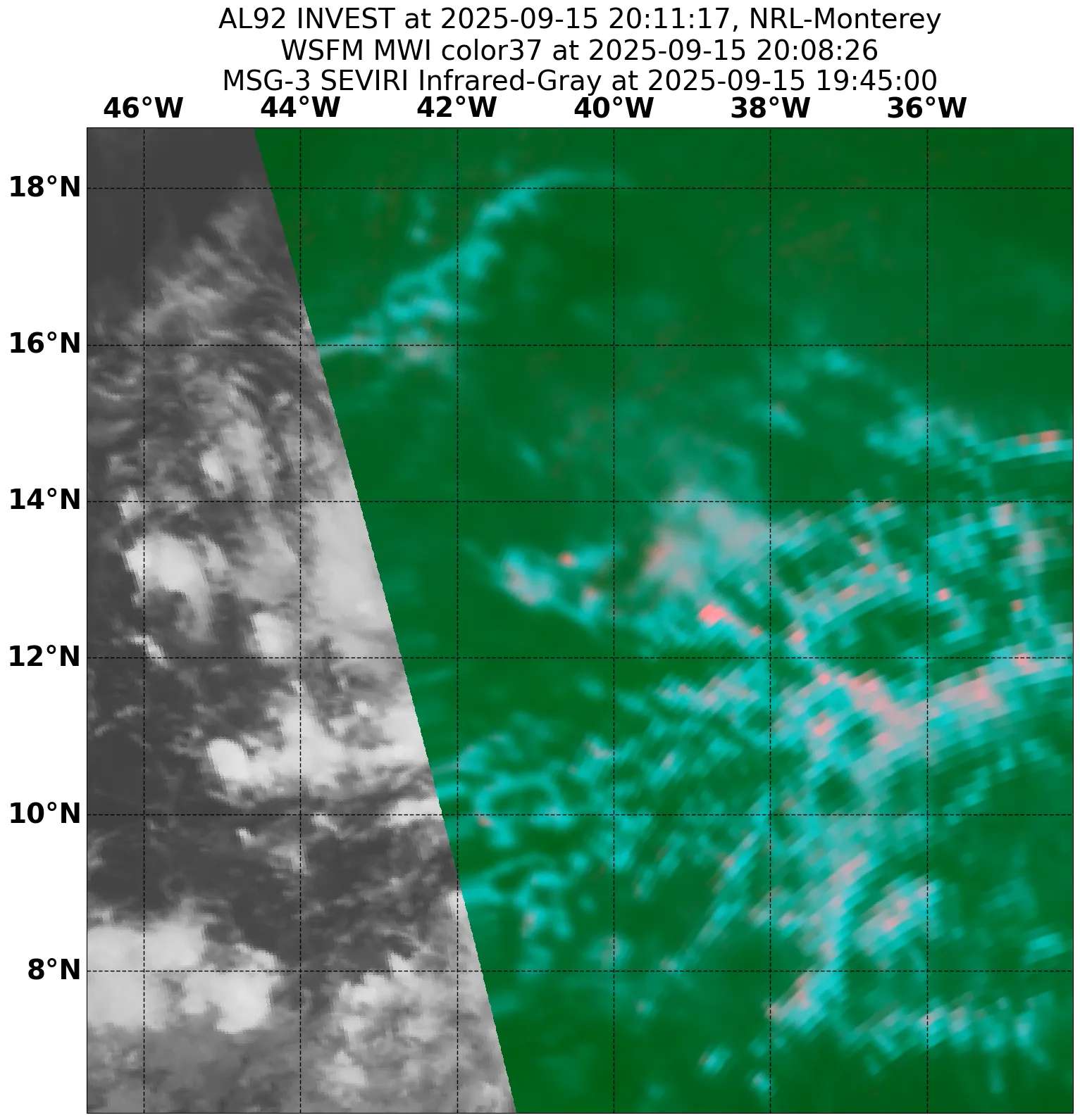
Earlier 37GHz PCT microwave pass imagery from the new WSFM satellite (NRL) showing its elongated state:
More recent satellite imagery:
~~ Some of the below images will be more and more dated...
~~ from a bit earlier:
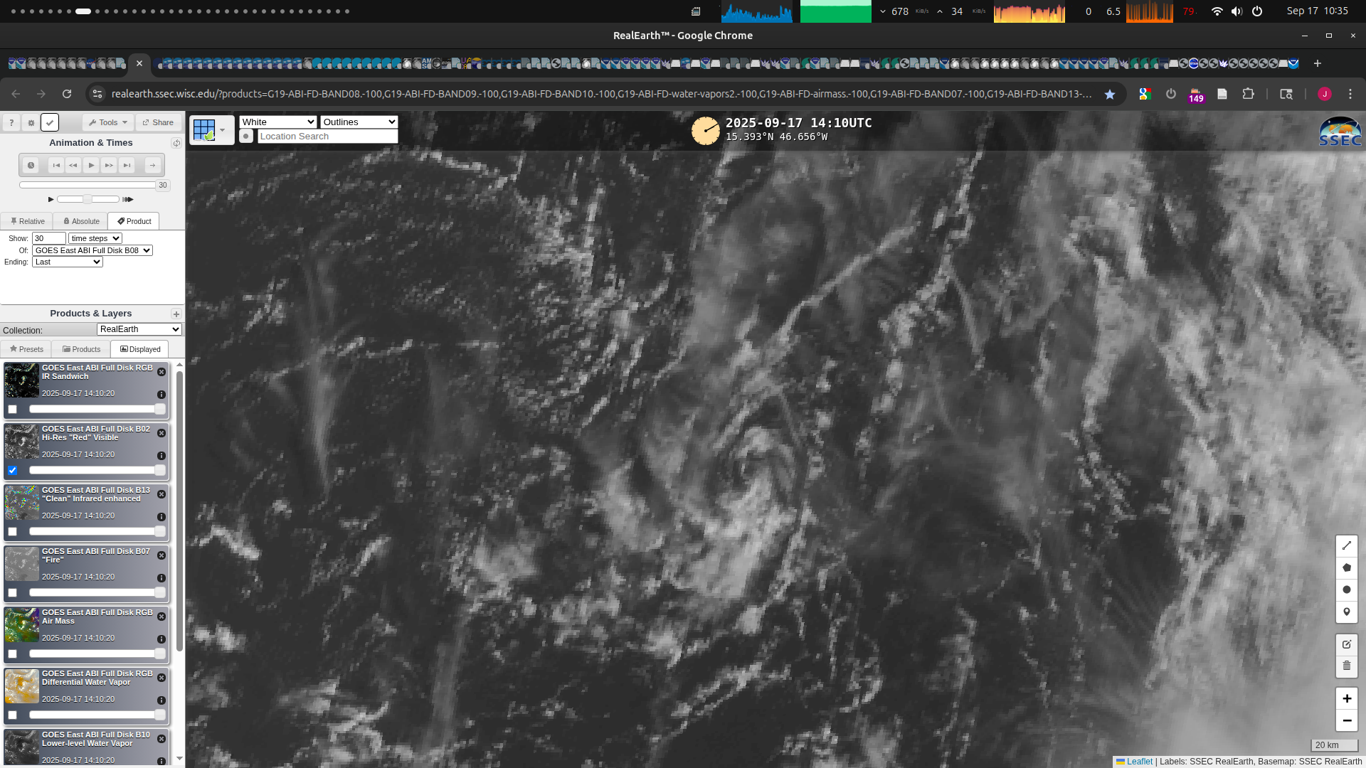
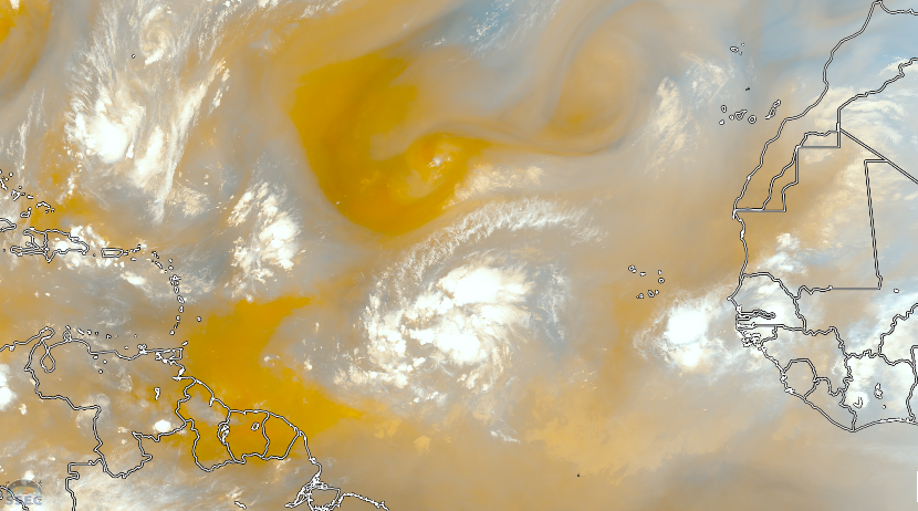
As RAMMB/CIRA's Slider GOES imagery is behind, I reference CIMSS realearth:
Tropical Airmass:
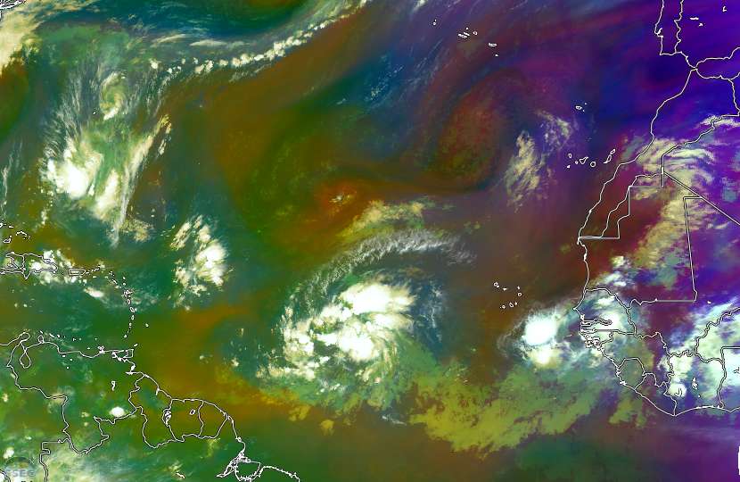
Differential water vapor:
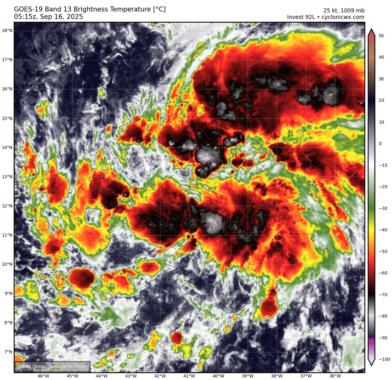
EUMETSAT (METEOSAT-12) shows the deep that has picked up with cloud tops reaching-85C most recently...:
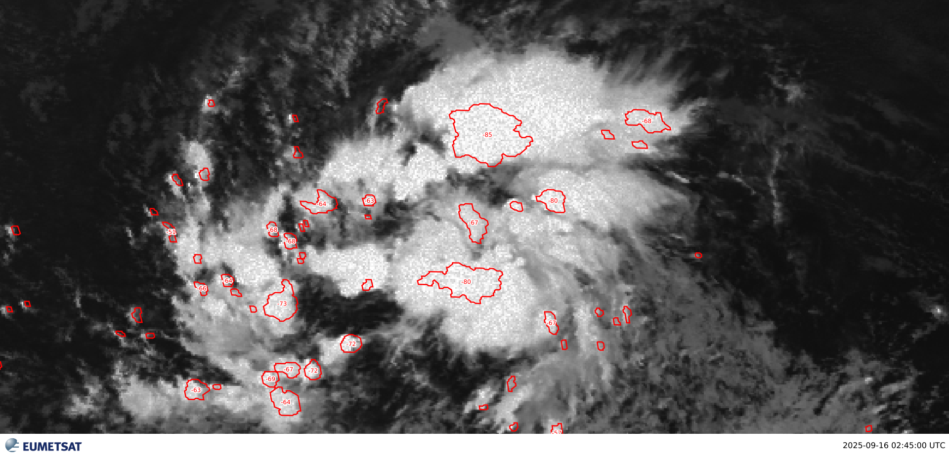
Most recent scatterometer pass from a couple hours ago:
More dated scatterometer pass from yesterday:
CIMSS:
RVOR 500mb:
RVOR 500mb (Earlier and more recent):
Aftaer reviewing the latest satellite imagery showing its elongated shape still I went back to look at the latest 700mb RVOR...
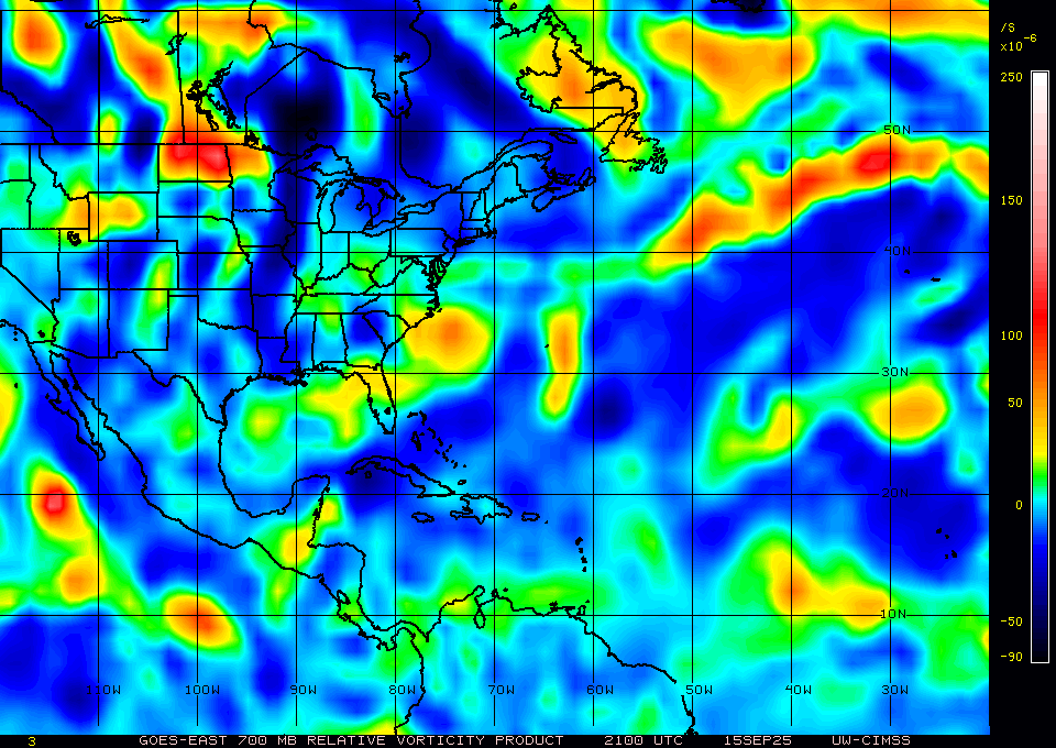
The two circulation centers there are still present.
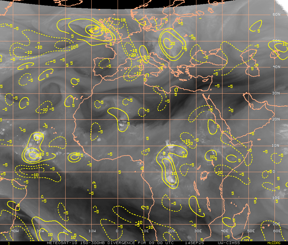
Divergence:
tropicaltidbits:
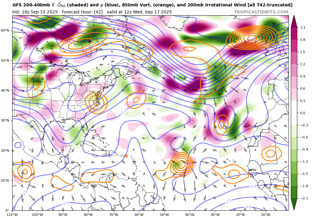
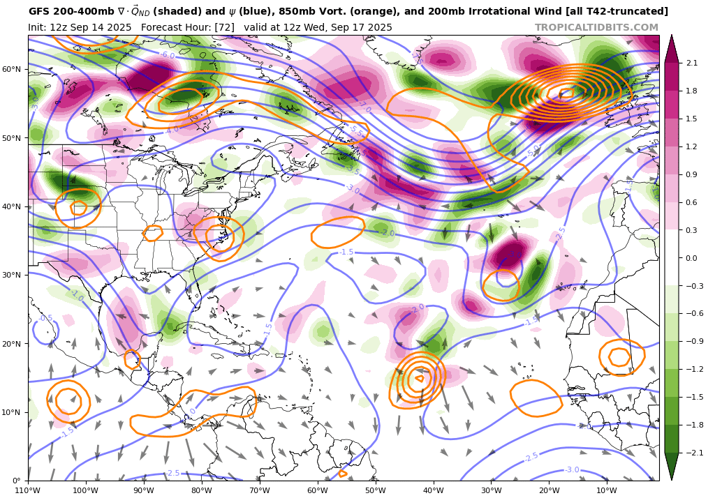
Referenced charts from GFS/ECMWF (and comparisons from 14/12Z to latest available)...


@parhizj If I had a nickel for every time I created an Atlantic tropical storm formation market at start of peak season in a La Nina and it stayed open for multiple weeks, I would have two nickels, which isn't a lot, but it's weird that it happened twice
I thought last year's Aug - Sep inactivity was super anomalous and then this year does the same thing but stays inactive for an additional week...
@SaviorofPlant Trust me bro, this is the one for sure. Certainly we won't have to wait until the next AEW ... certainly.... lol
For reference, this is the current NHC outlook from 06Z:
Tropical Weather Outlook
NWS National Hurricane Center Miami FL
200 AM EDT Sat Sep 13 2025
For the North Atlantic...Caribbean Sea and the Gulf of America:
Eastern and Central Tropical Atlantic:
A tropical wave located between the west coast of Africa and the
Cabo Verde Islands is producing limited shower and thunderstorm
activity over the far eastern Atlantic. Dry and stable air will
likely limit this system's development over the next few days, but a
tropical depression could form by the middle to latter part of next
week while moving west-northwestward at 10 to 15 mph over the
central tropical Atlantic.
* Formation chance through 48 hours...low...near 0 percent.
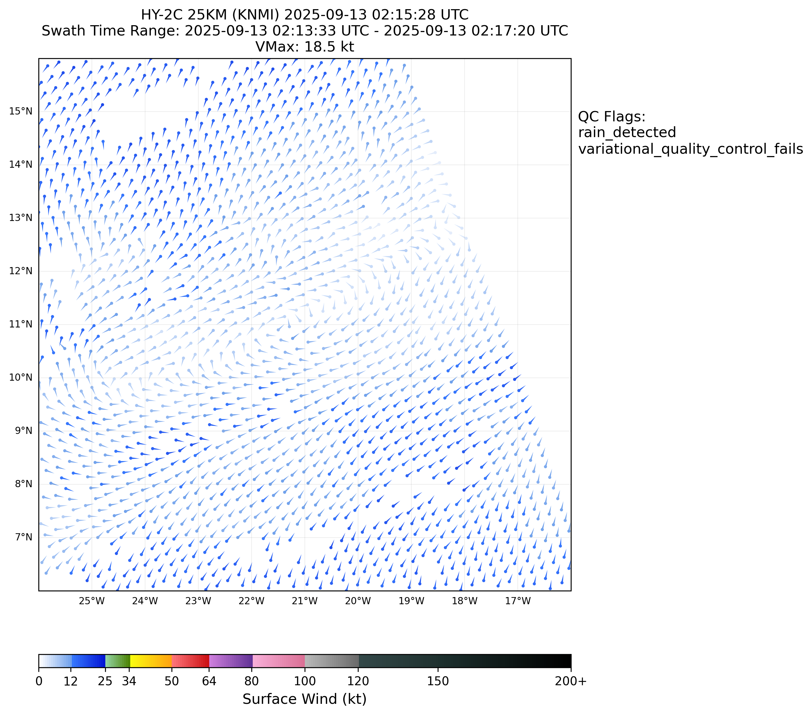
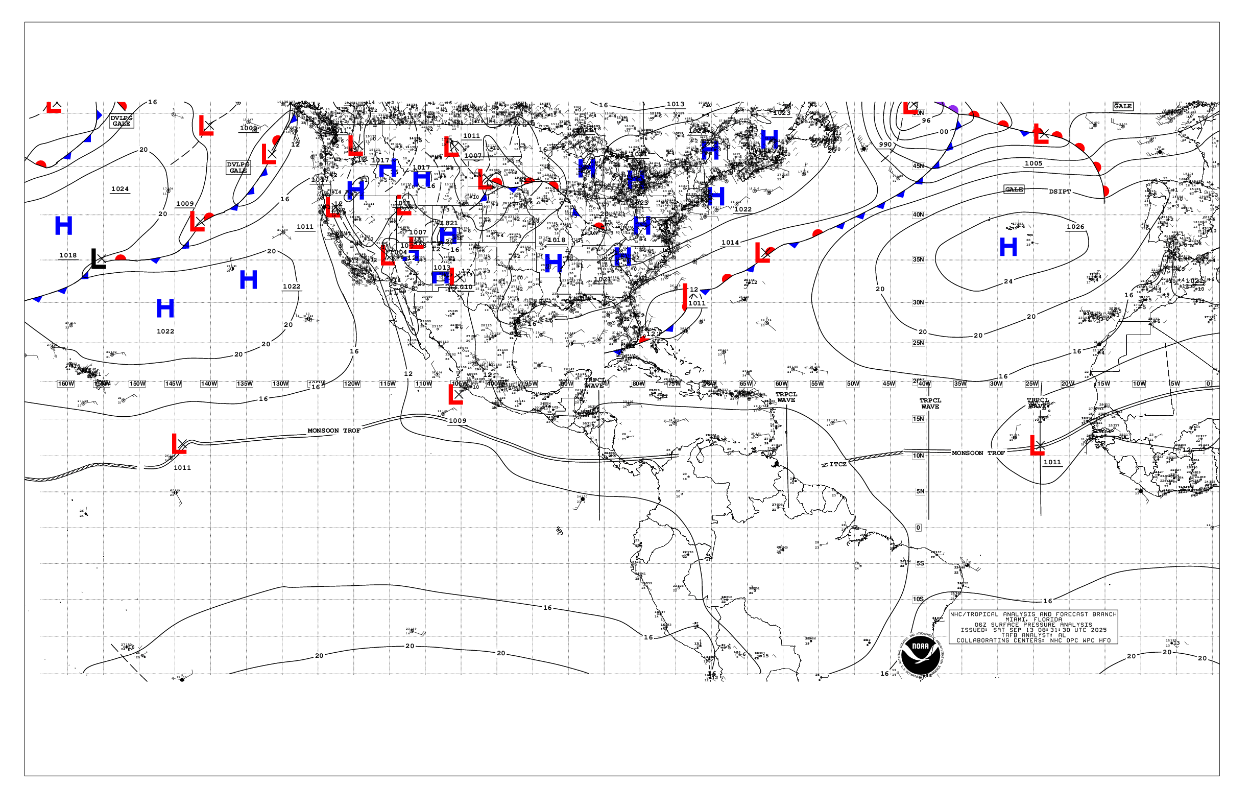
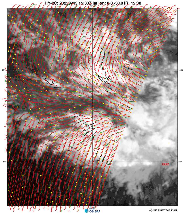
* Formation chance through 7 days...medium...40 percent.There is a broad circulation with a surface low (~21W at 02Z per a HY-2C scatterometer pass) associated with the current tropical wave marked near ~ 24W @ per TAFB 06Z analysis (1011 mb).
06Z TAFB:
GFS 00Z forecasts a new AEW coming off the coast (long ago forecast) some time late tonight / early tomorrow which will eventually develop a circulation, and per various ensembles from 00Z one or both of these lows starts to have a chance to start to develop in about 3-4 days or so. Per GFS 00Z the latter system I would guess has a higher chance of actually developing at the moment -- with the story that the previously mentioned low near 21W will move generally W and WNW producing enough moisture and instability to give a chance for the trailing circulation to develop.
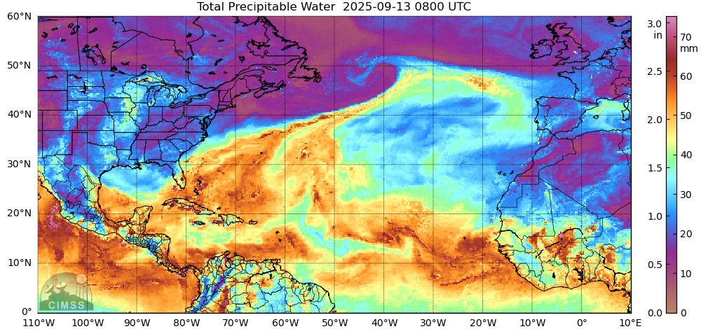
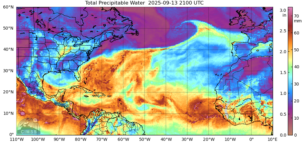
The current low from the tropical airmass product below seems to be already producing enough moisture for the coming wave (seemingly likely going to produce a good pocket):
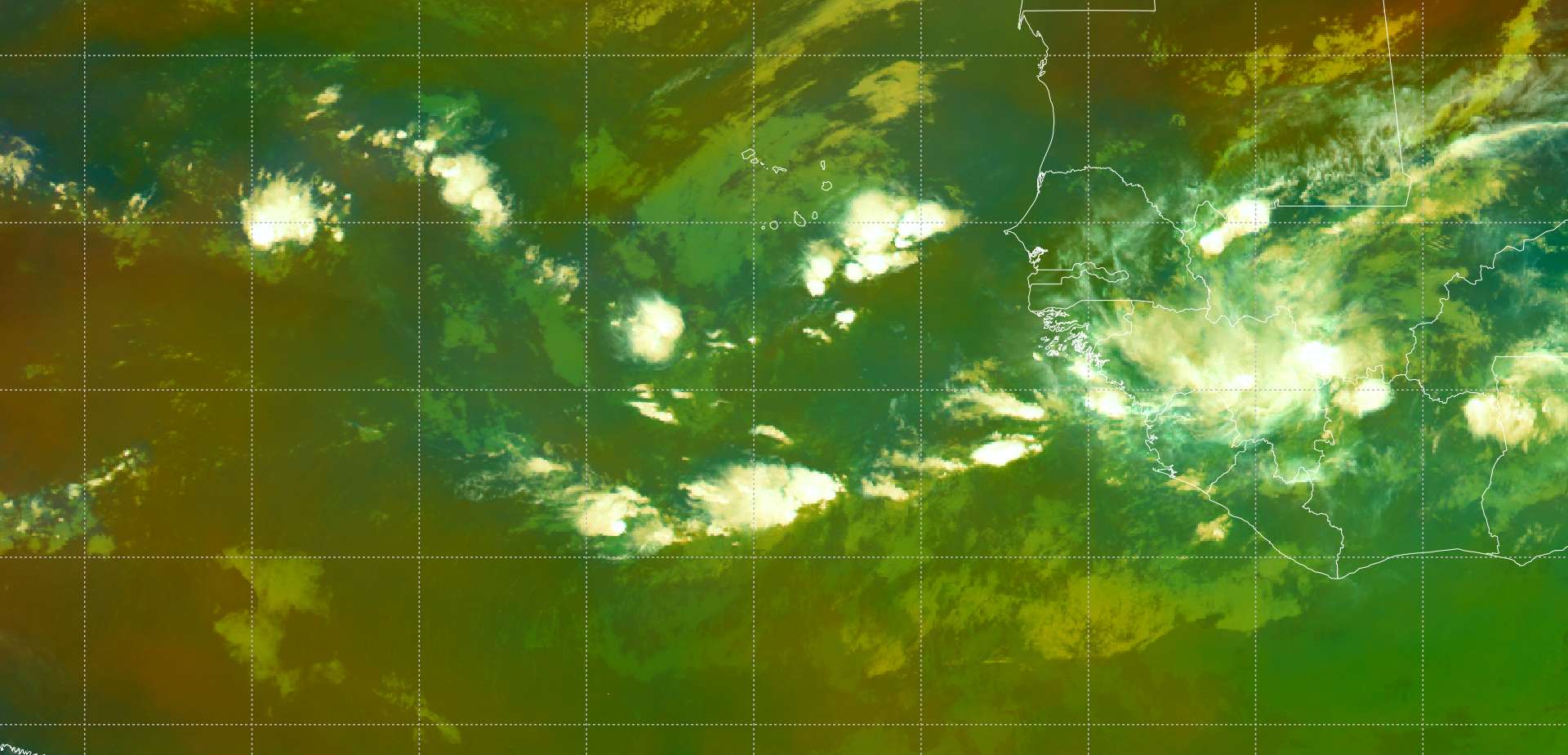
08:30Z METOP-12 (EUMETSAT):
MIMIC-TPW (CIRA)
Looking at earlier CFS forecast and the GFS forecast it does seem like wind shear might also possivbly limit its chances (as there is a narrow corridor of low wind shear currently)
06Z Deep wind shear (CIRA):
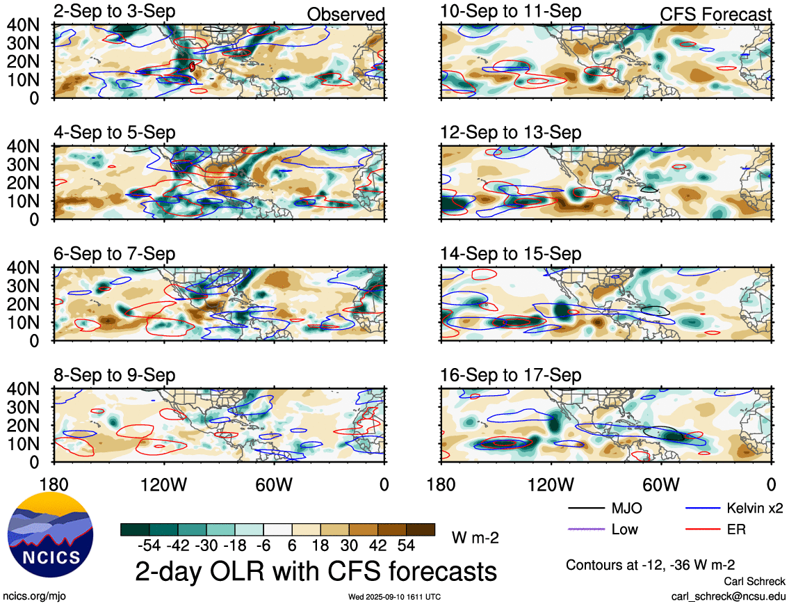
The various forecasts related to the MJO I looked at (NCICS and ECMWF) appear to show it decidedly moving over the NE pacific for the next 5 days or so but should also start to extend into the Atlantic afterwards, and should favor further development of Gabrielle if it does actually develop..
ECMWF:
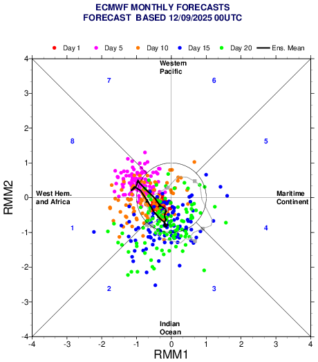
12Z ensembles probabilities have slightly increased...
NHC outlook has also increased to 0/50%
There was less moisture over West Africa earlier in the evening so its not clear how weak the wave will be and whether the above story is still plausible; ECMWF did not like this scenario and GFS/12Z seems to agree, but the ECMWF did show some weak circulation coming off East Africa and eventually combining later with the system west of it. This seems more likely now to me...
Looking at the TPW and vorticity products from CIRA, the broad low has increased its spin again but not much convection, especially less with the surface low that is aligned further north (TAFB analysis still has it marked) and I only see weak evidence of a surface circulation still from scatterometer data though... it is still disorganized; I didn't look too closely at recent satellite imagery to verify this...)
Latest NHC outlook has been upgraded to 10%/70%
ZCZC MIATWOAT ALL
TTAA00 KNHC DDHHMM

Tropical Weather Outlook
NWS National Hurricane Center Miami FL
800 AM EDT Sun Sep 14 2025

For the North Atlantic...Caribbean Sea and the Gulf of America:

1. Eastern and Central Tropical Atlantic:
A tropical wave over the eastern tropical Atlantic is producing a
large area of disorganized showers and thunderstorms. Although dry
and stable air is expected to limit development during the next
couple of days, gradual development is anticipated thereafter, and a
tropical depression is likely to form during the middle to latter
part of this week as the system moves west-northwestward at 10 to 15
mph over the central tropical Atlantic.
* Formation chance through 48 hours...low...10 percent.
* Formation chance through 7 days...high...70 percent.


Forecaster Hagen
Based on the below I've mostly stuck to the ensemble guidance on the probabilities as I don't find a good reason not to ...
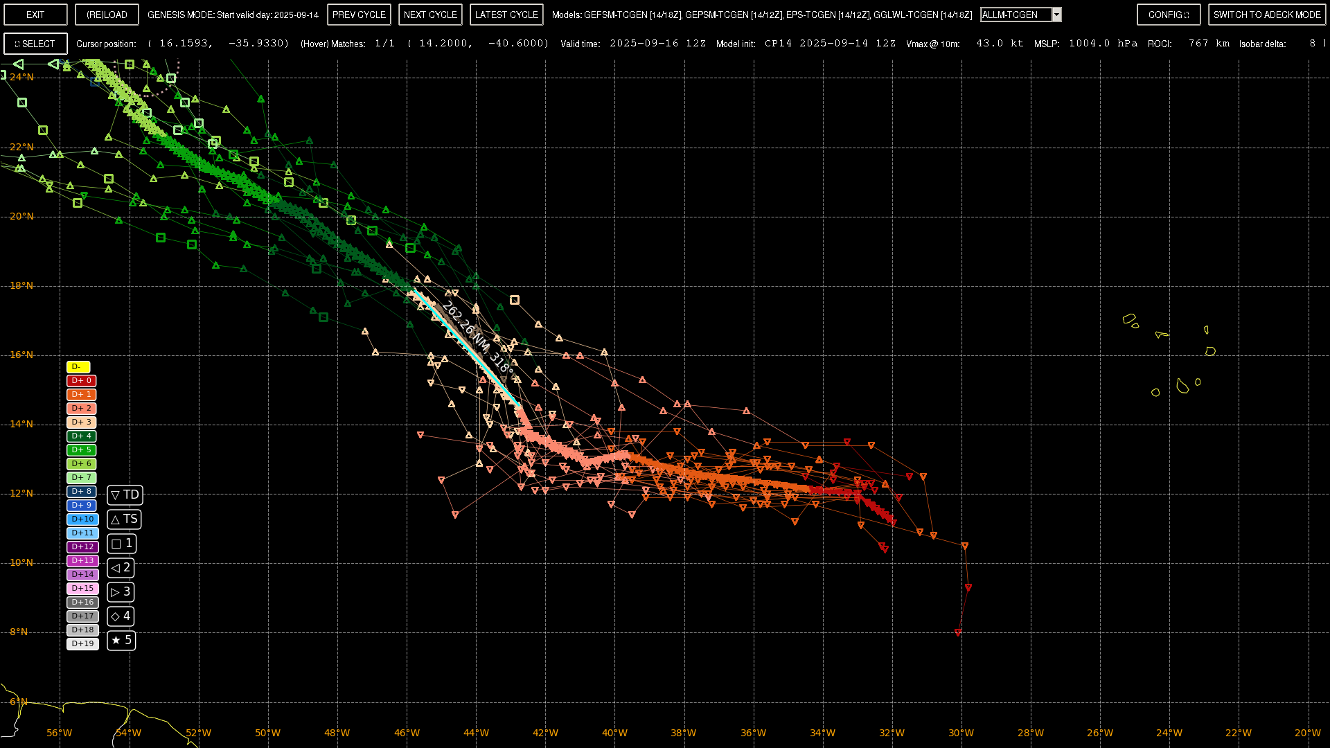
~ ~ Super Long-thread:
The 00Z ensembles appear to becoming in sharper agreement and have slightly moved forward the development of this system (Google has a high majority of its probability on a single day), so it will appear to this market that the probabilities have drastically increased today, as there has been no 18th+ days in the past to allocate for its development... (i.e. I would have given 15% yesterday for development on the 18th)
I didn't look at the track position for the ensembles too closely yesterday (as I looked at only a pair of deterministic models), but today the track for the 00Z ensembles seems to have shifted, generally more poleward of where they were previously, and the track is a bit more wobbly. The limited members with points indicate the center will shift NW today (per the few tracks that have points presently). This development favors earlier recurvature which is good news for the east coast of the US if the models are correct.
To try to isolate the system for analysis I exclude some tracks in the area that lack points 3 days from now between 38 W and 48 W.
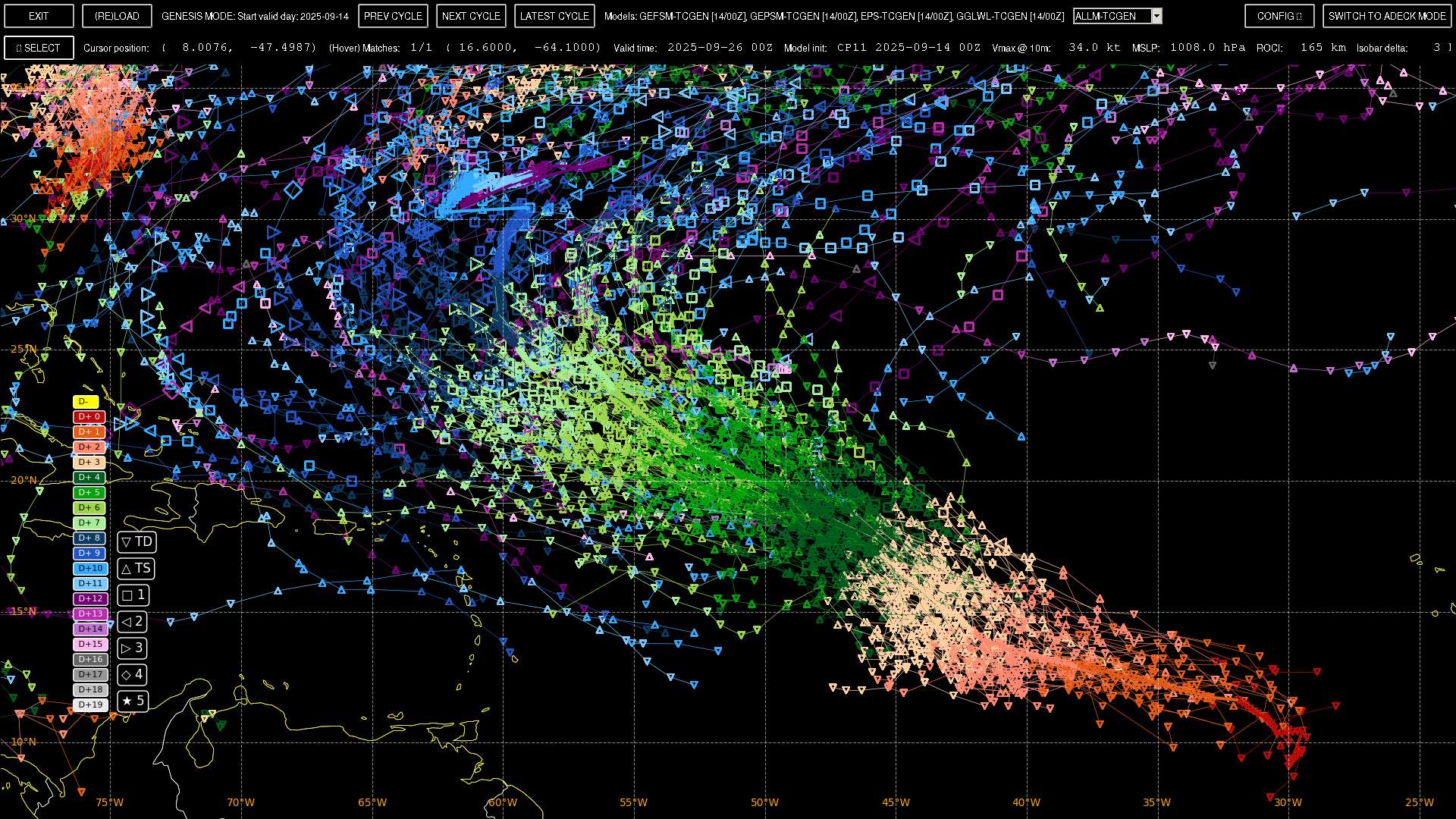
Sampling a region of these tracks that develop in the next few days, this results in a mean track as shown (solid line) (with the mean track going furthest west 22/16Z around 60W, with a cross track spread of ~ 180 NM).
There aren't a lot of points for today in the ensembles given it hasn't really developed yet, but for the points that we do have the model points are further north in the short term so they don't match well with the scatterometer pass below though:
2509140000 ( +9.70, -29.50) 16.9
2509140600 ( +10.46, -29.46) 21.0
2509141200 ( +10.53, -30.54) 26.0
2509141700 ( +10.97, -30.91) 24.4
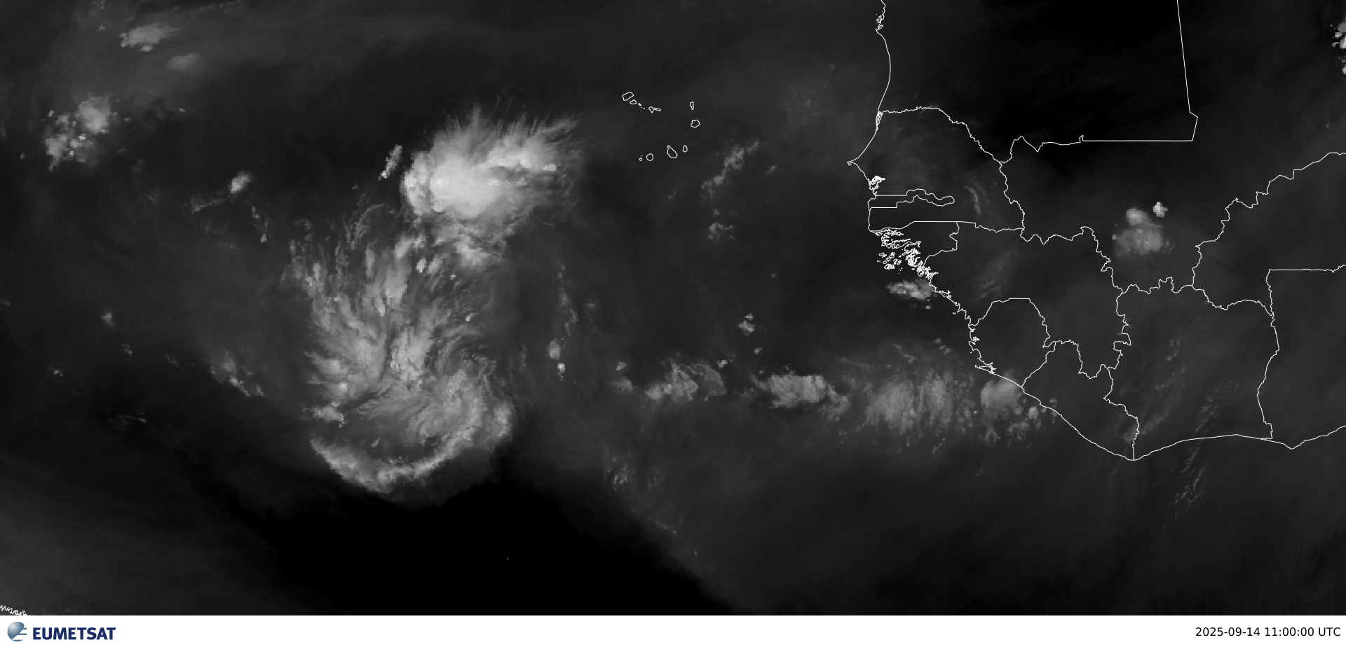
As I realized late yesterday, that wave that was forecast long ago that was supposed to come off Africa earlier today appears it didn't materialize... as there is limited moisture so far from WV and limited convection from IR...
The current low roughly presently near 31W though looks healther than I would have anticipated a day ago.
On METEOSAT-12 WV @ 11Z, I would put it near 6.50N, 31.25 W (Edit)
From the most recent scatterometer pass, HY-2B @ 07:59Z near 8.88 N, 30.81 W
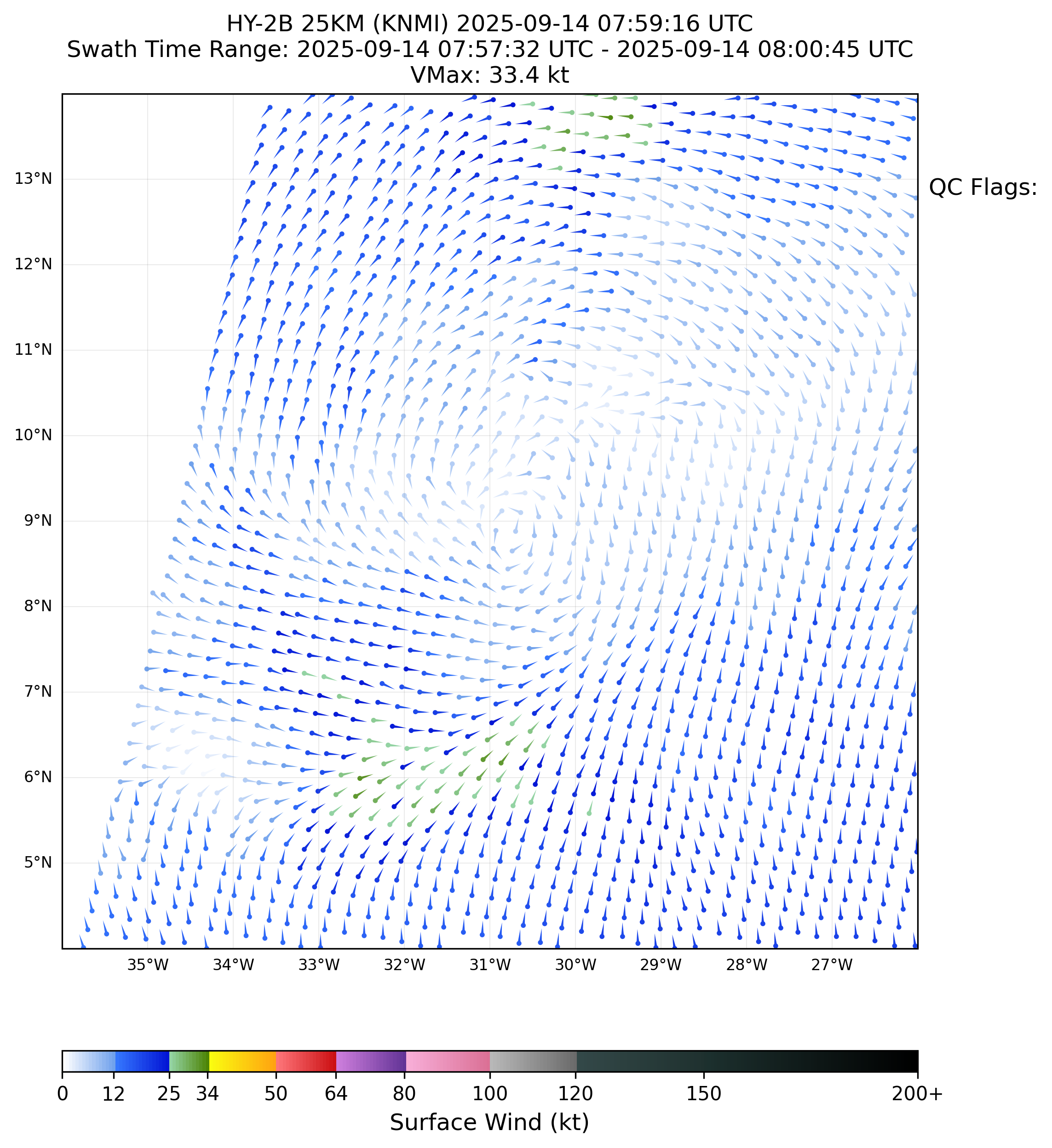
The scatterometer pass still shows a rather rough low as the circulation in the northern semi-circle appears rather weak still.
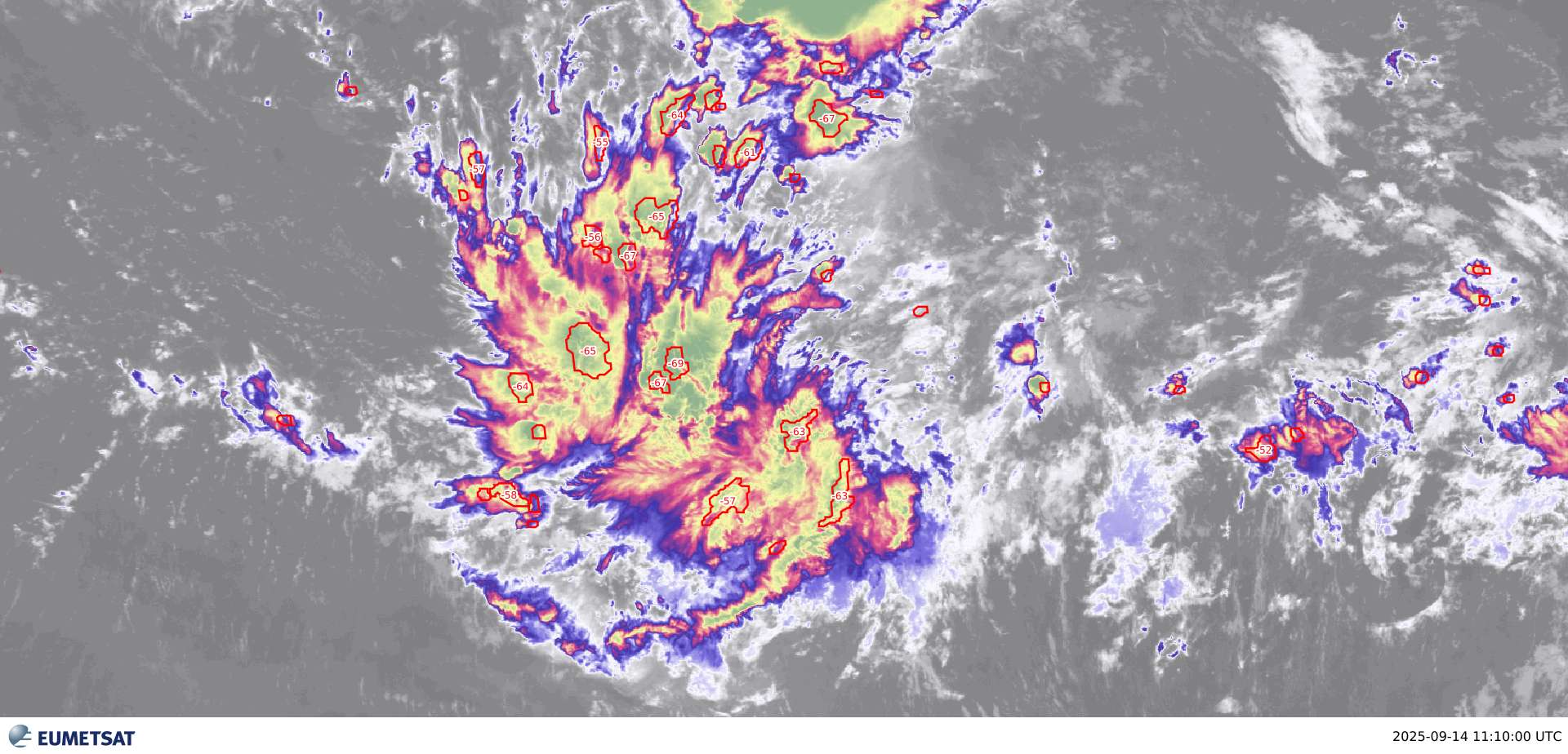
The current IR imagery shows broad convection, with cloud tops currently reaching -69 C
As far as moisture, the current outflow pattern is presently producing a conducive environment for the direction its heading..
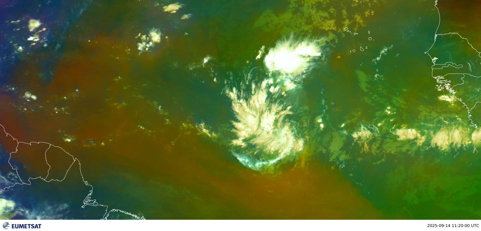
Plenty of moisture seen to the NW in the tropical airmass product from EUMETSAT:
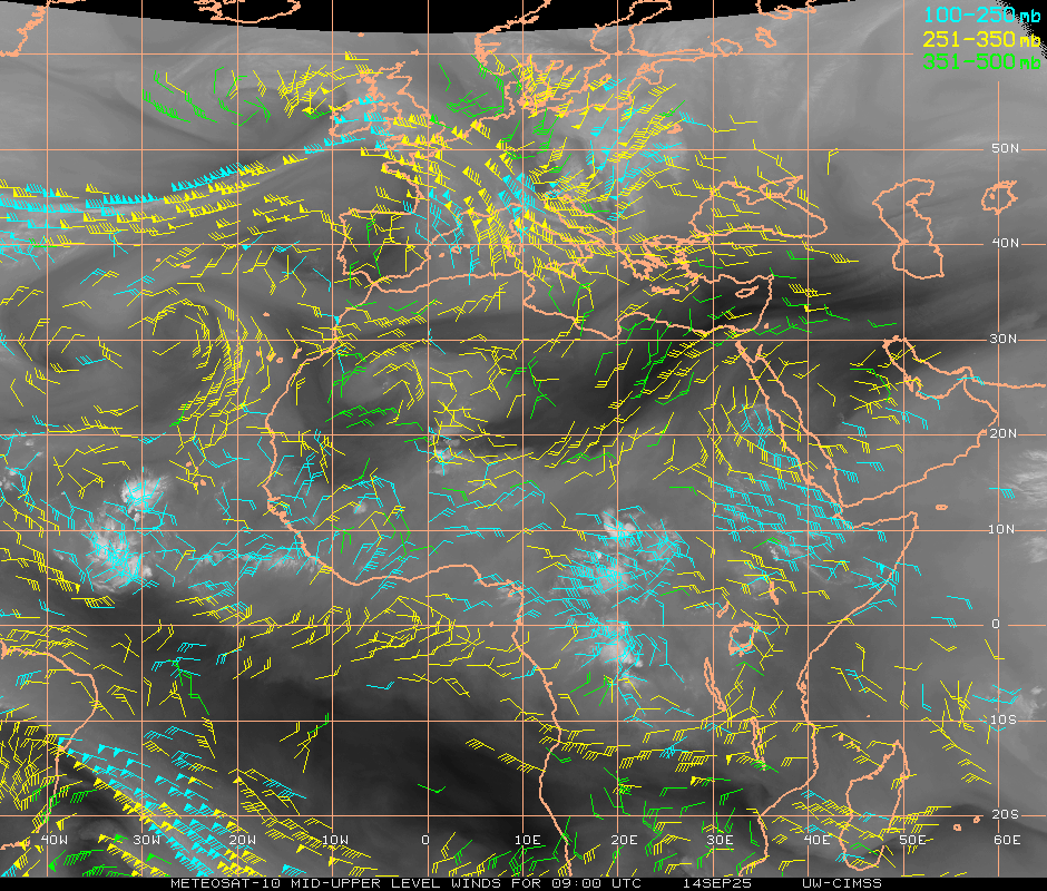
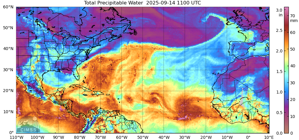
The moisture and spin is also evident in the CIMSS TPW product:
Vorticity analysis from CIRA appears to indicate its still broad and disorganized, with two centers of vorticity in the lower levels
With weaker, less broad circulation in the mid-level:
Looking at a few more dated images (over night) from the LPW product from CIRA agrees with the above vorticity analysis as there is clear spin developing from the lower levels up to 500 mb...
Notably there is some cyclonic circulation in the upper level also ..
But the divergence appears conducive:
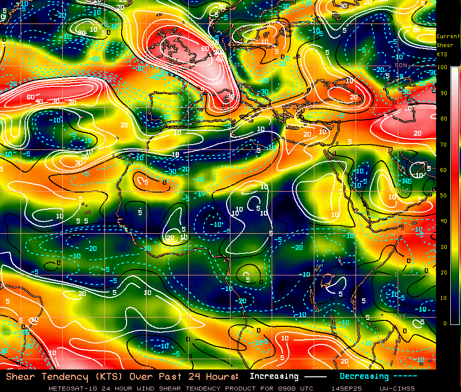
Deep-wind shear has been increasing north of the current surface low, and decreasing south of it as it continues to develop...
In the recent few weeks (especially 91L) dry air and a lack of moisture has been often to blame for some systems not developing (as mentioned in the outlook).
However given its current development pattern it seems to have produced a better environment than previous storms trying to develop here...
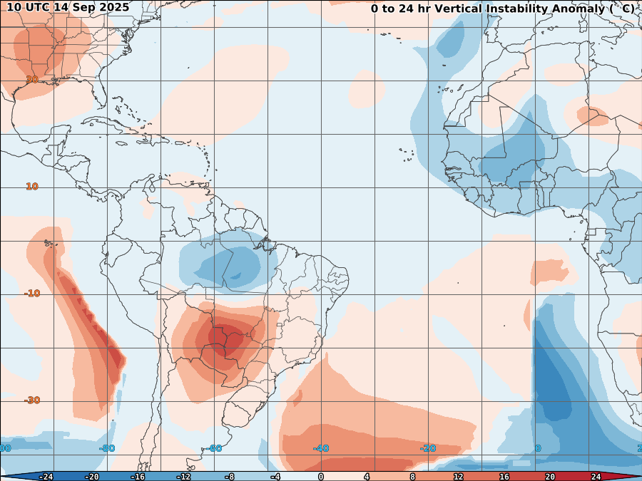
OSPO's vertical instability forecast from the TCFP product (which usess GFS) looks normal:
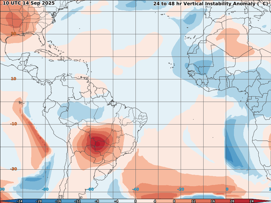
Edit (corrected): Over 24-48 hours it does slightly more unstable to the NW of where the system is headed ...
Overall, other than past issues this season with dry air and a lack of instability in the MDR there doesn't seem much to suggest the ensembles will get this wrong but it is still a bit early in its development...
06Z NHC outlook upgrades further to 30%/80%:
ABNT20 KNHC 150530
TWOAT

Tropical Weather Outlook
NWS National Hurricane Center Miami FL
200 AM EDT Mon Sep 15 2025

For the North Atlantic...Caribbean Sea and the Gulf of America:

Central Tropical Atlantic:
A tropical wave over the central tropical Atlantic is producing a
large area of disorganized showers and thunderstorms. Although dry
and stable air is expected to limit development during the next day
or so, gradual development is anticipated thereafter, and a tropical
depression is likely to form by the middle to latter part of this
week as the system moves west-northwestward at 10 to 15 mph over the
central tropical Atlantic.
* Formation chance through 48 hours...low...30 percent.
* Formation chance through 7 days...high...80 percent.

$$
Forecaster Jelsema
~~
Based only on the below and some disagreement between the deterministic models on timing/strength and some now apparent complexity of the genesis situation, I'm being a bit more conservative than the objective guidance from the probabilities in the 12,18Z ensembles in betting ...
~~ Long thread ( a bit dated ):
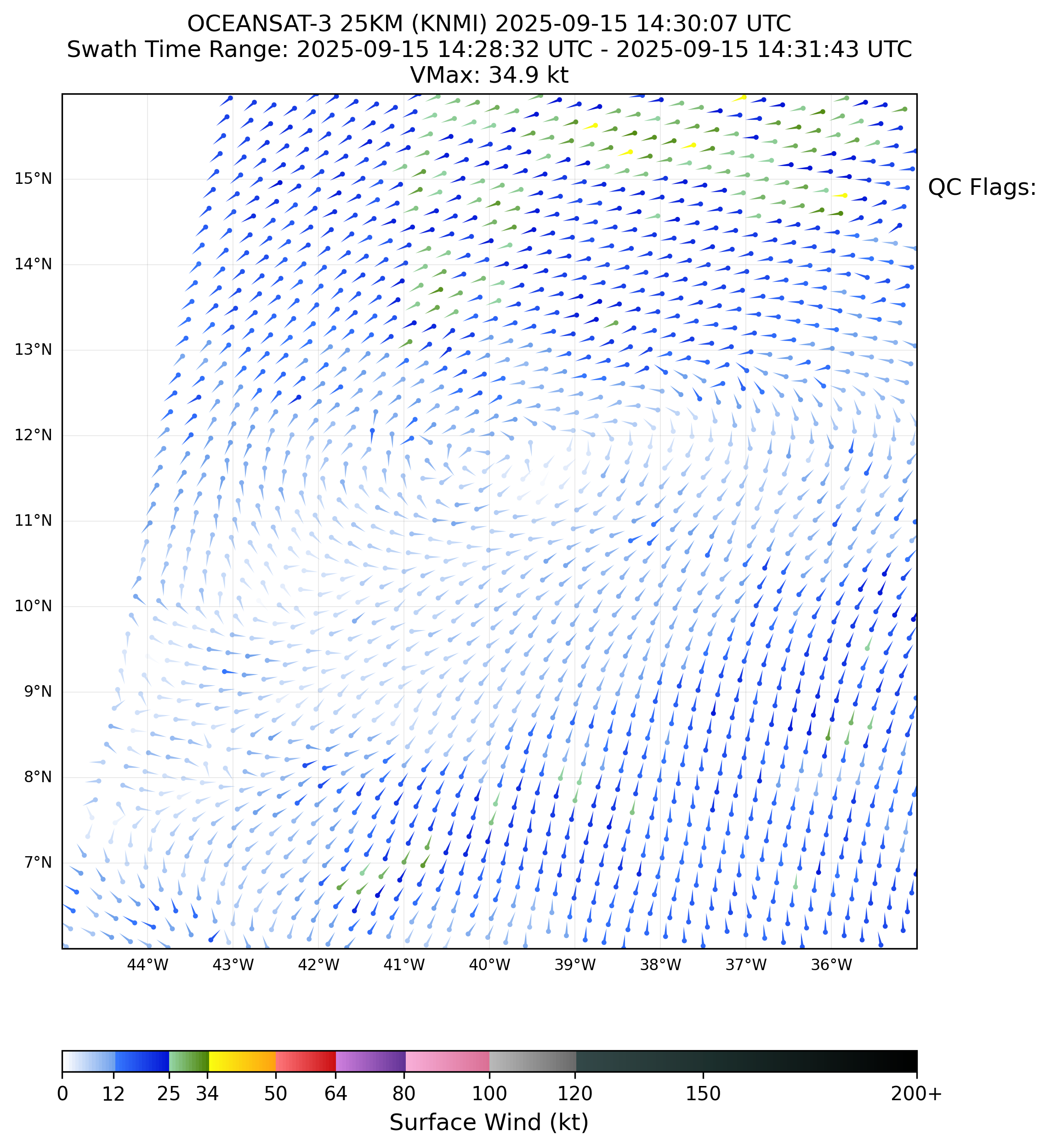
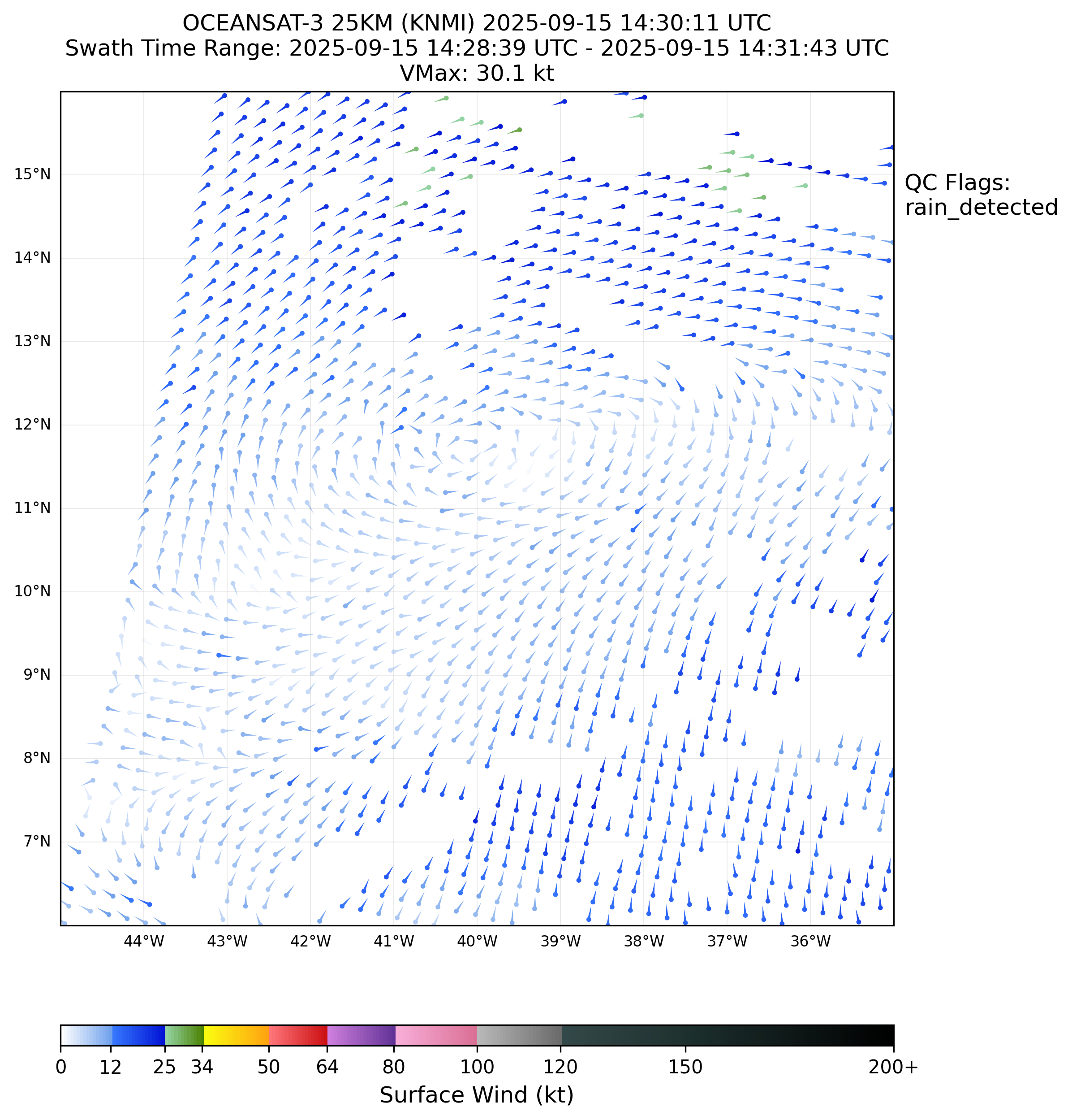
In the most recent scatterometer pass (Oceansat-3 @ 02:09Z) large parts are rainflagged, but it is somewhat apparent there is a rough surface circulation there. A very rough guess puts the center at 11.6 N, 36.3 W.
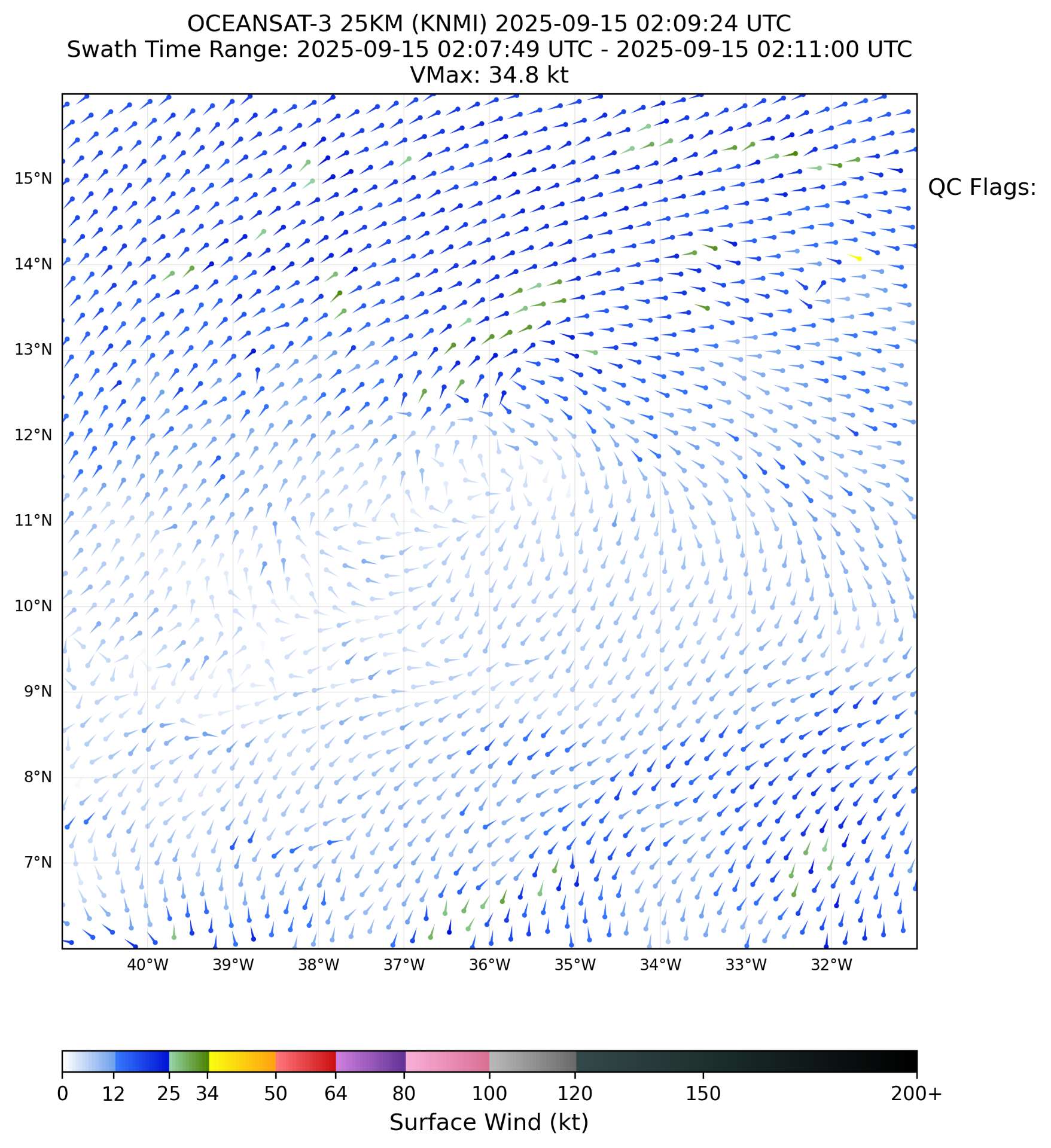
The favorable outflow pattern is gone and is now temporary less favorable, with less convection. The system appears generally less organized and elongated per CIRA's TPW product. This wasn't unexpected from the ensembles that it would need some more time to get organized but it looks fairly poor based on the somewhat dated and limited satellite imagery I reviewed from GOES & METOP-12 (~19Z - 01:30Z).
Relevant 500mb vorticity analysis from CIRA shows a pair of TUTTs north of the current disturbance.
~
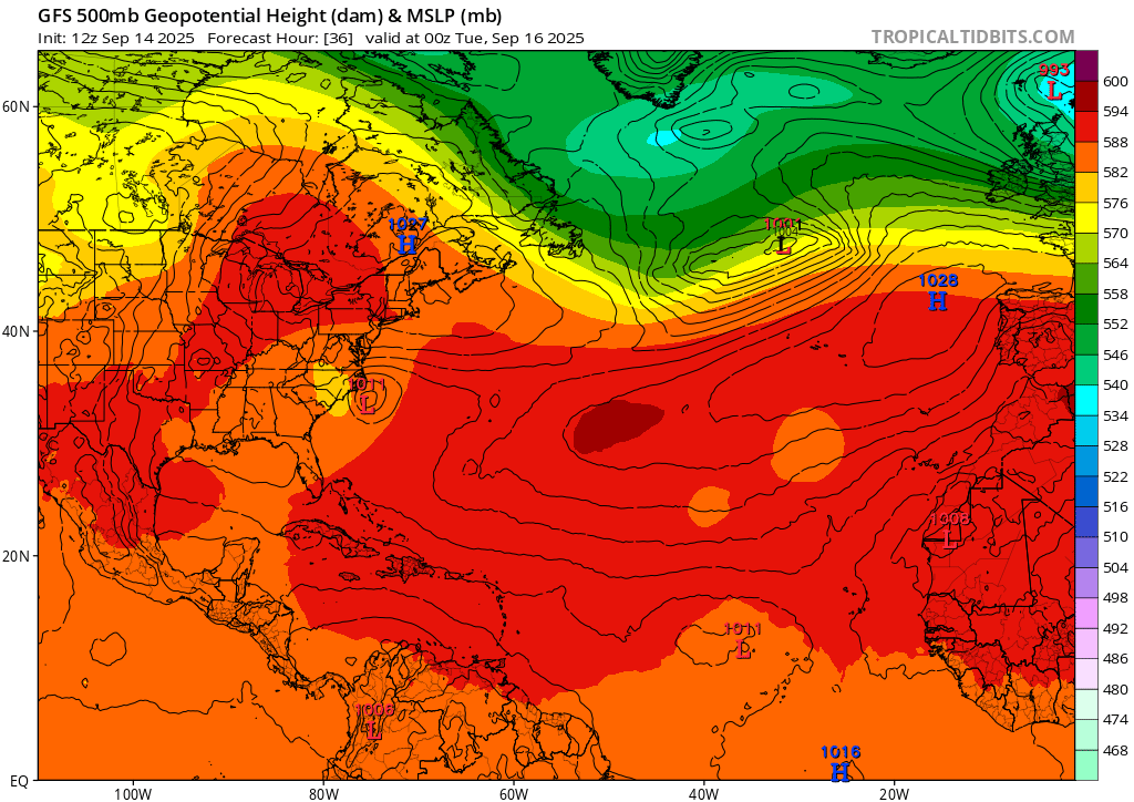
From the 0615Z NHC weather discussion, a "High pressure dominates the remainder of the discussion waters N of 20N, anchored by a 1029 mb high centered near 37N34W."
~
After looking at the 18Z deterministic GFS/ECMWF I will try to summarize what I can observe: it looks like the TUTT that is currently NNW (image above) of the disturbance will move southwest to interact more heavily with the disturbance near the 17-18th, resulting in an influx of dry air. The precise timing of how fast the lows move closer and their interaction together may limit the storm's chances for developing around then.
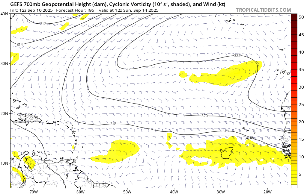
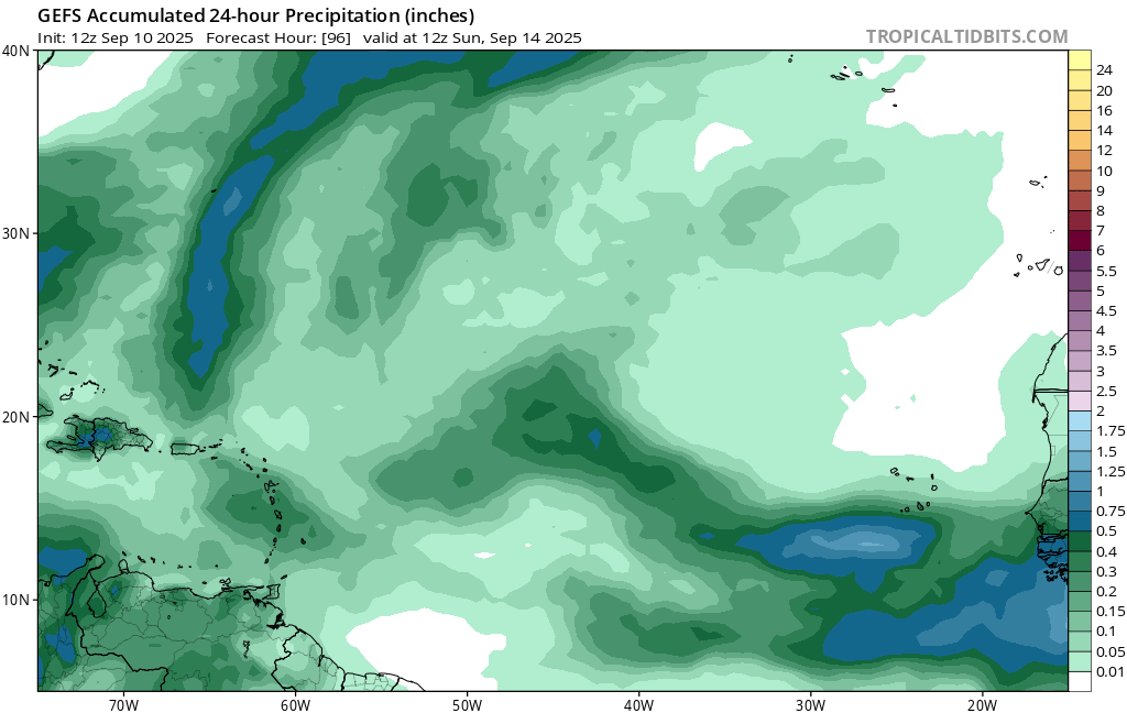
Relevant charts from already a bit dated 18Z GFS, ECMWF from tropicaltidbits:
Before the interaction with the TUTT, its forward speed itself looks like it might possibly be less favorable overall per Google 18Z (less time to organize before it interacts with the TUTT). Notably, Google 18Z has the disturbance moving faster west than the mean of the latest ensemble runs (12Z EPS/GEPS, 18Z GEFS/Google), and the same mean is moving faster than the 17/00Z ensemble run from yesterday; this resulted in the recurvature of the tracks that do develop happening similarly slightly further west. Overall, this is associated with slightly delayed development indicated in the probabilities I get.
A quick recheck from GOES with RAMMB/CIRA's SLIDER shows convection has picked up again for the present and looks a bit more organized.
Very good visualzation of the situation mentioned below (the TUTT about 15 deg N of the disturbance):
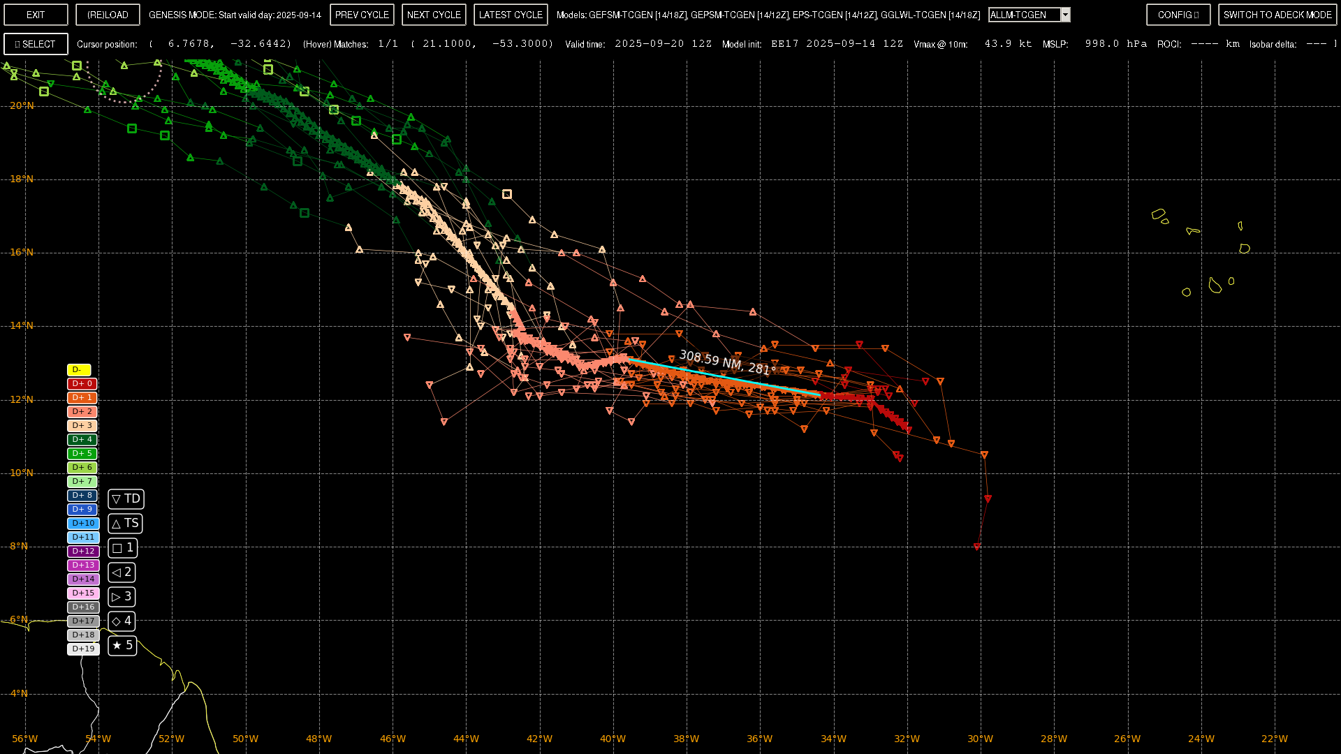
Going back to the scatterometer pass, subsetting the 12,18Z tracks on my rough estimate for the fix yields the following mean track for the next few days (a close-up), where with the limited 23 tracks (7,3,13 from GEFS, GEPS, EPS respectively; no google tracks with points for then): I observe there a change of direction indicated roughly around 06/19Z with a heading of about 320 degrees (with a heading prior to that of 280 degrees). The subsetted tracks hint the system will wobble a bit and slow down on the 16th before turning NW at a slower speed.
I don't know what happened here, there is suddenly no model support for anything?
I believe there are no previous years on record in the satellite era during which at least a tropical depression did not form in the Atlantic between September 1 - September 14, I had to go back to 1907 to find a year like that. But this could be a repeat of last year where MDR season was for some reason shifted much later than normal?
You are mistaken. Using my old climatology notebook and a reference period of 1991-2023 there was at least one year, 1992, where there was no storm between August 29-September 14.
# US Tropical/Subtropical Storm in records from North Atlantic basin: 1694
Years with NO Tropical/Subtropical Storms in North Atlantic basin from 8-29 to 9-14: 1992
Checked it with wikipedia's article:
In retrospect, south Florida was fortunate to have a respite after Andrew.
But based on that period, its statistically a ~5% chance of this happening now....
The det. models 7 days out (FSU) don't look kind.
From the ensembles though the chances are a bit higher (but still low) for the end of this week.
The biggest single day probabilities though in any of the ensembles happen though after the 14th... from a system forecast to come off the African coast around the 14th:
With the exception of GEFS 12Z which has some decent probability for the 14th, Google, EPS, and GEPS have backed off, anticipating any possible development until after the 14th (which is likely as of now)...
NHC has issued a TWO with 0%/20%, for the previously mentioned AEW forecast to come off now after the 12th...but only with chances to start development around the 14th (at least for GEFS)
CFS forecasts hint at later development though...