
Resolves in EDT
 1,000
1,000🏅 Top traders
| # | Trader | Total profit |
|---|---|---|
| 1 | Ṁ459 | |
| 2 | Ṁ440 | |
| 3 | Ṁ319 | |
| 4 | Ṁ171 | |
| 5 | Ṁ134 |
People are also trading
It's officially Helene now
Tropical Storm Helene Discussion Number 5
NWS National Hurricane Center Miami FL AL092024
1100 AM EDT Tue Sep 24 2024
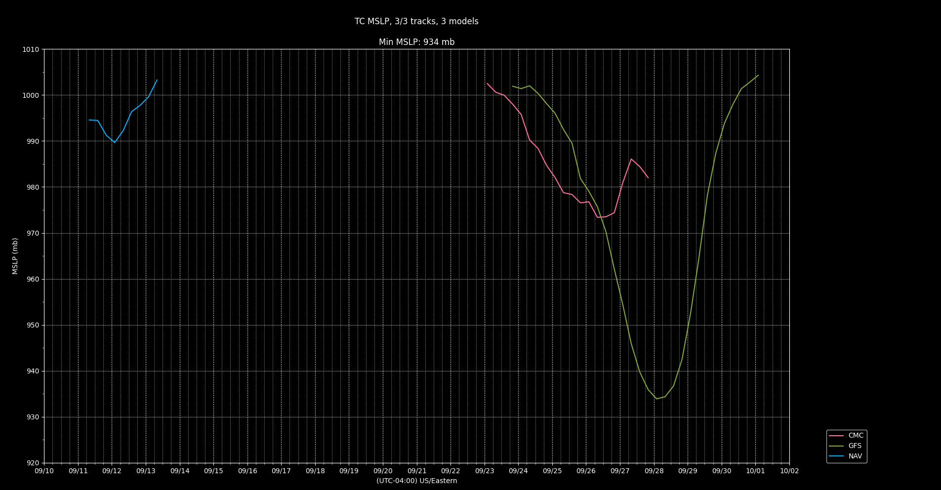
An Air Force Reserve Hurricane Hunter measured peak 925-mb
flight-level winds of 52 kt to the northeast of the center, which
supports an initial intensity of 40 kt. Dropsonde data also
indicated that the central pressure is down to 1000 mb. Very
recently, data from the plane and one-minute visible satellite
imagery indicate that the center has become better defined. Based
on these data, the system is being designated as Tropical Storm
Helene at this time.
State of Emergency declared for Florida before genesis for 41 counties...
@SaviorofPlant Also created a follow-up market for the next storm: https://manifold.markets/SaviorofPlant/when-will-a-tropical-or-subtropical-oq4mqie5sx?play=true
2. Northwestern Caribbean Sea and Gulf of Mexico:
Disorganized showers and thunderstorms located over the western
Caribbean Sea and portions of Central America are associated with a
very broad area of low pressure. Environmental conditions appear
favorable for gradual development of this system during the next
several days. A tropical depression is likely to form while the
system moves slowly northward across the northwestern Caribbean Sea
and Gulf of Mexico through the end of the week. Regardless of
development, this system is expected to produce heavy rains over
portions of Central America during the next several days.
* Formation chance through 48 hours...low...10 percent.
* Formation chance through 7 days...high...70 percent.8PM TWO increased the chances of a TC to 60% in 7 days for Northwestern Caribbean Sea and Southern Gulf of Mexico
There's a strong model signal for something in the Carribean somewhere between Sep 23 and Sep 26. The operational GFS forms it on Sep 23 (although it has genesis issues in this area sometimes due to incorrect handling of vorticity generated by the Venezuelan mountains; not sure if that's an issue here), while the operational Euro waits until the disturbance gets to the Gulf of Mexico and forms it on Sep 26.
@Calibrate I think the GFS is being too aggressive here, while the Euro is underdoing it.
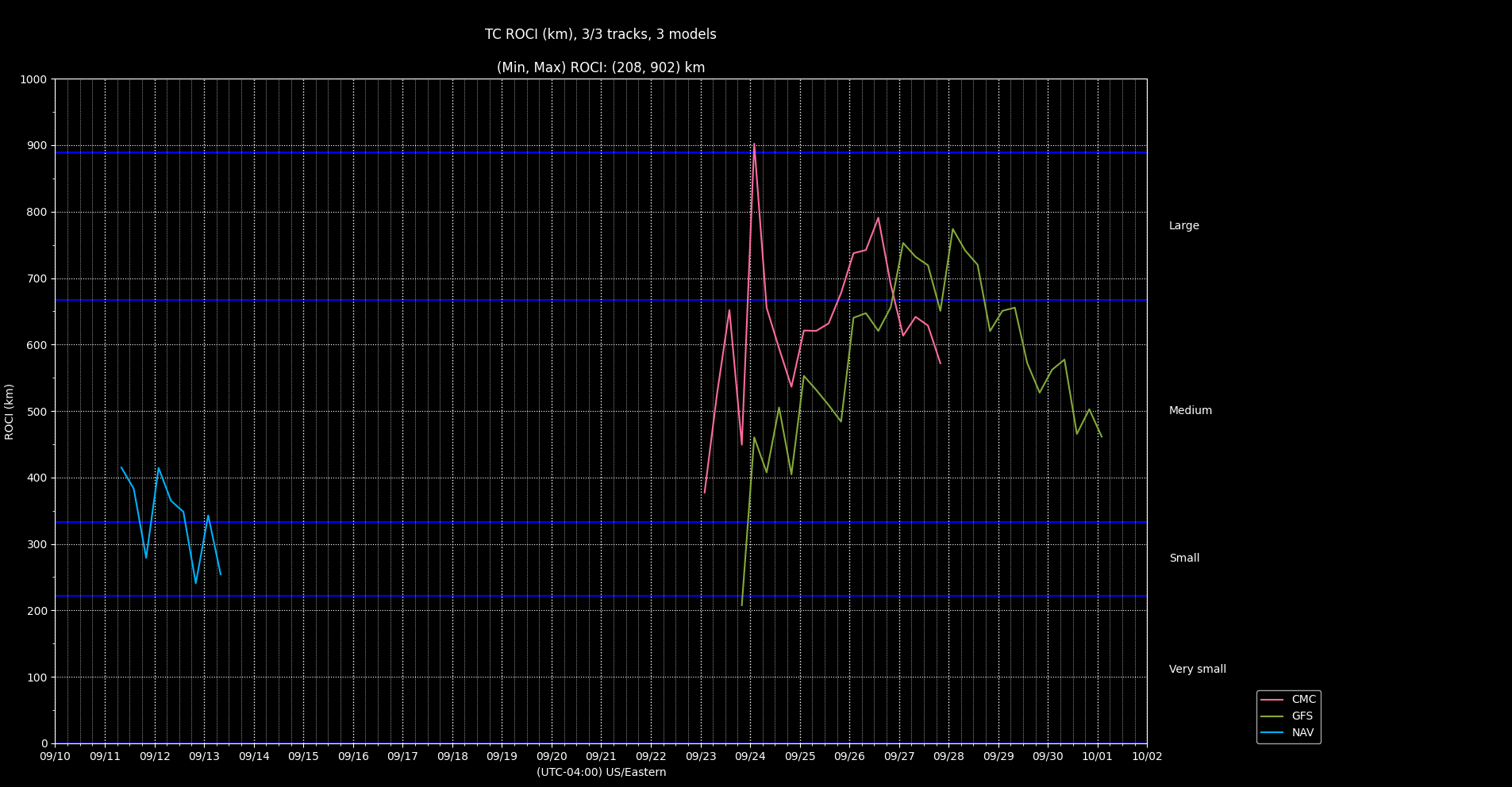
I'm not sure why the GFS insists on making this storm enormous
Too much contamination from the ensembles from my tracker crossing into the EP and back again to have much confidence... especially 7 days out..
Regarding the "size" , CMC has it even bigger according to my own analysis..
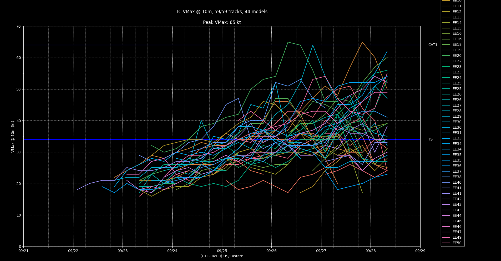
Deterministic 12/18Z (GFS 18Z, sorry about the time scale, NAVGEM/FNMOC ensembles have not had data for this last week while they do maintenance....). Pressure on GFS is something though.. Edit: Deterministic ECM not showing a TC but by the EPS members in the ensemble, they are showing also a strong TC signal but it is too far out though..
Edit: Latest advisory kept as a Potential Cyclone. NHC predicts early tomorrow for genesis (still at 80% for 48 hours):
The system has a high chance of being a tropical cyclone early
tomorrow, and some strengthening is possible before landfall as it
moves over warm waters with a conducive upper-level trough
interaction.  The official forecast is similar to the latest
decay-SHIPS model guidance and the prior forecast.
cyclonicwx.com header is helpful: "AFXXX 0208A CYCLONE is scheduled to depart in 1 hour and 3 minutes. "
Seems not enough time for a 11:59 pm update it seems to make it a TS before midnight, as I don't believe the appearance will dramatically change either in the next hour.
Final advisory for PTC 8; winds below TS, and low is either near the coast or inland.
https://www.nhc.noaa.gov/text/refresh/MIATCDAT3+shtml/162037.shtml
Potentially dumb question - what time zone is this in? I'm not sure when a storm is named, but if it can happen at, say, 1am Eastern, when the country is split between two days, which day does it resolve to?
@SaviorofPlant EST or EDT? All NHC advisories are in EDT, but the market description says EST, which is an hour behind.
AL95 is now Potential Tropical Cyclone Eight:
https://www.nhc.noaa.gov/text/refresh/MIATCPAT3+shtml/152056.shtml
https://www.nhc.noaa.gov/text/refresh/MIATCDAT3+shtml/152058.shtml
Maximum sustained winds are near 45 mph (75 km/h) with higher gusts.
Some strengthening is possible before the system makes landfall.
* Formation chance through 48 hours...high...70 percent.
* Formation chance through 7 days...high...70 percent.
INIT 15/2100Z 32.0N 78.0W 40 KT 45 MPH...POTENTIAL TROP CYCLONE
12H 16/0600Z 32.4N 78.7W 40 KT 45 MPH...TROPICAL CYCLONE
24H 16/1800Z 33.1N 79.4W 45 KT 50 MPH...INLAND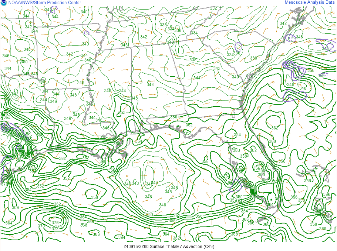
(Theta-e, advection from SPC)
If anyone besides @SaviorofPlant also expects it to be free of the front by 11 PM (and become a named storm by then), I've increased my bet otherwise to the 16th.
There are 4 hours left now until the next full advisory (11PM EDT).
Waiting for TWO on 2pm.... Edit: rotation disappeared very quickly from radar...
Has a very short amount of time left to organize to make it into a TC today...
Edit: Not sure about the probabilities I've hedged on, as there is no deep convection visible on satellite imagery and high wind shear forecast (40kt) ...
If TWO doesn't increase the 48 hour probabilities to 60-70%, I'll buy more Other again...
I've been watching that area for a related market for the last couple days. I'm not sure I'd give it 20% even....
I put climatologically (1991-2013) cumulative base rate for 12th-19th (excluding 11th since we already will have Gordon very likely) at 79% for one storm, 46 % for two... Base rate will probably be in between that since I can't completely disregard Gordon, so taking 63% as the average of those two and a pure guess of 20-30% (25% average) based on the TWO TC genesis probabilities of a TS (they don't go out far enough for this question), gives me about 44% of a TS by the 20th.
@parhizj Models were pretty confident in formation yesterday, but they're significantly less bullish on it now. There's something projected in the subtropics to the east of it now, but I'm not sure if that system is even subtropical and I forget how to read the soundings to check...
Edit: Number of scattered potential disturbances makes thing complicated but excluding Gordon's tracks from 12Z ensembles, I still get roughly the same probabilities.