
Resolves based on operational intensity, not post-season adjustments
🏅 Top traders
| # | Trader | Total profit |
|---|---|---|
| 1 | Ṁ687 | |
| 2 | Ṁ219 |
@SaviorofPlant Ileana is done....
"...ILEANA BECOMES A REMNANT LOW... ...THIS IS THE LAST ADVISORY..."
https://www.nhc.noaa.gov/text/refresh/MIATCDEP4+shtml/151440.shtml
Latest advisory keeps it at 40 kt
The latest satellite and radar
imagery suggests the center is just east of the latest burst of
convection south of Cabo San Lucas, and this is in reasonable
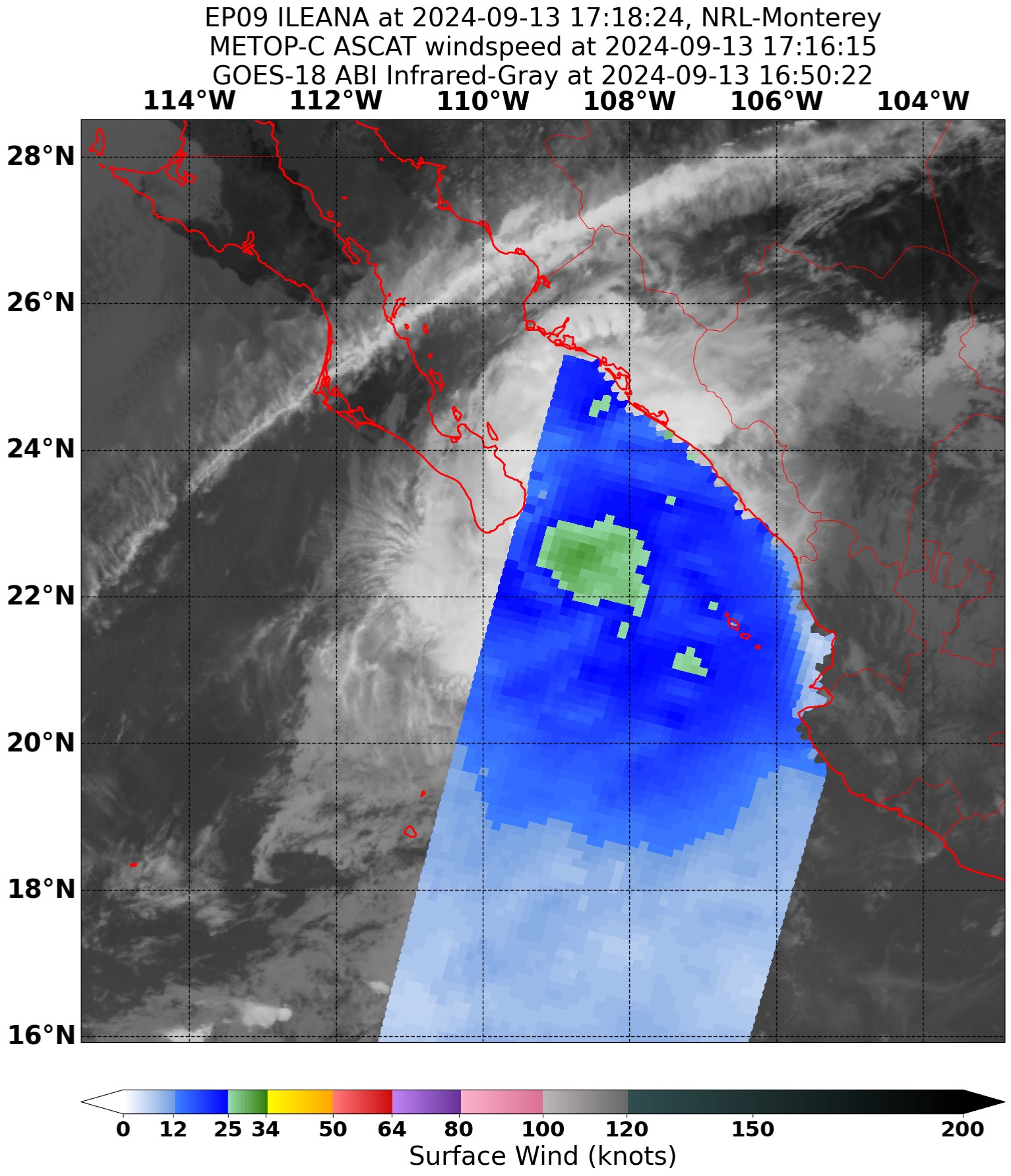
agreement with positions from recently received ASCAT data.  The
scatterometer passes show 30-35 kt winds to the east of the center,
and based on this and the possibility of undersampling, the initial
intensity is held at a possibly generous 40 kt.
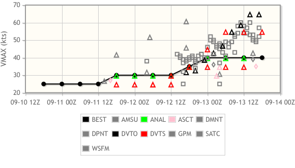
Something not mentioned is that there was quite a bit of spread in the guidance, especially from the Dvorak analyses, which might suggest why they’re being generous… given it was a CDO scene from the DVTO this makes sense to me (as a hobbyist), given radar plus ASCAT would be more authoritative sources of inference in this situation. Should note SATCON also had it at 50 kt ( only 2 members)
ASCAT pass: (NRL)
Fixes (HFIP)
Eyeballing it and forgetting to look at radar led me to some suboptimal bets upward earlier…
Some impressive wide area deep convection from satellite imagery earlier has raised the chances of 50 kt in the 5am advisory ... This might be the last chance for it to be officially reported above 45kt ...
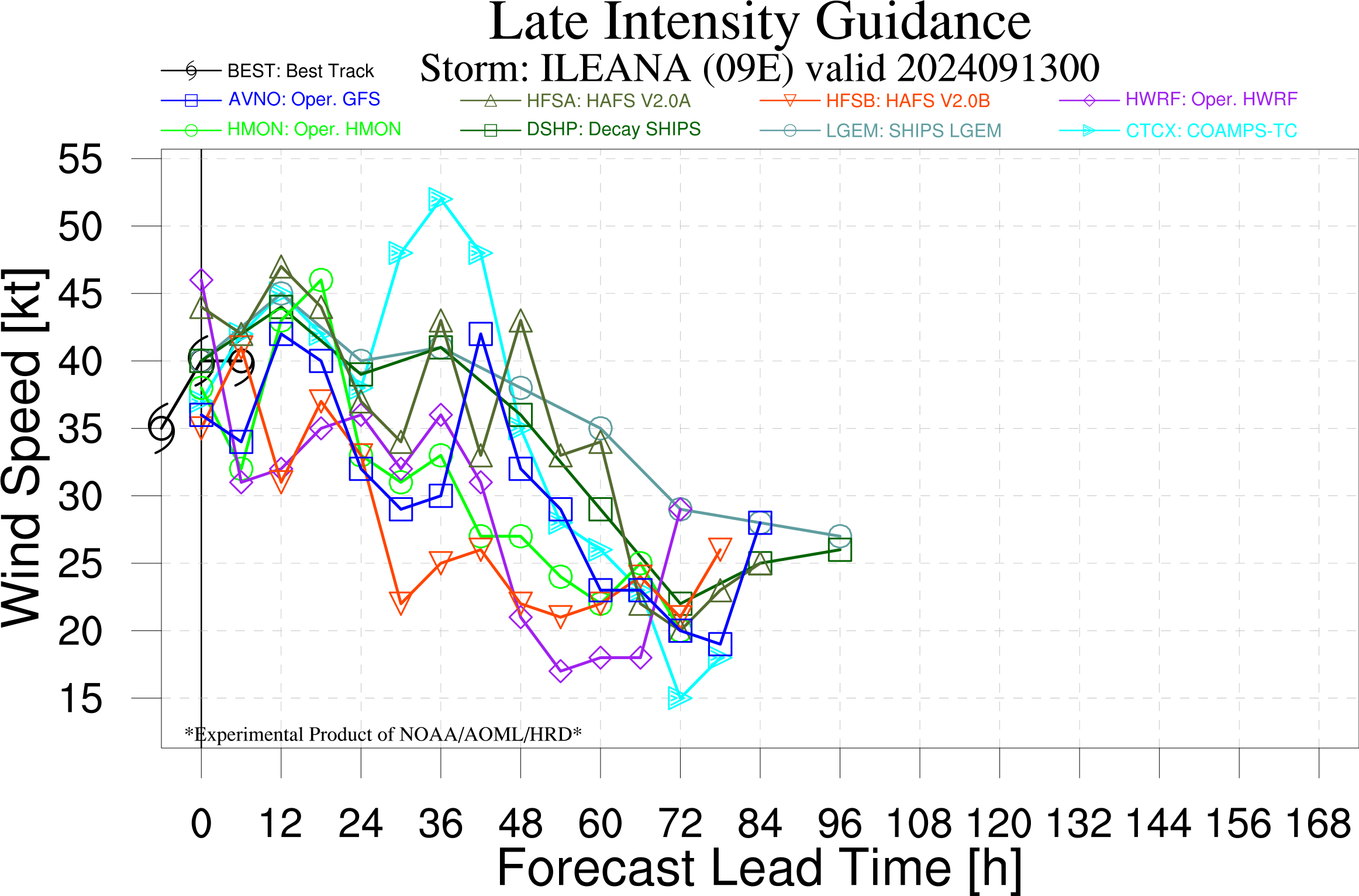
HFIP fixes:
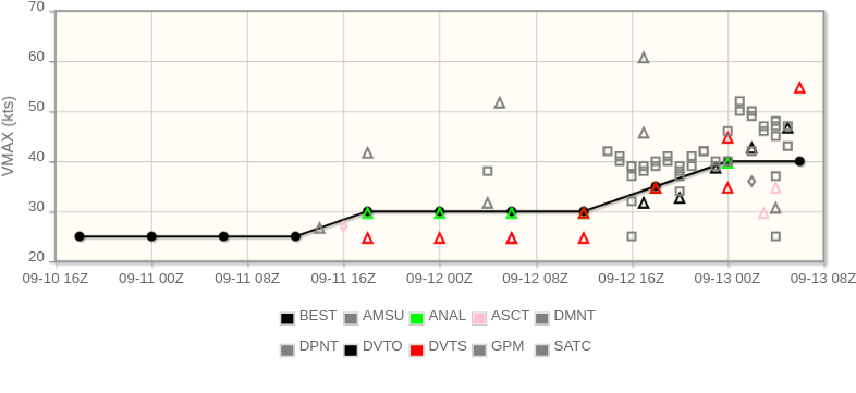
The objective ADT from OSPO and CIMSS are both supporting 50kt. The subjective Dvorak for OSPO though kept it at 2.5, TAFB has it at 3.5. MCTSW (SSD) puts it in the 45kt bucket. From DPRINT it appears to show a weakening trend (although it still supports 50 kt), either 50 or 45kt seems reasonable, but I've not bet up 45 beyond 50, based on my previous analysis, that the satellite IR imagery does appear to show less strength than a few hours ago (the convection did pause or lessen for a while), and that some computer data (tcvitals/com files for models) for 06Z still has it at 40kt.
Kept at 40 kt. Relevant discussion from NHC:
Recent satellite imagery shows that Ileana is producing a large
convective canopy with clouds top temperatures as cold as -80C.
However, data from the Mexican radar at Cabo San Lucas shows that
the convective banding under the canopy is poorly organized and
suggests that the circulation center is still broad and elongated.
The various satellite intensity estimates are little changed since
the previous advisory, so the initial intensity remains 40 kt.Now a TS, from NHC discussion, https://www.nhc.noaa.gov/text/refresh/MIATCDEP4+shtml/122038.shtml?
Ileana is currently located within an environment of warm ocean
waters, moderate vertical wind shear, and within a fairly moist low-
to mid-level troposphere.  However, very dry air is evident on water
vapor imagery to the northwest of the cyclone.  These conditions are
unlikely to change before the cyclone reaches Baja California Sur on
Friday, and the NHC forecast shows some strengthening before then.
Land interaction with the peninsula should cause some weakening.
When the center reaches the Gulf of California, the sea surface
temperatures are quite warm.  While some restrengthening is possible
after the cyclone emerges back over water, Ileana will encounter
increasing westerly wind shear and drier air by hour 48, so it won't
have much time to restrengthen.  After that time, weakening is
expected as Ileana's convection is sheared off, and the cyclone is
forecast to become a remnant low in about 72 h.  It should be noted
that the GFS and ECMWF simulated satellite imagery show the cyclone
becoming a remnant low a bit earlier around hour 60.  Although the
cyclone will likely dissipate prior to 96 h, a 96 h point is carried
as a remnant low for continuity.@SaviorofPlant ,I think you meant the weak TS category to be 34-49 kt? Edit: Given that NHC only reports intensities in 5 kt bins, what do you think about in the future doing that for the market bins, i.e. 0-30kt, 35-45 kt, 50-60kt, etc instead of 34-49.
Now a TD. Expected to stay a weak TS.
https://www.nhc.noaa.gov/text/refresh/MIATCMEP4+shtml/121530.shtml
Relevant discussion from NHC:
Tropical Depression Nine-E is currently located within an
environment of warm ocean waters, low to moderate vertical wind
shear, and within a fairly moist low- to mid-level troposphere.
However, very dry air is evident on water vapor imagery to the
northwest of the cyclone.  These conditions are unlikely to change
before the cyclone reaches Baja California Sur, and the NHC
forecast shows the system becoming a tropical storm later today.
Land interaction with the peninsula should cause some temporary
weakening.  However, water temperatures in the Gulf of California
are quite warm, so some restrengthening is possible after the
cyclone emerges back over water.  The NHC intensity forecast is
near the higher end of the intensity guidance.  Beyond 60 h,
westerly wind shear is expected to increase while the cyclone moves
into a drier environment.  Even if the system is still over water
at that time, the cyclone is likely to begin weakening.  The GFS
and ECMWF simulated satellite imagery products show the cyclone
losing its convection around 72 h.  The NHC forecast shows
weakening at that time, with the system becoming a remnant low
beyond 72 h.
======
Old analysis (11 am advisory is out now), mostly agrees with the forecast:
Going by the genesis tracker data from 00Z global ensembles mostly (06Z GEFS), estimated CDF by member counts below (models weighted equally).
Notably most of the models keep it a small storm, but some of the FNMOC 00Z ensemble members blows up the size.
EPS already thinks its a TC:
CDF for ALL-TCGEN, Earliest VMax @ 10m >= 0 kt:
09/13: 73.38%
CDF for ALL-TCGEN, Earliest VMax @ 10m >= 34 kt:
09/15: 66.36%
This is not that the peak intensity will fall in the range but just that we will get an intensity within this range from a member, sometime:
CDF for ALL-TCGEN, 34 <= Earliest VMax @ 10m <= 49 kt:
09/15: 66.36%
CDF for ALL-TCGEN, 50 <= Earliest VMax @ 10m <= 63 kt:
09/14: 10.43%
Only a couple FNMOC members show a Cat 1:
CDF for ALL-TCGEN, 64 <= Earliest VMax @ 10m <= 82 kt:
09/13: 2.27%
None of the 128 members show a Cat 2 or higher.
Converting these CDF ensemble counts to the bins (not normalized), now that it is a TD:
~ 7% stays a TD
~ 56% a weak TS
~ 8% a strong TS
~ 2% a cat 1 (or higher)
Normalizing (* 100/73):
~ 10% stays a TD
~ 77% a weak TS
~ 11% a strong TS
~ 3% Cat 1 (from a pair of FNMOC members)
From the a-deck: of the (early) regional models, only 1/4 show a strong TS, other 3 are weak. NNIC shows a TD. Most of the global deterministic from 12Z show a TD, the exception being AVNI.
====
Haven't been able to look at OHC from CIRA as its too early. Referencing AOML's THCP it looks pretty low despite high SSTs (depth of 26C isotherm is about 50m for the cone -- about the minimum needed for a TC to strengthen/ (https://www.aoml.noaa.gov/hrd/tcfaq/A15.html)).
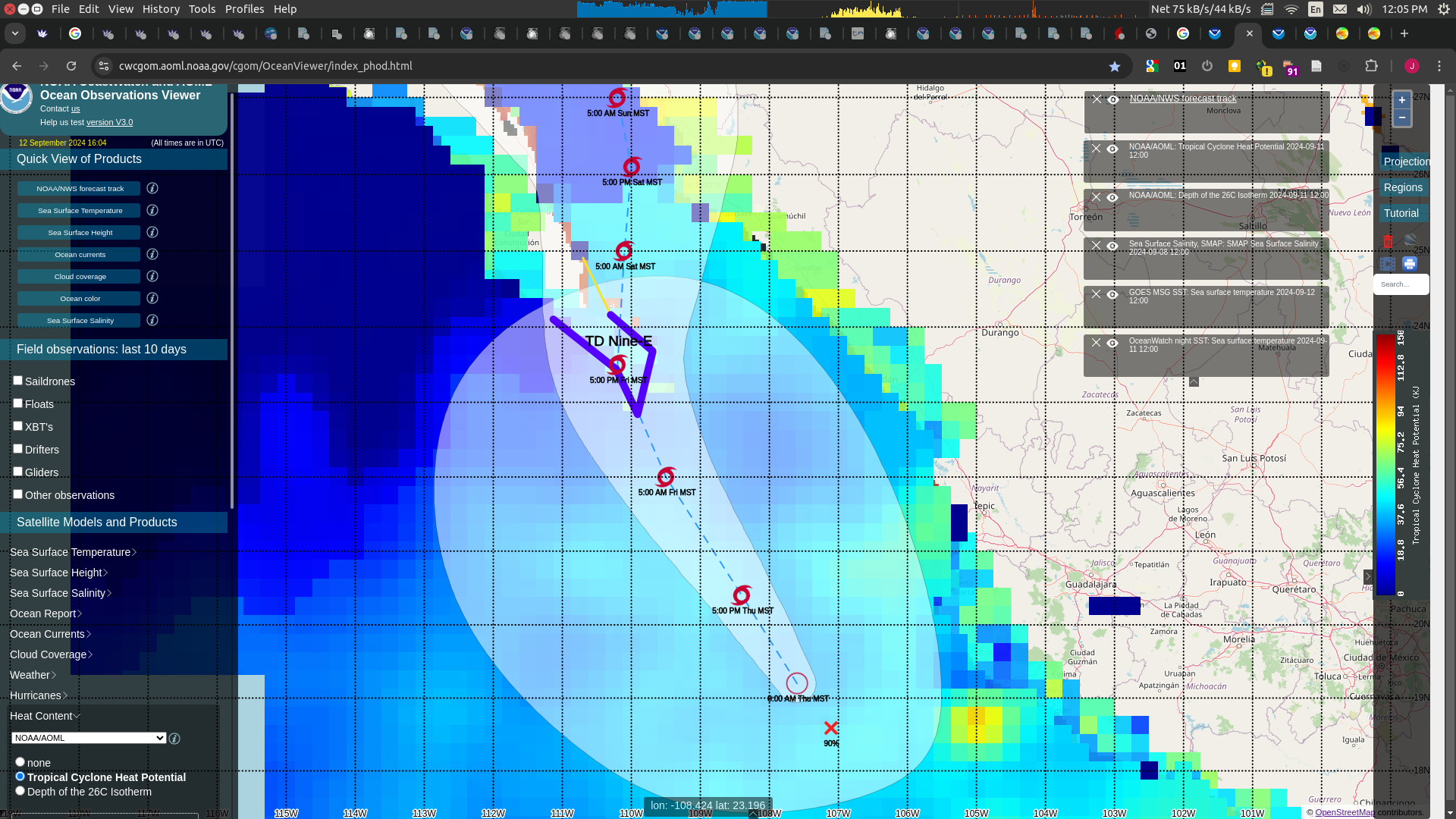
Based on advisory error notebook, putting the chances of (high end) >= TS upwards of 80%, a Cat 1 (12%), Cat 2 (3%), Cat 3-5 (0-1%); with a hurricane at ~ 19%.
So, taking the average of these this error estimate for TD and Cat1 as for the TD I'll put the TD bin at 15%, hurricane at 11% (cat1: 7%, cat 2: 2%, cat3-5 0-1%).
Rest is ad hoc normalization:
This leaves leaving a TS with 100-15-11 = 74%. Referencing the super ensemble (77%, 11%) to normalize yields 65% and 9%. Given the closeness of the NHC peak intensity though to the middle of the two TS bins (45 kt forecast) and the narrowness of the bins, this seems too aggressive a split when the intensity estimates themselves are only accurate to ~10 kt. With some naive simulation, 30-40% based on the advisory it will end up in the strong TS bin (assuming a std error of either 5 or 10 kt around the peak 45kt intensity). This suggests a 65%, 35% split between the weak, strong bins might at least apriori be reasonable.
Taking the average of these two (the super ensemble and the simulation):
For the super ensemble TS bins (weak, strong) normalized within the bin
0.77 / (0.77 + 0.11) = 0.875
0.11 / (0.77 + 0.11) = 0.125
Then computing the normed percents for the bins:
0.74 * ((0.875 + 0.65) / 2) ~= 56% (weak TS)
0.74 * ((0.125 + 0.35) / 2) ~= 18% (strong TS)
Recapping:
15% | TD
56% | Weak TS
18% | Strong TS
7% | Cat 1
2% | Cat 2
2% | Cat3-5 (guessing ~1%, <1%, <1%)
Intensity wise this is what I get without considering track errors (if it heads west instead of making landfall in Mexico); about 5 of the FNMOC members ( out of 128 in the super ensemble) do show a more westerly track (outside the normal distribution of tracks); one of these is a cat 1. There is not enough of these large track error scenarios to estimate the intensity wise uncertainty well but I'd estimate its less than the intensity NHC advisory error for Cat2-5 (~ < 5%); (takes too much mana to bet those down to that amount).