
What will be the maximum intensity of Tropical Storm Joyce?
7
Ṁ1kṀ6.9kresolved Oct 1
100%93%
Weak tropical storm (35 - 45 kt)
1.4%
Strong tropical storm (50 - 60 kt)
2%
Category 1 hurricane
1.4%
Category 2 hurricane
1.2%
Category 3 hurricane
0.6%
Category 4 hurricane
0.6%
Category 5 hurricane
Operational intensity, post-season adjustments do not matter for resolution purposes
This question is managed and resolved by Manifold.
Market context
Get  1,000 to start trading!
1,000🏅 Top traders
| # | Trader | Total profit |
|---|---|---|
| 1 | Ṁ605 | |
| 2 | Ṁ133 | |
| 3 | Ṁ35 | |
| 4 | Ṁ29 | |
| 5 | Ṁ8 |
People are also trading
Sort by:
@ChristopherRandles Yeah... no special updates and nothing higher than 45 kt on best track:
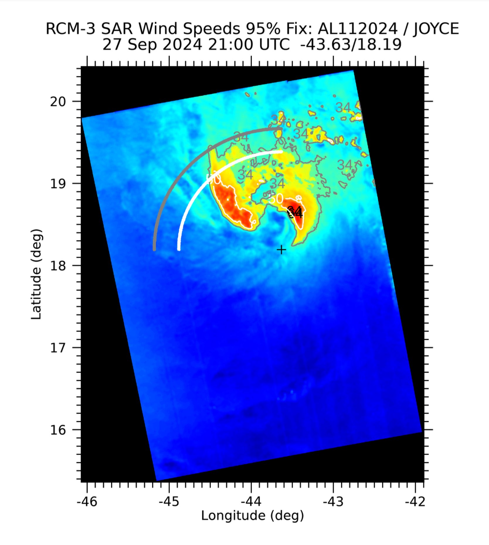
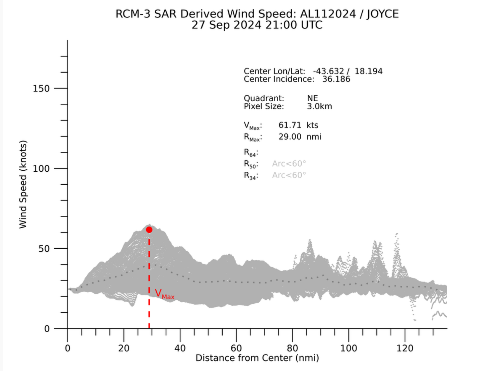
Given that it’s not forecast to strengthen and there looks to be more shear in its future, subjective Dvorak estimates it seems will help to continue to lowball the storm strength IMO… at least this SAR data supports 50 kt or higher.. (AMSU and most objective also support 50 or higher) but as they kept it at 45 due in part to an ASCAT pass it doesn’t seem we will be lucky enough to get another lucky ASCAT pass in the next 24 h when it may likely weaken…
@SaviorofPlant you want to rethink that 1%? Still has not reached 50 kt yet and not forecast to presently…
I’ll wait…
Recent microwave imagery, including an 0022 UTC ASCAT-B pass,
indicates that Joyce's circulation is tilted with height, with a
mid-level center feature displaced about 40 nm north of the
low-level center.  The scatterometer data also indicated that Joyce
still has maximum winds of 45 kt, which is also supported by the
latest TAFB and SAB Dvorak fixes.

Joyce is moving toward the west-northwest (300/10 kt) to the south
of a narrow subtropical ridge.  Deep-layer troughing is forecast to
amplify over the central Atlantic during the next few days, eroding
the ridge and causing Joyce to gradually turn toward the northwest
and north and slow down to a crawl by this time on Monday.  Because
several of the regional hurricane models appear to keep Joyce too
strong in the coming days (more on that below) and show recurvature
with acceleration, the NHC track forecast more closely follows the
global models and is a blend of the previous forecast with the GFEX
consensus.

UW-CIMSS analyses and SHIPS diagnostics indicate that Joyce is
being affected by moderate-to-strong southerly shear, which is
reflected by the satellite presentation.  This shear is not
expected to abate during the next few days, and the storm will also
be moving into a gradually drier and subsident environment.
Therefore, the NHC intensity forecast calls for little change in
strength during the next 24 hours, followed by gradual weakening
thereafter.  Joyce is likely to lose its organized convection
and become a remnant low by day 3, if not sooner.  The remnant low
should degenerate into a trough by day 4 or 5 and will likely be
absorbed by a larger weather system moving across the eastern
Atlantic.