
Resolves according to operational intensity
 1,000
1,000🏅 Top traders
| # | Trader | Total profit |
|---|---|---|
| 1 | Ṁ329 | |
| 2 | Ṁ197 | |
| 3 | Ṁ33 |
@SaviorofPlant Rafael is post tropical now, final advisory:
https://www.nhc.noaa.gov/text/refresh/MIATCDAT3+shtml/102032.shtml
Post-Tropical Cyclone Rafael Discussion Number 30
NWS National Hurricane Center Miami FL AL182024
300 PM CST Sun Nov 10 2024
The limited convection that Rafael was producing in its eastern
semicircle has collapsed. Surface observations, visible satellite
images, and a 1530z ASCAT-C pass show the surface circulation has
become poorly defined and very elongated in the north-south
direction. Since Rafael does not possess a well-defined center or
organized convection, it no longer meets the definition of a
tropical cyclone. This will be the final NHC advisory on Rafael.
Hurricane Rafael makes landfall in Cuba as a Category 3 storm, causing power system to collapse
https://www.cnn.com/2024/11/06/weather/hurricane-rafael-path-forecast-climate
@DistinctlySkeptical They’ve had enough problems this year that there is a Wikipedia page on it:
https://en.wikipedia.org/wiki/2024_Cuba_blackouts
I don’t think anyone is surprised by the blackout, but the cat. 3 storm was surprising.
I know the NHC advisory has been consistent in having it weaken eventually but the forecast is as stated of low confidence due to uncertainty over its eventual track.
EPS has been for days largely predicting a more westerly track in the GoM and some of the regional models now favor that (going even SW towards Mexico) and in such a scenario as it is further out in the future the uncertainty in intensity also increases, so it’s too early I think to call the peak intensity for the storm, even though the environment looks to be very poor for the most part in the GoM to support a cat 4.
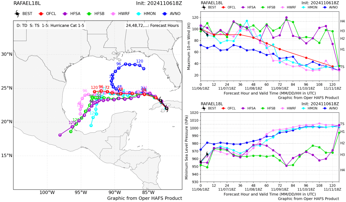
At 70 kt.. latest advisory predicting intensification to cat 2 before landfall in Cuba
With lack of time/energy, defaulted back to advisory error & peeking at SHIPS/AI-RI
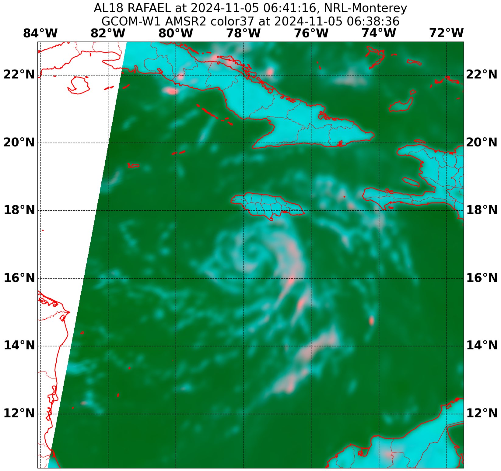
Hurricane Rafael Tropical Cyclone Update
NWS National Hurricane Center Miami FL       AL182024
720 PM EST Tue Nov 05 2024

...RAFAEL INTENSIFIES INTO A HURRICANE...

Recent data from a NOAA Hurricane Hunter aircraft indicates that
Rafael has become a hurricane with maximum sustained winds of 75
mph (120 km/h) with higher gusts. Data from the aircraft also
indicates that the minimum central pressure has fallen to 986 mb
(29.11 inches).

SUMMARY OF 720 PM EST...0020 UTC...INFORMATION
---------------------------------------------------
LOCATION...19.4N 79.9W
ABOUT 20 MI...35 KM SE OF LITTLE CAYMAN
ABOUT 305 MI...495 KM SSE OF HAVANA CUBA
MAXIMUM SUSTAINED WINDS...75 MPH...120 KM/H
PRESENT MOVEMENT...NW OR 325 DEGREES AT 15 MPH...24 KM/H
MINIMUM CENTRAL PRESSURE...986 MB...29.11 INCHES

$$
Forecaster Papin/HagenUsed average of three different sets of probabilities (advisory error notebook, EPS/12Z members pruned by pressure, and probs derived from best of each regional model runs (since a TD) -- inversely weighted by RMSE for MSLP then manually assigned probs by vmax&mslp charts); the inclusion of the best 4 regional model run probs only include TS/CAT1/CAT2 as possibilities so it creates a much more aggressive prediction (less spread).
For future reference (cat-5 to high end ts probs):
(probs are cat-5 to ts, with % from advisory, eps12Z-pressure, and best-atcf-regional-weighted)
(1 + 0 + 0) / 3 = 0.3%
(4.1 + 8.4 + 0) / 3 = 4.2%
(10.2 + 16.8 + 0) / 3 = 9%
(25.5 + 19.4 + 18) / 3 = 21%
(43.9 + 47.1 + 80) / 3 = 57%
(15.7 + 8.4 + 2) / 3 = 8.7%
final probs (cat-5 to ts):
[0.3, 4.2, 9, 21, 57, 8.7]
edit: on second thought..
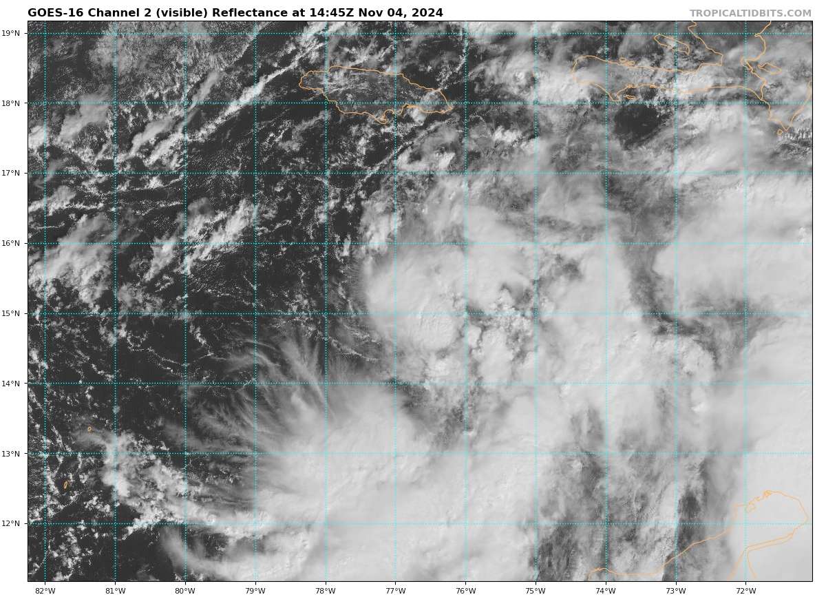
000
WTNT43 KNHC 041440
TCDAT3

Tropical Depression Eighteen Discussion Number   4
NWS National Hurricane Center Miami FL       AL182024
1000 AM EST Mon Nov 04 2024

Data from the Air Force Hurricane Hunters, satellite images, and
surface observations indicate that the low pressure system over the
south-central Caribbean Sea has developed a well-defined center and
is producing organized deep convection. Therefore, the system now
meets the criteria of a tropical depression. The maximum
flight-level winds from the aircraft support holding the initial
wind speed steady at 30 kt. Deep convection is gradually organizing
near the center and in bands around it, especially on the south and
east sides of the circulation.

The depression has jogged a bit to the right of the previous track,
and the initial motion estimate is now 010/8 kt. A turn to the
northwest is expected later today, and that motion is forecast to
continue during the next few days as a ridge builds over the
southwestern Atlantic and northeastern Caribbean. This motion should
take the center of the system near Jamaica tonight, near or over the
Cayman Islands by late Tuesday, and across western Cuba on
Wednesday. After that time, when the system reaches the Gulf of
Mexico, the model solutions diverge, which appears to be due to
differences in the steering patterns and vertical depth of the
storm. The NHC track forecast is largely an update of the previous
one and remains close to the various consensus models.  However, it
should be noted that the track forecast over the Gulf of Mexico is
of low confidence.

The environmental factors of low wind shear, high moisture, and warm
SSTs support intensification, and since the system now has a well
organized circulation, there is increasing confidence of steady
strengthening until the system reaches Cuba or the southeastern Gulf
of Mexico. In 3 or 4 days, when the system reaches the central Gulf,
a sharp increase in southwesterly vertical wind shear, drier air,
and slightly cooler waters should end the strengthening trend and
induce weakening. The NHC intensity forecast lies near the middle of
the guidance envelope, fairly close to the HCCA and IVCN consensus
aids.


Key Messages:

1. Hurricane conditions are expected in the Cayman Islands on
Tuesday and are possible in portions of Cuba early Wednesday, where
Hurricane Warnings and Watches are in effect. There is a risk of
dangerous impacts from hurricane-force winds and storm surge in the
Cayman Islands and portions of western Cuba. Tropical storm
conditions are expected in Jamaica this evening.

2. Interests in the Florida Keys should closely monitor this system
as tropical storm watches could be required for portions of these
areas later today.

3. The system is forecast to enter the Gulf of Mexico later this
week, but given significant uncertainties in the long-range forecast
track and intensity, it is too soon to determine what, if any,
impacts could occur. Residents in this area should regularly monitor
updates to the forecast.

4. The system will bring areas of heavy rain across portions of the
western Caribbean, including Jamaica and portions of Cuba through
mid-week. Flooding and mudslides are possible in these areas.  Heavy
rainfall will spread north into Florida and adjacent areas of the
Southeast United States mid to late week.


FORECAST POSITIONS AND MAX WINDS

INIT  04/1500Z 15.2N  76.9W   30 KT  35 MPH
 12H  05/0000Z 16.5N  77.6W   35 KT  40 MPH
 24H  05/1200Z 18.2N  79.0W   45 KT  50 MPH
 36H  06/0000Z 19.9N  80.7W   60 KT  70 MPH
 48H  06/1200Z 21.7N  82.4W   70 KT  80 MPH
 60H  07/0000Z 23.4N  83.9W   70 KT  80 MPH
 72H  07/1200Z 24.6N  85.1W   70 KT  80 MPH
 96H  08/1200Z 26.1N  87.4W   65 KT  75 MPH
120H  09/1200Z 27.4N  89.5W   55 KT  65 MPH

$$
Forecaster Cangialosi/Kelly