Resolves according to NHC advisories
This market is only open for 2.5 days and then closes
 1,000
1,000🏅 Top traders
| # | Trader | Total profit |
|---|---|---|
| 1 | Ṁ382 | |
| 2 | Ṁ162 | |
| 3 | Ṁ42 | |
| 4 | Ṁ9 |
Now a cat.2 ..
WTNT24 KNHC 011452
TCMAT4

HURRICANE IMELDA FORECAST/ADVISORY NUMBER  20
NWS NATIONAL HURRICANE CENTER MIAMI FL       AL092025
1500 UTC WED OCT 01 2025

HURRICANE CENTER LOCATED NEAR 31.0N  70.4W AT 01/1500Z
POSITION ACCURATE WITHIN  20 NM

PRESENT MOVEMENT TOWARD THE EAST-NORTHEAST OR  65 DEGREES AT  17 KT

ESTIMATED MINIMUM CENTRAL PRESSURE  966 MB
EYE DIAMETER  25 NM
MAX SUSTAINED WINDS  85 KT WITH GUSTS TO 105 KT.
64 KT....... 30NE  40SE  50SW  40NW.
50 KT....... 60NE  70SE  70SW  80NW.
34 KT.......150NE 200SE 120SW 160NW.
4 M SEAS....210NE 330SE 330SW 300NW.
WINDS AND SEAS VARY GREATLY IN EACH QUADRANT.  RADII IN NAUTICAL
MILES ARE THE LARGEST RADII EXPECTED ANYWHERE IN THAT QUADRANT.

REPEAT...CENTER LOCATED NEAR 31.0N  70.4W AT 01/1500Z
AT 01/1200Z CENTER WAS LOCATED NEAR 30.7N  71.3W

FORECAST VALID 02/0000Z 31.9N  66.7W
MAX WIND  90 KT...GUSTS 110 KT.
64 KT... 35NE  40SE  50SW  50NW.
50 KT... 80NE  90SE  90SW  90NW.
34 KT...220NE 210SE 140SW 240NW.

FORECAST VALID 02/1200Z 32.6N  61.5W...POST-TROP/EXTRATROP
MAX WIND  85 KT...GUSTS 105 KT.
64 KT... 40NE  40SE  50SW  50NW.
50 KT... 90NE  90SE  90SW  90NW.
34 KT...260NE 220SE 170SW 250NW.Looks like they've capped it at 85 kt as they are disregarding the higher wind speeds present as part of the baroclinic strengthening for Imelda ... I know in the later advisory they mention that the GFS model doesn't show an outlier solution any more with respect to track, but may want to wait a couple days after final advisory in case Imelda's remnants does something really weird....
Hurricane Imelda Discussion Number  22
NWS National Hurricane Center Miami FL       AL092025
1100 PM AST Wed Oct 01 2025

Data from the Air Force Reserve reconnaissance aircraft this evening
found that Imelda is likely in the early to mid stages of
extratropical transition. In addition to the aircraft crossing a
baroclinic zone just to the north of the hurricane's core, the winds
have become very asymmetric, with hurricane-force winds around the
western and southeastern sides of the circulation, but much lighter
winds to the northeast. The aircraft also found rising pressure
between fixes, and the earlier eyewall reported from the prior
mission has been reduced to a small fragment on the northwestern
side. Despite the degraded presentation, the 700 mb flight-level
winds were a little higher than the prior mission, peaking at 98 kt
in the southeastern quadrant. While this would normally translate to
a somewhat higher 90 kt maximum sustained wind, these flight-level
winds occurred where Imelda has little in the way of precipitation
according to the Bermuda radar. Thus, the initial intensity will
remain 85 kt for this advisory, using a slightly lower surface wind
reduction.For reference, I ended up referencing mainly Google/18Z, 12Z (ended up preferring 18Z) for the high end probs (cat 4-5 probs), but I did look at the EPS/12Z cat.1 and cat 2 probs which were not far off, as well as this handy implied error NHC forecast error chart from CIRA for sanity checking the previous (I do go a bit beyond what it implies), and for it remaining a TS I referenced all of the above... (google 18Z had a bit higher chance like EPS/12Z of it remaining a TS in the ~10% range)
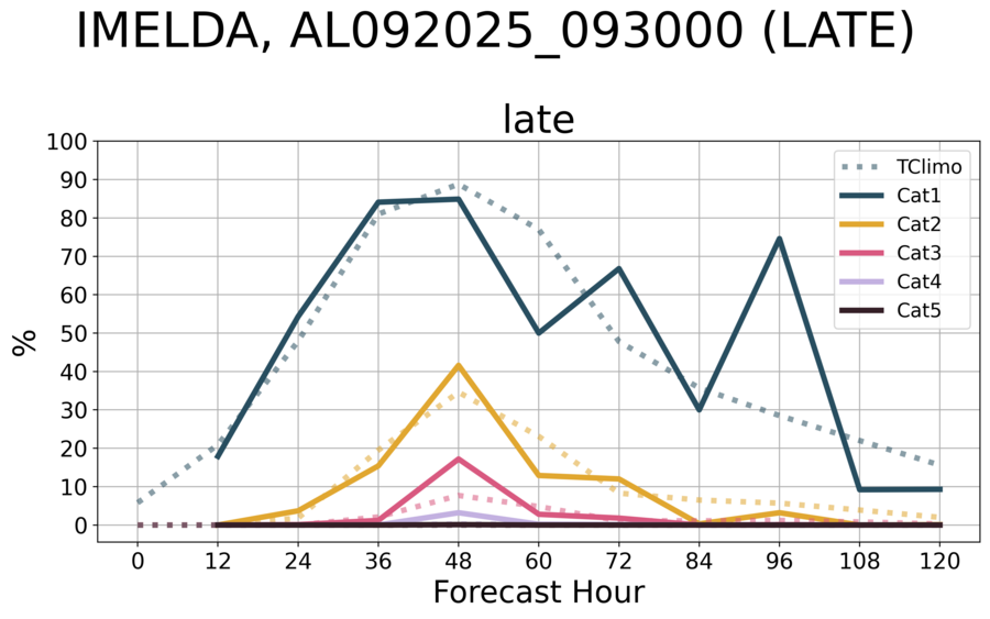
RI chances seem generally low, but there are a few outliers among a very few EPS/Google members that show there is perhaps some small probability of it becoming a major hurricane.
I did look at all the satellite wind data products and there is a decent amount of spread in the satellite wind data estimates for the last several hours or so... (from 50-74 kt (SAR from 29/23Z)).
The mean track from a super ensemble showed about 20 kt of strengthening over the next couple days, while Google/18Z also showed about the same (from 30/00Z to 02/00Z).
Depending on some lower chance the current strength of the storm is being slightly under estimated (especially from the wind shear affecting estimates), a major doesn't seem completely impossible.
~