closes early after 3 days, resolves based on NHC operational advisories
 1,000
1,000🏅 Top traders
| # | Trader | Total profit |
|---|---|---|
| 1 | Ṁ893 | |
| 2 | Ṁ797 | |
| 3 | Ṁ137 | |
| 4 | Ṁ130 | |
| 5 | Ṁ51 |
@SaviorofPlant You did a good job buying it when it was still cheap! I was a lot more conservative until near close.
@parhizj As soon as I saw sub-900 HAFS runs I set a couple cat 5 limit orders, I've only ever seen those when there's a solid chance of an extremely favorable environment. Ended up selling some of those cheap Cat 5 shares later on but held just enough to edge you out in profit...
@SaviorofPlant I'm just glad nobody else noticed first, because my initial bets on this market were very bad...

This market has closed, but I have opened another one with less liquidity predicting the minimum central pressure, if anyone wants to live trade on this all the way through the end:
https://manifold.markets/SaviorofPlant/what-will-be-the-minimum-central-pr-qh50QIO6cg?r=U2F2aW9yb2ZQbGFudA
~ 4 more hours to market close.
Google/06Z should come out soon (20-50) mins.
~
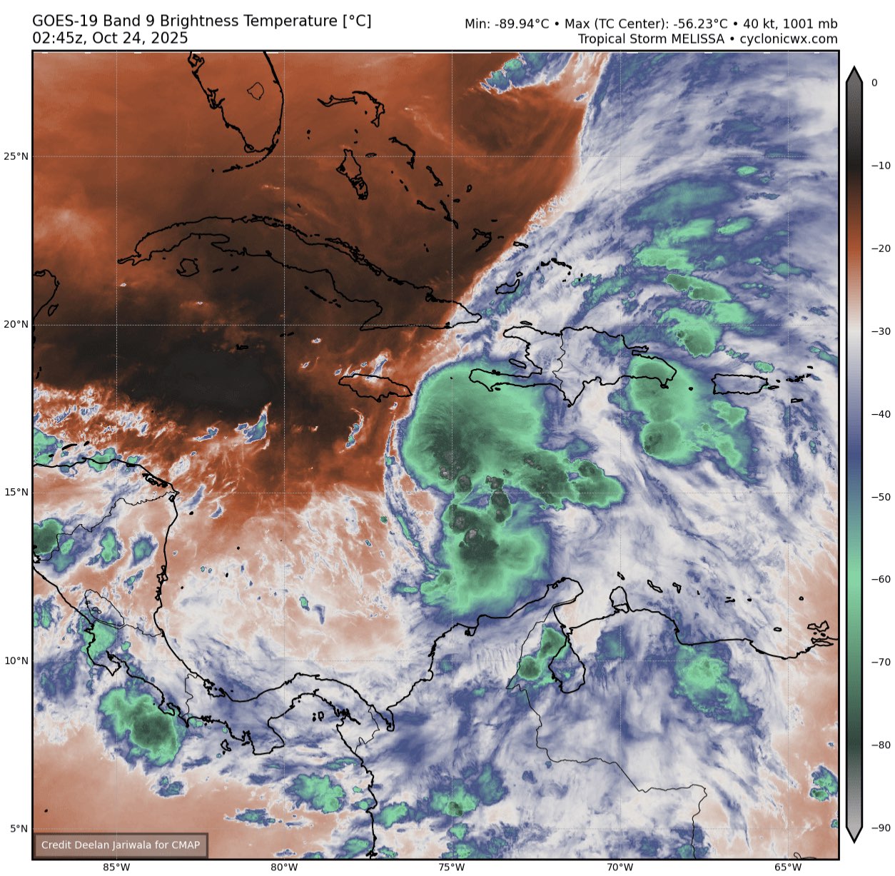
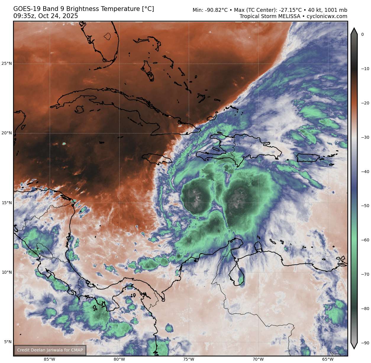
Last partial scatterometer pass from 3-4 hours ago shows the surface circulation where it is expected (a guess at a fix it at roughly 15.73, -75.74 but it looks like the center could be a bit west off the swath) -- doesn't look elongated to the east but we don't have the western half of the circulation, and notably the deep convection pattern did change since then.
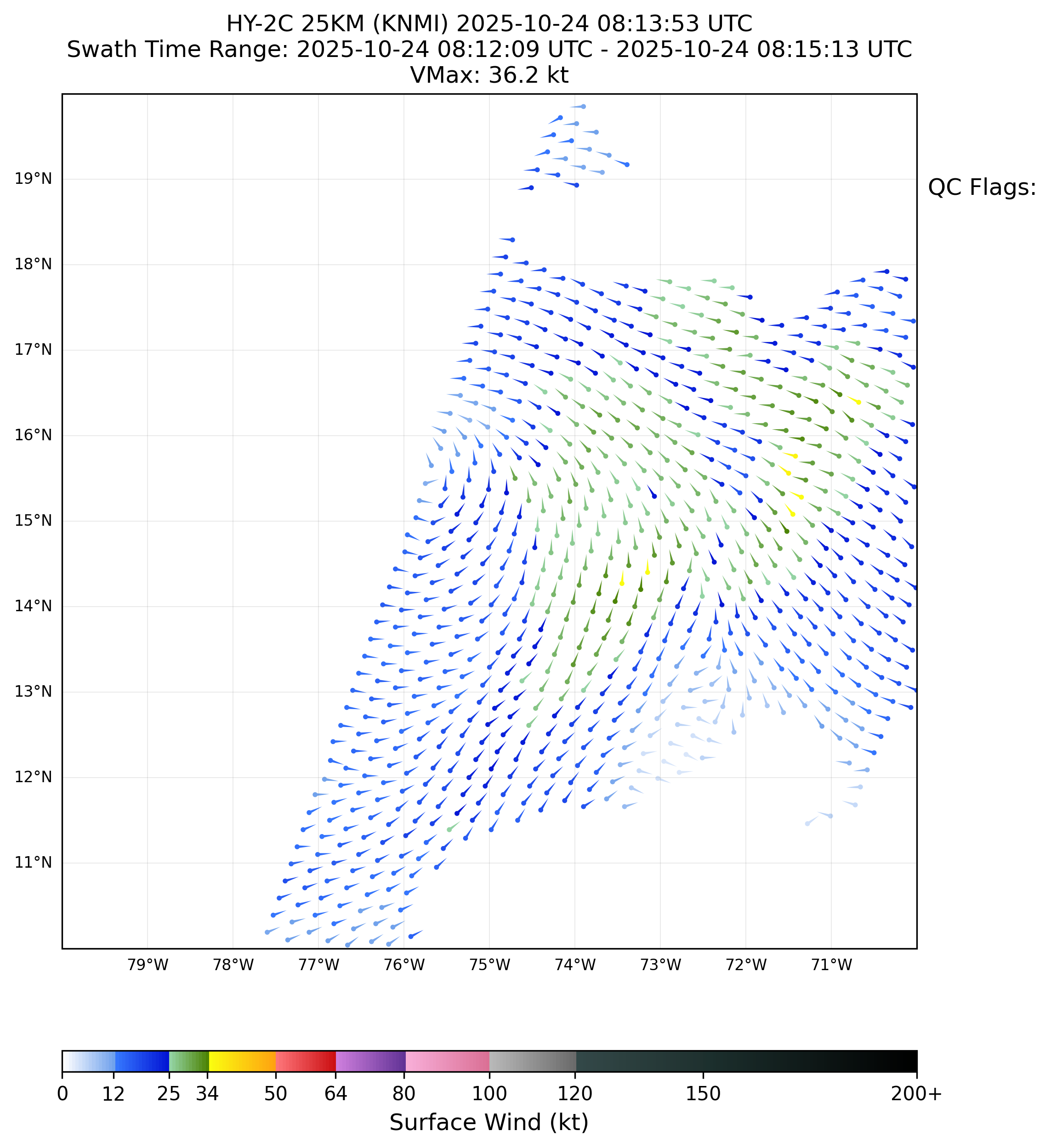
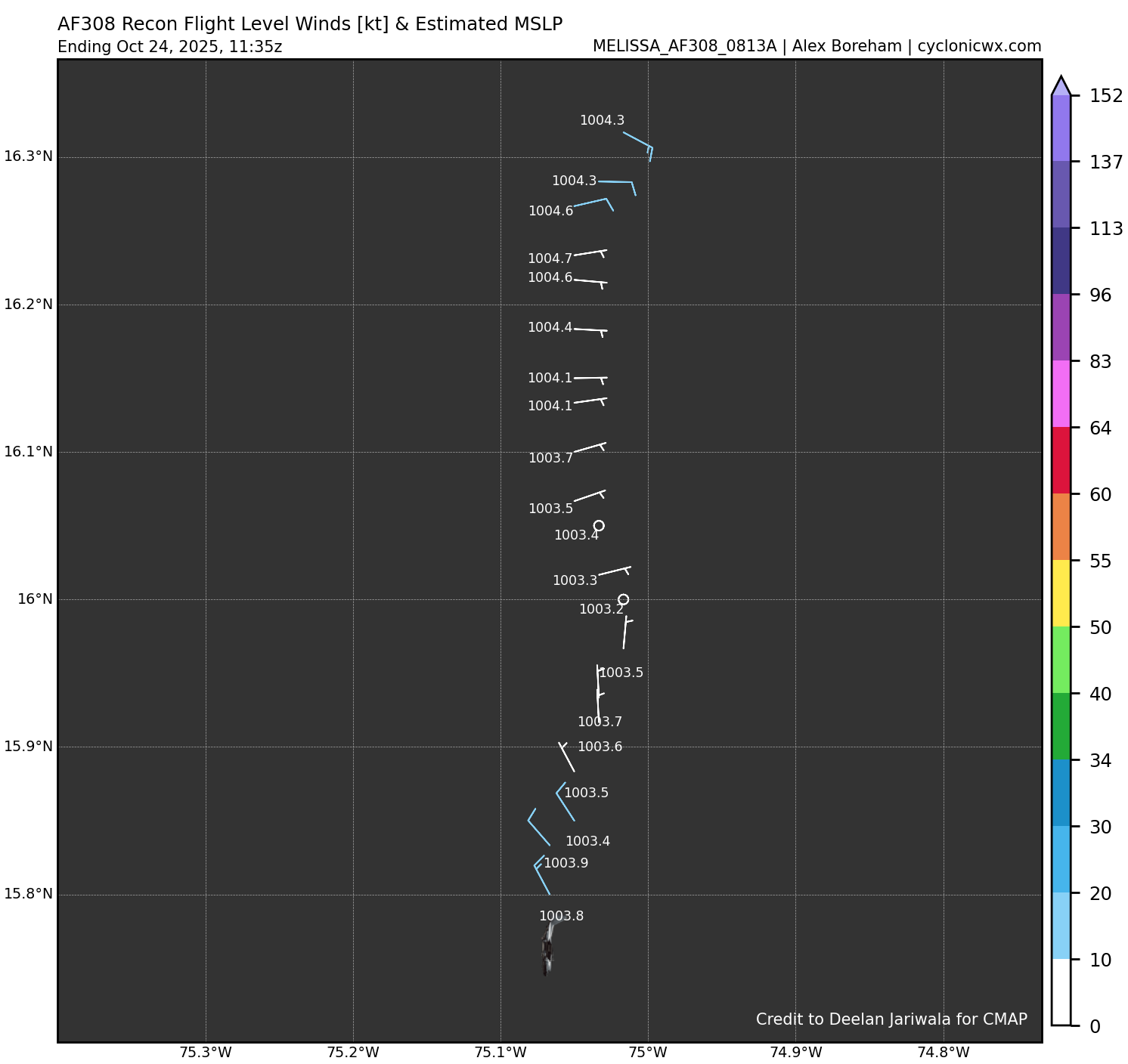
Latest low level recon (near the 850 mb level) from 11:35Z appears to show the low level center (somewhere in the neighborhood of 16.1N, 75.1W), and a bit east of the last (06Z) storm center position (this eastward shift was expected from the model tracks for today; this is NE of my surface center fix from scatteromter pass ~3-4 hours ago)...
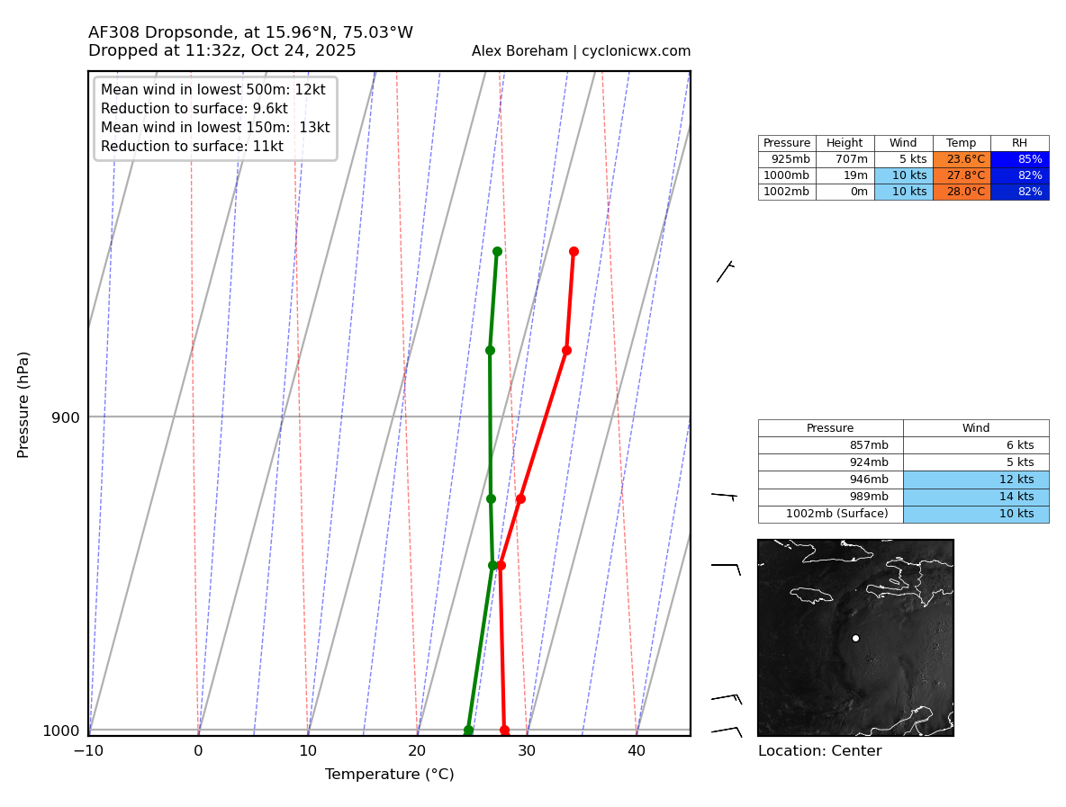
Together with the last center-dropsonde (16W, 75N), this seems to imply the surface center is more likely still to the west of 75W (if not shifted a bit south) but its difficult to tell.
If the surface circulation does shift more east or southeast (or at least stretches west to east) we should expect the next scatterometer passes to cover more of the eastern part of the circulation.
GFS/06Z still has the center far east of where I think it currently is... but the HY-2B (overpass in about half an hour) swath implies we will miss the center if it stays where it is roughly (might become available in a couple hours if its not late) -- might possibly indicate whether the eastern part of the circulation is becoming more disorganized/elongated ...
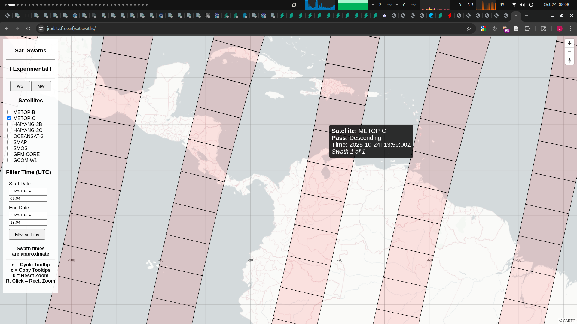
The Metop-C pass will almost certainly miss the center (unless it very unlikely reforms east of 73W in the next 2 hours (~14Z over pass); thus the HY-2B scatterometer pass in the next 30 mins is the last one we will get that has a slim chance of catching something happening before market close).
GEFS/06Z still has a lot of spread but the mean is towards central Jamaica, but GFS still tracking northwards in between Haiti and Jamaica.
~
For future reference, I still don't have much faith in the regional models as far as steering (and thus track/intensity when it is still unaligned) so I continue to rely on the old 00Z EPS/Google guidance until Google 06Z comes out...
Google 06Z mean track has shifted east and the mean intensity seems a tiny bit higher than 00Z, staying above 130kt for 19 hours... based on this alone I'm updating a bit higher for cat.5 again:
2510270800 ( +16.19, -77.20) 130.4
2510270900 ( +16.20, -77.25) 130.8
2510271000 ( +16.20, -77.30) 131.3
2510271100 ( +16.21, -77.35) 131.7
2510271200 ( +16.21, -77.40) 132.2
2510271300 ( +16.23, -77.44) 132.4
2510271400 ( +16.24, -77.48) 132.7
2510271500 ( +16.26, -77.52) 133.0
2510271600 ( +16.28, -77.57) 133.2
2510271700 ( +16.30, -77.61) 133.5
2510271800 ( +16.31, -77.65) 133.8
2510271900 ( +16.34, -77.68) 133.5
2510272000 ( +16.38, -77.71) 133.2
2510272100 ( +16.41, -77.74) 132.9
2510272200 ( +16.44, -77.77) 132.7
2510272300 ( +16.47, -77.80) 132.4
2510280000 ( +16.50, -77.82) 132.1
2510280100 ( +16.56, -77.83) 131.3
2510280200 ( +16.62, -77.83) 130.5
Google 06Z Vmax and pressure:
@parhizj The track forecast has shifted towards the track that would favor the highest intensity solutions, but looking at the environment, it doesn't actually seem ideal - the storm is under moderate shear for basically the entire time it's intensifying, and the western tracks being favored bring it into the vicinity of dry air:

But most models are unanimously showing C4 / C5 intensity anyway, I think simply because of the ridiculous sea surface temps common in the Caribbean at this time of year. The storm's movement is slow enough to trigger some upwelling, but the very high OHC in the region is enough to make this a non-factor:
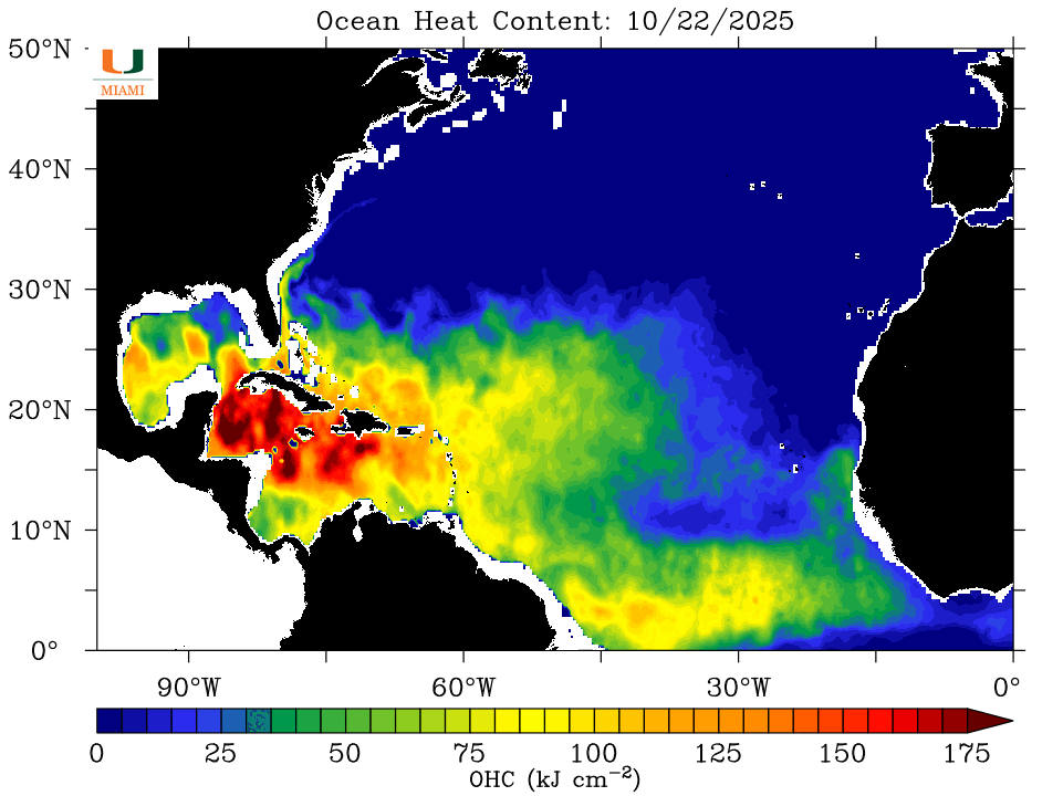
I think this environment is not supportive of the very high end pinhole eye solutions that the HAFS models have been intermittently showing over the last couple days - the storm last year that is the closest analog to this one is probably Beryl, not Milton. My median is still something like a 930 mb high-end Category 4, which is a little stronger than what the NHC is officially forecasting.
Also, shoutouts to the 6z operational GFS for finally giving up on its outlier Haiti landfall solution, after insisting on it for days...it's still a far eastern outlier, but it's at least moving closer to reality...
@SaviorofPlant I basically agree with what you said being it less than ideal in terms of shear (especially in the short term until it becomes a hurricane), but I doubt dry air will be a limiting factor once it becomes a major hurricane as I am expecting the storm will become likely very large (so I am expecting it should condition its own local environment enough to near ideal).
@SaviorofPlant Market is closed. Final thoughts?
~
I didn't get a chance earlier to look at model data again but glancing at ECM/06Z confirms your hypothesis that a far westerly track is bad for the ideal scenario as it has reduced the peak intensity by quite a bit.
Comparing ECM/06Z and Google/06Z in ~3 days it seems ECM (which is a bit weaker now as far as peak intensity) believes it will move further SW then the google mean before taking its turn NE (~27/18Z -- this is roughly the timing Google gives the middle of its peak intensity period) -- these far SW members of Google (about 10) all reach cat. 5 (while ECM only shows less deepening, from 945-950 (which would be a cat3-4 normally) near the turn NE to as deep as 938 mb as it approaches Jamaica (what would be normally a solid cat 4, but ECM doesn't place it that high either due to biases or actual structural weakness from dry-air and land interactions). Both Google mean (43/50 members) and ECM/06Z then end up landfalling hitting the middle of Jamaica's southern coast, but the 8/50 google members that landfall as a cat 5 favor the west side (Edit2: a turn NE without it going too far west seems to favor less strengthening -- not sure why there is still a large spread other than the models still don't have a clear lead at this point when its disorganized).
However given the more recent movement SE I think this bodes ominously for a slightly more eastern track like Google 06Z which strikes the middle of southern Jamaican coast as it should encounter slightly less dry air? However if it ends up turning very early NE as some members do, then the chances are less likely for a cat 5.
I thought cat. 3 is under-valued based on EPS/00Z last night and ECM/06Z, so I bet that up a bit before close.
So for the market close I've leaned more towards the Google track, in terms of how far west it will end up tracking as it has been trending in a more eastern direction in the last few runs in terms of Jamaican landfall, and thus I've kept my bet as it was earlier without betting up cat.5 more considering ECM/06Z has some weight to the environment being less ideal in the more SW track + dry air intrusion scenarios.
@parhizj Eye-like feature has started to open up in the last 15 minutes or so of satellite imagery, indicating early RI, so I think that means Melissa will be slightly to the north of the track forecast?
@parhizj I don't disagree with basically anything you've said here, I also bet up Cat 3 earlier this morning as the market had it at a ridiculously low 3%. As @Calibrate has noticed it looks like the heavy shear has finally abated, and the storm is likely to intensify from this point onwards. I think based on Melissa's current location, the tracks that miss Jamaica to the west seem to be increasingly unlikely, and if the market was still open I probably wouldn't adjust my positions much (might buy a little more Cat 4 and sell a little Cat 5). The models will probably start converging on a track in the next day or so now that the uncertainty regarding center locations has finally cleared up.
@Calibrate The NHC did issue an update mentioning strengthening based on hurricane hunter recon (putting it at ~50 kt) and it does look like it is quickly organizing.
As for track I don't know -- I did expect it to organize later today but this seems a bit early.
Not sure what you are talking about eye-like feature... are you only looking at vis.? Also what site are you using to view imagery (give timetamps and channel) or annotate the image ?
Either way I'm going to move to posting to the other minimum pressure market:
@parhizj The feature I was looking at quickly disappeared, so I assume it was just a chance alignment of clouds. It did look like a tiny pinhole eye for a little bit, though.
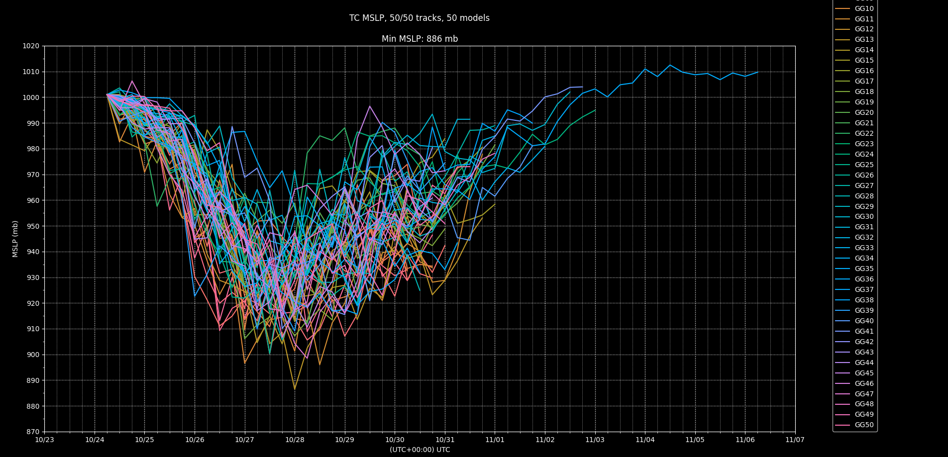
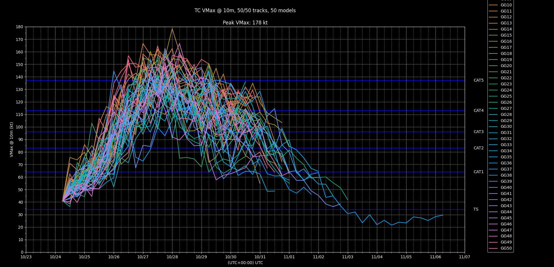
EPS has over the last few runs kept a decent portion of its ensemble below hurricane strength (12Z with about 30%). Google/18Z has 78% of its members with a point reaching cat. 5 intensity, and 22% reaching cat. 4 (i.e. 0/50 members not reaching cat 4 or higher). Given the below and that the mean tracks for both ensembles more or less agree on the steering scenario (despite a large amount of uncertainty in the track spread for both), for this market after the analysis below, I weight roughly between EPS/12Z and Google/12Z for any members with a point exceeding the vmax -- yielding probabilities for cat 5 to ts of 43%, 22%, 11%, 4%, 4%, 16%, and then discounted placing yet even more bets for the TS scenario (it remaining a strong TS) given I am already over weight on 50-64kt. Melissa still has yet to reach 50 kt, and this seems a sure thing that it will but I hedged finally anyway a bit given it hasn't happened yet (there isn't really model support for this though).
~
Regarding the GFS model runs today, from examining the 10m surface winds as far as I can tell it seems that it was expecting a cell to the east (near 73 W or so) to cause the surface wind circulation to reform around it, however despite briefly seeing a chance for this earlier on it never materialized despite it keeping on predicting it persistently (the 21Z NHC discussion mentions this possibility in the regional models over night).
While the center was at the far west end of the storm I did note some brief small cell of deep convection (before the LLCC became exposed) directly east but this wasn't sustained. Regardless, its hard to tell how acccurate the GFS model's steering will be in this scenario where it reforms eastwards and heads north and strengthens; there are enough samples of this in EPS/12Z though and I recall generally 10% of these tracks remain a TS in various scenarios).
~
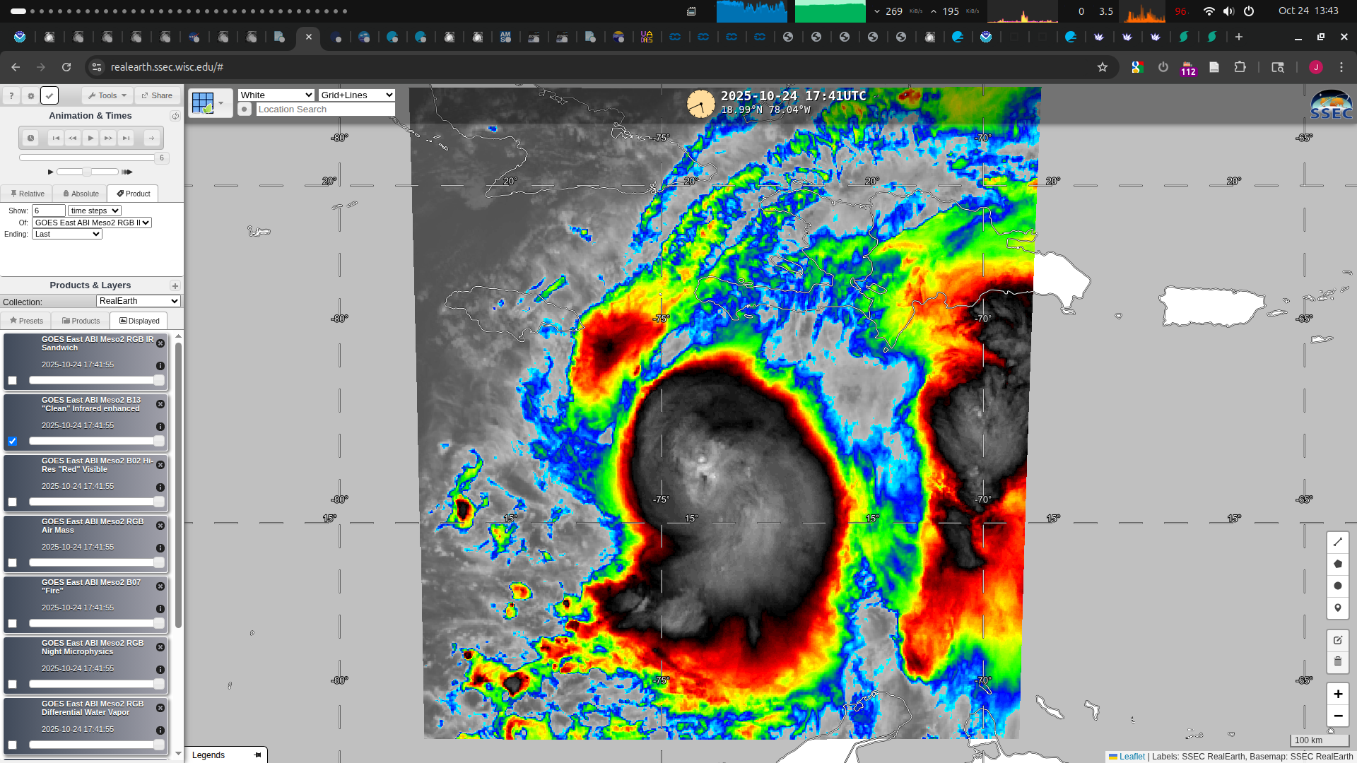
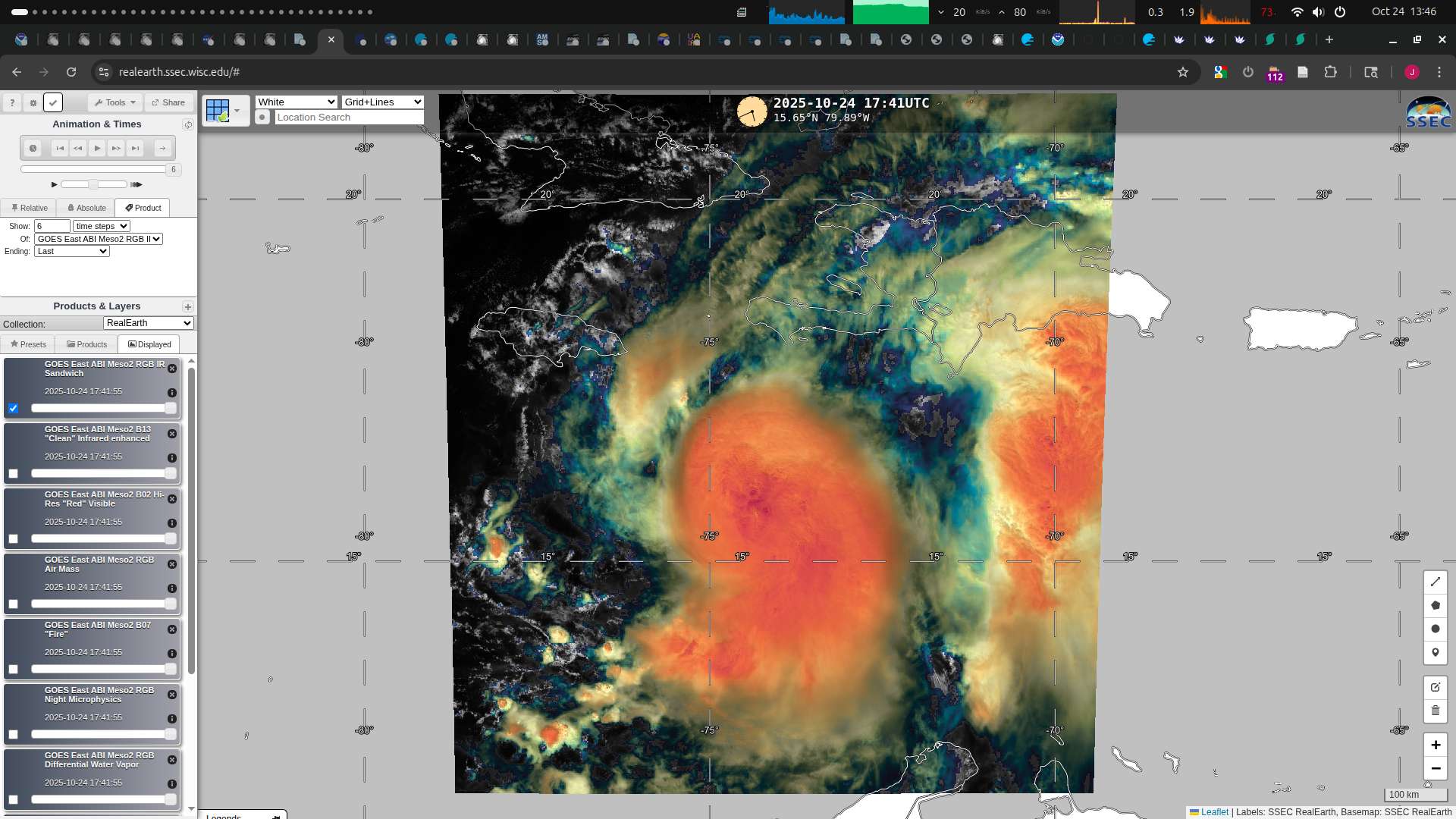
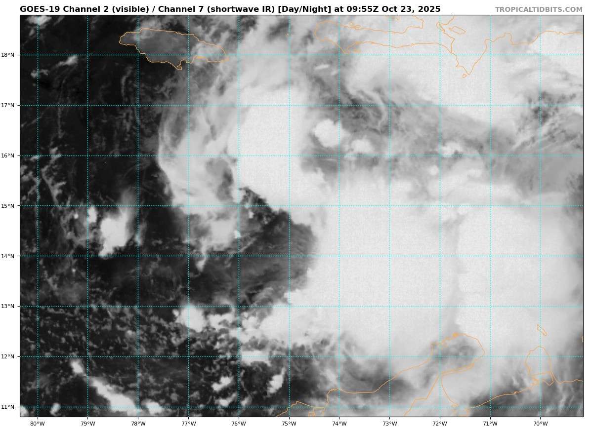
The surface circulation became exposed a few hours before sunset, and was visible in GOES-East imagery; I estimated the LLCC roughly near 16.08 N, 76.11 W at 19Z from examining 1 min meso vis. imagery from when it was exposed.
~
I did do some sensitivity analysis for the EPS/12Z and Google/12Z tracks, subsetting around this fix with smaller and smaller boxes at the interpolated 19Z point):
Generally subsetting for Google/12Z caused the track to shift generally more NE, with the mean of the subsets shifting the Jamaica landfall slighty SE from near the western tip more eastwards (10-30 NM) (did not see much effect on landfall timing), the couple outliers far east and west don't seem to effect the subsetting track or timing as they seem to balance.
As for EPS there is much more spread, and subsetting seemed generally inconclusive (it started shifting the track SW of the mean for larger subsets, but then for small samples it shifted the track NE of the mean)
~
So what to look out for is any indication of a large shift of the surface circulation east (which is still a possibility (there is at least 1 Google outlier that shifts it east ward even if it ends up still very strong due to meandering).
~
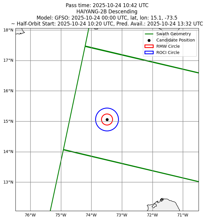
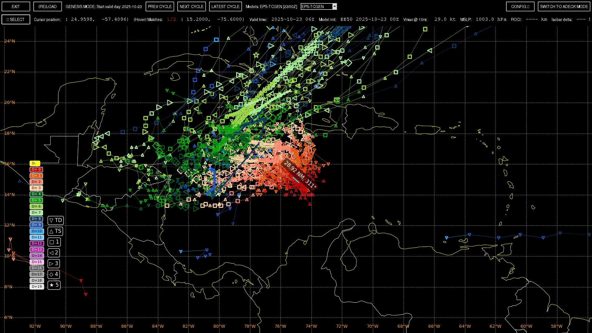
Given that the surface center should be roughly around 15N, 75 W, until the market closes looks like we are destined for partial scatterometer passes ..
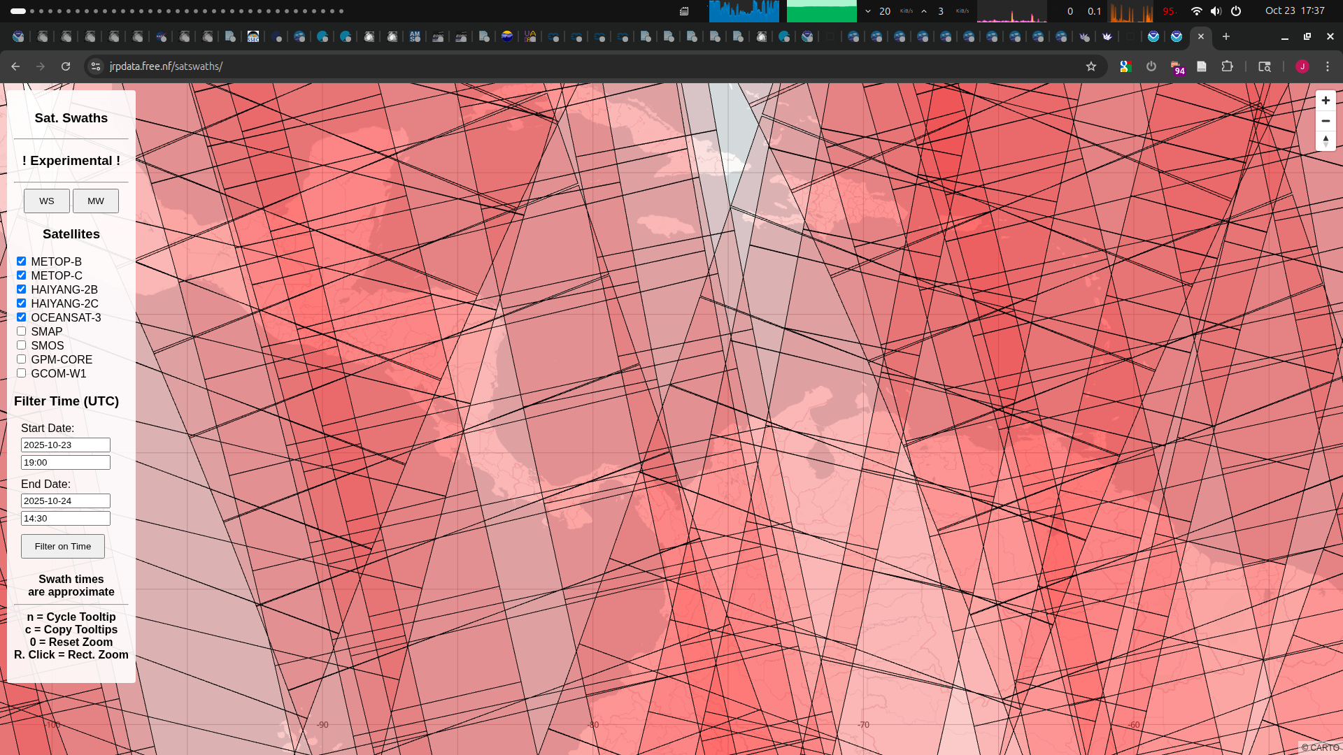
For microwave imagery, GCOM-W1 and GPM-CORE will likely miss for the time frame also...
~
Scatterometer overpass predictions for 23/19:00Z to 24/14:30Z:
--
Nadir West of 15N, 75W:
Satellite: HAIYANG-2B
Pass: Ascending
Time: 2025-10-23T23:32:00Z
Swath 1 of 3
* Satellite: METOP-B
Pass: Ascending
Time: 2025-10-24T02:22:00Z
Swath 2 of 3
Satellite: OCEANSAT-3
Pass: Ascending
Time: 2025-10-24T05:31:00Z
Swath 3 of 3
--
Nadir East of 15N, 75W
* Satellite: HAIYANG-2C
Pass: Ascending
Time: 2025-10-24T08:14:00Z
Swath 1 of 3
Satellite: HAIYANG-2B
Pass: Descending
Time: 2025-10-24T10:43:00Z
Swath 2 of 3
Satellite: METOP-C
Pass: Descending
Time: 2025-10-24T14:00:00Z
Swath 3 of 3
~
No idea how good the coverage will be as the center will be uncertain ...
@SaviorofPlant see discussion 5 below again.. they use 3 conjugates of “challenge” in the same advisory.
@parhizj Recent IR satellite imagery seems to suggest the center is reforming significantly to the NNW -- any insights? I thought maybe this could result in a weaker storm, so I've moved some of my positions around accordingly.
@Calibrate ? I haven’t looked at it for hours, and just glanced at it I don’t see what you are talking about it reforming NNW (unless you mean less recently like i mention in the above post?). I do see the dry air that was forecast has clearly arrived now and appears to already have taken a chunk out of the convection.
As far as intensity, the models aren’t in agreement, so you can only try to guess.. the 03Z discussion lays out the scenarios for track, and the models aren’t in agreement about it, and the track will determine the intensity.
The environment will heavily favor RI, the longer it sticks around in the Caribbean the better its chances of organizing and becoming a very powerful hurricane
@parhizj I was thinking that the short-term intensity and center position would determine the track and maybe the long-term intensity? Not sure.
It did look over the past few hours that the center shifted from the more southern clump of convection to the more northern clump of convection near Jamaica, but it's difficult to tell now that the convection is being eroded by the dry air you mentioned.
Seems a bit more chaotic based on what I analyzed but it's hard to tell. Ultimately I do have a bit more confidence in EPS/00Z today, but I'm ambivalent between EPS and Google as their steering ensemble are roughly in agreement and EPS has less outliers now.
~
ECM/00Z and the regional models appear to show the center elongating and forming a bit eastwards sometime today but they disagree about the eventual track once again -- the regional models take a more northerly approach and approach Jamaica from the East while EPS/Google 00Z (including ECM) generally follow the same steering pattern as previously -- after some meandering today, eventually heading west and approaching Jamaica from the S or SW (the mean landfalling near the western tip). There is one google member outlier I recall though that follows GFS on the northerly track toward Haiti; otherwise Google probabilities are mostly unchanged with the notable exception that the mean intensity of its members has increased a bit such that the peak reaches above 130 kt now for several hours:
2510280200 ( +16.22, -78.49) 130.0
2510280300 ( +16.27, -78.50) 130.6
2510280400 ( +16.32, -78.52) 131.1
2510280500 ( +16.37, -78.53) 131.7
2510280600 ( +16.42, -78.54) 132.3
2510280700 ( +16.51, -78.54) 132.3
2510280800 ( +16.59, -78.54) 132.2
2510280900 ( +16.67, -78.53) 132.2
2510281000 ( +16.75, -78.53) 132.2
2510281100 ( +16.83, -78.53) 132.2
2510281200 ( +16.91, -78.53) 132.2
2510281300 ( +17.01, -78.51) 131.5
2510281400 ( +17.11, -78.50) 130.9
2510281500 ( +17.21, -78.49) 130.2
~
Based on the scatterometer data the very large eastward shift in track (predicted by GFS) didn't occur, and the EPS/00Z models notably have cut back on the northerly scenarios by and large, and as such the probabilities for it not becoming a hurricane have decreased (to about 10% of members). Looking at the models it does some meandering to the east will happen if the center gets stretched as it tries to get aligned over the next 24 hours (helped by the dry air interrupting the western part of the convection now where the surface center was). From the WV this seems like its going to happen sooner rather than later...
One day left of trading.
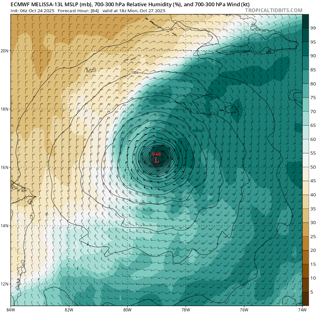
Still a ton of track uncertainty, which seems like it will affect intensity quite a bit. The Haiti solution the GFS has been insisting on for days seems unlikely at this point (though hard to rule out), but I've seen model outputs missing Jamaica in both directions, as well as ones going quite far south. Looking briefly at GDM ensembles, I think the tracks going more south initially, then west of Jamaica are the ones with the highest intensity. My median here is probably on the border between Cat 4 and Cat 5 but there's a surprising number of ensemble members that don't reach Cat 3.
The storm still has an extremely sheared appearance on satellite, and another center relocation seems possible, which is probably a big factor in the track uncertainty.
Once this closes, I might make a lower liquidity live-trading minimum pressure market like I did for Milton last year.
Based on the below I still find the broader EPS intensity distribution more compelling than Google, and continue to bet more agnostically, but only very conservatively as I don't have much confidence at all in the models at the moment.
~
The straightforward northerly tracks for GFS and a few GEFS members reaching Haiti do increasingly look like an outlier given the steering scenario hasn't changed much per NHC, but I expect we likely won't know for another day unless the storm manages to organise more than expected today. I am slightly concerned the tilt has caused the model initializations to be a bit further SE than the models would expect for their surface center...
Last night I noted far W and NW of the surface center some decent scattered convection started at sunset, and it continued last night; this seems to have moistened the environment where previously it was a bit dry from the shear, and now we are finally seeing some more convection the last few hours NW of the surface center. I do recall that in one of the HAFS runs yesterday it very briefly tried to get organized (forming a small eye like feature) before getting cutoff again from the shear. If the surface winds can be sustained in the NW (as shown in the scatterometer pass) this bodes better for faster organization scenarios.
~
Notably in Google/00Z most of the extreme western tracking outliers have disappeared (something common lately in the google runs is despite the normal fixed initialization from all its members as usual, the subsequent T+6h points in the runs have had a larger than usual spread -- this effectively seems to make it similar to the other dynamic models that randomize the initialization positions)
For the roughly ~25% of members of EPS/00Z that don't reach hurricane status, their subsetted mean track begins to diverge from the mean track after around 18Z tonight, steering further north than the mean track before following the same general pattern -- they end up tracking more closely along the coast of Jamaica (would expect more shear further north, shallower waters and more land interaction in the short term to cause it to have a weaker peak vmax)
(thicker lines are the subsetted mean track (north) and mean track):
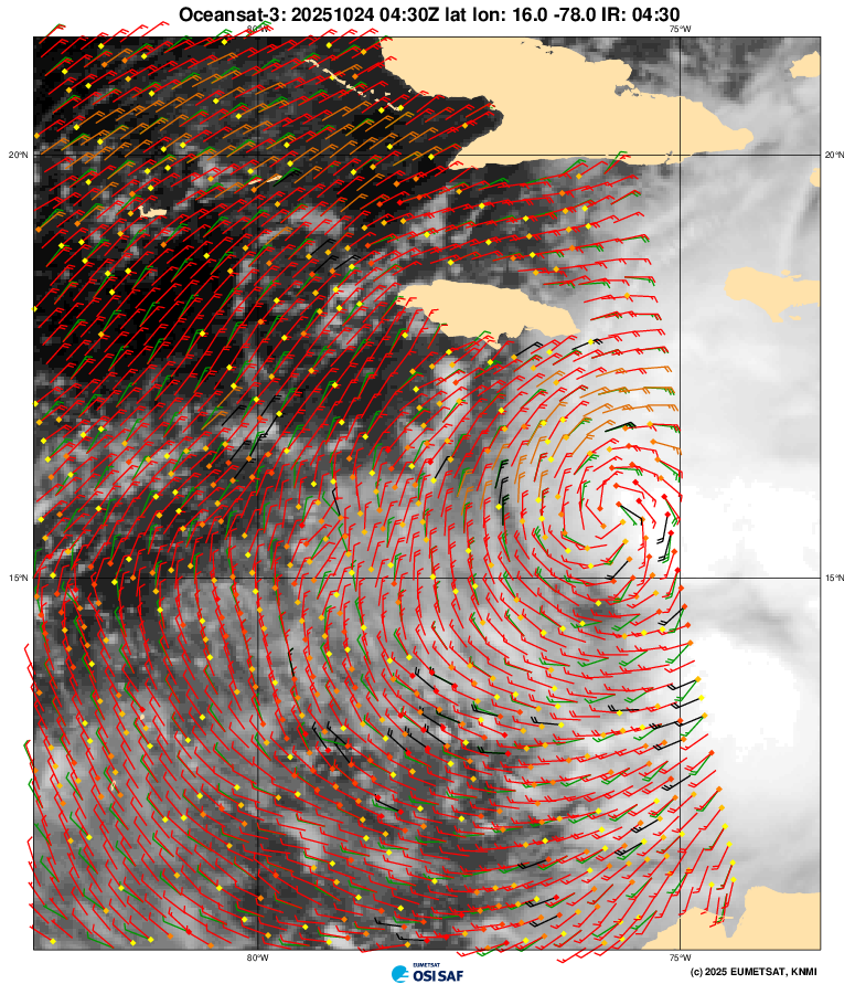
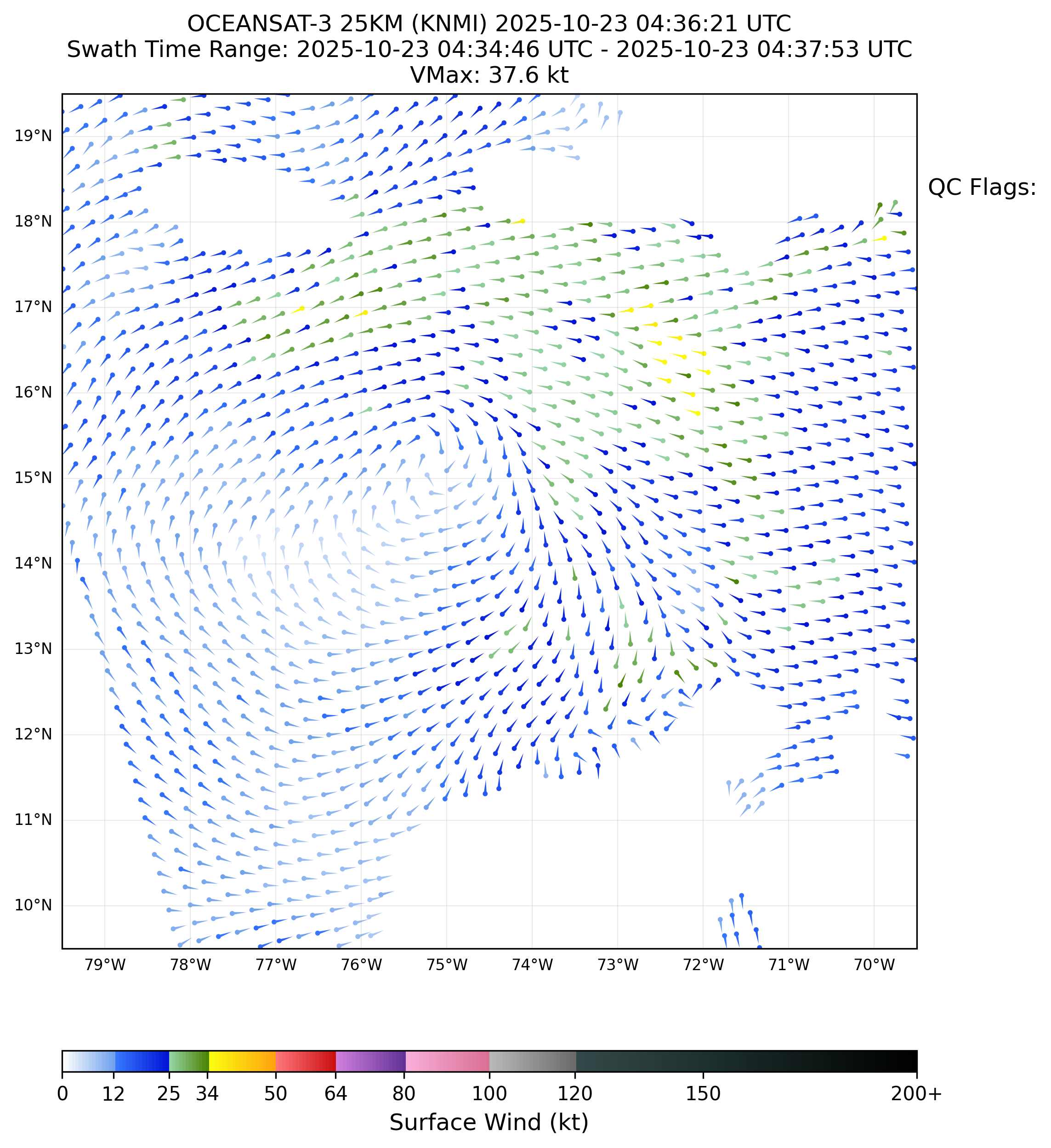
Based on the oceansat-3 pass I fix the surface center (15.19 N, 75.13 W) NW of the (linearly interpolated) mean track for EPS and Google (EPS is ~30 NM SE, and google ~50 NM SE of the scatterometer pass). (Given the NHC is feeding the center fixes for the storm center rather than surface center, and the storm is tilted quite a bit, this is understandable).
As mentioned in the 09Z NHC discussion the intensity (rated 45 kt) could be a tiny bit overestimated as even with the rain-flagged cells peak vmax is 38 kt (40 kt looks a bit more realistic from this alone)
If the center doesn't reform, the mean tracks from the dynamic models might be a tiny bit too far SE, so possibly the northern scenario might become more likely tomorrow (if the axis tilt is influenced by the above).
If the dynamic models are being initialized slightly further SE than they "should" be from the axis tilt, I would expect the nothern track scenarios to be more likely than the models suggest -- expecting to start to eliminate (or confirm) some of those weaker more northern tracks from the EPS 00Z runs tomorrow, given the slight divergence in track happens later today.
pretty drastic uptick in guidance tonight, all hurricane models now showing a major and all except HWRF depict a category 5 by the 26th; the 0z operational euro has that as well. i have aggressively bought shares predicting an 80% chance of a major and 33% chance of cat 5. this reminds me of milton last year where i was initially thinking TS or cat 1 and suddenly the HAFS was spitting out <900 mb runs. not that i think that's super likely to actually pan out, but i would be pretty surprised if we're getting this type of output for a storm that ends up being like 85 kt max
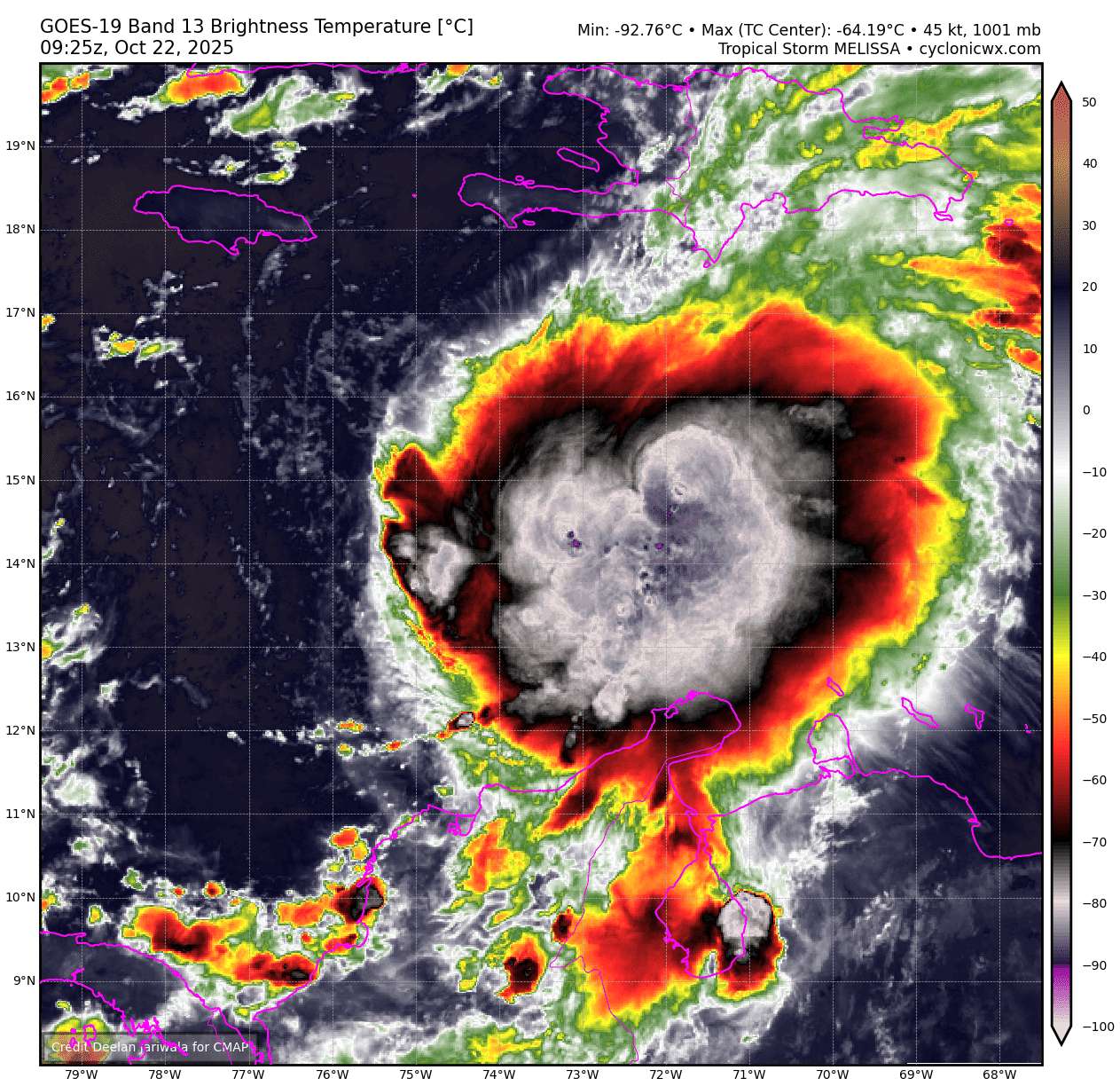
@SaviorofPlant I think based on what I saw last night and the amount of deep convection we are getting now (7 hours straight of -90C tops so far) this system appears to me more aligned than the models yesterday but GEFS/00Z has less members of that quick solution heading north now, and a more ambiguous spread with slower development; latest EPS control member does show a more aligned model now but I won't have much confidence in the 00Z-06Z ensembles; not sure if we should believe even the RI predictions either (NHC not forecasting RI) given this intense convection over the last 7 hours.
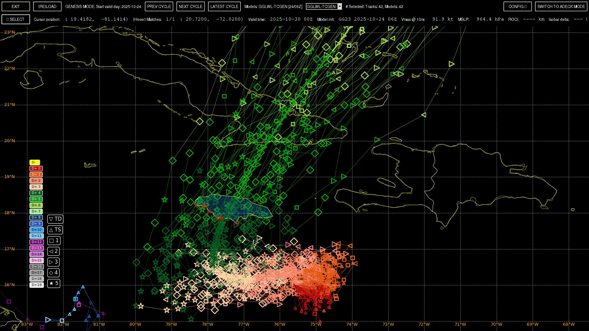
Google/00Z shows more spread without any clear signal as to track, but does seem to split into roughly three solutions, the majority of which approach Jamaica, another following a (more easterly) track towards Hispaniola, and a smaller set heading further W or SW of Jamaica before turning N/NE.
Got to wait to we see if the center has shifted east again with this new bout of convection (as the NHC did last night); not sure how stable the center is at the moment, and until we get a stable center I don't have a good idea of what scenarios are plausible, as such I've more or less hedged with a more agnostic attitude; lumping the more westerly Google 00Z scenarios together (which is about 58% of members) considers a cat 5 most likely, and the other eastern scenario (42%) (which considers a cat 1 most likely)).
with the exception of ECM 06Z, GFS/06Z and the other regional models continue to show the surface center jumping around a little bit for the next couple days … given the synoptic situation seems especially important I don’t place much emphasis on the nested models further out in time.
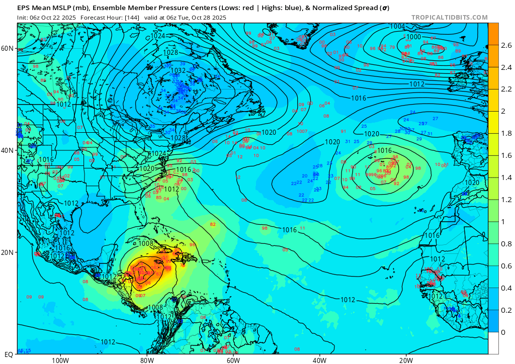
EPS 06Z has most of the members taking a westerly track..
The ECM 06Z model shows a drier environment (wind shear) while the GFS is more wet over the next couple days. GFS 06Z also shows the ROCI shrinking in the next few hours, so we will see by the 18Z run whether this verifies..
the NHC discussion from the 15Z advisory …
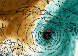
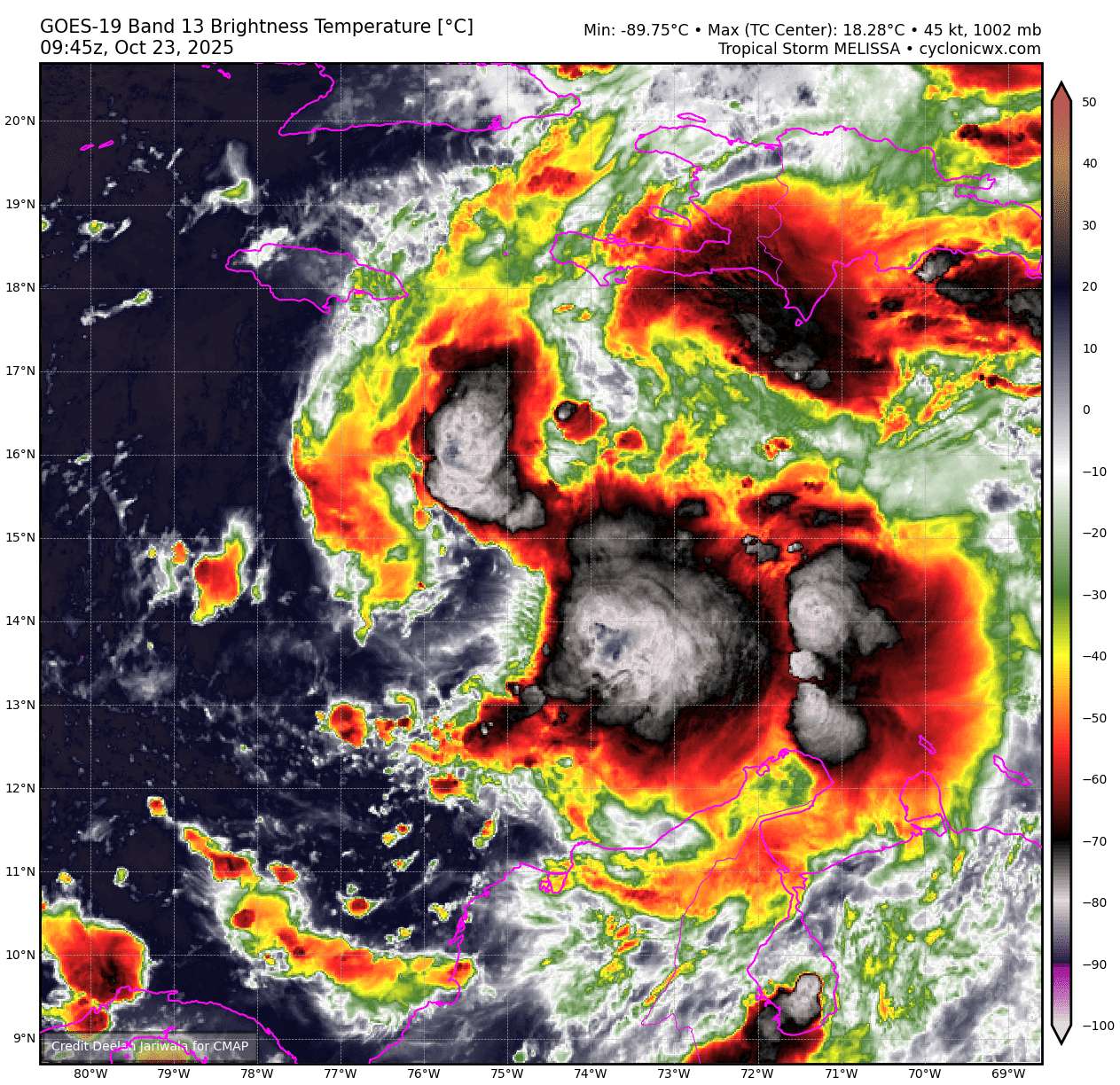
Tropical Storm Melissa Discussion Number   5
NWS National Hurricane Center Miami FL       AL132025
1100 AM EDT Wed Oct 22 2025

While Melissa continues to produce bursting convection on satellite
imagery, with very cold cloud tops down to -95C, there is little
evidence these convective bands are wrapping around the center.
West-northwesterly shear of 20 to 25 kt is currently preventing the
low-level and mid-level circulation centers from aligning. This
downshear tilt with height has also been observed by the latest Air
Force Reconnaissance mission, which reported significant winds at
the surface in their most recent 850 mb center drop. The initial
intensity for this advisory is held at 45 kt, taking a blend of
recon observations which had a peak wind of 52 kt at 850 mb, and
satellite intensity estimates from TAFB, ADT, and D-MINT. The wind
field of Melissa also remains very asymmetric, as evidence of a
recent 1040z RCM-1 Synthetic Aperture Radar pass showing the bulk of
tropical-storm-force winds east of the center.

The tropical storm has slowed down to a crawl this morning, with the
estimated motion at 300/2 kt. The track forecast remains challenging
today, and strongly related to the storm's structure in the
short-term. For the next 12-24 hours, Melissa is forecast to move
very slowly to the northwest as it attempts to move into a weakness
produced by an broad upper-level trough centered over the Bahamas.
Whether or not it turns more rightward into this weakness is related
to the vertical depth the various model guidance is depicting. The
06z GFS run, which is the model that has been on the right side of
the guidance envelope for days, shows a more vertically coherent
system over the next 24-48 hours, and causes Melissa to abruptly
turn northeastward over the next 48 hours. While this appears to be
an outlier solution, the Google DeepMind ensemble mean (GDMI) also
shows this northeastward motion, and a significant fraction of its
ensemble members show the Melissa making landfall on the Island of
Hispaniola. However, the remainder of the track guidance, including
the ECMWF and its ensemble mean, suggest that Melissa will remain
misaligned and move more slowly north-northwest over the next couple
of days. The NHC track solution slightly favors the latter
scenarios, lying just east of the ECMWF mean, out of respect of the
reliable GDMI aid. After about 60 h, mid-level ridging begins to
build back in to the north, and most of the guidance responds by
showing a sharp turn westward, albeit still at a snail's pace. The
overall track guidance, GFS and GDMI excluded, has shifted left this
cycle beyond 72 h, and the NHC track was shifted in that direction,
but not as far south and west as the HAFS-A/B regional models. It
goes without saying, this is a very challenging track forecast.

The intensity forecast has its own share of challenges. At least in
the short-term, vertical wind shear is expected to persist between
20 to 30 kt, and will likely prevent Melissa from becoming fully
aligned and taking advantage over the very warm 30-31C sea surface
temperatures. After about 48 hours, the GFS and ECMWF-based SHIPS
guidance shows the shear decreasing gradually, but the timing on
when the system becomes more vertically coherent varies among both
the global and hurricane-regional model guidance. Most of the
guidance shows significant or even rapid intensification in days
3-5, and the NHC intensity forecast was raised once again during
this time frame, but not as high as the HCCA or hurricane-regional
models due to continuity constraints to the previous forecast. The
day 5 forecast now shows Melissa becoming a major hurricane, and
further upward adjustments may be necessary in subsequent cycles.
The intensity forecast is also more uncertain than usual, in large
part related to the track uncertainty.

Key Messages:

1. Melissa is expected to produce heavy rainfall across portions of
the Dominican Republic, Haiti, and Jamaica through this weekend,
bringing a risk of significant flash flooding and landslides.

2. Hurricane conditions are possible in the southwestern peninsula
of Haiti where a Hurricane Watch is in effect.  A Tropical Storm
Watch is in effect for Jamaica.  Preparations to protect life and
property should be completed by Thursday.

3. There is significant uncertainty in the track and intensity
forecast of Melissa.  Interests elsewhere in Hispaniola and Cuba
should continue to monitor the latest forecasts.


FORECAST POSITIONS AND MAX WINDS

INIT  22/1500Z 14.4N  73.6W   45 KT  50 MPH
 12H  23/0000Z 14.8N  73.9W   45 KT  50 MPH
 24H  23/1200Z 15.2N  74.3W   50 KT  60 MPH
 36H  24/0000Z 15.6N  74.4W   55 KT  65 MPH
 48H  24/1200Z 16.0N  74.4W   55 KT  65 MPH
 60H  25/0000Z 16.3N  74.6W   60 KT  70 MPH
 72H  25/1200Z 16.5N  74.9W   70 KT  80 MPH
 96H  26/1200Z 16.6N  75.8W   90 KT 105 MPH
120H  27/1200Z 16.4N  77.4W  105 KT 120 MPH

$$
Forecaster Papin@parhizj Was about to quote that advisory text lol. At this point this is more of a track forecasting market than an intensity one.
Still some chance the GFS solution is right, and this market should probably be showing more of a bimodal distribution than it currently is. But worth noting that the environment seems to be very favorable if it takes the central (Jamaica) track: https://x.com/AndyHazelton/status/1980986083694277108

@SaviorofPlant in terms of SST and OHC the Caribbean has been waiting all year for this system and normally predicting based on the environment is a good way to go, but how do you predict on the environment here even short term if it appears the environment has so much fuel it’s potentially too unstable (more like the WPAC)? I don’t know if these convective bursts to the east of the given center, that have provided -90C tops for going on 14 hours now, are going to end up stabilizing it early or not. This is the most 48 hour track disagreement I can recall this year so far for the Atlantic.
aside from ongoing recon, we should get a solid HY2C pass later tonight to see if it has contracted or reformed elsewhere, and another microwave pass (GCOM-W1 18:30Z) for sure also for structure.
I looked at some of the regional models analysis earlier (HAFSB, etc) -- it looks like some mid-upper level dry air intrusion has also prevented it from organizing.
NHC in the 21Z advisory now predicts RI later on, still favoring the (meandering but mainly) westerly track scenario with it remaining weak and disorganized for the next few days, before later becoming a cat-3 and possibly stronger further on, albeit all with low confidence.
EPS/12Z actually has a majority of its members not becoming a major hurricane (56%). Based on this I'm hedging now half way between EPS/12Z and Google/12Z, remaining fairly agnostic about what will happen in the next couple days; I've also increased the hedge on it not even becoming a hurricane, given ~20% of EPS members not becoming a hurricane.