Background
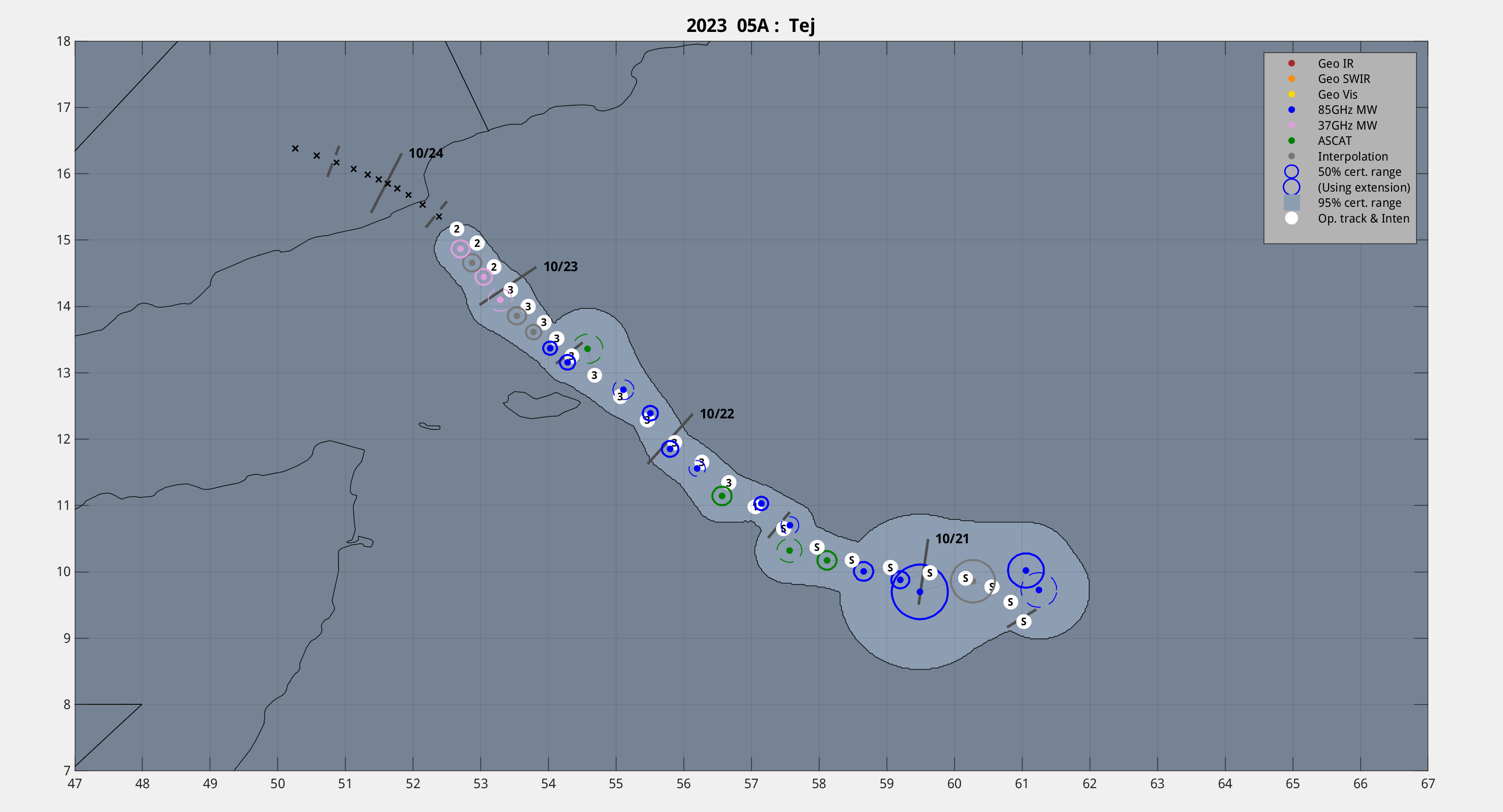
Extremely Severe Cyclonic Storm Tej is a tropical cyclone currently in the North Indian ocean, recently intensifying into an Extremely Severe Cyclonic Storm. It is currently at a strength equivalent of a Category 3 hurricane.
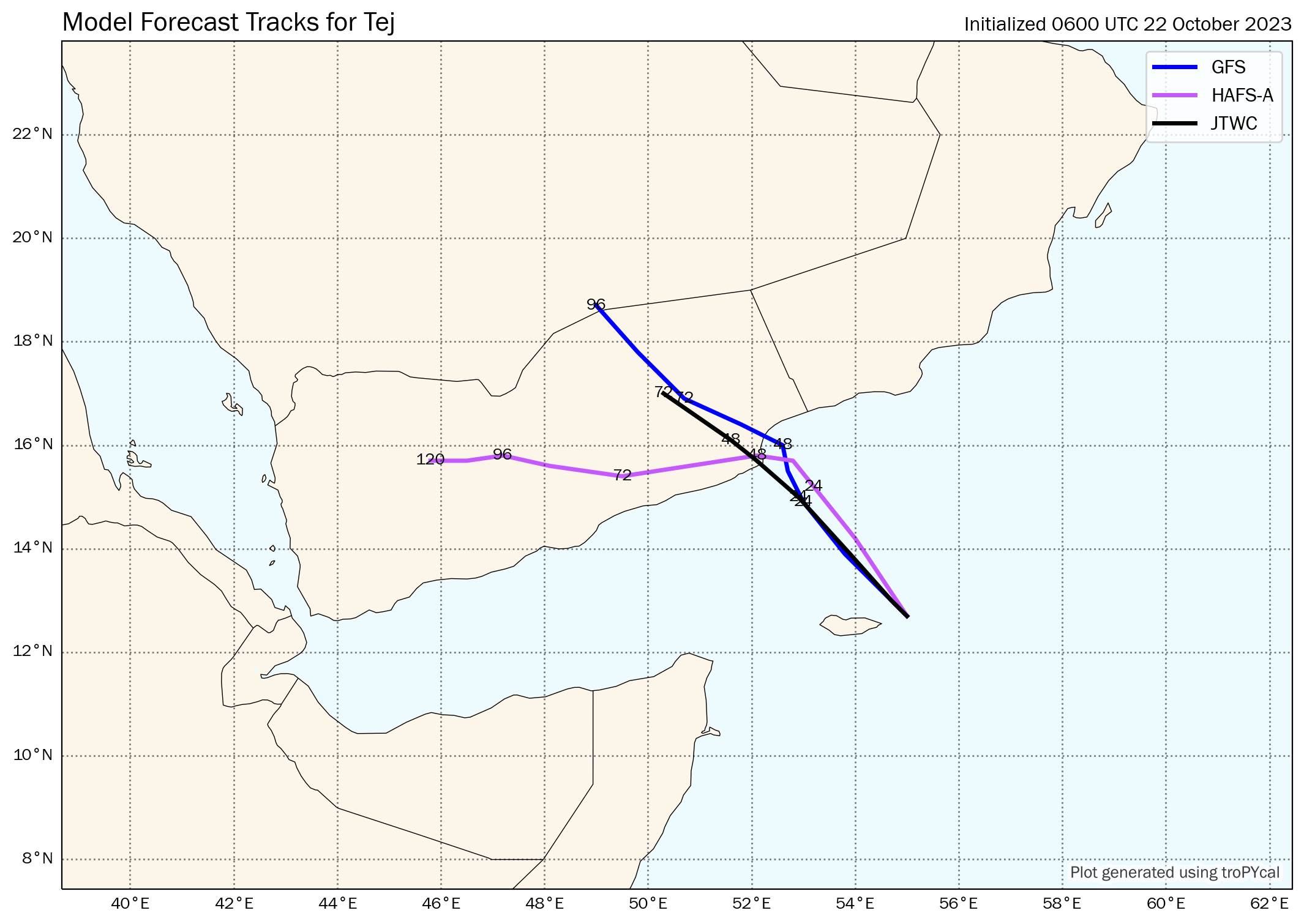
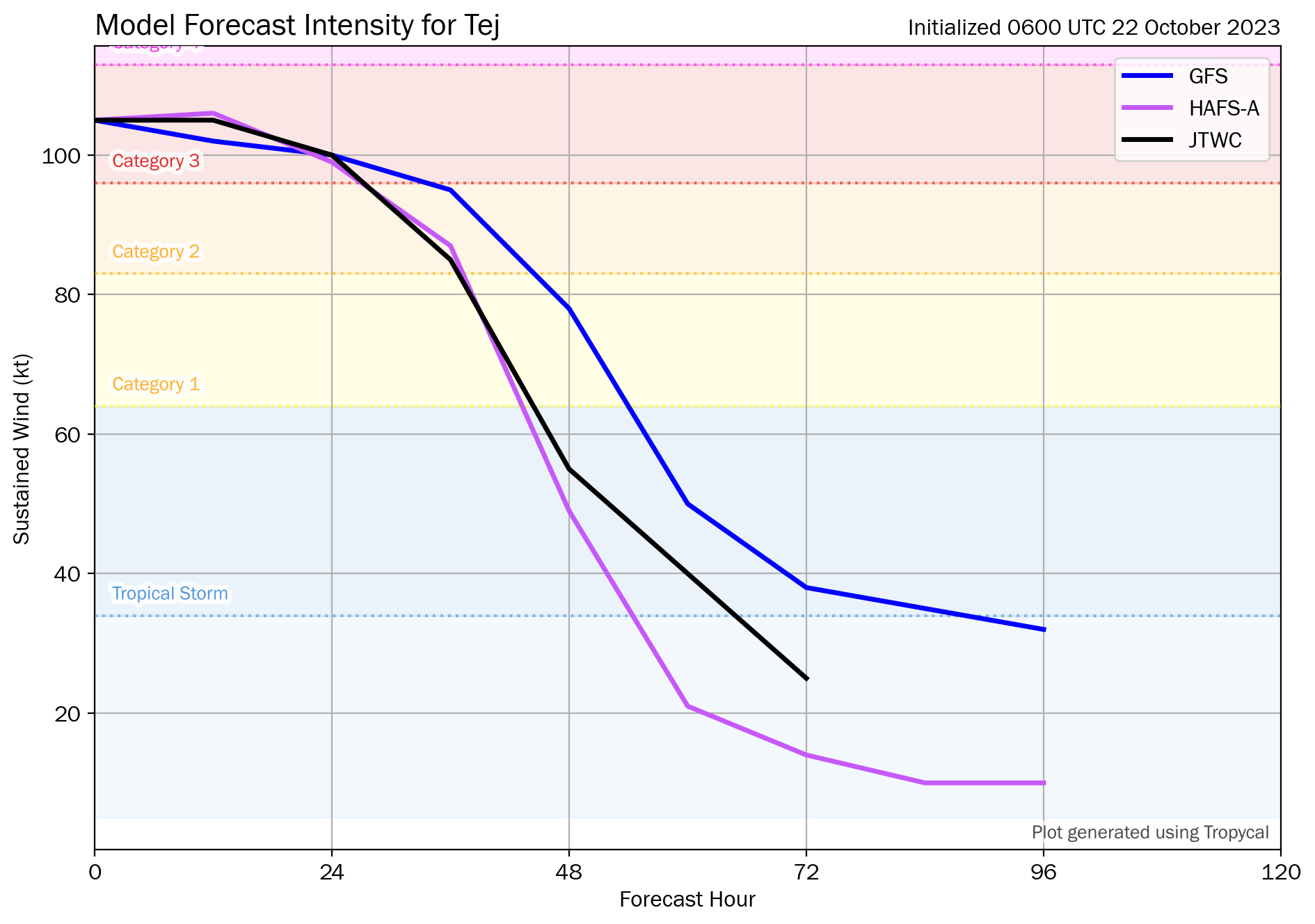
Tej is forecast to decrease in strength as Tej approaches the southern Arabian coast.
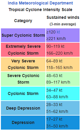
According to the India Meteorological Department, the rough equivalent to a Category 1 hurricane (to a lower-end Category 2 hurricane) is the Very Severe Cyclonic Storm, with a wind speed of 64-89 kt.
Will Tej therefore make landfall as a Very Severe Cyclonic Storm or stronger?
Resolution Criteria
Resolves YES if Tej makes landfall anywhere as a Very Severe Cyclonic Storm or stronger, including Socotra. according to India Meteorological Department (IMD).
Resolves NO if no such information can be found from the IMD before the dissipation, degeneration below cyclonic storm strength, or extratropical transition of Tej.
Will resolve based on IMD data, with supplemented data from JTWC if necessary. I will not bet on this market.
 1,000
1,000🏅 Top traders
| # | Trader | Total profit |
|---|---|---|
| 1 | Ṁ24 | |
| 2 | Ṁ15 |
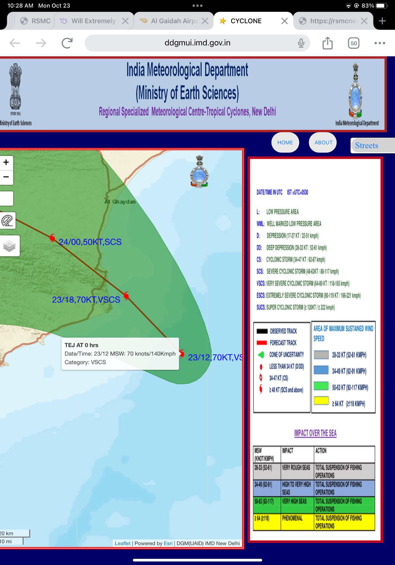
According to an announcement from IMD posted on Twitter/X, Tej has made landfall over the Yemeni coast south of Al Ghaidah around 0230-0330 IST (2130-2230 UTC on the 23rd) as a VSCS. This means the conditions for a resolution of YES has been satisfied. I will leave this market open for another hour for any comments or objections, then I will resolve this market as YES if there isn't any.
@SarkanyVar I got the timing close (21Z) from looking at satellite images, but the AMSU was actually in their window though for landfall at 21:50 UTC.
Still looks strong if anything got stronger according to ADT:
IMD predicts landfall in 2 hours still as Very Severe.:
"THE VERY SEVERE CYCLONIC STORM “TEJ” (PRONOUNCED AS TEJ) OVER WESTCENTRAL ARABIAN SEA MOVED NORTH-NORTHWESTWARDS WITH A SPEED OF 11 KMPH DURING PAST 6 HOURS AND LAY CENTERED AT 1500 UTC OF TODAY, THE 23RD OCTOBER OVER THE SAME REGION, NEAR LATITUDE 15.6°N AND LONGITUDE 52.5°E, ABOUT 230 KM SOUTHWEST OF SALALAH (OMAN, 41316) AND 70 KM SOUTHEAST OF AL GHAIDAH (YEMEN, 413198). LANDFALL PROCESS WILL COMMENCE WITHIN NEXT 2 HOURS. IT IS VERY LIKELY TO MOVE NORTHWESTWARDS AND CROSS YEMEN COAST CLOSE TO AL- GHAIDAH DURING 1800-2100 UTC OF 23RD OCTOBER AS A VERY SEVERE CYCLONIC STORM WITH WIND SPEED OF 125-135 KMPH GUSTING TO 150 KMPH."
Still no landfall, maybe? No official landfall landfall, but in what IMD calls a "landfall process"
"VERY SEVERE CYCLONIC STORM “TEJ” (PRONOUNCED AS TEJ) OVER WESTCENTRAL ARABIAN SEA VERY CLOSE TO YEMEN COAST THE VERY SEVERE CYCLONIC STORM “TEJ” (PRONOUNCED AS TEJ) OVER WESTCENTRAL ARABIAN SEA MOVED NORTH-NORTHWESTWARDS WITH A SPEED OF 9 KMPH DURING PAST 6 HOURS AND LAY CENTERED AT 1800 UTC OF 23RD OCTOBER OVER THE WESTCENTRAL ARABIAN SEA VERY CLOSE TO YEMEN COAST, NEAR LATITUDE 15.8°N AND LONGITUDE 52.3°E, ABOUT 30 KM SOUTH-SOUTHEAST OF AL GHAIDAH (YEMEN, 413198) AND 230 KM WEST-SOUTHWEST OF SALALAH (OMAN, 41316). IT IS VERY LIKELY TO MOVE NORTHWESTWARDS AND CROSS YEMEN COAST CLOSE TO SOUTH OF AL- GHAIDAH WITHIN A FEW HOURS AS A VERY SEVERE CYCLONIC STORM WITH WIND SPEED OF 125-135 KMPH GUSTING TO 150 KMPH (70 KNOTS GUSTING TO 80 KNOTS). LANDFALL PROCESS CONTINUES AND WILL BE COMPLETED WITHIN A FEW HOURS."
Given this satellite image and recent trajectory right before the convection started again, I think the center might be over land already:
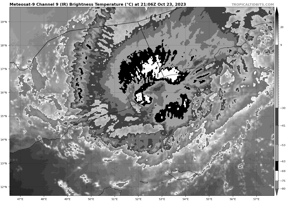
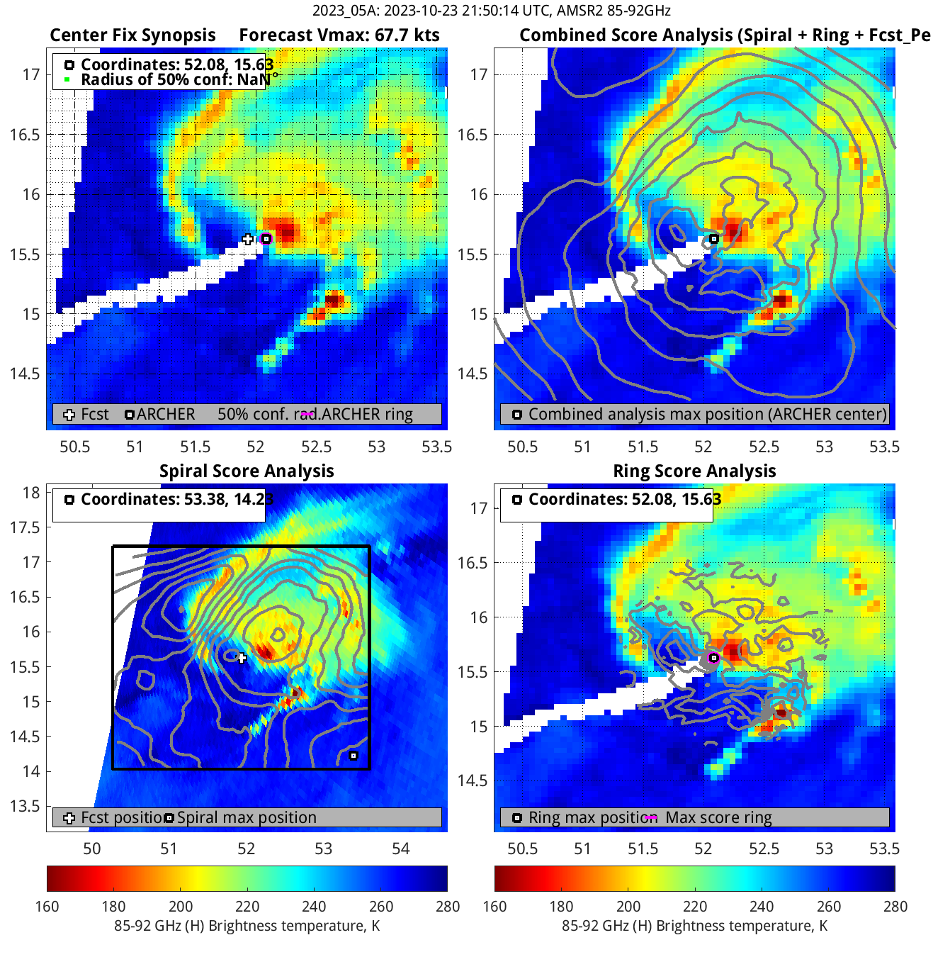
Don't know if the coordinates from these AMSU images from CIMSS are too useful, but from about an hour after that satellite image I posted earlier it has it inland (15.63, 52.08) from Ring Score analysis.
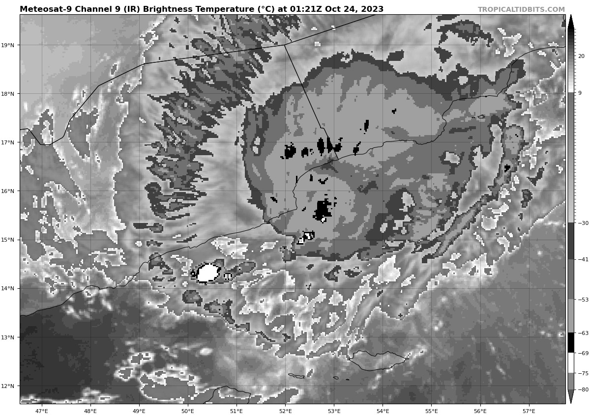
Looks like a lot of convection has also lessened from latest satellite images in last 20 minutes or so:
@parhizj Just found this from IMD's Twitter/X.
https://twitter.com/indiametdept/status/1716628004301070760
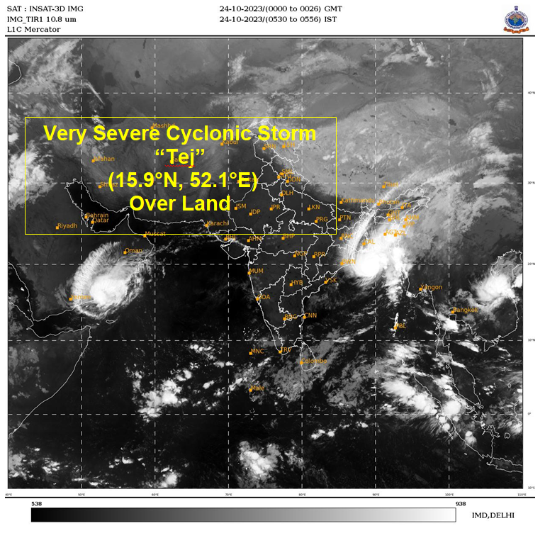
I think it is safe to say IMD deems Tej to have landed and that it's still a VSCS as of 0026 UTC.
@SarkanyVar Yep I found another source saying the same (Edit: SAB (KNES)):
https://www.ssd.noaa.gov/PS/TROP/DATA/2023/bulletins/nind/20231023233005A.html
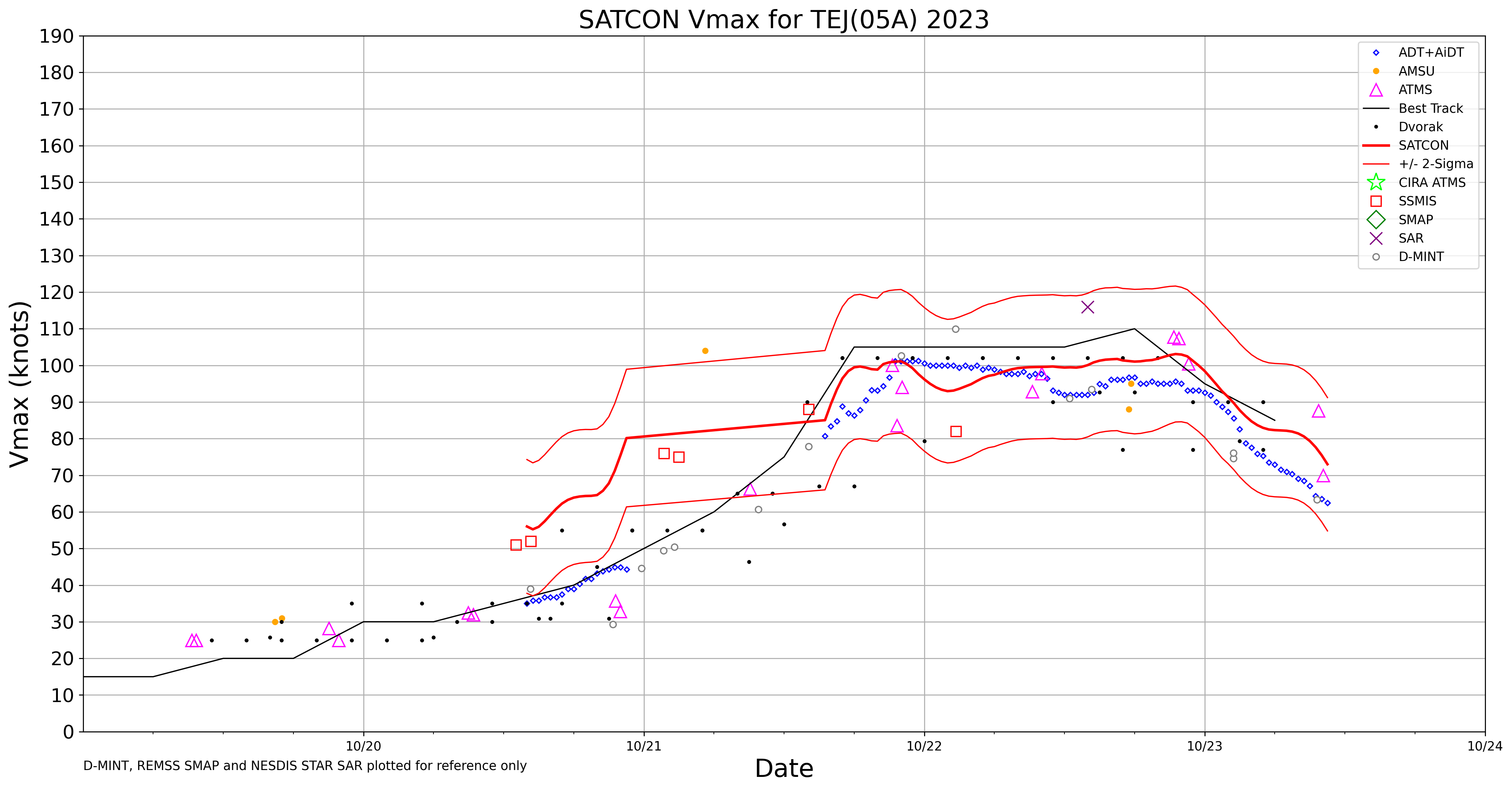
Latest SATCON puts it at 74kt (mainly from objective Dvorak):
Edit: correction the track has been a little to the west of forecast:
And from my perceived motion of the current of the center from satellite imagery it looks like Tej might take it . During the next few hours before landfall it could very well weaken to just a Severe Cyclonic Storm.


I don't know if IMD does landfall updates at landfall time, reporting the storm category at landfall (like the NHC), or if they will announce it as the next advisory (in which case it will be when it might be well inland).
IMD's latest bulletin forecast YES:
"IT IS VERY LIKELY TO CONTINUE TO MOVE NORTHWESTWARDS AND CROSS YEMEN COAST CLOSE TO AL- GHAIDAH DURING 1800 – 2100 UTC OF 23RD OCTOBER AS A VERY SEVERE CYCLONIC STORM WITH WIND SPEED OF 125-135 KMPH GUSTING TO 150 KMPH"
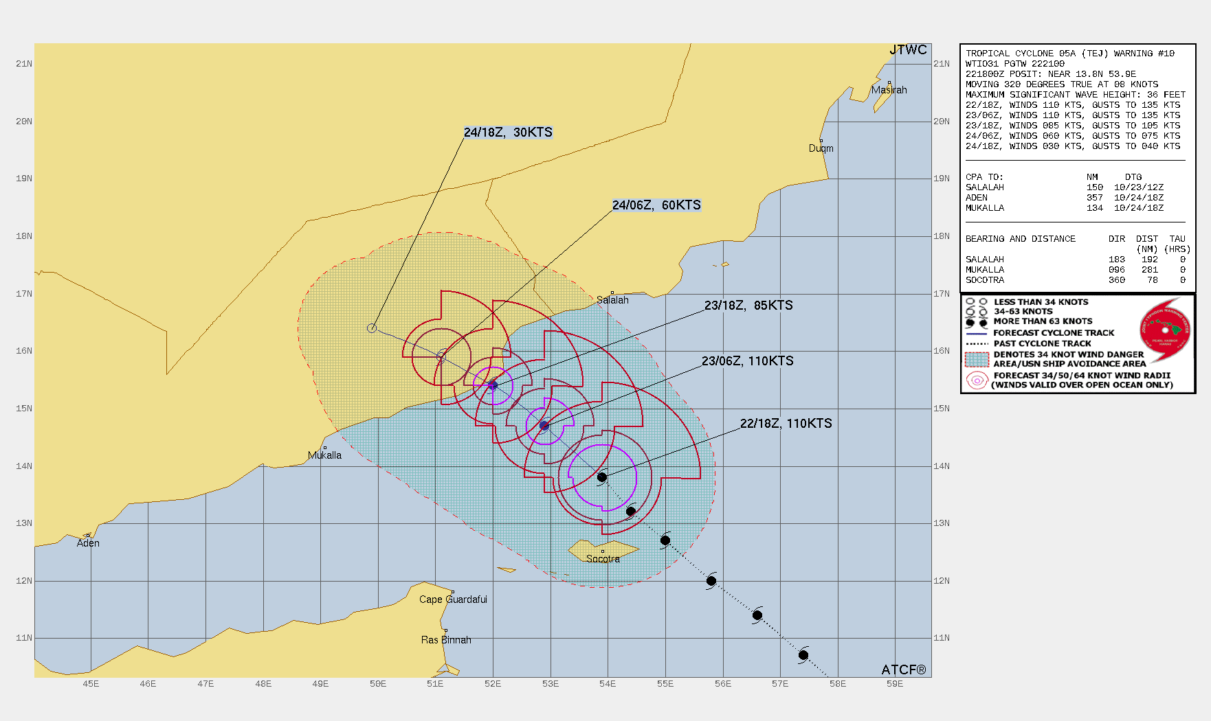
125-135 km/h is on the lower end. JTWC has it at 85 kt right before/near landfall:
@parhizj I will also see if they will do landfall update in this case on their Twitter/X account, such as when they did so for Mocha:
https://twitter.com/Indiametdept/status/1657347723862114305
They made an announcement for anticipated Tej landfall some time ago so I lean towards that they will.
https://twitter.com/Indiametdept/status/1715704538525766000
If they don't, I will attempt to rely on the closest available data points from IMD and JTWC advisories and see if they provide convergent observations. I might also derive a wind speed estimate at landfall with a linear interpolation between two points if the forecasted locations deviate greatly from the coastline.
I looked at one of their past advisories last year and they did provide an estimate of the speed during landfall:
THE CYCLONIC STORM “SITRANG” PRONOUNCED AS “SI-TRANG” OVER NORTH BAY OF BENGAL MOVED RAPIDLY NORTH-NORTHEASTWARDS WITH A SPEED OF 56 KMPH DURING PAST 06 HOURS AND CROSSED BANGLADESH COAST BETWEEN TINKONA AND SANDWIP (41964) CLOSE TO BARISAL (41950) DURING 1600 UTC AND 1800 UTC OF 24TH OCTOBER WITH MAXIMUM SUSTAINED WIND SPEED OF 80-90 KMPH GUSTING TO 100 KMPH. IT LAY CENTERED AT 1800 UTC OF 24TH OCTOBER OVER COASTAL BANGLADESH NEAR LATITUDE 23.70N AND LONGITUDE 90.8 0E, ABOUT 40 KM EAST OF DHAKA (41923), 50 KM WEST-SOUTHWEST OF AGARTALA (42724) AND 120 KM NORTH-NORTHEAST OF BARISAL (41950).