The storm has to have had hurricane strength according to the NHC at the time of landfall. I may wait a couple of days to resolve in case of uncertainty but I will not wait until the next year's NHC report which sometimes includes reassessments.
Landfall: The intersection of the surface center of a tropical cyclone with a coastline. Because the strongest winds in a tropical cyclone are not located precisely at the center, it is possible for a cyclone's strongest winds to be experienced over land even if landfall does not occur. Source: National Hurricane Center
 1,000
1,000🏅 Top traders
| # | Trader | Total profit |
|---|---|---|
| 1 | Ṁ1,118 | |
| 2 | Ṁ697 | |
| 3 | Ṁ239 | |
| 4 | Ṁ216 | |
| 5 | Ṁ137 |
From the latest NHC advisory released minutes ago: "Strengthening is forecast, and Idalia is expected to become a hurricane over the southeastern Gulf of Mexico by early Tuesday. Additional strengthening is likely while Idalia approaches the northeastern Gulf coast."
Forecast to be at least a Cat II storm on landfall:
FORECAST POSITIONS AND MAX WINDS
INIT 27/2100Z 20.1N 85.5W 35 KT 40 MPH
12H 28/0600Z 20.5N 85.3W 45 KT 50 MPH
24H 28/1800Z 21.7N 85.0W 55 KT 65 MPH
36H 29/0600Z 23.4N 84.9W 65 KT 75 MPH
48H 29/1800Z 25.6N 84.5W 75 KT 85 MPH
60H 30/0600Z 28.7N 83.7W 85 KT 100 MPH
72H 30/1800Z 31.3N 81.9W 50 KT 60 MPH...
INLAND 96H 31/1800Z 34.5N 76.0W 50 KT 60 MPH...
OVER WATER 120H 01/1800Z 35.0N 71.0W 55 KT 65 MPH
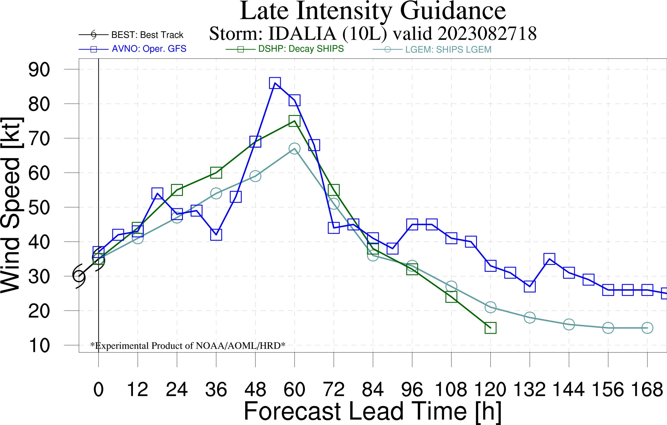
@sarius Late intensity GFS guidance from 18h run (more time data points) shows it weakening slightly before landfall

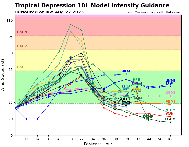
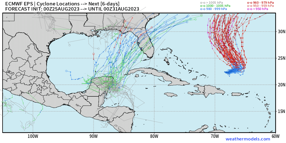
After waking up I have to unfortunately say that TD10 looks more organized yet again, likely to be a tropical storm later today. And all of the major (and ocean integrated!) hurricane models have TD10 making landfall as at least a Cat II. The NHC writes: "There's a notable risk of rapid intensification while the system moves across the record warm eastern and northeastern Gulf of Mexico, which is highlighted by the recent HAFS and HWRF guidance. The new NHC forecast is raised from the previous one, near or above the model consensus, and could be too low."
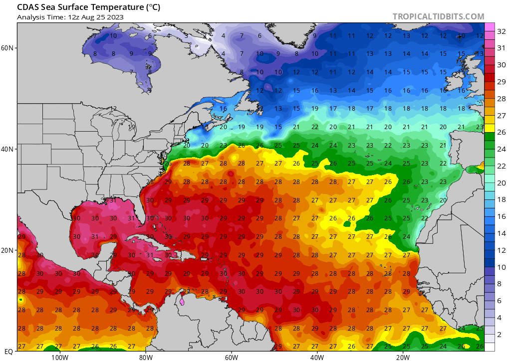
Some of the latest runs from the GFS and the Korean model are now also on board with a major Hurricane. Considering historic intensity accuracy data (favoring the official NHC forecast, HMON, HWRF over the Euro and the GFS) and some hurricane precedent (notably: Michael in 2018 and the 1945 Outer Banks hurricane; maybe also the 1921 Tampa Bay hurricane and events in 1880, 1886) this seems at an above 50% chance of being a Cat I or higher - naive guess 75%. Imo that water is just too damn hot. Though, we won't have a more definitive answer until the 18z runs which are likely going to have integrated the on-site data being collected right now.
FORECAST POSITIONS AND MAX WINDS (from the NHC)
INIT 27/0900Z 20.1N 86.8W 30 KT 35 MPH
12H 27/1800Z 20.1N 86.5W 40 KT 45 MPH
24H 28/0600Z 20.6N 86.3W 45 KT 50 MPH
36H 28/1800Z 21.7N 86.3W 50 KT 60 MPH
48H 29/0600Z 23.3N 86.2W 60 KT 70 MPH
60H 29/1800Z 25.7N 85.7W 75 KT 85 MPH
72H 30/0600Z 28.5N 84.7W 80 KT 90 MPH
96H 31/0600Z 33.0N 81.2W 45 KT 50 MPH...INLAND
120H 01/0600Z 35.0N 75.5W 35 KT 40 MPH...OVER WATER
@sarius My local meteorologist explicitly said this morning 'I think it's likely it will be a landfalling hurricane' 😭 I am going to be patient and wait for the ECMWF updates this afternoon before updating. NOAA Hurricane hunter aircraft are also going over the area ~now too.
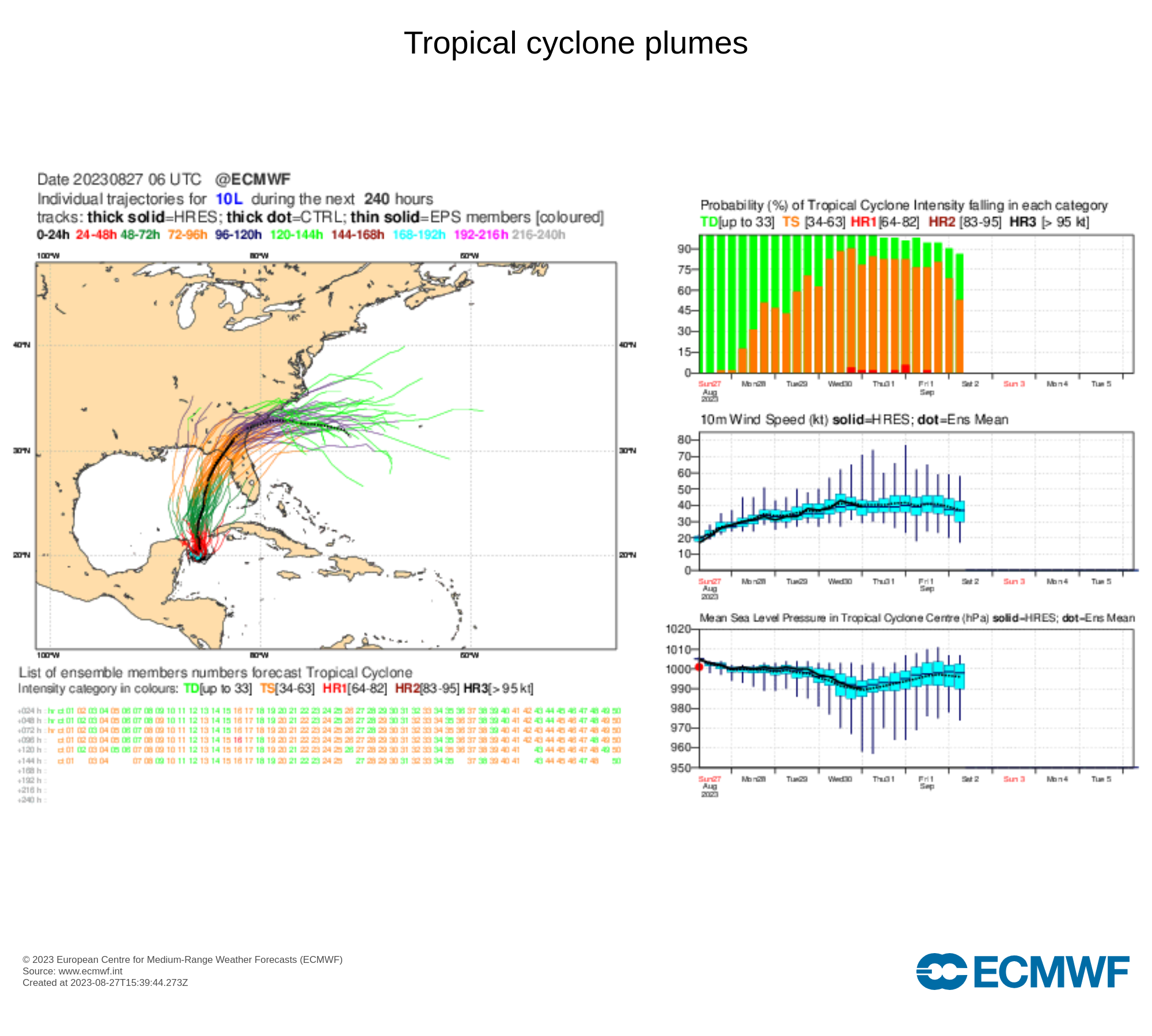
From AOML's model viewer:
(This is early guidance so the late models may bring the speeds down.)
The official NHC forecast from the latest advisory has it at 80kt before landfall, still on the 30th:
Using the NHC forecast, I assign a (naive) probability of 63% (72h out).
For the ECMWF (00z run) they still show only a couple members of the ensemble with it as a hurricane, putting the probability at ~4%. As far as I can tell the ECMWF ensemble members showing a much higher intensity storm push the landfall later where as the early guidance from NHC still show it arriving on the morning of Aug 30.
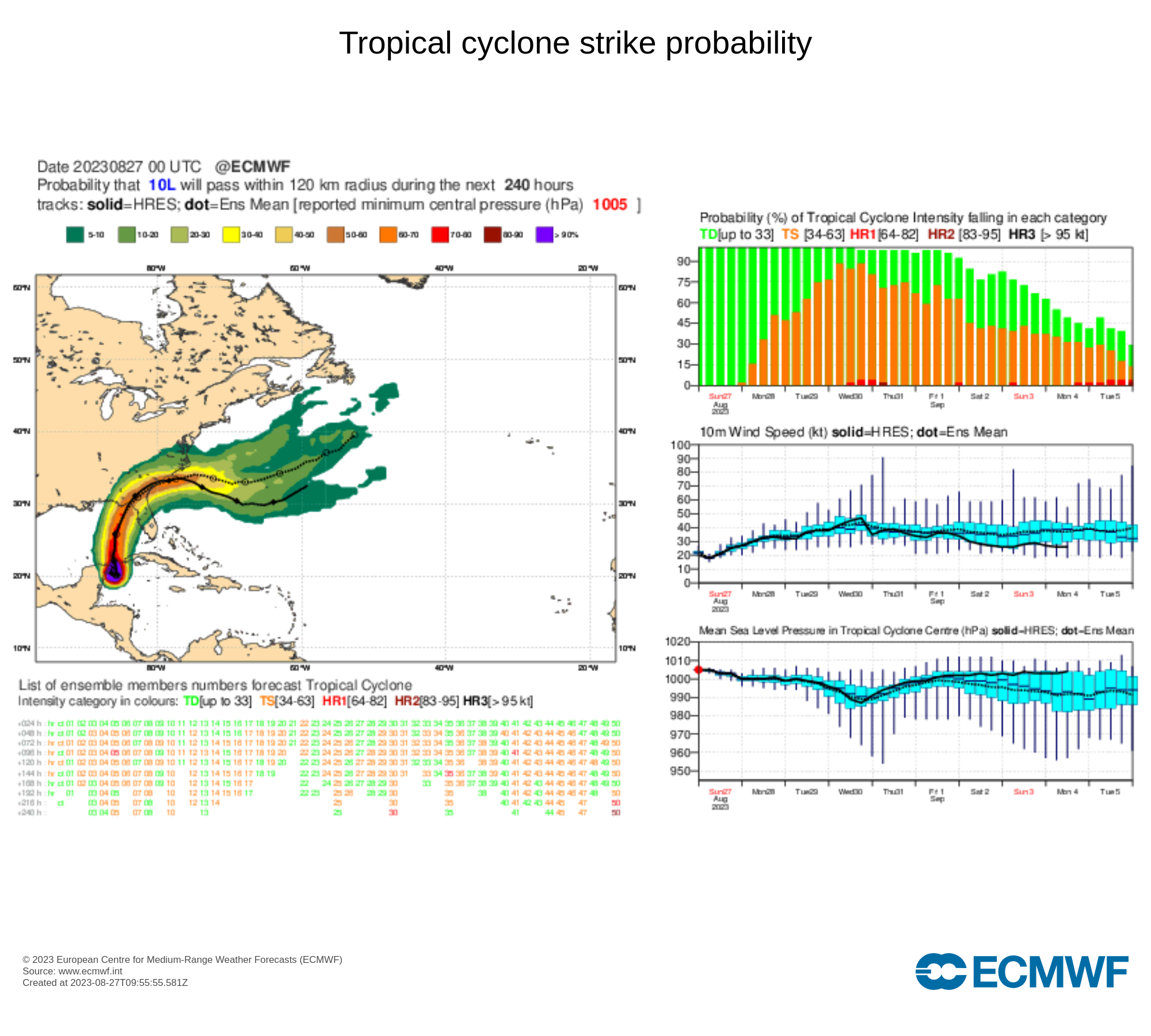
The ECMWF genesis page however does show the probability a bit higher at between 5-10%:
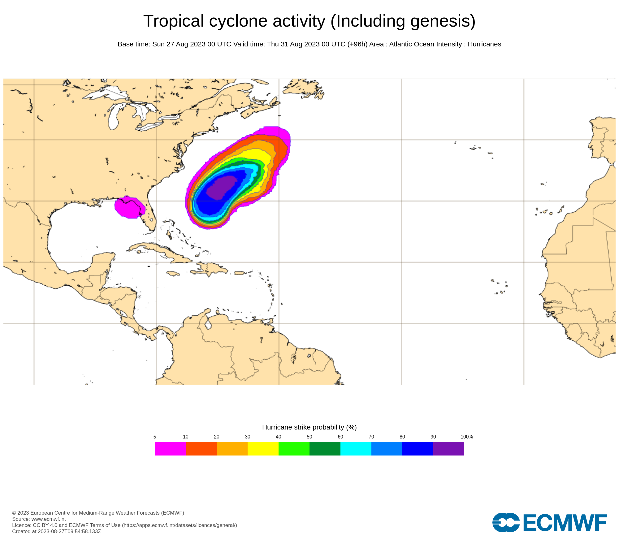
I'll take the middle of these two at 7% for the ECMWF probability of a hurricane.
Taking the middle of the NHC and ECMWF (7% and 63%) I get a middle probability of ~35% right now.
ECMWF 06 update still shows low probabilities: histogram probability (no HRES) shows about the same % (maybe 1 less member so maybe a bit lower):
NHC advisory update shows the same official 80kt prediction. In the early guidance from 12h the observed speeds have been a bit lower and some of the models have moved down the intensities (nothing over 90kt any more)
From AOML's viewer:
Late Guidance from 06h (Euro IFS shows it doesn't predict a hurricane is likely):
Early Guidance from 12h (most of the models are below official forecast but some still showing it will be a hurricane):
Some of the models show a slightly lower track now for the early guidance:
@NicoDelon I think it’s worth clarifying what exactly you’ll use to judge the strength of the storm at landfall if the NHC doesn’t mention in their advisories explicitly “made landfall as a Hurricane/tropical storm”? In other words, if the explicit wording is not in the NHC advisory/discussions, will you use the advisory reported strength when it is already inland or the closest advisory before the inland report.
@parhizj Does it often happen for them to not mention it in their advisories or in their other releases? If they don’t mention the strength at the time of landfall anywhere I’ll use Tropical Tidbits, assuming he releases an assessment. If he doesn’t then I’ll use the closest advisory before the inland report.
@NicoDelon IOW I’ll do my best to get info about wind speeds at landfall from trustworthy sources if the NHC doesn’t deliver.
@NicoDelon The title of the advisories (and intermediate) will always have the current strength of the storm at the advisory time (which are usually 3 hours apart including intermediate advisories), but the discussion page (which is updated every 6 hours) is what may say explicitly whether it is estimated to be made landfall as a hurricane or tropical storm (for example: https://www.nhc.noaa.gov/archive/2023/ep09/ep092023.discus.018.shtml?). I don't actually know whether they always explicitly mention the estimated strength of the storm at landfall.
@parhizj Okay, if there’s a doubt I’ll extrapolate from NHC, Tropical Tidbits, and reliable news reports I can find. I’ll use my best judgment.
It is a TD now (TD 10).
https://www.nhc.noaa.gov/refresh/graphics_at5+shtml/205449.shtml?cone#contents
https://www.nhc.noaa.gov/text/refresh/MIATCDAT5+shtml/262053.shtml? NHC Forecast from link to the left:
FORECAST POSITIONS AND MAX WINDS

INIT  26/2100Z 21.1N  86.1W   25 KT  30 MPH
 12H  27/0600Z 21.0N  86.3W   30 KT  35 MPH
 24H  27/1800Z 20.9N  86.2W   35 KT  40 MPH
 36H  28/0600Z 20.8N  86.1W   40 KT  45 MPH
 48H  28/1800Z 22.0N  85.7W   45 KT  50 MPH
 60H  29/0600Z 24.0N  85.6W   50 KT  60 MPH
 72H  29/1800Z 26.3N  85.3W   65 KT  75 MPH
 96H  30/1800Z 31.5N  83.0W   45 KT  50 MPH...INLAND
120H  31/1800Z 35.0N  79.0W   30 KT  35 MPH...INLAND
This puts it as a Category 1 before it makes landfall ~ the morning of August 30. Using the data above (with the forecast intensity error from 2022) I come up with a (naive) probability of 38% of it being a hurricane (72h out) using the NHC forecast data alone.
The ECMWF genesis (hurricane) % still (update from ~3 hours ago) shows it < 5% of becoming a hurricane. The middle of these two probabilities would be ~ 21% then ((4+38) / 2). Hopefully the ECMWF 18h forecast will include TD 10 strike probabilities so I can update again before I go to sleep.
I forgot they also have surface wind speed calculation as a probability but this might be deceptive as it won’t necessarily match the advisories description:
https://www.nhc.noaa.gov/refresh/graphics_at5+shtml/234234.shtml?hwindloop?#wcontents
They also have it less than 5% according to the above graphic but also forecast it becoming a hurricane… this is a bit confusing
threading the needle?! Recon is picking up too and Florida counties from Panama City to Ft. Myers are under a state of emergency. I do not like this trend. The Gulf in August is scary and if this stays further to the east and over water as it comes into the Gulf, things might get really scary. HWRF (though, know to be a little overexcited) does in fact turn this into a Cat III - Cat IV....
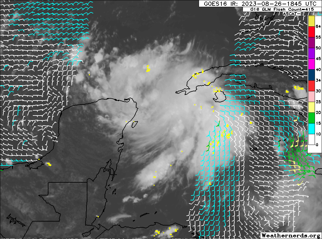

@LBeesley SHIPS has it at Cat I! A lot still depends on where exactly the depression forms and how long it takes for it to overcome the (slight) wind shear associated with the upper level trough dipping down from the continental U.S.. However, sea surface temperatures in the eastern Gulf are just insane. I'm pretty sure this market will go up as we get more development. And the system is currently organizing quite a bit faster than I expected.