Resolves based on operational intensity, not post-season adjustments
Created a pair of follow-up markets, one for the current Atlantic tropical depression (likely to be named Gordon) and another for the Eastern Pacific system with an 80% chance of formation (likely to be named Ileana):
https://manifold.markets/SaviorofPlant/what-will-be-the-maximum-intensity-uc6tivnaaz
https://manifold.markets/SaviorofPlant/what-will-be-the-maximum-intensity-h7jxd27n5f
https://www.nhc.noaa.gov/text/refresh/MIATCUAT1+shtml/112157.shtml
@SaviorofPlant Landfalling Cat. 2
...FRANCINE MAKES LANDFALL IN SOUTHERN LOUISIANA...
...500 PM CDT POSITION UPDATE...

Francine has made landfall in southern Louisiana in the Parish of
Terrebonne, about 30 miles south-southwest of Morgan City, as a
Category 2 hurricane.  Maximum sustained winds are estimated to be
near 100 mph (155 km/h).@parhizj Will just resolve now, if it somehow strengthens over land or reforms I can ask for unresolve
Congrats to people who bet against the NHC ... Not sure if intensification right before landfall was in all your scenarios or not though... it sure wasn't for me!
@parhizj Hurricane models were showing intensification right until landfall despite high shear. I think there was a HAFS run a couple days ago which showed exactly 971 mb a few hours before landfall. Regardless, the storm almost achieved that pressure while keeping Cat 1 winds, so I was probably a bit overconfident, even though it paid off this time
@parhizj Also, I would put the odds of the "market reopens" scenario <1%, but never say impossible. HWRF shows Francine degenerating but what's left of it re-emerges over the Gulf in about a week. Even if something forms from that, it's dubious whether it would keep the name Francine (and profoundly unlikely that it gets strong enough to change the resolution of this market), but these reformation scenarios have happened a couple times, most recently with Paulette 2020.
BULLETIN
Hurricane Francine Advisory Number  13
NWS National Hurricane Center Miami FL       AL062024
400 PM CDT Wed Sep 11 2024

...FRANCINE BECOMES A CATEGORY 2 HURRICANE AS THE EYE APPROACHES
THE LOUISIANA COAST...
...LIFE-THREATENING STORM SURGE AND HURRICANE CONDITIONS SPREADING
ONTO THE LOUISIANA COAST...Live updates: Hurricane Francine approaches Louisiana landfall | CNN
"The hurricane is contending with storm-disrupting wind shear this morning, which has helped limit its overall strength. Francine is now expected to remain a strong Category 1 hurricane at landfall instead of a Category 2, according to the NHC"
Hmm oops I forgot to update before it closed, anyway, I'll post this as a note:
https://www.nhc.noaa.gov/text/refresh/MIATCUAT1+shtml/110321.shtml
20 minutes after their 11pm advisory they increased the wind speeds by 10kt... (from 65 to ~75kt)
https://www.nhc.noaa.gov/archive/2024/al06/al062024.fstadv.010.shtml?
@ChristopherRandles I'm inclined to trust the hurricane models here, which unanimously show the hurricane reaching a pressure around 970 mb. It's already a Cat 1; doesn't need that much additional strengthening to reach Cat 2
@SaviorofPlant I spent too much time on Gordon today... not enough on this market...
Edit:
Last recon has pressures of 975-977 at the moment..
https://cyclonicwx.com/recon/mission/FRANCINE_AF301_1106A/
Based on my notebook this already has a 25-40% of being classified a Cat 2 on current pressure alone,and its just getting started...
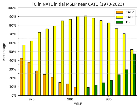
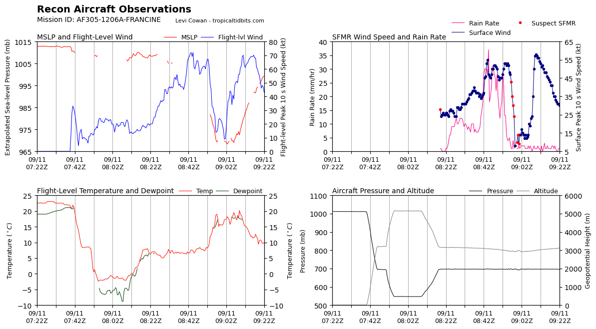
Latest recon shows very low pressure (around the 970 mb predicted by the hurricane models) but winds significantly less than what we'd expect from a storm of that intensity. There's still some time for them to catch up, but I may have placed too much emphasis on the predicted pressure.
I've bet up Cat. 1 based on my advisory error notebook and the 5pm NHC discussion (predicting a peak cat. 1):
Francine has about 24 h to strengthen over warm water before it
encounters strong shear near the Louisiana coast.  While there
remains a possibility that dry air entrainment could continue to
reduce the intensification rate, the intensity forecast continues
to call for steady to rapid strengthening during this time based on
the otherwise favorable conditions, and the forecast peak intensity
of 80 kt is at the high end of the intensity guidance.
Intensification is expected to stop near or just before landfall,
and rapid weakening is expected after landfall.  The global models
continue to show the remnants of Francine dissipating after 96 h,
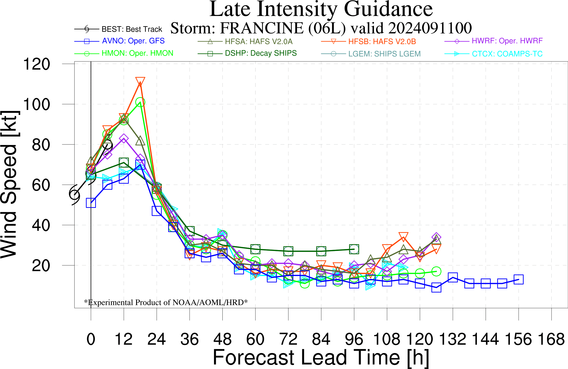
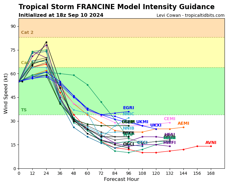
and the intensity forecast again follows that scenario. The hurricane models are more aggressive than the official NHC forecast right now - HWRF shows the system reaching 977 mb pressure (although the current run is 5 mb deeper at 30 hours), while the HAFS-A and HAFS-B show 969 and 962 mb respectively. The HMON also shows 962 mb. Hurricane Zeta was a low-end Cat 3 storm at 970 mb, which seems like the ceiling for this storm.
